The post Rick Rojatt—The Stuntman Who Became Famous as the Human Fly appeared first on .
]]> While many people crave for fame and fortune, there are some who, having tasted each, prefer to revert to anonymity. Rick Rojatt, The Human Fly, is someone in this category. He appeared seemingly out of nowhere to astound the world with his extraordinary, death-defying stunts and disappeared almost as suddenly and offering no explanation. Throughout his career, he had kept his identity a closely guarded secret, and it has remained so ever since.
Rick Rojatt
In 1976, Joe and Dominique Ramacieri, who were Montreal-based sausage-makers and ran a family business called Roma Foods, decided to expand into show business. They formed the Human Fly Spectaculars, Ltd., and hired a stuntman named Rick Rojatt to perform attention-grabbing stunts. Rick Rojatt always appeared in public in a red felt full-body costume that masked his identity. The suit had white stripes and sequins, and he often wore it with a cape and a helmet. He also carried a sceptre sometimes.
As Rick Rojatt’s popularity grew, the public became interested in his personal life, and he had quite a backstory to impart.
According to what Rick Rojatt told the media, he was a Canadian stuntman from Montreal, Quebec, who went by the professional name ‘The Human Fly’. He claimed to have been active as a stuntman in Hollywood in the 1970s, although the California Union has no record of him in their roster of stunt performers. And, as he always wore a red and white mask to cover his face, nobody ever knew what he looked like.
He did, however, reveal some parts of his personal life in an interview with People magazine. According to him, five years before he emerged into the limelight, he had lost his wife and four-year-old daughter in a horrific car accident in North Carolina, and he had barely survived it himself. It took him four years and 38 operations that involved augmenting his skeleton with 60 percent steel to get back on his feet again.
He had since rebuilt his health by following a strict regimen of rising at 3 a.m. every day and going for a six-mile run. After that, he bathed in an ice cube-filled bath.
His steel-enhanced skeleton, or so he claimed, made him almost indestructible, and that was why he dared to perform his incredible stunts.
In another version of the tale, he claimed he was injured after an angry female gorilla flung him across the enclosure while he was working in the Montreal Zoo.
Rick Rojatt’s Aeroplane Wing Walk
In 1976, when he was 29 years old, Rick Rojatt performed the famous stunt that made him a household name across USA and Canada. He walked over the wings of a Douglas DC-8 airplane that was in mid-flight. His company, the Human Fly Spectaculars, Ltd., made a promotional film of the event called “The Human Fly Challenges the Mojave Skies.”
Wearing a red and white mask, a white cape, and a steel-reinforced jumpsuit, with the UCLA marching band playing in the background, the Human Fly made his appearance at the Mojave, California, airport. He informed the gathered media people that he had prepared for the stunt by practising in a wind tunnel. A crane lifted him on the waiting airplane, and his three assistants strapped his chest and legs onto a steel brace device they had fixed with cables to the plane. To help him breathe while in flight, his nose and mouth had oxygen tubes in them.
Once he was in position, he gave a thumbs-up, and the pilot Clay Lacy took off and flew the four-engine jet plane up to 500 feet at a speed of 280 mph over the Mojave desert. They were in the air for about 20 minutes. As Rick Rojatt walked across the plane’s wing, they got caught in a rainstorm, and, at that speed, the water drops hit him so hard that Rick passed out from the excruciating pain. He had to be hospitalized for two weeks to recover.
He repeated the stunt, however, the following year. The only issue in that instance was that his helmet visor came off during the flight, and he had to squint in the high winds.
Revelling in the publicity from these stunts, Rick Rojatt informed People magazine that he had had no reason to be afraid. He also told them that he was planning on performing more death-defying stunts in the near future. These included sky-diving over the English Channel, jumping into a water tank from the CN Tower in Toronto, and sky-diving over Mount Everest.
The purpose behind these stunts was simple, as his manager explained to the media people. It was to make money.
Rick Rojatt’s Motorbike Jump
One of Rick Rojatt’s to-do items was to beat Evel Knievel’s world record of jumping a motorbike over 13 school buses. In 1977, he announced that he would out-do that feat by driving over 27 vehicles. He intended to jump over 36 of them but was dissuaded from the idea by Ky Michaelson, who fitted out his motorbike for the jump.
The motorbike was a 1977 Harley Davidson XL-1000 Sportster, and Ky Michaelson fitted two hydrogen peroxide rockets, each with a 1500 pound thrust, on top of each other under the fuel tank. With these rocket engines, the motorbike could go over 300 mph.
The stunt took place as a half-time show during a disco concert in Montreal’s Olympic Stadium, featuring Gloria Gaynor and various other performers.
Right before the stunt was to happen, Ky Michaelson took a look at the jumping and landing ramps and noticed that the workmen hadn’t built them to the required specifications. He immediately pointed that out to Rick Rojatt and his team and asked them to call off the jump that night. He also reminded them that Rick Rojatt hadn’t even test-driven the motorbike, and to attempt the stunt in these conditions would be disastrous. They refused to listen, however.
According to Ky Michaelson, Rick Rojatt looked completely drunk or drugged. He asked him how to operate the motorbike and then got on it and took off, with white smoke emitting from the exhaust and the music blaring in the background. As the crowd watched, he soared off the launch point and flew over the buses. He managed to reach the 19th bus, and then the motorbike flipped over and crashed on top of him. After the crash, he and the bike went sliding at high speed over the roofs of the remaining buses and then hurtled down the landing ramp.
A silence enveloped the crowd. Everyone thought Rick Rojatt was dead. Nobody could come out of such a crash unscathed. As it turned out, though, if anyone could survive it, it was Rick Rojatt. He had not only broken Evel Knievel’s world record by jumping over 19 buses, but he had also managed to stay alive too. The stunt cost him a broken ankle and various other injuries, but he was otherwise alright. He even waved to the public as the medics carried him off on a stretcher to the ambulance, his mask still in place to safeguard his anonymity.
However, that was the last time anyone saw him in public as The Human Fly.
Thereafter, Rick Rojatt simply disappeared from the public eye, and no one ever heard from him again.
Rick Rojatt: The Inspiration Behind Marvel Comics’ The Human Fly
After Rick Rojatt became a public celebrity with his airplane walk, Marvel Comics was inspired to base a new character, The Human Fly, on him. They gave him the slogan ‘The wildest superhero ever because he’s real!’ The character had the same fantastic back history as the real Rick Rojatt, performed stunts to give money to children’s charities, fought off villains, and saved children in danger.
Written by Bill Mantlo, with inputs from Marvel’s other writers and editors, the first issue of the comic book came out in 1977. It was a short-lived series, lasting from September 1977 to March 1979, with only 19 issues. However, it was quite popular for a while, and the character received a lot of fan mail. Marvel included it in each comic book under the section titled ‘The Fly Papers’.
The real Rick Rojatt—in costume—helped with the publicity blitz by visiting sick children in hospitals and by being a featured guest at children’s charity events. Along with posing for photographs with his fans and signing autographs at each event, he fought off and defeated villains before they could steal the money, to the cheers of everyone present.
What happened to Rick Rojatt?
After Rick Rojatt’s disappearance, his fans made many attempts to track him down and discover what had happened to him. The Ramacieri brothers were not much help, beyond informing the public that they had hired several stuntmen to perform in costume. They hinted that perhaps Rick Rojatt had switched careers to become a musician. Beyond that, everyone came up against a blank wall. There was no mention of the stuntman in any newspapers, not even in the obituary sections. Rick Rojatt’s exact whereabouts remained unknown.
For more unusual stories & intriguing news follow STSTW Media on Instagram and Facebook. Also, join our live chat discussion on Twitter.
Do you have a story/photo for us?
We welcome your contribution at [email protected]. Please include your name, city, state, and country.
Fact Analysis:
STSTW Media strives to deliver accurate information through careful research. However, things can go wrong. If you find the above article inaccurate or biased, please let us know at [email protected].
RELATED
 October 5, 2019 Jim Corbett: A White Hunter Who Became Saviour of Tigers
 April 8, 2020 Mary Ann Bevan- Story of the World’s “Ugliest Woman” and Her Life with Acromegaly
 March 30, 2020 Dr. William Chester Minor: A Learned Lexicographer or a Meritorious Madman?
 November 8, 2019 Tim Berners-Lee, the Inventor of World Wide Web: A Leader in the Face of a Revolution
The post Rick Rojatt—The Stuntman Who Became Famous as the Human Fly appeared first on .
]]>The post Green Flash: An Incredible Meteorological Phenomenon That Occurs at Sunset and Sunrise appeared first on .
]]>
The stages of green flash. (Brocken Inaglory/Wikimedia Commons)
“It’s said that once you’ve seen a green flash, you’ll never go wrong in matters of the heart.”
Ever since Jules Verne included the green flash phenomenon in his popular science-fiction novels, myths about it have taken off into the wind. Although, it’s a rarity to witness this phenomenon. If you are lucky or quick, you may be able to see a green flash when the sun is setting. Sometimes, it also occurs when the sun is rising or under specific atmospheric conditions when the sun is high in the sky.
The green flash phenomenon
Pilots, when flying westward, have reported seeing the green flash phenomenon at the time of sunset. This phenomenon usually lasts for one to two seconds, however, Polar explorer Adm. Richard Byrd and his crew while on an expedition to Antarctica in 1929 claimed to have seen it for 35 minutes. These sights are easy to see from a mountaintop and when along the seaside due to an unobstructed vision of the horizon.

The sequence of M-Mir green flash phenomenon. (Ityllux/Wikimedia Commons)
Types of green flashes
According to the American Association for the Advancement of Science, green flashes fall in four categories:
Inferior mirage or I-Mir: It occurs when the water surface is warmer than the air right above it. The inferior mirage flash that you see then is oval and flat and lasts around one to two seconds.
Mock mirage or M-Mir: Mock mirage flashes appear higher up in the sky and when the water or earth surface is colder than the air above it. One will see these green flashes as thin strips coming off the sun. They, like Inferior Images, only last for about one to two seconds.
Subduct flash: Subduct flashes are quite rare and occur due to the atmospheric inversion phenomenon during which the sun appears to take on an hourglass shape. It happens when cold air and moisture get trapped near the ground level by a warm air layer. The green subduct flash then appears at the sun’s top region. It lasts for about 15 seconds.
Green ray: A green ray is a comparatively rarer phenomenon. It usually occurs for a second, right after the sun has set, with a green ray emanating up a few degrees from the green flash up. It only occurs if the inferior mirage, mock mirage, and subduct flash are brighter than normal, and the atmospheric conditions are hazy.
Why the green flash phenomenon occurs?
When the light from the sun reaches the earth, its atmosphere acts as a prism and separates the light into different component colours. The colours with shorter wavelengths, such as blue, green, and violet, have stronger refraction than those with longer wavelengths like orange, red, and yellow.

Green flash above the solar disc. (ESO/G. Lombardi)
As the sun dips below the horizon, the atmosphere absorbs the orange, red, and yellow colours and scatters the blue and violet light colours. That leaves the green light colour, and that is why it is visible when the sun is setting or rising. And due to the layering of the atmosphere caused by temperature differences, the green flashes appear as ripples from high elevation points like mountaintops.
Photographs of the green flash phenomenon
The first colour photograph of the green flash phenomenon is from 1960, and a photographer named D.K.J. O’ Connell took it. At the time, he was at the Vatican Observatory to observe the sunset. Since then, various people have managed to photograph or video this phenomenon.
Green & red rims of the sun
Green rims about the sun are more common than green flashes. They are prominent at the time of sunset and sometimes transform into a green flash and back, but are difficult to see with the naked eye. Using a binocular or telescope for viewing is not advisable as they are harmful to eyes. One may see it safely, though, if projected as a magnified image on paper. The green rim grows fainter and is overpowered by the red rim as the sun touches the horizon.

Green & red rim of the setting sun. (Brocken Inaglory/Wikimedia Commons)
The green flash phenomenon in popular culture
As you might expect with one of the many amazing natural occurrences that have intrigued people over the centuries, the green flash phenomenon has figured prominently in popular culture. The famous science-fiction writer, Jules Verne, mentioned the phenomenon in his 1882 novel, The Green Ray, as well as in his 1905 book, The Lighthouse at the End of the World. Other novels that mention it include Victoria Holt’s Pride of the Peacock from 1976, William S. Burroughs’ Cities of the Red Night from 1981, Carl Hiaasen’s Flush from 2005, and Elizabeth Wein’s Code Name Verity from 2012.
Many musicians have also found the green flash to be inspirational. In 1916, Mario Castelnuovo-Tedesco composed II Raggio Verde, op. 9, a piano solo that expounded upon the emotions arising from seeing the phenomenon. Much later, in 1991, Gavin Bryars debuted his orchestral composition, The Green Ray.
The films that feature the green flash phenomenon or use it as a plot device include Pirates of the Caribbean: At World’s End from 2007 and Blue Lagoon: The Awakening from 2012. It also appears in episode 982 of the Pokémon Sun & Moon anime.
So, if you plan on seeing the green flash. Wait for a clear, cloudless, and haze-free day, and keep your eye on the distant horizon. Even if it doesn’t make you an expert in sentimental matters, you will be in the lead when it comes to the meteorological ones.
Caution: Since looking at it with the naked eye is likely to harm the eyesight, one should be precautious and see it through a regular camera or a video camera lens.
For more unusual stories & intriguing news follow STSTW Media on Instagram and Facebook. Also, join our live chat discussion on Twitter.
Do you have a story/photo for us?
We welcome your contribution at [email protected]. Please include your name, city, state, and country.
Fact Analysis:
STSTW Media strives to deliver accurate information through careful research. However, things can go wrong. If you find the above article inaccurate or biased, please let us know at [email protected].
RELATED
 November 13, 2018 Luigi Galvani: The Man Who Fuelled the Idea of Re-Animating Human Corpses
 September 18, 2019 Understanding Day Length Fluctuations – What They Are and What Causes Them
 August 10, 2019 Eigengrau is the Dark Gray Colour That Most People See in the Absence of Light
 April 15, 2019 Vantablack: A Manmade Substance that is Blacker than the Blackest of Black
The post Green Flash: An Incredible Meteorological Phenomenon That Occurs at Sunset and Sunrise appeared first on .
]]>The post Why the Apollo 11 Astronauts Went through Customs & Immigration after Entering Earth? appeared first on .
]]>The return of the Apollo 11 astronauts
On 24 July 1969, Neil Armstrong and his fellow astronauts, Buzz Aldrin and Michael Collins, returned to Earth after completing the Apollo 11 mission. The crew brought their space shuttle down in the Pacific Ocean, 1480 km to the south-west of Hawaii, where the U.S. Navy ship, the USS Hornet, picked them up. It took two days—during which the astronauts remained quarantined in a NASA trailer to prevent the spread of any moon germs and diseases they might have inadvertently brought back. The astronauts emerged from the trailer in biological containment suits and disembarked from the ship and travelled to Houston for a further three weeks’ quarantine.
Going through Customs
According to popular lore, when they got back to the USA, the three astronauts had to go through immigration and fill out customs forms. Not only that, but they had to declare their cargo too. As it turns out, no, this did not happen. The astronauts were not bogged down by any customs paperwork on their return.
Read more: Did Man Really Land on Moon? The Dilemma of Apollo 11’s Missing Tapes
The customs form on the U.S. Customs and Border Protection Service website is authentic, of course, but it was more of a practical joke than a requirement. The Customs Service’s District Director for Hawaii created it, and, although the form gives its filing location as Honolulu Airport, the astronauts signed it with an auto-pen at the NASA headquarters later that year. On the form, the three astronauts listed Cape Kennedy, Florida, as their starting point and mentioned that they visited the moon for a stopover. They also noted moon rocks and moon dust as their space cargo.

The customs-and-immigration form jokingly filled out by Apollo 11 astronauts. (NASA/U.S. Customs and Border Patrol)
Current requirements of astronauts
Currently, it is a regular process for astronauts to go through customs. Not to travel into space, but to reach the training and take-off destinations on Earth from where they can begin their space missions to the International Space Station. Space astronauts train, at present, in the USA, Canada, Europe, Russia, and Japan, and they have to through immigration during the routine flights back and forth.
For more unusual stories & intriguing news follow STSTW Media on Instagram and Facebook. Also, join our live chat discussion on Twitter.
Do you have a story/photo for us?
We welcome your contribution at [email protected]. Please include your name, city, state, and country.
Fact Analysis:
STSTW Media strives to deliver accurate information through careful research. However, things can go wrong. If you find the above article inaccurate or biased, please let us know at [email protected].
RELATED
 October 21, 2018 Did Man Really Land on Moon? The Dilemma of Apollo 11’s Missing Tapes
 June 25, 2018 Laika the Canine Cosmonaut – From the Streets to the Stars
 October 24, 2019 Why Were the Apollo 11 Astronauts Quarantined after Returning from the Moon?
 February 26, 2019 Skylab: The Space Station that Failed in Spite of Brilliant Conception and Brave Execution
The post Why the Apollo 11 Astronauts Went through Customs & Immigration after Entering Earth? appeared first on .
]]>The post Humanzee: Was Oliver the Chimp a Missing Link Between Humans and Apes? appeared first on .
]]>
Humanzee: Oliver the chimpanzee. (Wikimedia Commons)
Researchers, over the years, have been on the lookout for the link between humans and apes. When Oliver appeared in the public eye, they publicized him as exactly that—a humanzee—a hybrid between a human and a chimpanzee. Were they correct though, or was it a hoax all along?
Oliver was born in 1957 in the Congo region where he was abducted by animal smugglers. They took him to the United States and, here, in 1970 two trainers, Frank and Janet Berger, took him. They brought him up as a human and he lived with them until he was 16 years old.
Oliver- The Humanzee
The Bergers noticed early on that Oliver differed from the other chimpanzees they had, with whom, incidentally, he didn’t get along well; he showed a distinct preference for human companionship. He had a small head and features that were more human-like than chimpanzee-like. Further, he liked to walk upright on two legs, rather than bent over and using the knuckles of his hands as the other chimpanzees did. The Bergers also found him to be remarkably intelligent and easier to train. He even did chores.

As he became sexually mature, however, his behaviour became problematic. He took a fancy to Janet Berger as a mate and began attempting to mate with her. As he was very strong, the situation could have turned dangerous. The Bergers, therefore, decided that he had to go, and sold him to New York attorney Michael Miller.
Miller hoped to make money by exhibiting Oliver and took him on the road to many places, including Japan. Oliver proved to be a hit there. According to newspaper accounts, over 26 million Japanese came to see him.
In 1977, unable to keep him for various reasons, Michael Miller sold Oliver to a theme park owner named Ralph Hefler. He exhibited Oliver in his theme park, the Enchanted Village, and, after that shut down later that year, he took him to his new venture, the Gentle Jungle. While the location of this new theme park changed a few times, Oliver remained a constant feature in it. After it closed in 1982, Oliver went to Ken Decroo’s Wild Animal Training Center in Riverside, California. He remained here until 1985 until an animal trainer, Bill Rivers bought him.
When Bill Rivers found that Oliver did not get along well with his other chimpanzees, he sold him in 1989. Oliver’s new owner was the Buckshire Corporation in Pennsylvania. It was in the business of leasing out animals to research laboratories for scientific and cosmetic testing.
Fortunately for Oliver, because of his human-like qualities, they spared him the horrors of being used in experiments. Although, when they examined him at the facility, the animal caretakers noticed scars and signs that some of his previous owners may have abused him. Oliver didn’t receive much kindness at the Buckshire Corporation either. The company kept him in a small cage where he could not move about freely. He remained there for nine years, and as a result, developed muscular atrophy. The condition made his limbs tremble when he walked.
Animal activists noticed his pitiful condition, and the animal sanctuary, Primarily Primates, petitioned Sharon Hursh, the president of the Buckshire Corporation, in 1996, to do something about him. Hursh ordered Oliver to be shifted to Buckshire’s retirement colony, where 13 chimpanzees already lived.
As Oliver’s trainers found, his behaviour was like a civilized human. He was not aggressive and was, in fact, enthusiastic about helping with chores. If there was a need to transport hay and straw from stalls, he would be ready to move the heavy load in a wheelbarrow. He acquired human traits of enjoying a cup of coffee and even knew how to mix his own whiskey. He often sipped his drink while watching television.
Last Years of Oliver
In 1998, Oliver moved to the Primarily Primate sanctuary in Bexar County, Texas. He lived here in a spacious, open-air cage.
After the merger of Friends of Animals and Primarily Primate, Oliver continued to live in the facility in the company of a gentle female chimpanzee named Raisin. His years in the research lab had taken their toll, and, half-blind and arthritic as he was now, he was unable to put up with the company of younger, rumbustious chimpanzees. His caretakers allowed him to lead an easy-going existence, with recreational activities such as watermelon smashing parties and painting sessions. They put up photos and news articles online to update his fans about his activities.
On 2 June 2012, when he was 55 years old, the caretakers found Oliver dead beside Raisin. They cremated him and spread his ashes on the sanctuary grounds.
Was Oliver Really a Humanzee?
For most of his life, Oliver was sold to the public as a humanzee, and many people believed it too. The possibility of a human and chimpanzee hybrid didn’t seem too ridiculous to them. As there were examples of other inter-species hybrids, such as a mule (a cross between a donkey and a horse), a liger (a cross between a tiger and a lion), and a zorse (a cross between a zebra and a horse).
Some of Oliver’s exhibitors claimed that he had 47 chromosomes. Chimpanzees have 48 chromosomes, and humans have 46 chromosomes. So, that proved that Oliver was a hybrid.
Towards the end of his life, while he was at the Buckshire Corporation, a geneticist from the University of Chicago tested Oliver’s DNA. And published the findings of this genetic testing in the American Journal of Physical Anthropology and finally put to rest the hybrid rumour. Oliver, it turned out, had 48 chromosomes like any other chimpanzee. Furthermore, his mitochondrial DNA matched that of the chimpanzee subspecies that lived in Central Africa, and his ‘human-like features’ were discovered to be common in those chimpanzees as well.
Although, in the end, Oliver didn’t turn out to be a humanzee, his capacity to think and his human-like actions shed an interesting light on animal behaviour.
Enjoyed this article? Also, check out “Zebroid: Strange Equine Hybrids That Make Their Parentage Shine“.
Fact Analysis:
STSTW Media strives to deliver accurate information through careful research. However, things can go wrong. If you find the above article inaccurate or biased, please let us know at [email protected].
RELATED
 March 27, 2020 The Insidious Practice of Bear Bile Farming
 August 1, 2019 Tiger Temple: A Clandestine Tiger-Breeding Facility Run by Monks
 August 7, 2019 Ham – The Chimpanzee that Paved Way for Launch of Manned Spacecrafts
 September 6, 2019 Development of the Eugenics Movement in the United States
The post Humanzee: Was Oliver the Chimp a Missing Link Between Humans and Apes? appeared first on .
]]>The post Incredible Snake Island: One of the Most Uninhabitable Places in the World appeared first on .
]]>
Ilha da Queimada Grande, also known as Snake Island. (Prefeitura de Itanhaém / Flickr)
About 21 miles off the Brazilian coast lies the Ilha da Queimada Grande, also known as Snake Island. It is an island infested with snakes. Snake Island measures around 106 acres, and from sea level, the terrain rises to 676 feet. It has a diverse landscape, with bare rocks near the water and open grasslands and a rainforest higher up. The rainforest makes up around 62 acres of the island. The deforestation at the lower level is due to fires that the locals started in an attempt to clear the rainforest and also to kill off the snakes to start banana plantations.
The plan didn’t work out too well, but the fires and deforestation gave the island its name Queimada Grande. In Portuguese, Queimada Grande roughly translates to Burn Fire or Big Burnt Island.
In 1909, the Brazilian authorities built a lighthouse on the island to direct ships away, and a lighthouse keeper and his family lived on the island for a period. Later, the authorities decided it was far better to automate the lighthouse, and no one has lived on Snake Island ever since.
There is no beach on Ilha da Queimada Grand and accessing the island via the algae-covered rocks is quite difficult. However, as the island is uninhabited and very few people visit, it is not much of an issue. The climate on the island is temperate.
The Snakes on Ilha da Queimada Grande
There are two species of snakes on Ilha da Queimada Grande—the venomous Golden Lanceheads, also known as the Bothrops insularis, and the non-poisonous Dipsas albifrons. However, most people have only heard about the Golden Lanceheads, which are a species of pit vipers.

Bothrops insularis or Golden Lanceheads. (Miguelrangeljr / Wikimedia Commons)
In Brazil, pit vipers are the most dangerous snakes as far as humans are concerned. Over 90% of the fatalities that occur in Brazil due to snake bites are from pit vipers. However, the venom of the Golden Lanceheads is even more potent than that of their mainland cousins as they evolved separately.
Originally, many millions of years ago, Ilha da Queimada Grande was part of the mainland. The rising sea levels, however, cut it off and transformed it into an island. The pit vipers that were on the island now became isolated, and, as there were no predators to cull them, they bred and proliferated.
However, the only prey they had a chance at getting were migratory birds that landed on the island; the local birds were too smart for the snakes. Out of the 41 bird species that visit the island, the snakes are only able to catch and eat the southern house wren (the Troglodytes musculus) and the flycatcher (the Chilean Elaenia).
To catch these birds, the snakes had to develop specific features to survive.
The Golden Lancehead’s venom, for instance, had to be strong enough to stun and kill the birds before they had a chance to escape. Aside from being quick-acting, the venom also burns the flesh around the bitten area. Neither birds nor animals stand a chance once they are bitten by a Golden Lancehead, and that goes for humans as well. There is no guarantee that people will survive a bite from one of these snakes even if they do receive prompt medical attention.
And there are so many Golden Lanceheads on Ilha da Queimada Grande that the chances of getting bitten are high. While the popular notion is that there is one snake in every square meter on the island, the estimates are probably lower. Rather than 430,000 or thereabouts, there are only about 4,000 snakes on the island, and most of these are in the rainforest area.
As the population is small it leads to inbreeding causing genetic defects—such as Golden Lanceheads with two heads. Also, the competition for resources is stiff.
Ilha da Queimada Grande is the only place on earth where Golden Lanceheads exist. These snakes are a critically endangered species and appear both on Brazil’s endangered species list and the Red List of Threatened Species by the IUCN.
Tales of the Deadly Snakes of Snake Island
Rumour has it that once a fisherman decided to stop at the island to pick bananas from the abandoned banana plantations. Coming under attack from the Golden Lanceheads, he had to flee back to his boat. He made it onboard, but, by this time, the venom had spread throughout his body. When people came looking for him a few days later, they found him lying dead in a pool of blood on the boat deck.
Another chilling story is about the fate of the lighthouse keeper and his family. While there is no official confirmation about their fate, the rumour is that one night several Golden Lanceheads slithered in through a window into the family’s dwelling and attacked them. The family panicked and ran from the house towards their boat. However, the snakes in the trees bit them as they fled past. Later, searchers found the dead bodies of the family around the island.
Visiting Snake Island
You’ve probably crossed Ilha da Queimada Grande off your travel itinerary by now. In any case, the Brazilian government does not allow tourists to visit Ilha da Queimada Grande. A board on the island announces that the disembarking is prohibited.
It is both for the protection of the tourists and also to protect the endangered snakes. Only members of the Brazilian Navy, the technicians who carry out maintenance work on the automated lighthouse, and herpetologist and other researchers, who have official permission from the Chico Mendes Institute for Biodiversity Conservation, can visit the island.
The researchers capture the snakes, weigh them, and microchip them for research purposes. The venom has medical uses for treating heart disease, blood circulation issues, blood clots, and cancer according to biologist Marcelo Duarte of the Brazilian Butantan Institute.
Unfortunately, the potential of the venom has brought the Golden Lanceheads to the notice of wildlife smugglers who trap these snakes and sell them illegally. One serpent can go from anywhere between $10,000 to $30,000.
Enjoyed this article? Also, check out “Assateague Island and its Feral Horses“.
Fact Analysis:
STSTW Media strives to deliver accurate information through careful research. However, things can go wrong. If you find the above article inaccurate or biased, please let us know at [email protected].
RELATED
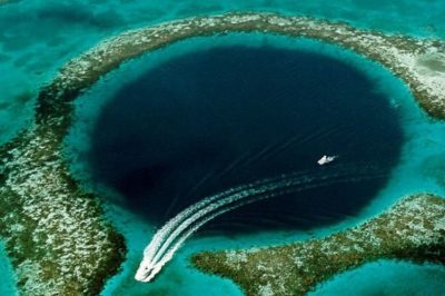 December 4, 2019 Great Blue Hole: Largest Underwater Sea Hole off the coast of Belize is a Diver’s Paradise
 April 14, 2019 Fingal’s Cave: The Musical Geometry of Nature’s Domain
 December 18, 2019 Punta del Hidalgo Lighthouse: A Celebration of Modern Architecture and Traditional Utility
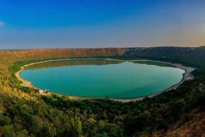 July 17, 2019 The Lonar Lake: An Astronomical Marvel
The post Incredible Snake Island: One of the Most Uninhabitable Places in the World appeared first on .
]]>The post Understanding Dictatorship – Why They Don’t Last and What Are the Early Signs of Dictatorship? appeared first on .
]]>• The democratic type of politics fails at proper governance, to deliver results, and to uphold governmental institutions.
• Too much political, financial, economic, and military power is consolidated in the hands of one person or party.
• The person or party has the fanatical support of a large group of devoted followers.
• The opposition is weak or fragmented and incapable of putting up a fight.
It is simplistic and incorrect to paint all dictators as evil, power-hungry people. Many of them, in fact, are or have been talented, charismatic people who start out with a strong desire to make a difference in their community or their country. They get involved in local and national governmental matters and are often forced into the top position after their country’s controlling institutions fall into disarray.
Why dictatorships do not last?
There is much-translated and much-disseminated Persian adage that states -“This too shall pass”. And that, in brief, is the reason why dictatorships—and many other forms of governments throughout human history—do not last.
Let’s look at some of the reasons:
1. Time, in the long run, is not in the favour of dictators. Few of them have successors as capable and influential as them, with the same public or military support, and, often, once a dictator dies, the dictatorship goes with it.
2. Dictators have to contend with changing circumstances, and the winds that ushered them into power can suddenly change directions and topple them. That may happen due to deteriorating economic conditions within the country and the inability of the dictator to rectify the situation. Or, because the people can no longer tolerate the dictator’s harsh domestic policies. An example of this was the mass public Strike of Fallen Arms in El Salvador in May 1944 that forced the Salvadoran military dictator, Maximiliano Hernández Martínez, to flee the country.
3. The world is an interconnected place, and it is impossible for any nation to exist in a vacuum. The domestic policies that a dictatorship implements and the way it treats its citizens can affect its international political standing as well as its business and economic relations with other countries.
Foreign powers can put pressure on the dictatorship and force it to follow a more rational course. Additionally, the public opinion formed abroad can affect the citizens and fill them with the desire to have the same rights and opportunities themselves, and inspire them to take action to bring about the political and social changes they desire.
4. It is also essential to mention the issue of covert interference on the part of foreign governments in a country’s national affairs. They may fund and support the opposition to the dictator and play a role in bringing about his downfall. Of course, the reason for wanting the dictatorship to topple is not so much a matter of human rights than the more cynical purpose of getting unimpeded access to the nation’s natural resources.
However, if foreign powers consider a dictatorship useful for their agenda, they will support it over the desires of the citizens of that country.
The early signs of a dictatorship
The Athenian statesman, Solon, who lived from 630 BCE to-560 BCE, informed his countrymen of coming despotism in elegiac verse, warning them that their ignorance would lead them into bondage, and they must act to save their democratic institutions before it was too late. His advice, of course, went unheeded. People don’t learn from history, and that is why historical patterns keep repeating.
Here are some early signs of dictatorship:
Controlling the media
Controlling the flow of information in the country is a common method by which the administration can control and shape the social and political narrative. The press may be reduced to little more than a propaganda organ for the administration. Additionally, it may engage in tactics such as attacking the opposition with well-worn terms like anti-nationals or traitors, and it may distort and misreport the news, or blatantly lie.
The journalists and reporters that don’t go along with the official line may stand to lose their jobs or be discredited professionally. In some cases, they may also risk being assaulted. The administration may gradually curb public freedom of expression by harassing, arresting, and imprisoning dissenters.
Rigging the election system
While the party/government may hold elections to keep up a facade of the democratic process, the election outcome may be pre-determined by the rigging of Electronic Voting Machine (also known as EVM) or the manipulation of paper ballots. Sometimes, the government may make threats or offer bribes to get people to vote for particular candidates. It is also possible that it may threaten opposition candidates and force them to step down or be directly or indirectly involved in assassinating them, leaving the field open for the dictatorship.
Browbeating the judicial system
The party/government may bring personal and professional pressure on judges to force them into passing judgments according to its diktat. For example, it may require them to give lenient sentences to party cadres and give clean chits to politicians accused of bribery, extortion, and rape. It may also require them to misuse the legal system to embroil the opposition in real or fabricated legal troubles.
Spying on the population
The party in power may set up surveillance systems to monitor most aspects of the citizens’ public lives, including what they do, where they go, who they interact with, and what they talk about, read, or post on social media. The information may then be used against the citizens if they step out of line or criticize the administration.
Punishments may range from smearing their characters and publicly shaming them to summoning them to the police station to explain themselves. It is possible that the targeted citizens may be accused of offending public sentiments and committing other thought crimes. They may be labelled as anti-national or urban terrorists.
Harassing students and intellectuals
The government may make education expensive, and, at the same time, cause the quality of education to deteriorate. It may keep a close watch on well-known student leaders and on those students that have been determined to be troublemakers or agitators. If there is any trouble, it may arrest these students and quell the rest of the protest.
Intellectuals may receive similar or harsher treatment. The government may place them under house arrest or refuse them permission to address the public.
Suppressing civic rights
Along with spying on them, the government may suppress the civil rights of the citizens. It may ban them from using smartphones, from going online, and from using public facilities. It may freeze their bank accounts and make it difficult for them to hold a job. Additionally, it may ban them from travelling abroad and from having any contact with the media. Furthermore, it may extend such punishments to the friends and families of the offenders in order to create an atmosphere of fear and bring about social ostracization.
Promoting civil unrest
The administration may resort to promoting civil unrest among the citizens in order to prevent a unified opposition against it. For this, it may attempt to pit people against each other on religious, racial, and ideological grounds. It may engage in spreading rumours and announce policies that are likely to provoke certain communities. It may send provocateurs among gathered crowds to incite violence. Sometimes, the government may also stage violent false flag incidents like riots, shootings, and bombings, and put the blame for these events on the public. It may then use the events as a pretext for unleashing the police and the military to curb the protests.
Examples of some lesser-known dictators and their fate:

Kurmanbek Bakiyev. (Steele C. G. Britton, U.S. Air Force)
Name: Kurmanbek Bakiyev
Location: Kyrgyzstan
Ideology: Authoritarian
Reign: 2000-2002 and 2005-2010
Aftermath: After the outbreak of violent protests in Bishkek against his authoritarian policies, corruption, and rising utility costs, Bakiyev fled to Jalal-Abab on 8 April 2010. Although he refused to step down, he could not prevail against the opposition and departed for Kyrgyzstan on 15 April 2010. He remains in exile.

Hideki Tojo. (Wikimedia Commons)
Name: Hideki Tojo
Location: Japan
Ideology: Militarism/Totalitarianism/Fascism
Reign: 1941-1944
Aftermath: Tried by the International Military Tribunal for the Far East and executed by hanging for war crimes on 23 December 1948.

Ferdinand Marcos. (U.S. Army)
Name: Ferdinand Marcos
Location: Philippines
Ideology: Republican Nationalism/Fascism
Reign: 1972-1986
Aftermath: Rigged elections to win against opposition presidential candidate, Corazon Aquino, on 7 February 1986. After the resultant nationwide protests, he fled to Hawaii on 25 February 1986. He remained there in exile until his death on 28 September 1989.

Ion Antonescu. (National Digital Archive)
Name: Ion Antonescu
Location: Romania
Ideology: Fascism
Reign: 1940-1944
Aftermath: Defeated by King Michael’s Coup d’etat in August 1944, charged with war crimes and sentenced to death by the Romanian Communist People’s Court, and executed on 1 June 1946.

Benito Mussolini, the founder of Fascism and Hitler’s World War II ally. (Wikimedia Commons)
Name: Benito Mussolini
Location: Italy
Ideology: Fascism
Reign: 1925-1945
Aftermath: Executed by Italian partisans on 28 April 1943, alongside his long-time mistress, Clara Petacci. Their bodies were desecrated and hung upside down in Milan’s Piazza Loreto.
Benevolent Dictatorship
Benevolent dictatorship, which is also sometimes known as enlightened despotism, is the authoritarian rule of one person or party that seeks to exercise absolute political power to bring about social and economic reforms.
Here are three examples of a benevolent dictatorship.
Sultan Qaboos bin Said of Oman
Sultan Qaboos bin Said of Oman is the longest-reigning ruler in the Middle East. He seized power in Oman on 23 July 1970, after ousting his father, Sultan Said bin Taimur, with the assistance of the British military.
Using oil revenues, he then proceeded to transform Oman from an impoverished state into a modern nation with highly developed infrastructure, healthcare, and education systems.
Lee Kuan Yew of Singapore
Lee Kuan Yew served as the first Prime Minister of Singapore for 30 years, from 1959 to 1990; as a Senior Minister from 1990 to 2004; as a Minister Mentor from 2004 to 2011; and as Member of Parliament for Tanjong Pagar Group Representation Constituency from 2011 to until his death in 2015 at the age of 91. For nearly 56 years, he retained complete parliamentary control of Singapore.
Along with his focus on upholding meritocracy and rooting out corruption, Lee Kuan Yew invited foreign investment, built manufacturing plants, and developed Singapore economically. The country transformed within one generation into a first-world economy.
France-Albert René of Seychelles
France-Albert René, who died on 27 February 2019, served as the second Prime Minister of Seychelles from 1976 to 1977, and, after a coup d’etat, as the second President of Seychelles from 1977 to 2004. Although he stepped down in 2004, he remained the leader of the ruling Seychelles People’s Progressive Front party. During his tenure, due to extensive government funding in education, healthcare, tourism, and fishery, Seychelles became one of the most progressive countries in Africa. It also retained its political stability, despite CIA-funded attempts to topple the government.
Author’s Opinion
It is easy to look back on history and think that will never happen here. However, as history itself proves, dictatorships can happen anywhere there is little civic engagement and much public ignorance.
Enjoyed this article? Also, check out “Ivan the Terrible: The First Tsar of Russia and His Reign of Terror“.
Fact Analysis:
STSTW Media strives to deliver accurate information through careful research. However, things can go wrong. If you find the above article inaccurate or biased, please let us know at [email protected].
RELATED
 May 21, 2020 Yes, we need a global investigation into Covid-19 origin, but not for scoring trivial political points
 August 1, 2018 Super-Trains of the Past: Trains with Jet Engine
 July 13, 2018 Hanns Scharff: The Extraordinary Interrogation Technique of a Nazi Interrogator
 May 16, 2019 What is a Micronation? and Some of the Most Popular Micronations in the World
The post Understanding Dictatorship – Why They Don’t Last and What Are the Early Signs of Dictatorship? appeared first on .
]]>The post The Superstition Mountains and the Legend of the Lost Dutchman’s Gold Mine appeared first on .
]]>
The praying hand’s formation at the Superstition Mountains range. (Doug Dolde / Wikimedia Commons)
On the east side of Phoenix in Arizona lies the spectacular range of the Superstition Mountains that straddle the Tonto National Forest and the Superstition Wilderness area. They are bound on three sides by U.S. Route 60, Arizona State Route 88, and Arizona State Route 188, and are visible from miles away.
While popular with campers, hikers, and adventure seekers, these mountains are also known for their exceedingly hot summers, freezing winters, harsh winds, unpredictable storms, treacherous terrain, and mysterious happenings. Reports of inexplicable sounds, sightings, and events have led to claims of supernatural beings and even aliens. Combine these with the legends of the indigenous Pima Indians and the mountains live up to their name.
Among the many legends to have emerged from the area, one of the most enduring ones is that of The Lost Dutchman’s Gold Mine. Supposedly a mine with fabulously rich gold deposits. Many people have died trying to find it over the years, and, even with all the modern technology at our disposal today, the exact location of the mine in the vast wilderness still remains an enigma.
The Superstition Mountains
Superstition Mountain has an elevation of 5,024 feet. These steep, jagged volcanic mountains were formed over 29 million years ago and they cover an area of 160,000 acres. As the mountains have a desert climate and few water resources, there is not much vegetation here.
At the low elevations, you will encounter tall saguaro cactus and Ponderosa pines at higher levels, and these are generally near the streams. Animals like deer coyotes, pumas and bobcats live here, existing alongside birds, rodents, snakes, and other reptiles.

Saguaro cactus. (Circe Denyer)
The weather in the Superstition Mountains is notoriously unpredictable, with storms seeming to come out of nowhere and accompanied by abrupt drops in temperatures.
Two prominent landmarks here are the Weaver’s Needle and the Miner’s Needle. These are tall, volcanic formations in the wilderness and are popular as hiking destinations. There are numerous hiking trails that hikers can access from multiple points, one of the more well-known ones being the Peralta Trailhead.

Weaver’s Needle, a peak located in the Superstition Mountains. (Chris J / Flickr)
Legends of the Superstition Mountains
The Pima Indians famously feared the mountain that they knew as Ain-we-gophon (Superstition Mountain). According to their folklore, the mountain guards an ancient storehouse of precious metals and treasures, and anyone who ventures forth to get the treasure is likely to die.
According to the Apaches (North American Indians), the entryway to hell is in the Superstition Mountains. The mountain is also frequented with mysterious sounds that many people have claimed to have heard. The hellhole supposedly also sends out tremendous winds, and these cause the infamous dust storms of the region.
The Superstition Mountains, furthermore, are the abode of the Thunder God, and he causes the frequent regional thunderstorms.
There’s gold in them thar hills
There are many stories about hidden gold in the Superstition Mountains, and these usually mention the Peralta Family.
Don Miguel Peralta was the head of a powerful and wealthy Mexican family from Sonora, and they were either ranchers or operated mines or did both. They either mined or found enormous gold deposits in the Superstition Mountains. The stories differ from here onward.
According to some storytellers, in September 1848, a band of Apaches slaughtered the entire Peralta Family, except one (someone had to live to tell the tale). The Apaches were either enraged over the violation of their sacred mountains or wanted to steal the gold from them. Other storytellers claim that the Peralta Family escaped with gold, but another family died in the massacre. In any case, the event led to the naming of the Massacre Falls after it.
In the version in which the Apaches killed the Peralta Family, the surviving member then went on to get embroiled in a brawl fight years later. Two prospectors saved his life and, in gratitude, he gave them directions to the gold mine, thus setting off a wild goose chase that continues to the present day.
Doctor Abraham Thorne’s visit to the mine
A doctor from Illinois, Doctor Abraham Thorne, provided his service to treat the indigenous people of the Southwest. After he had spent many years in their midst, the Apache Elders decided to reward his selfless service with gold. In the year 1870, with his consent, they blindfolded him and took him on a 20-mile trip to an unknown location piled with gold ore. They removed his blindfold and let him take away as much as he could carry. Thorne sold the ore for $6000 and became a wealthy man.
Later, he remarked that he had noticed a towering rock formation nearby, but otherwise remained clueless about the whereabouts of the place. Many people took the landmark to be the Weaver’s Needle but had no luck finding any gold nuggets in its vicinity.
The Peralta Stone maps
Travis Tumlinson, a policeman, discovered the Peralta Stones on a roadside near the Superstition Mountains in the 1940s. These are rectangular, cross-shaped, and heart-shaped stones with etchings of a horse, a priest, a dagger, a trail, topographic features, and Spanish inscriptions. It is rumoured that if the stones are put together in the right way, they are a map to the Peralta Family’s gold deposits. Nobody has been able to interpret them correctly.

Front View of the Peralta Stones. (Latin Heart Reader / Wikimedia Commons)
The legend of the Lost Dutchman’s Mine
To begin with, there was never any real Dutchman involved with the lost gold mine. The closest approximate was a German miner of the Pennsylvania German community. When they immigrated to Pennsylvania from Deutschland (Germany), the locals mistook Deutsch for Dutch. The newcomers, thus, became the Pennsylvania Dutch.
Two Pennsylvania Dutchmen, Jacob Waltz and Jacob Weiser, were prospecting for gold in the area, when, one night, they happened to save a man’s life in a bar brawl. He turned out to be the surviving Peralta, and, to express his gratitude, he gave them directions to his family’s gold mine in the Superstition Mountains.
The two Jacobs found the gold but refused to tell anyone else where it was. Then the Apaches killed Jacob Weiser, or according to some, Waltz himself did it.
Jacob Waltz took to returning to the mountains only when he needed the gold. He died of pneumonia in 1891 and, according to the three neighbours who cared for him, he left them the box of gold under his bed and directions to the gold mine.
The neighbours—Julia Thomas, Rhinehart Petrasch, and Hermann Petrasch—spent weeks looking for the gold, but failed to find it.
Mysterious disappearances in the Superstition Mountains
The legend of the lost gold continued to attract people, and, in 1932, a veterinarian in the Park Service, Adolph Ruth, decided to go treasure hunting. He had acquired maps that he was sure would lead him straight to the gold. Instead, he went missing and his skull was found 6 months later with two large circular holes. The rest of his remains were found a month later about a mile away.
A note in a bottle found floating down the Salt River said that he needed help on account of his leg and that he had found the Lost Dutchman’s gold mine. To underline his great find, he had also written ‘Veni, Vidi, Vici’ (I came, I saw, and I conquered) in his diary. However, there were no directions to the conquest mentioned in his diary.
Many other mysterious deaths in the Superstition Mountains followed that of Ruth’s in the subsequent years, including two soldiers from the U.S. Army. And, amazingly, a few of these people were also found in the same headless state as Adolph Ruth. The search, nevertheless, still continues.
The Superstition Mountains in popular culture
There have been many books, films, and cartoons about the Lost Gold of the Superstition Mountains. These include Barry Storm’s book Thunder God’s Gold, published in 1945, detailing his own efforts to find the gold, and the Glen Ford and Ida Lupino movie, Lust for Gold, from 1949.
Hanna-Barbara, Jean Giraud, and Don Rosa have incorporated the story in their cartoons. The Lost Dutchman State Park, which opened in 1977 and has the Peralta Trail, is also a nod at the legend.
There is a Superstition Mountain Museum at 4087 N. Apache Trail, Highway 88 in Apache Junction. It is open daily from 9 a.m. to 4 p.m. except on Thanksgiving, Christmas, and New Year.
Fire in the Superstition Mountains
On 8 June 2019, a fire broke out in the Superstitions Wilderness area and soon spread across 26,000 acres. It was the fifth-largest fire in Arizona’s history, it raged for over a month, despite the strenuous containment efforts of over 600 firefighters. Due to the out-of-control fire, the Arizona authorities were forced to close the State Route 88, and, along with it, public access to the Canyon, Apache Lake, Apache Campground, picnic sites, and trailheads.
Fact Analysis:
STSTW Media strives to deliver accurate information through careful research. However, things can go wrong. If you find the above article inaccurate or biased, please let us know at [email protected].
RELATED
 May 1, 2019 Devils Tower in Wyoming: A National Monument and a Geological Wonder
 August 31, 2020 Ennedi Plateau and Aloba Arch: Home to Exquisite Natural Formations and ‘Extinct’ Animals
- April 14, 2019 Fingal’s Cave: The Musical Geometry of Nature’s Domain
 March 23, 2019 The Moeraki Boulders of New Zealand: Naturally Formed Spherical Boulders from the Paleocene Era
The post The Superstition Mountains and the Legend of the Lost Dutchman’s Gold Mine appeared first on .
]]>The post The Time Pyramid of Wemding: A Pyramid That is Scheduled for Completion in 3183 appeared first on .
]]>
Time pyramid in Wemding, Germany. (JuSt-Wemding / Wikimedia Commons)
The Time Pyramid, known in the German language as Zeitpyramide, is a public artwork project that has been a work-in-progress in the German town of Wemding since 1993. Manfred Laber, a local artist, conceived the idea of building this pyramid to commemorate the 1200th anniversary of the establishment of the town. As per Laber’s plan, the Time Pyramid is going to take another 1200 years to complete. The artist’s hope is that this deliberately long drawn out construction will help the present generation and the future ones to understand the significance of a very long span of time.
The town of Wemding
Wemding is located in Bavaria’s Donau-Ries district, on the edge of a meteorite impact crater formed in the Miocene Age many millions of years ago. Established in 793, it is a charming town with many historic sites. It is well-known for its rose gardens and its fuchsias that make for a beautiful sight in the spring and summer. It is also now known for the Zeitpyramide.
It is perhaps the only town in the world that is building such a pyramid, and the project is likely to bring it more revenue from increased tourism. A foundation based in Wemding is overseeing the building of the Time Pyramid, and the funds for the project have so far come from generous contributions made by local businesses.
The idea behind the Time Pyramid
The premise of the Time Pyramid is that the builders will lay a single concrete block for its structure every ten years. If everything goes according to schedule and if future generations remain cooperative about continuing to work on the project, the pyramid will be completed in 3183.
The concrete blocks for the Time Pyramid

Design of the Time Pyramid. (Cmglee / Wikimedia Commons)
The builders selected concrete blocks as the most cost-effective materials for the construction of the Zeitpyramide. However, it is possible that future generations, if they find it worthwhile to keep building the pyramid, may use stone or other materials not yet known.
Each of the concrete blocks for the Zeitpyramide are to be around 4 feet in length, 4 feet in width, and 6 feet in height. The first block was put in place in 1993, the second in 2003, and the third in 2013. In total, there are to be 120 blocks that will make up the entire pyramid, and each of these blocks weighs several tons.
Possible issues with the completion of the Time Pyramid
While planning to construct a Time Pyramid across a span of 1200 years, the builders, of course, expect the structure to last that long. However, it is essential to consider if the concrete blocks used to build the Time Pyramid will be able to stand the test of time.
Since concrete is a porous material, water can soak through it. Over time, the water seepage will corrode the reinforcing steel bars and meshes used inside in the construction of the concrete blocks. That will result in minor cracks and these will soon expand and may even cause the blocks to break.
The cyclical freezing and thawing that occurs seasonally in the Bavarian region can have a particularly ruinous effect on the concrete. To prevent the concrete blocks from weakening and breaking over time, it may help to an extent to get the blocks specially treated with sealants. They will then be better able to withstand the effects of the weather.
In the construction industry, sealants such as sodium acetate are commonly used to increase the lifespan of concrete blocks. However, few buildings are constructed with the idea of lasting for 1200 years. There is no way of knowing if the currently used concrete sealants will be able to retain their protective capacity for such a long duration. Perhaps, though, there might be better materials in the future that might be used for sealing the concrete blocks. That is, if later builders continue to use concrete as the building material.
The Time Pyramid
The Zeitpyramide is being built on the Robertshöhe hill that is to the north of Wemding. The builders have created a concrete base and the Time Pyramid will come up on this.
While nobody currently alive will be around to see the completed pyramid in 3183, they can still get an idea of what the completed pyramid will look like by seeing the exhibited model of it at the Haus des Gastes in Wemding.
The pyramid will have a base tier and four tiers thereafter. The base tier will have 64 blocks placed in eight rows and eight columns in a 45 feet by 45 feet area. It will take until 2623 to complete the base tier and by this time, Wemding will already have had its bi-millennial anniversary.
The second tier will be completed in 2983 and will have 36 blocks that will be arranged in a 6 by 6 format. These blocks will be placed on top of other blocks. Given how heavy the concrete blocks are, it will be necessary to use a crane to lift them and place them in the right positions.
Comprising of 16 blocks that will be arranged in a 4 by 4 format, the third tier will be completed in 3143. The fourth and final layer, which is to have 4 blocks arranged in a 2 by 2 format, will be done in 3183.
The adjacently placed blocks of the Zeitpyramide will be separated from one another by a distance of two feet. So, close up, visitors will only see stacked concrete blocks. It is only when they step back that they will be able to see the pyramidal shape.
Building pyramids is not a new idea in human history, but the concept of building a Time Pyramid that spans centuries is quite a first. It would be interesting to know what the people of the future think of it.
Enjoyed this article? Also, check out “The Tjentiste War Memorial: A Commemoration of Those That Died in the Battle of Sutjeska“.
Fact Analysis:
STSTW Media strives to deliver accurate information through careful research. However, things can go wrong. If you find the above article inaccurate or biased, please let us know at [email protected].
RELATED
 July 21, 2019 The Tjentiste War Memorial: A Commemoration of Those That Died in the Battle of Sutjeska
 July 27, 2019 Wind in the Willows: The Singing Ringing Tree
 October 16, 2019 Old Man of the Lake: The ‘Stumping’ Story of a Century-Old Log, Bobbing Inexplicably in Oregon’s Crater Lake
 January 19, 2019 The Seven Wonders of the Ancient World and the History Behind It
The post The Time Pyramid of Wemding: A Pyramid That is Scheduled for Completion in 3183 appeared first on .
]]>The post Solifugae: Unique Creatures That Are Neither True Scorpions Nor True Spiders appeared first on .
]]>
Solifugae: A Sun Spider in Merida, Yucatan, Mexico. (Maximilian Paradiz / Flickr)
Solifugae are strange-looking creatures and, despite many studies, there is still much about their physical attributes and behaviours that we don’t know.
The name solifugae has Latin roots and means those that run away from the sun. It is a reference to their nocturnal habits. The creatures are also known as camel spiders, wind spiders, wind scorpions, sun scorpions, sun spiders, red romans, baardskeerder, and haarskeerders. The last two are Afrikaans terms for beard cutters and hair cutters.
Solifugae: Neither True Scorpions Nor True Spiders
Solifugae look like they might be a cross between spiders and scorpions, but, actually, they are a distinct species with over 1000 varieties in 153 genera. They are members of the Arachnida class and belong to the superorder Haplocnemata; they and the Pseudoscorpiones order are the only teo members of this superorder.
At first glance, though, solifugae do resemble spiders in physical appearance. The brownish-yellow or mottled solifugae body has two tagmata that consist of an abdomen known as opisthosoma and a prosoma, which is a combination of head and thorax and is also known as cephalothorax. There is no third tagma that forms a tail as is the case in scorpions, and they also do not have poison glands to produce venom.
Physical Appearance of Solifugae
The posterior opisthosoma has ten segments and the anterior prosoma has two segments. The prosoma has a prominent, arch-shaped plate—which is why these creatures are also known as camel spiders—and a pair of central simple eyes and a pair of lateral ones. There is no pedicel separating the prosoma and the opisthosoma as there is in spiders. Solifugae also do not have spinnerets like spiders and do not spin webs, and so do not need to have mobile abdomens like spiders do to use for their spinning activities.
There are six pairs of appendages that arise from the somites on the prosoma, but these are not all actual legs.
The first pair are the pedipalps that barely touch the ground while the solifugae are walking or running, and function more like antennae to detect things in their path. The five-segmented pedipalps have adhesive organs that are reversible and are used for climbing, defence, and to catch flying prey.

A sun spider in Circulo Montana, Arizona, USA. (ALAN SCHMIERER / Flickr)
Then there are the conspicuously large, distinctively curved chelicerae. Each of these have two articles that form powerful, crab-like pincers and, depending on the species, have a variable number of teeth. Using these chelicerae, solifugae can cut through hair, feathers, skin, and thin bones. They also use them to make rattling sounds to warn off enemies or attract potential mates.
Only the posterior three appendage pairs are real legs. They are each made up of seven segments. Two of these segments, the coxae and the trochanters, have fan-shaped organs known as malleoli on their undersides. The solifugae can turn the malleoli blades forward and backward, but the exact function of these organs remains unknown. The surmise is they may have a sensory use to detect prey, potential mates, threats, and ground vibrations. The other segmented parts of the real legs are femur, patella, tibia, metatarsus, and tarsus.
Using the real legs, the solifugae can attain speeds of 16 kilometres per hour, probably making them the fastest invertebrates on land.
Since the solifugae don’t have book lungs, they use their tracheal system to breath through three slit pairs that are located on the underside of the opisthosoma. Pseudoscorpiones also have the same breathing system.
Lengthwise, there are size variations in different solifugae species. Some mature specimens can grow up to 12 to 15 centimetres in length, while others are five to seven centimetres and some are under one centimetres.
Regions where Solifugae are found
While it is commonly assumed that solifugae are desert dwellers, they actually occur in a range of environments. Aside from deserts, semi-deserts, and scrubland, they occur in mountains, forests, and grasslands. They generally prefer warm temperate and tropical regions, and are widely found in Africa, Asia, the Americas, and Southern Europe. There are no solifugae in Antarctica, New Zealand, and Australia.
Diet of Solifugae
The diet of the solifugae principally consists of termites, beetles, and other small arthropods. They also feed on small lizards, rodents, snakes, birds, and other creatures. They are fast-moving and ferocious predators and most of them emerge out of their semi-permanent burrow only at night. They locate their preys with the pedipalps and use the chelicerae to grab the prey and cut it to pieces. They then liquefy the prey and use their pharynx to consume it.

The pedipalps of sun spider. (ALAN SCHMIERER / Flickr)
The solifugae are not dangerous to humans. They don’t have any venom to poison you with, and, for all their fabled speed, they are not going to outrun you. However, they can and will inflict painful cuts with their chelicerae if you get too close.
Lifecycle of Solifugae
The sexes are separate in the solifugae, and they reproduce by direct mating or by engaging in indirect sperm transfer. In the latter reproduction method, the male solifugae releases a spermatophore. He then uses his chelicerae turn the female solifugae on her back and inserts the spermatophore into her genital pore.
Since the solifugae are oviparous, the female solifugae will then, after a while, 50 to 200 eggs into a burrow. In some species, the female solifugae will eat extensively and fatten up prior to laying the eggs. She will then stand guard on the eggs and remain there, without eating, until they hatch.
The solifugae develop without metamorphosis. The postembryo that will emerge from the eggs will transform into nymphal instars and then develop into adult solifugae.
They have a lifespan of one to two years.
Enjoyed this article? Also, check out “Insects from Hell: Mecoptera, the Fly with a Scorpion Tail“.
Fact Analysis:
STSTW Media strives to deliver accurate information through careful research. However, things can go wrong. If you find the above article inaccurate or biased, please let us know at [email protected].
RELATED
 September 16, 2019 Maned Wolf: The Existential Crisis of Chrysocyon – the Golden Dog That Looks Like a Fox
 November 4, 2019 Goblin Shark: The Alien Shark of the Deep Sea, with a Slingshot Mouth
 October 4, 2019 The Extraordinary Exocoetidae – The Flying Fish of the Tropics and Subtropics
 April 8, 2019 The Manchineel Tree: One of the Most Toxic and Dangerous Tree in the World
The post Solifugae: Unique Creatures That Are Neither True Scorpions Nor True Spiders appeared first on .
]]>The post Paranormal Sightings in England: The Brown Lady of Raynham Hall appeared first on .
]]>Raynham Hall
Built in the 17th century by Sir Roger Townshend, his descendants still own and live in this magnificent neoclassical house. While the design of the house was inspired by the work of the architect Inigo Jones, Sir Roger Townshend implemented most of his own architectural ideas. As he incorporated the styles he liked, the house has a unique appearance. The structure is Jacobean and overlaid with classical Georgian style, and the exterior curving gables are inspired by the Dutch-influenced designs of East Anglia.

Raynham Hall in Norfolk, England. (John Fielding / Flickr)
In the 18th century, Charles, the 2nd Viscount Townshend, hired designer William Kent to refurbish the interior with an understated elegance that has made the interior as stunning as the exterior. For all its grandness, though, Raynham Hall is primarily a family home, and many visitors have remarked on its welcoming and harmonious atmosphere. At the same time, the manor is said to be haunted.
The Brown Lady of Raynham Hall
The spectre haunting Raynham Hall is said to be of Dorothy Walpole, the second wife of Charles Townshend, and the sister of Robert Walpole, the first Prime Minister of Great Britain.
Born on 18 September 1686 to a wealthy landowning family, Dorothy Walpole grew up in the family home at Houghton Hall in Norfolk. She fell in love with Charles Townshend, her father’s ward, when she was only 10 or 11 years old. As she was too young, her father forbade the match, and Charles Townshend went on to marry someone else.

Portrait of Lady Dorothy Walpole. (Wikimedia Commons)
Later, after the death of Charles Townshend’s first wife, Dorothy married him in 1713, and the couple had seven children in the course of their 13-year long marriage. Charles Townshend had risen up to be a Whig politician who served for ten years as Secretary of State. He was known to have a violent temper.
As a young woman, Dorothy Walpole had a flirtation or an affair with the notorious philanderer and Whig politician Lord Wharton.
According to rumor, he learned of his wife’s long-ago indiscretions with Lord Wharton much later in their marriage. Incensed at being kept in the dark for so long, he locked her up in her room and refused to let her have any contact with their six surviving children.
The incarcerated Lady Townshend died at the age of 40 on 29 March 1726, reportedly of smallpox. However, there were rumours that Charles Townshend pushed her down the main staircase in a fit of rage, and this is why her ghost appears on this stairway.
Sightings of the Brown Lady of Raynham Hall
The first intimation of a ghost at Raynham Hall came during a Christmas gathering in 1835. Among Lord Charles Townsend’s guests were two men named Colonel Loftus and Mr. Hawkins. As they were returning to their bedrooms after the evening’s festivities, they claimed to have encountered an aristocratic-looking lady in an old-fashioned brown dress on the main stairway. They wouldn’t have thought anything of the encounter, except when the lady looked at them, they saw she had empty eye sockets, and there was an unearthly glow in her face.
Loftus saw her the following evening as well and was struck once more by her empty eyes. He even drew a sketch of the apparition, and that led others to claim they had seen her as well.
A year later, the well-known author Frederick Marryat decided to test the truth of the Christmas ghost sighting and, so, the Townshends accommodated him in the haunted room. For two nights, there was no ghostly activity, and Marryat began to think that perhaps he had been right in his original assumption that the haunting story was nothing more than a gimmick by local smugglers to keep people away from the area.
He changed his mind the following evening.
As he was retiring to bed for the night, Townshend’s two nephews knocked on his door and invited him to come and see their new gun which had just arrived from London. Afterwards, the two young men accompanied Marryat back to his room, joking about protecting him from ghostly apparitions. Right then, they saw a light in the corridor ahead and thought it was one of the guest ladies going to check on their children in the nurseries. Embarrassed to be seen by a lady in just his shirt and trousers, Marryat quickly stepped into a nearby room and waited for the candle-bearer to pass on.
The woman drew closer, and, looking out through the ajar door, Marryat was astonished to see that she was wearing the old-fashioned brown dress that the ghost had reportedly been seen in. His hand went instantly to his revolver, and he opened his mouth to call for the figure to stop right there. At that very instant, the apparition turned and looked directly at him and gave him a ghastly, malicious smile.
Reacting instinctively, Marryat fired his revolver at the ghost. The Brown Lady vanished instantly, to the astonishment of all three men. However, they later found the bullet lodged in the wall of the room across the corridor.
The photograph of the Brown Lady of Raynham Hall
In 1936, a photograph named Captain Hubert C. Provand and his assistant Indre Shira, working for Country Life magazine, arrived at Raynham Hall to photograph the interior. On 19 September 1936, they set up the camera in front of the main stairway and began taking photographs. Just then, Indre Shira noticed something coming down the stairs and realized it was the Brown Lady of Raynham Hall. He quickly alerted Provand to this fact, but the latter was unable to see the ghost. However, acting on Shira’s directions, he turned the camera to where Shira was pointing and took a photo.

The famous photo of Brown Lady of Raynham Hall. (Wikimedia Commons)
When they developed the photograph, it showed a misty apparition coming down the staircase. It is the only known photograph of the Brown Lady of Raynham Hall.
Controversies about the photograph of the Brown Lady of Raynham Hall
The photograph created a sensation when published in Country Life magazine in December 1936 and Life Magazine in January 1937. For many paranormal investigators, it was a vindication of their belief in the existence of supernatural spirits. One of them, an investigator named Harry Price, interviewed Provand and Shira and reported that he found their accounts quite trustworthy.
On the other hand, several photographers and investigators of paranormal activities expressed doubts about the photograph’s authenticity. According to some of them, the luminous blur in the photograph was a simple case of double exposure. Others claimed that it was a case of superimposing an image of the Virgin on a photograph of the stairway.
There have also been doubts about the ghost being of Dorothy Walpole and even on the manner of her death. There are contemporary accounts that refer to her as an elegant, accomplished, and well-liked woman and to Townshend as a man of honour and integrity. The general impression seems to have been that the Townshends had a reasonably amicable marriage. As such, the image of an evil-tempered husband and an abused wife doesn’t quite fit.
Whatever the truth, the legend of the Brown Lady of Raynham Hall persists to the present time.
Enjoyed this article? Also, check out “Helen Duncan: The Last Witch of Scotland“.
Fact Analysis:
STSTW Media strives to deliver accurate information through careful research. However, things can go wrong. If you find the above article inaccurate or biased, please let us know at [email protected].
RELATED
 November 6, 2018 The Haunting Visage of the Belmez Faces: An Anecdote of Lost Souls or Purported Skullduggery?
 August 22, 2019 La Pascualita: An Extremely Well-Preserved Corpse, or an Eerily Life-like Mannequin?
 August 6, 2018 Story of Robert the Doll: The Alleged Haunted Doll That Receives Letters Everyday
 July 11, 2018 Helen Duncan: The Last Witch of Scotland
The post Paranormal Sightings in England: The Brown Lady of Raynham Hall appeared first on .
]]>The post Victor of Aveyron – The Feral Boy from France appeared first on .
]]>
Artwork of Victor of Aveyron. (Gallica Digital Library)
Victor of Aveyron was a feral child discovered in the environs of Saint-Sernin-sur-Rance. While he attracted a lot of public attention at the time, attempts to civilize and integrate him into French society were not successful.
Discovering Victor of Aveyron
In 1794, the woodmen of Aveyron in France noticed a strange boy in the woods near Saint-Sernin-sur-Rance. He wore a ragged shirt and appeared to behave more like a wild animal than a human being, walking on all fours and foraging for food on the ground. The woodmen weren’t able to get near him, but saw him on several occasions during the next four years. In January 1800, they were able to capture him—or he approached them; there are conflicting stories about that—and found him to be completely feral and unaccustomed to being around human beings.
He appeared to be around 12 or 15 years old. Incapable of speech, he could only produce animal-like sounds, and, at first, he also seemed to be deaf. There was no way of knowing who he was or for how long he had been alone in the woods. There was some speculation that he might have been an illegitimate child and that his parents or caretakers had abandoned him on account of his obvious cognitive disabilities.
The authorities in Aveyron placed him in an orphanage and he sparked a great deal of public interest, but it was not easy to care for him. Dubbed the Wolf Child, he disliked being forced to wear clothes and tore them off at every opportunity. Pierre Joseph Bonnaterre, a naturalist, observed his behaviour and noticed that his mood brightened in sunlight. Also, when it snowed, he ran outdoors, tore off his clothes, rolled naked in the snow, and ate it by the handfuls. He appeared to be completely impervious to the cold, and also to the presence of humans, unless they had anything he could eat.
Attempts to rehabilitate Victor
After a few weeks in Aveyron, the authorities decided it might be better for the boy if they sent him to the National Institute of the Deaf in Paris. Although he wasn’t deaf, the experts there might be better able to care for him. There was much public debate at the time about whether it was morally right to try and civilize the boy or let him remain as he was.
At the Institute, the renowned instructor Abbé Roch-Ambroise Cucurron Sicard attempted and failed to instruct the feral boy in even the rudimentary social behaviours. The boy showed no sign of understanding anything he was taught and lacked all reasoning capacity. Doctors examined the boy and found that, while he was healthy and wasn’t deaf, he had faulty eyesight. Moreover, they discovered that he had poor coordination and showed signs of being severely mentally retarded. Declaring the boy to be a congenital idiot, Abbé Sicard washed his hands off him and allowed him to roam unhindered on the Institute’s grounds.
Victor of Aveyron and Itard
A medical student named Jean-Marc Itard took an interest in the young boy and decided to try and help him. He took him into his house, named him Victor, and appointed a woman named Madame Guerin to care for him.
Working tirelessly together, Itard and Madame Guerin attempted to socialize Victor by monitoring his daily activities for the next six years. It was an uphill task. As Itard discovered, Victor could not even differentiate between hot and cold sensations. Just as he rolled in snow without feeling the cold, he could dip his hand in boiling water without flinching to scoop out potatoes.
Itard and Madame Guerin had to use sensory stimulation training to make Victor understand the differences between hot and cold as well as the differences between wet and dry. They also accustomed him to wearing clothes, to eat with a spoon, and to being around people.
Once, to socialize Victor, Itard took him to a dinner gathering at a leading socialite’s home. The party was packed with people eager to see the feral boy, and he more than lived up to their expectations. After stuffing himself at the table and filling his pockets with the delicacies, he slipped away into the garden. Itard and the other noticed his absence only after they heard excited shrieks from the garden.
Running out there, they saw that Victor had shed most of his clothes and was speeding about happily across the lawns. As they watched, he ripped off the last remnant of clothing and clambered up a tree. He then proceeded to leap from tree to tree and ignored all the efforts of the scandalized guests to bring him down. He only came down after a quick-thinking gardener brought out a basket of peaches to tempt him.
Through repeated and patient attempts, however, Victor began to be more sociable around people. He began helping Madame Guerin with tasks around the house. He also showed empathy when her husband died; when he came across her weeping, he attempted to console her.
Along with socializing him, Itard attempted to teach Victor to speak, read, and write. There was a limited success here as well. Victor learned to speak only three works—eau (water), lait (milk), and O Dieu (Oh, God)—but did much better with recognizing shapes and letters. He also began to comprehend gestures, and might have benefited from learning sign language; strangely, Itard did not attempt to teach him that.
Victor’s progress remained limited and Itard attempted to speed things up by subjecting him to electric shocks; it was an accepted form of treatment at the time. Unfortunately, far from improving, Victor became prone to flying into sudden rages and also began to show signs of developing epilepsy.
Coming to the conclusion that there was nothing much he could do to teach Victor, Itard stopped the treatments and the teaching sessions. Leaving him in Madame Guerin’s care, he moved on to work on other research projects. Victor lived with Madame Guerin until his death in 1828. He was 40 years old and had made no further developmental progress.
The idea of the noble savage
In the 18th century, many Europeans thinkers and philosophers began to examine and question the concept of civilization. For various reasons, they assumed that human beings were better off living untrammelled in nature than in the confinements of urban areas. They thought that primitive tribes had fewer social problems and were morally superior to civilized people. The idea of the noble savage captured the public imagination. According to this line of thought, people were born with inherently noble qualities, but it was the nurture they received that led to their moral downfall.
The case of Victor of Aveyron put a spanner in this notion. There was nothing noble about Victor. He was more to be pitied than taken as an emulative example. Most feral children, like Victor and Dina Sanichar from India, grew up neglected and isolated, and miss a critical period of language development that can never be recouped. As they can never overcome their severe developmental issues, these children can never fully integrate into society and few of them live out their full lifespans.
Enjoyed this article? Also, check out “Mowgli was Real: Dina Sanichar, the Indian Boy Raised by Wolves“.
Fact Analysis:
STSTW Media strives to deliver accurate information through careful research. However, things can go wrong. If you find the above article inaccurate or biased, please let us know at [email protected]
RELATED
 January 27, 2019 Madagascar Hissing Cockroach: An Unusual Wild Insect That Has Now Replaced Popular House Pets
 May 15, 2020 Assateague Island and Its Feral Horses
 August 30, 2018 Mowgli was Real: Dina Sanichar, the Indian Boy Raised by Wolves
 August 10, 2018 Balut: A Filipino Delicacy Not Many Have the Stomach to Digest
The post Victor of Aveyron – The Feral Boy from France appeared first on .
]]>The post Frederick Law Olmsted – Father of American Landscape Architecture appeared first on .
]]>
Frederick Law Olmsted. (Wikimedia Commons)
As one of the foremost landscape architects in the United States, Frederick Law Olmsted is often described as the father of American landscape architecture. Together with his partner, Calvert Vaux, he was involved in designing more than 500 iconic parks in the country, including Central Park in New York, the Boston Park System, and the Buffalo Park System.
Frederick Law Olmsted
Although Frederick Law Olmsted later became a towering figure in the landscape design arena, he had no formal training in that sphere. In fact, he did not even attend college. Most of his design learning happened on the job and from his extensive travels around the United States and abroad in Europe and China. He read widely and was influenced by the works of Johann Georg von Zimmermann, John Ruskin, William Gilpin, Humphry Repton, William Shenstone, and many others.
His unique design ideas also came from his intrinsic aesthetic sense and a deep love of nature that he had inherited from his father, John Olmsted. Growing up in Hartford, Connecticut, he had spent many of his childhood holidays travelling with his father in the picturesque locales of the North-eastern United States. Later, as an adult, he travelled in Europe and the formal gardens and parks he saw there made a great impression on him.
What set Olmsted apart from contemporary landscape designers was that he wasn’t merely focused on creating a visually appealing landscape. He wanted to design landscapes that moved the emotions of visitors and provided them with restorative relief. Towards this goal, he applied psychological principles to his landscape design.
Early life and career of Frederick Law Olmsted
Born on 26 April 1822, in Hartford, Connecticut, Frederick Law Olmsted belonged to a well-off, upper-class merchant family. He was a creative, hard-working student and, after graduating in 1838 from Phillips Academy, he intended to attend Yale College. However, his eyesight was affected by sumac poisoning and he had to give up on his college plans. He did attend a few science and engineering lectures at Yale after his eyesight improved, but he never took a formal degree.
For a few years, he tried his hand at different professions. He joined the merchant navy and worked for a year as an apprentice seaman, travelling all the way to China. He next managed a dry goods store for a while in New York. Later, in January 1848, his father helped him acquire a 125-acre farm Staten Island’s southern shore, and he named it Tosomock Farm and settled there until 1855 to practice agriculture.
In 1850, he took six months off to go on a walking tour in Europe with his brother and some other friends. His travels inspired him to write his first book ‘Walks and Talks of an American Farmer in England.’ Published in 1852, the book was well-received, and his descriptive writing skills brought him to the notice of the New York Daily Times.
After his farming enterprise went bust, the newspaper commissioned him to act as their correspondent in the Southern Confederate States. He travelled extensively and sent back insightful accounts of the local culture, farming, horticulture, gardening, and institutionalized slavery in those states. His report led to three books—A Journey in the Seaboard Slave States, published in 1856, A Journey Through Texas, published in 1857, and A Journey in the Back Country in the Winter of 1853-4, published in 1860.
Frederick Law Olmsted’s foray into landscape architectural work
In 1857, Olmsted became the Superintendent of Central Park in New York. He gained this position through the connections he had made while working as a journalist. He formed an acquaintance with the prominent landscape architect, Andrew Jackson Downing, and, through him, met the English architect, Calvert Vaux. Impressed with Olmsted, Vaux asked him to collaborate with him.
Together, they designed a landscape architectural plan called Greensward and submitted it in the Central Park design contest. The selection committee picked their design as the winning choice in 1858.
It was an auspicious start to a successful partnership that lasted until 1872.
Olmsted worked on the Central Project until 1861. At this point, he took leave of absence to serve with the United States Sanitary Commission as executive secretary. In this capacity, he was responsible for treating the Union army soldiers during the American Civil War. He left this position in 1863 to work as a manager at the Mariposa Estate, a gold mining venture near San Francisco in California. After that operation went bust, Olmsted returned to New York to rejoin Calvert Vaux and resume work on landscape design projects.
Between 1865 and 1873, they designed Prospect Park in New York. They also designed the Riverside community in Chicago. Other landscape design works included the park system in Buffalo between 1868 and 1876 and, in 1887, the Niagara Reservation at the Niagara Falls.
In 1883, Olmsted moved his family and his landscape architecture practice to Brookline, Massachusetts. He worked on designing the Emerald Necklace park system in Boston as well as the campuses of Stanford University, Smith College, the University of Chicago, and Wellesley College. He also designed the structures for the 1893 World’s Fair in Chicago and created eye-catching white fairground buildings in the Beaux-Art styles that won him much acclaim.
Frederick Law Olmsted’s landscaping concept
Rather than impose a pre-decided concept on a place, Olmsted was prone to studying the area’s natural features and planning his landscape design around these. All the elements in the landscape had to be subordinate to the whole picture, without standing out just for the sake of it. The plants and trees had to be natural to the region, non-invasive, low-maintenance, and planted in a natural manner. He did not favour ornamental groupings.
Due to this, there was nothing artificial or forced about his designs. Furthermore, thanks to the design simplicity and lack of unnecessary distractions, people didn’t consciously notice the design work. Rather, they felt so naturally immersed in the landscape that the experience was both soothing and restorative. It was exactly the effect he wanted.
The City Beautiful movement
Frederick Law Olmsted was majorly influenced by the City Beautiful movement that swept through US American cities from around 1893 till the Great Depression. The aim of the City Beautiful movement was to correct the damage wrought by the coming of the Industrial Revolution on US American cities.
The rapid growth of industries had led to an influx of workers from rural areas to the cities to work in the factories. That, predictably, created problems like overcrowding, unsanitary conditions, and spread of disease. It also led to civic problems such as social unrest, violence, labor strikes, government corruption, economic depression, and disease.
To address these issues and change the dismal state of the cities, many upper-middle-class women formed civic improvement societies between 1893 and 1899. Assuming that improving the living conditions would improve public morality, they proposed creating orderly cities with adequate water supply, proper sewage systems, and reliable urban transportation. They also wanted the cities to have open green places that would offer psychological relief to the workers who worked long hours indoors in the factories and, moreover, didn’t earn enough to afford vacations to the countryside.
Many US American cities, including Washington D.C., San Francisco, Detroit, Chicago, Denver, and Dallas, adopted the City Beautiful principles in their city planning.
Inspired by the City Beautiful Movement, Frederick Law Olmsted attempted to create soothing, restorative landscapes. As long as he could achieve that purpose, he wasn’t bothered about deviating from the then-prevalent tastes and fashions. It was on account of this originality that his landscape architecture has endured so well over the years.
Frederick Law Olmsted’s last years
His failing health forced Olmsted to retire in 1895 and leave his firm to his sons; their successors kept the firm going until 1980. As his condition deteriorated, Olmsted was admitted to the MacLean Hospital in Waverly, Massachusetts, and spent his last days gazing out on landscaped grounds that he had himself designed. He died on 28 August 1903, aged 81.
Many years after his death, the National Park Service bought Olmsted’s home and office, Fairsted, and turned them into a public museum, the Frederick Law Olmsted National Historic Site. His landscape architectural drawings and plans are at the Olmsted National Historic site, while his other work papers are at the Library of Congress.
Enjoyed this article? Also, check out “Amazon Spheres: An Unexpected Rainforest in the Amazon HQ at Seattle“.
Fact Analysis:
STSTW Media strives to deliver accurate information through careful research. However, things can go wrong. If you find the above article inaccurate or biased, please let us know at [email protected].
RELATED
 August 21, 2020 Noor Inayat Khan: Britain’s First Muslim War Heroine
- March 30, 2020 Dr. William Chester Minor: A Learned Lexicographer or a Meritorious Madman?
- October 5, 2019 Jim Corbett: A White Hunter Who Became Saviour of Tigers
 November 22, 2018 33 Thomas Street: Windowless Skyscraper in the Midst of Bustling New York City
The post Frederick Law Olmsted – Father of American Landscape Architecture appeared first on .
]]>The post The Extraordinary Exocoetidae – The Flying Fish of the Tropics and Subtropics appeared first on .
]]>
Flying fish in Lakshadweep. (Mike Prince / Flickr)
Known commonly as flying fish, the Exocoetidae are oceanic fish that are widely found in the tropics and the subtropics. They are renowned for their ability to launch out of the water and glide in the air to escape predators. With their streamlined bodies and wing-like fins, these small fish can cover extensive distances, some of several thousand feet, while they are still air bound.
The Exocoetidae – flying fish
The word Exocoetidae comes from the Greek language and means “to lie down”. The ancient Greeks, who observed the fish leaping out of the water, either assumed that they left the ocean to sleep onshore or used ‘sleep’ as a simile for dying. Many of these flying fish leap so high that they often land on boat decks and, stranded thus, die there.
The Exocoetidae belong to the Actinopterygii Class of the Beloniformes Order and Exocoetoidei Suborder. There are 64 species of them that are grouped in four subfamilies—Exocoetinae, Fodiatorinae, Parexocoetinae, and Cypsellurinae. There are seven genera—Exocoetus, Fodiator, and Parexocoetus under the first three subfamilies, respectively, and Cheilopogon, Cypselurus, Hirundichthys, and Prognichthys under the Cypsellurinae subfamily.
While these fish inhabit all oceanic bodies, they appear to have a marked preference for tropical and subtropical regions. Also, they are mainly found in the epipelagic zone, which is the ocean’s upper layer and which extends down to a depth of around 656 feet. The sunlight that enters the ocean can reach down only as far as this layer, and that is why the epipelagic zone is where most of the marine life generally thrive.
The flying fish feed on plankton and other tiny marine creatures. In turn, they are prey to tuna, marlin, squid, porpoises, dolphins and other marine animals. While they leap out of the water to get away from these predators, it is not a very foolproof method of escape. Seagulls and other marine birds are always on the lookout for the Exocoetidae and swoop down to grab them in mid-air.
Physical features of the Exocoetidae
In size, the Exocoetidae are small, measuring from seven inches to up to 10 inches to 18 inches in length.
The reason the Exocoetidae are able to make such high leaps and glide over long distances is due to morphological features such as broad neural arches, a sturdy and well-developed vertebral column, and enlarged pectoral fins. Some species of flying fish also have enlarged pelvic fins to assist them better in flight. The fish’s torpedo-like body shape is also conducive for flight.

Flying fish mid-flight. (Roshan Kamath / Pexels)
The fish’s ligaments and connective tissues converge into the broad neural arches. These skeletal connections from the cranium to the vertebral column strengthen the vertebral column and confer a rigidity on it that is ultimately beneficial for the fish’s glided flight. It is similar to the aerodynamic principles that make flights possible for planes. With their bodies rigidly held, the Exocoetidae are able to lift out of the water and glide forward in the air faster.
As they glide, they spread their pectoral fins wide and the curved, wing-like shapes of these fins enable to increase their gliding time and also to take advantage of the air drafts created by the oceanic currents.
Do the Exocotidae really fly?
Flying fish don’t actually fly in the way birds do. They cannot flap their pectoral and pelvic fins while in air. What they do is propel themselves out of the water with a powerful leap. To make this leap, the Exocoetidae beats its tail very rapidly from side to side and uses the momentum to thrust out of the water surface. They then spread their pectoral fins wide in the air and use them to glide over the water surface.

Flying fish propelling itself forward by wagging its tail-fin left and right. (NOAA)
With these fins and their streamlined torpedo-like shapes, the Exocoetidae can generally cover distances of around 160 feet at heights of 20 feet over the ocean surface and at speeds of 70 kilometres per hour. If they manage to catch a favourable oceanic updraft, they are able to glide even further. Researchers have observed flying fish gliding for as far as 1300 feet.
There are various reasons why the Exocoetidae make these long glides. It may be to escape predators and, perhaps, also to move to newer feeding grounds in the shortest amount of time.
Flying fish as a delicacy
As mentioned earlier, flying fish are found in tropical and warm subtropical waters. Some of the countries in these regions include India, Bangladesh, Japan, Vietnam, Indonesia, Taiwan, China, Venezuela, and Barbados. In nearly all these countries, the Exocoetidae are fished and considered a culinary delicacy.
Commercial fishermen catch the fish by gillnetting and dipnetting. Some fishermen also catch the Exocoetidae with nets as the fish leap out of the waters. Another way to catch the Exocoetidae is by fishing on moonless nights using lights to attract the fish towards the fishing boats.
The fish is consumed in a variety of ways. In some areas, it is dried to preserve it and the dried fish is then used to make broth. The Japanese use the roe or eggs of the flying fish to make sushi; they call the roe tobiko. In Barbados, the locals use the flying fish to make a dish called cou-cou; it is the country’s national dish.

Fried flying fish served in a Japanese restaurant. (Miya / Wikimedia Commons)
The flying fish is also the national emblem of Barbados, and images of it can be found all over the island. The flying fish was once found so abundantly in the Atlantic Ocean where the island of Barbados is located that the country came to be known as the land of the flying fish. The Exocoetidae migrated regularly between the coral reefs of the Atlantic Ocean and Venezuela’s plankton-rich Orinoco River.
The numbers of Exocoetidae around Barbados have decreased drastically in recent times. Ever since the Bridgetown Habor opened, ship traffic has gone up in the area. The pollution caused by the ship fuel has had a negative impact on the surrounding coral reefs and this, in turn, has affected the fish population. Overfishing is another reason why the ocean waters no longer teem with Exocoetidae. You are more likely to see the fish near Tobago, which is around 220 kilometres away than around Barbados.
Interesting facts about the Exocoetidae
- An ancient species of flying fish, known as Potanichthys xingyiensis, existed during the Middle Triassic Period. That is, it lived sometime between 232 and 242 million years. Researchers, who studied the fossil of the Potanichthys xingyiensis, have concluded that it is not an ancestor of the present-day flying fish. The modern Exocoetidae evolved around 66 million years ago.
- In the early years of the 20th century, between 1900 to the late 1930s, aeronautical engineers studied the shape of the flying fish for possible use in designing aeroplanes.
- Exocet, an anti-ship missile that the French developed in the 1970s, is named after the Exocoetidae. After it is launched underwater, the missile breaks out of the water and glides over the water surface before hitting the target.
- Barbados and Trinidad and Tobago have been at loggerheads over the commercial fishing of the Exocoetidae.
- Flying fish can spend up to 42 seconds gliding in the air. The record for the longest flight is 45 seconds and was done on film by a flying fish off the coast of Yakushima Island in Japan. A Japanese television crew was on hand to record the event. There may be many more record-breakers in the ocean.
Enjoyed this article? Also, check out “Hoosier Cavefish: The Blind Cavefish from Indiana Named after Their NCAA Basketball League“.
Fact Analysis:
STSTW Media strives to deliver accurate information through careful research. However, things can go wrong. If you find the above article inaccurate or biased, please let us know at [email protected].
RELATED
- November 4, 2019 Goblin Shark: The Alien Shark of the Deep Sea, with a Slingshot Mouth
 November 20, 2019 Solifugae: Unique Creatures That Are Neither True Scorpions Nor True Spiders
- September 16, 2019 Maned Wolf: The Existential Crisis of Chrysocyon – the Golden Dog That Looks Like a Fox
 February 21, 2019 Lake Baikal: The World’s Deepest Lake That Holds 22-23% of the World’s Freshwater
The post The Extraordinary Exocoetidae – The Flying Fish of the Tropics and Subtropics appeared first on .
]]>The post The Mahabat Maqbara and the Extraordinary Tomb of Bahar-ud-din Bhar appeared first on .
]]>
Mahabat Maqbara Mausoleum. (Kshitij Charania / Wikimedia Commons)
If you visit a busy intersection near the Mahatma Gandhi Road in Junagadh, you will come across the eye-catching architectural marvel known as the Mahabat Maqbara. It is a mausoleum of the sixth Nawab of the erstwhile princely state of Junagadh and one of his high-placed courtiers. However, unlike India’s most famous mausoleum, the Taj Mahal, few people in India or abroad have heard of the Mahabat Maqbara. That ought to change.
The Mahabat Maqbara
The Mahabat Maqbara is a mausoleum complex that comprises of two structures—the imposing Mahabat Maqbara, which was built above the tomb of Nawab Mahabat Khan II of Junagadh, who ruled from 1851 to 1882, and the fantastically eccentric tomb of his Wazir, Bahar-ud-din Bhar Hasainbhai.
Nawab Mahabat Khan II began construction the complex in 1878. The building work of the Mahabat Maqbara took 14 years and was completed by the Nawab’s successor, Nawab Bahadur Khanji in 1892. The tomb of Bahar-ud-din Bhar was completed in 1896.

Tomb of Mahabat Khan. (Bernard Gagnon / Wikipedia Commons)
A brief history of Junagadh
To understand how the Mahabat Maqbara came to be built, let us first take a look at the social and political background of Junagadh. For centuries, the region was under the rule of various medieval dynasties. It became an independent kingdom in 1748, after Mohammad Sher Khan Babi, a Pashtun adventurer from Afghanistan, decided he didn’t want to be a Mughal vassal any longer. He threw over his allegiance to the Mughal governor of the Gujarat subah and declared himself as the ruler of Junagadh. He began ruling over the newly-found kingdom as Nawab Muhammad Bahadur Khanji.
It was the beginning of the Babi Dynasty that ruled over Junagadh until the independence of India in 1947.
In 1807, during the reign of the third Nawab of Junagadh, Nawab Muhammad Hamid Khanji, who ruled from 2 Dec 1774 to 26 Feb 1811, the state became a British Protectorate. After the fourth Nawab of Junagadh, Nawab Muhammad Bahadur Khanji II, began ruling the kingdom, the East India Company arrived at the city gates and took control in 1818.
However, they did not take over the direct administration of the state or of the other princely states in the Saurashtra region of Gujarat but were content to let the Nawabs remain on the throne and rule on their behalf. The subsequent Nawabs of Junagadh became dyed-in-the-wool Anglophiles, adopted European mannerisms, and attempted to incorporate European architecture in the buildings they built.
After the partition of India in 1947, the princely states in the subcontinent were asked to join either India or Pakistan. The 10th and very popular Nawab of Junagadh, Nawab Muhammad Mahabat Khanji III Rasul Khanji, was holidaying in Europe at the time of independence, leaving his Diwan, Shah Nawaz Bhutto, to rule in his absence. Shah Nawaz Bhutto—father of Zulfiqar Ali Bhutto and grandfather of Benazir Bhutto, both of whom served as prime ministers of Pakistan—was inclined towards Mohammad Ali Jinnah, and, on his return from Europe, persuaded the Nawab to accede to Pakistan.

From left-right: Mohammad Rasul Khanji, Nawab of Junagadh (r. 1892-1911), and Bahaduddinbhai Hasainbhai, Wazier. (F. Nelson / British Library)
The Nawab sent an emissary to meet Jinnah on 11 August 1947 and announced the accession on 15 September 1947. The Indian side took exception and pointed out that the state had no common boundary with Pakistan. To this, the Nawab replied that there was a sea route to Pakistan. Unfortunately for him, the predominantly Hindu population of Junagadh also took exception to join Pakistan and revolted. They insisted on holding a plebiscite, and the results showed that the majority of the citizens wanted to join India.
When the Nawab of Junagadh refused and used military force to prevent his vassal principalities, Babariawad and Mangrol, from acceding to India, Sardar Vallabhbhai, the new Deputy Prime Minister of India, sent the Indian Army to seize the territories. The Nawab and his Diwan fled to Pakistan, and Junagadh became part of India.
The architectural specialities of the Mahabat Maqbara
Islamic and European influences shaped the outlook of the Nawabs of Junagadh, and nowhere is this more evident than in the architecture of the Mahabat Maqbara.
While the external and internal structures of the Mahabat Maqbara are clearly Islamic, they are also replete with distinctive Gothic architectural flourishes. Nawab Mahabat Khan II was an admirer of European architecture and the Gothic style was in vogue in Europe when he began building the Mahabat Maqbara. Since he wanted the buildings to exceed the best in Europe, he insisted on a blend of Islamic and Gothic architectural styles.

Front view of Mahabat Maqbara. (Gsuruchi06 / Wikimedia Commons)
The result is quite astounding and awe-inspiring. Even though it is located on a busy intersection, the Mahabat Maqbara complex manages to stand out and make a powerful statement of eccentricity. Both the structures of the Mahabat Maqbara have stately onion domes and attractive silver doors and windows.
The tomb of Nawab Mahabat Khan II has a large onion dome at the top and is surrounded by a cluster of smaller onion domes. There are elaborate carvings on its outer facade as well as on its interior. There are decorative arches and Gothic columns and windows in the French style.
Wazir Bahar-ud-din Bhar Hasainbhai’s tomb has three large onion domes and exterior decorative flourishes. A short flight of steps leads up to a large, Islamic-style door. The structure is surrounded by four minarets, and each of these minarets is encircled from top to bottom with winding staircases on the outside. These add to the unique architectural features of the Mahabat Maqbara complex and are probably the only minars in the country with external stairways. Most minars in India—such as the Qutub Minar—have stairs on the inside.
The current state of the Mahabat Maqbara
After Junagadh became an Indian state, the Mahabat Maqbara and many other heritage buildings came under the purview of the Archaeological Survey of India. It is, therefore, an officially protected building.

A sign by the Archaeological Survey of India. (Subham Chaurasia 1998 / Wikimedia Commons)
Unfortunately, however, the Indian authorities have not been doing enough to actively protect and maintain the Mahabat Maqbara. The complex is, at present, in a sad state of neglect, with grass and plants growing on the structures. Some sections of the buildings are crumbling away, and others are held together tenuously with rusted wires. The window glasses are broken, and birds have nested inside, and the floodlights outside are damaged.
It is possible to go inside and get an idea of the former grandeur. Hopefully, the Indian government and the Archaeological Survey of India will step up to save, renovate, and restore this architecturally unique monument before it is too late.
Enjoyed this article? Also, check out “Tomb of Bibi Jawindi“.
Fact Analysis:
STSTW Media strives to deliver accurate information through careful research. However, things can go wrong. If you find the above article inaccurate or biased, please let us know at [email protected].
RELATED
 October 8, 2019 Bibi ka Maqbara: The Taj of Deccan, Which Like the Original, Tells the Tale of Eternal Love
 June 1, 2020 The Clermont-Ferrand Cathedral: A Beautiful Gothic Structure Made of Black Lava Stone
 July 28, 2019 Iftikhar Ali Khan Pataudi – The Only Cricketer Who Played for Both England and India
 January 12, 2019 Kumbhalgarh Fort: Not Only China But India Too Has Its Own ‘Great Wall’ Built Centuries Ago
The post The Mahabat Maqbara and the Extraordinary Tomb of Bahar-ud-din Bhar appeared first on .
]]>The post Batu Caves of Malayasia – The Largest Shrine to Lord Murugan Outside India appeared first on .
]]>
Inside Batu Caves. (Allan Jay Quesada / Wikimedia Commons)
The Batu Caves are amongst the most famous natural attractions in Malaysia, composed entirely of limestone and being home to a diverse range of fauna. Additionally, they are renowned for housing the Batumalai Sri Subramaniar Swamy Devasthanam, a temple dedicated to Lord Murugan, within them. Every year, thousands of Hindu devotees from around Malaysia, India, and the rest of the world visit this temple and particularly during the famous Thaipusam festival in late January or early February.

Inside Batu Caves during Thaipusam. (Dennis Sylvester Hurd / Flickr)
The most famous limestone caves in Malaysia
The Batu Caves are located approximately 12 kilometres to the north of Kuala Lumpur in Gombak district in Selangor in Malaysia. They are over 400 million years old and get their name from the Sungai Batu or Batu River that flows past the hill. For centuries, the indigenous Besisi people used these caves as temporary shelters while they were out hunting in the region. At other times, the caves remained uninhabited and became home to a diverse range of fauna.
In the 1800s, many Chinese arrived to settle and work in Malaysia. Around 1860, some of these workers discovered that there were extensive guano deposits—bird and bat droppings—in the Batu Caves. They began frequenting the caves to collect the guano; they used it as fertilizer in the fields to grow vegetables.
In 1878, the American naturalist, William Temple Hornaday, came upon the Batu Caves while he was out hunting. He was drawn to them by the smell of the guano and, upon going into the caves, was very impressed. He likened the largest cave to a grand cathedral. Around this same time, the British Colonial Authorities also took note and officially recorded the caves.

Steps leading to the inside of the cave. (Jorge Láscar / Flickr)
The Batu Caves Complex
Rising to a height of nearly 100 metres above the ground, the Batu Caves Complex consists of three main caves and several smaller ones. The largest cave is known as Temple Cave and is at the top of the hill and you need to climb up 272 steps to reach it. The other two main caves, the Art Gallery Cave and the Valluvar Kottam Cave or the Museum Cave, are at the base of the hill. There is another cave, known as the Dark Cave, en route to Temple Cave. Then there is a cave known as the Ramayana Cave that lies to the extreme left of the hill’s sheer wall.
Near the cupolas of the Batu Cave Complex, there is an imposing, 140-feet tall statue of Lord Murugan. It is not only the tallest statue of a Hindu deity in Malaysia, but it is also the tallest statue of Lord Murugan in the entire world. It took three years to make and was erected on the site in January 2006.

On the left are the 272 steps leading to the Batu Caves and on the right is the statue of Lord Murugan. (Jorge Láscar / Flickr)
There is another impressive statue, that of Lord Hanuman, the Monkey God and aide of Lord Rama, in front of the Ramayana Cave. This statue is 50-feet tall, and the temple authorities installed it on November 2001.
The Temple Cave
As William Temple Hornaday noticed on his visit, the Temple Cave has a level floor and perpendicular walls and a soaring roof that is open to the sky. It is 50 feet wide and 60 feet high, with the higher point of the roof rising up to 100 feet.
Thambusamy Pillai, an Indian trader of Tamil origin in Malaysia, noticed the vel-like shape of the entrance of the Temple Cave and decided to dedicate a temple to Lord Murugan. In 1891, he installed the murti of Sri Murugan Swami in the Temple Cave. A year later, in 1892, the Thaipusam festival was first celebrated there.
The Temple Cave, also known as Batu Malai Śrī Subramaniar, now houses several ornate Hindu shrines and many of these depict how Lord Murugan’s defeated the demon Soorapadman. The Śrī Maha Mariamman Temple Devasthanam’s management committee handle the temple affairs.
When the Temple Cave was first opened to Hindu devotees, they had to reach it by scrambling up the rocks strewn on the hill. In 1920, the Temple Authorities had wooden steps constructed to make it easier for the pilgrims to reach the temple. Later, they replaced these wooden steps with concrete steps. You can reach this concrete stairway via a zigzag bridge. The stairway has many landings, both to give a breather to the weary and the elderly.
In August 2018, the Temple Authorities had the 272 steps painted in a range of different colours. The striking effect this produced proved popular with visitors, but the Malaysian National Heritage Department took exception as the Temple Authorities had breached the law by not applying for permission prior to renovating the heritage site.

The stunning paint job to the steps leading up to the Batu Caves. (Marco Verch / Flickr)
The Valluvar Kottam, the Art Gallery, and the Ramayana Cave
These caves are well-known for their spectacular murals showing scenes from the Hindu epics, the Ramayan and the Mahabharata. Some of the murals show scenes from the lives of ancient Tamil poets and reproduce their poetic couplets. The murals are lit up with many colorful lights, creating a somewhat psychedelic effect. There are also several statuary exhibits. In the courtyard outside, there is a statue of a five-legged bull that once lived with a herd of cows on the temple grounds.
The Dark Cave
En route to the Temple Cave, there is pristine cave known as the Dark Cave. It leads into a two-kilometre network of relatively untouched caverns that are filled with stalactites and stalagmites. Formed over 2000 years ago, these form intricate formations that make for a dramatic sight. To preserve the cave’s ecology, the Malaysian Nature Society limits the visits to a few guided tours.
Many of the undeveloped limestone caves are home to the Trapdoor or Liphistius batuensis spiders that are on the verge of extinction. Naturalists believe that the only thriving population of these spiders is in the Batu Caves. There are also cockroaches, Eonycteris bats, fruit bats, long-tailed macaques, butterflies, and other diverse fauna in the caves.
The Thaipusam festival
While thousands of people visit the Batu Caves daily, their numbers swell to millions during the Thaipusam festival in late January or early February. During the festival, devotees organize a procession that begins in the evening from the Sri Mariamman Temple in Kuala Lumpur and arrives at the Batu Caves at dawn the following day. Many of the devotees then take a bath in the Sungai Batu river. They carry kavadis filled with milk offerings for the god, and some of these kavadis are huge, weighing more than 100 kilograms.

A devotee carrying kavadi. (nasrul ekram / Flickr)
The kavadis are decorated with colourful flowers and peacock feathers, and the devotees carry them by balancing their ornate wood or steel frameworks on their shoulders. Many devotees pierce their skin, cheeks, and tongue with metal hooks and skewers that extend from these frameworks. They carry the kavadis in this manner all the way up the 272 steps to the Temple Cave. It is a way of showing their devotion to Lord Murugan. Additionally, devotees, who have had their wishes fulfilled by Lord Murugan, show their gratitude by shaving their heads and offering their hair to the god.
Enjoyed this article? You would also love “Cave of the Crystals: A Geological Wonder with Giant Shimmering Crystals“
Fact Analysis:
STSTW Media strives to deliver accurate information through careful research. However, things can go wrong. If you find the above article inaccurate or biased, please let us know at [email protected].
RELATED
 June 14, 2019 Padmanabhaswamy Temple: The Richest Temple in the World with Gold Worth $22 Billion in Six Vaults
 May 12, 2019 Cambodia’s Magnificent Angkor Wat: One of the Largest Religious Monuments in the World
 April 22, 2019 Incredible Ta Prohm: The Ancient Khmer Temple in Cambodia
- July 17, 2019 The Lonar Lake: An Astronomical Marvel
The post Batu Caves of Malayasia – The Largest Shrine to Lord Murugan Outside India appeared first on .
]]>The post Understanding Day Length Fluctuations – What They Are and What Causes Them appeared first on .
]]>
A graph showing deviation of day length. (Ⅱ Ⅶ Ⅻ / Wikimedia Commons)
Most of us have learned in science class that a day consists of 24 hours. The time taken for Earth to turn once its axis is 23 hours and 56 minutes and 4.0916 seconds, and this can fluctuate too according to how the Earth’s atmospheric and oceanic processes affect its rotation.
Understanding day length fluctuations
The Earth takes to complete one rotation around its axis, but the length of time for this rotation can vary. So, while we think of a day as having 24 hours, this isn’t strictly the case. Some 300 million ago, the spin of the Earth was faster than it is now. If you took a time machine back, you would encounter days that were 21 hours long.
The Earth’s rotation has been gradually slowing over the millennia, and, consequently, the length of day has increased. However, there are other factors like climate, winds, oceanic processes, and atmospheric pressure systems that also affect the rotation of Earth on its axis. According to researchers, winds blowing against mountain ranges can be so strong that they affect the Earth’s rotation and cause day length fluctuations over a period of one year. These fluctuations may increase or decrease the length of the day by a millisecond.
If a day is 23 hours, 56 minutes and 4 seconds long, then how do we correct time?
We don’t. There are two different types of days: a sidereal day and a solar day.
A sidereal day is less than 24 hours, and that is the amount of time that the Earth takes to rotate 360 degrees on its axis. However, that is not the day we measure.
What we measure is the solar day, which is almost 24 hours long. It is the amount of time that the sun takes to move through the sky and end up roughly in the same spot in the sky. Why is the solar day length different than the length of the sidereal day? Well, because the sidereal day only considers the Earth moving around its axis, while the solar day also takes into account the Earth’s rotation around the sun.
Day length research by the University of Liverpool
Researchers from the University of Liverpool, led by Professor Richard Holme from the School of Environmental Sciences, studied fluctuations in day length from 1962 and 2012. Their research covered the fluctuations over one year and fluctuations over 10 years. Along with discovering that the variations in the length of the day were caused by processes in the Earth’s core, they were able to produce a model of the variations in the length of the day. For this model, they took into account the effects of atmospheric and oceanic processes on the Earth’s rotation to come up with time scales longer than a year.
Prior to Professor Holme’s study, which, incidentally, was conducted together with the Universite Paris Diderot, the general explanation about the fluctuations in length of the day was far from satisfactory. Thanks to the study, we now know that there are two key signals generated by the Earth’s core that characterise the variations. First, there is a steady 5.9-year oscillation, and, secondly, there are episodic jumps that occur simultaneously with abrupt changes in the Earth’s magnetic field. The study was published by Nature.
Day length research by NASA
The Atmospheric and Environmental Research Inc.’s scientist David A. Salstein studied wind and satellite data to collate information about day length fluctuations. He discovered that the Earth’s rotation signal is affected by strong changes in the Earth’s atmosphere. These include changes in the atmospheric pressure around the world and the motions of the winds that may be caused by climate cycles such as El Niño that affect global weather patterns.
The winds and air pressure patterns change from year to year, and these annual changes mean that the Earth is subjected to different forces. Now, El Niño can occur every two to seven years, and during the years it does, we experience stronger winds. The Earth slows its rotation around its axis in this period due to these strong winds. Of course, it is a very slight slowing that increases the length of a day by a thousandth of a second.
Newton’s laws of motion and the concept of angular momentum
We can use Newton’s Laws of Motion to understand day length fluctuations. Let’s paraphrase these laws: The first law states that if an object is in constant motion, it will remain in motion like that unless an outside force applies to it. The second explains that force is created from mass and acceleration. The third proclaims that for every action there will be an equal and opposite reaction.
The law of conservation of momentum resulted from the third law. According to this law, when two or more bodies act on each other in a separate system, their total momentum will remain constant. That is, unless an outside force acts on them.
Now, when the Earth spins around its axis, its overall mass and its rotation confer a certain amount of angular momentum on it. An additional force known as torque arises away from the Earth’s rotational axis as a result of surface wind changes and distribution changes in high and low-pressure patterns. The torque affects and changes the Earth’s rotational rate and also the direction of the Earth’s rotational axis.
Since the law of conservation of momentum states that the total momentum remains constant unless an external torque acts on them, the changes in the Earth’s rotation and the atmosphere’s rotation remain linked and the sum of the angular momentum or push of the Earth remains constant.
However, if the atmosphere speeds up due to strong westerly winds, then the Earth’s rotation has to slow down and the length of day will increase. Also, if more atmosphere moves to a lower latitude further from the Earth’s axis of rotation, and the atmospheric pressure increases, it also gains angular momentum and the Earth will slow down as well.
If the total angular momentum is to remain constant, there has to be a balance between the changes in the angular momentum in different regions. Let’s say there is a large atmospheric mass in one hemisphere and a comparatively smaller atmospheric mass in the other hemisphere, then there will be wobble. As per the law of conservation of momentum, the poles will then shift.
Exchange of angular momentum
Regular evaporation and precipitation occurs between the atmosphere and the non-gaseous parts of the Earth and leads to an exchange in angular momentum. A mass of water vapour arises into the atmosphere from the oceans and, in doing so, slows down the Earth’s speed of rotation. When the water vapour returns to the oceans in the form of rain, there is an increase in the Earth’s rotational speed. These changes in rotational speed cause corresponding day length fluctuations.
Fact Analysis:
STSTW Media strives to deliver accurate information through careful research. However, things can go wrong. If you find the above article inaccurate or biased, please let us know at [email protected].
RELATED
 December 29, 2018 Vaimanika Shastra – Treatise on Ancient Indian Flying Machines or Pseudoscience?
 February 11, 2019 Kola Superdeep Borehole: The Deepest Borehole in the World That the Soviets Drilled in the Kola Peninsula
- April 15, 2019 Vantablack: A Manmade Substance that is Blacker than the Blackest of Black
 November 11, 2019 Bristlecone Pine: The Oldest Trees of Our Planet
The post Understanding Day Length Fluctuations – What They Are and What Causes Them appeared first on .
]]>The post Development of the Eugenics Movement in the United States appeared first on .
]]>
A tool to measure the skull. (Ilya Varlamov / Wikimedia Commons)
Eugenics is about preserving and improving the genetic stock of dominant groups of human beings. It has played a significant role in the history of the United States, causing people to be ill-treated, ostracized, sterilized, and even put to death. The set of beliefs that gave rise to eugenics are still prevalent, although they are now known by other names to give them a more socially acceptable and politically correct veneer.
The origin of eugenics
The idea of eugenics came to the USA from the UK and Europe.

Portrait of Sir Francis Galton. (National Portrait Gallery)
In the 19th century, Charles Darwin’s theory of evolution caused a huge stir around the world. Influenced by this theory, the geneticist Sir Francis Galton—who was Darwin’s cousin—began to consider the Darwinian concept of ‘survival of the fittest’ in the context of human beings. He studied the British upper classes and surmised that they retained their high social positions due to their superior genetic makeup.
It was proof that if mentally and physically superior human beings intermarried with other mentally and physically superior human beings, their progeny would be at an advantage. And, in the long term, it would lead to a race of superior human beings and, thus, fuel the evolution of the human race.
The proponents of such selective breeding had the Anglo-Saxon, Nordic, and Germanic people as their ideal of genetically superior humans. According to them, only such people had the right to breed and multiply and inherit the Earth.
Eugenics movement in the United States
The US American eugenics movement developed from Sir Francis Galton’s notions of biological determination, and it received wide support from the US government, the US corporations, the US academics, and the US public.

A health certificate issued by Kansas state board of health, certifying that the family has passed the fitter families examination and is entitled to be classified in A grade. December 18, 1920. (Chronicling America: Historic American Newspapers. Lib. of Congress)
The Carnegie Institution, the Rockefeller Foundation, the Harriman railroad fortune, and other well-known corporate foundations were at the forefront of supporting the eugenics movement. They funded research and organizations concerned with eugenics.
The immigration restriction league
The Immigration Restriction League was established in 1884 with the aim of barring inferior races from immigrating to the United States and threatening the superior Anglo-Saxon stock. They wanted to establish a literacy test to determine the intelligence levels of potential immigrants, but US Presidents vetoed such literacy immigration bills in 1898, 1913, and 1915. In 1917, however, the US Congress overruled President Wilson’s veto on the bill.
Eugenics associations

A poster advocating Eugenics. (Wikimedia Commons)
The American Breeder’s Association was established under the direction of the biologist Charles B. Davenport in 1906. Their mission stated that they intended to investigate human heredity traits and stress on promoting superior blood and informing the public about the social menace of inferior blood. The inventor Alexander Graham Bell, Stanford president David Starr Jordan, and the botanist Luther Burbank were some of the notable members of the American Breeder’s Association. The Association paired up with the Immigration Restriction League and established a Committee on Eugenics in 1909.
The same year, with funds provided by J. H. Kellogg, the eugenicists established the Race Betterment Foundation in Battle Creek in Michigan in 1906. Five years later, in 1911, Charles B. Davenport and the American Breeder’s Association established the Eugenics Record Office in Cold Spring Harbour with funds provided by the Harriman railroad fortune and the Carnegie Institution. Along with Davenport, leading US Americans like the psychologist Henry H. Goddard, the conservationist Madison Grant, and the sociologist Harry H. Laughlin were involved with the project.
The Eugenics Record Office set about collecting and recording the family pedigree information of US American citizens. They analyzed the data and drew the conclusion that people from socially and economically backward classes produced unfit specimens. To resolve the social problem of these unfit individuals, the leading intellectuals lobbied to the government for various solutions such as restricting immigration, deporting the unfit, sterilizing the unfit, segregating the unfit, and even exterminating the unfit.
The eugenicists thought such drastic methods were perfectly justifiable for the greater good.
Marriage and sterilization laws
In 1896, Connecticut enacted marriage laws that prohibited epileptics, imbeciles, and feeble-minded people from getting married. The following year, in 1897, Michigan attempted to pass a bill proposing compulsory sterilization for the unfit. However, most of the Michigan legislators refused to vote the bill into law. Eight years later, the state legislators of Pennsylvania passed a sterilization law, but the governor vetoed it.
In 1907, the sterilization bill was first passed in Indiana and became law. Legislators enacted the sterilization legislation next in California and Washington. Other US states soon passed similar laws. These laws were supported by the eugenicists for preventing the unfit from procreating.
It wasn’t until 1924 that the Indiana Supreme Court overturned the sterilization bill. However, in that same year, the US Supreme Court declared that the Virginia Sterilization Act of 1924 was constitutional in the Buck v. Bell case; this was a case concerning the forcible sterilization of a young, mentally slow woman. It was in regard to this case that the jurist Oliver Wendell Holmes infamously remarked that three generations of imbeciles were more than enough. The judgment for Buck V. Bell still stands, and Virginia did away with the compulsory sterilization law only in 1974.
Between 1907 and 1963, over 64000 men and women were forcibly sterilized in the United States. Aside from the mentally defective, many of these belonged to colored, Native American, Asian, and other ethnic groups. Most of these were either not told they were being sterilized or were threatened with the loss of welfare benefits if they didn’t submit to being sterilized. In more recent times, there have been instances of forced sterilization in US prisons.
Euthanasia
The Carnegie Institute recommended euthanasia in a report from 1912 for ridding society of its unfit members. They cited the ancient Spartan method of drowning weak children or letting them die of exposure. Some eugenicists like the New York urologist William Robinson suggested gassing people. From the 1930s and onwards, the eugenicists tried to popularize euthanasia by describing it as mercy killing and portraying it in films, magazines, books, and newspapers. The Illinois Homeopathic Medicine Association supported euthanasia and lobbied to make it legal in 1931, and the eugenicists formed the Euthanasia Society of America in 1938.
Various doctors practised euthanasia by medical neglect, by denial of treatment, or by deliberate harm.
In 1915, in Chicago, Dr. Harry Haiselden, who was the chief of the German-American Hospital’s medical staff, decided that a deformed newborn baby boy was not worth saving and refused to perform the operation that might have saved him. At an enquiry held later, Dr. Haiselden insisted he had made the right decision by letting the baby die. He said: “I should have been guilty of a graver crime if I had saved this child’s life. My crime would have been keeping in existence one of nature’s cruellest blunders.”
At the Illinois Institution for the Feebleminded in Lincoln in Illinois, the staff gave the patients tuberculosis-infected milk and around 40% of the patients died as a result.
Unlike sterilization, incarceration, and marriage prohibition, however, the idea of euthanasia did not catch on with the US public.
Public participation in eugenics
Far from scandalizing the public, the idea of eugenics picked up speed. From 1908, state fairs around the United States organized Better Baby contests and, from 1920, Fitter Family contests. Here, doctors examined the contestants and judged them according to standardized physical and intelligence measurements. The winners were held up as ideal examples of the human race.
The Immigration Act passed in 1924, mostly due to the efforts of the eugenicists who were determined to keep out the inferior stock from eastern and southern Europe, China, and Japan. Eugenics also became part of the curriculum in the leading colleges in the United States. There were around 376 courses on eugenics by 1928.
There were very few critics, like the Mendelian scientist Thomas Hunt Morgan, but their criticism was mostly directed towards the methodology followed by the eugenicists rather than the idea of eugenics itself. Fortune magazine conducted a poll in 1937 and discovered that two-thirds of the respondents thought it was okay to sterilize mentally defective people and 63% agreed with the sterilization of criminals. Only about 15% disagreed with these measures.
In modern times, eugenics has reinvented itself. Since it is no longer acceptable to talk about improving the human race, the focus is now on saving the planet by conserving environmental resources and employing various population control methods.
Enjoyed this article? Also, check out “Ugly Law: When the US Banned Unsightly Individuals from Coming Out in Public“.
Fact Analysis:
STSTW Media strives to deliver accurate information through careful research. However, things can go wrong. If you find the above article inaccurate or biased, please let us know at [email protected].
 Recommended Read:
War Against the Weak: Eugenics and America’s Campaign to Create a Master Race | By Edwin Black
Genre:
Non-fiction > History
RELATED
 February 21, 2020 Horrors of 1971 Bangladesh Genocide Chronicled by Anam Zakaria Through a More Personal Lens
 February 28, 2020 Humanzee: Was Oliver the Chimp a Missing Link Between Humans and Apes?
 April 28, 2019 Project MKUltra: CIA’s Cold War Conspiracy to Secretly Control Human Mind Goes Wrong
 December 4, 2018 The Strange Case of Emperor Norton, the Self-Anointed Monarch of the United States
The post Development of the Eugenics Movement in the United States appeared first on .
]]>The post Infinite Monkey Theorem: Can Monkeys Type Up the Entire Works of Shakespeare? appeared first on .
]]>
A chimpanzee sitting in front of a typewriter. (New York Zoological Society)
Imagine a group of monkeys typing away diligently on typewriters. They are typing random letters. If they continue typing random letters in this manner for an infinite amount of time, they may, at some point, end up typing Shakespeare’s complete works or any other literary texts or so the Infinite Monkey Theorem claims.
What is the Infinite Monkey Theorem?
The Infinite Monkey Theorem is an example of testing the limits of probability.
Probability is a mathematical measure for checking how often random phenomena take place. It calculates the likelihood of these events taking place. To get the probability of an event, we can use a quantifying number between zero and one. Here, if the number is zero, the event is unlikely to take place. If it is more than that, the probability of the event taking place will increase.
Generally, in probability, there may be several possible outcomes for an event. It is only by chance that we get the outcome we do.
When you consider a probability theory, you must deal with two types of events. The first event type does not adhere to the rules of the probability theory and is therefore entirely impossible in its context. The second event type follows the rules of the probability theory and is therefore possible. However, in this group, there are some events that occur frequently and some that occur so infrequently that they are almost unlikely to take place. However, even if rare, you cannot rule out their occurrence. They might not happen in a human lifespan, but they could possibly happen in a timespan of a billion and more years.
One well-known example of this is the Infinite Monkey Theorem. Given endless time and typewriters, the monkeys could potentially type up a storm of letter combinations. Here, we must assume that the monkeys will type every single letter of the alphabet and that there will be an even distribution of the typed letters. There would be a higher likelihood then that these letters could potentially form meaningful word sequences.
It might not happen in the first 1000 typed letters, but it could happen after a billion typed letters. And these word sequences could potentially form sentences. The sentences, in turn, could form paragraphs. And, in this way, we could, potentially, have the monkeys type out the entire works of Shakespeare.
The probability of that happening may be so minuscule as to be impossible, but we can’t rule it out.
Implications of the Infinite Monkey Theorem
Considered upfront, the Infinite Monkey Theorem might sound ridiculous, and, of course, nobody is going to be around for infinity to ever verify it. However, it does have some interesting philosophical implications that can alter our scientific outlook.
When we carry out scientific experiments or observations, we rely on the practical results to draw certain conclusions about the matter. But how reliable exactly are these results? Going by the Infinite Monkey Theorem, they are not 100 percent reliable. There are limits that the experiment results cannot overcome. For instance, even if you carry out hundreds of thousands of experiments and don’t get a certain result, it doesn’t mean that the result is completely out of the question. It could possibly occur, given an infinite amount of time. So, basically, you cannot confirm theories with a 100 percent certainty.
Another thing with the Infinite Monkey Theorem is that people often assume that if you have an infinite amount of time to resolve an issue, you will probably be able to do so. That is also not necessarily true. We need to reconsider the assumption that if something continues for infinity, it will eventually produce a result. Even if the event follows all the rules of the probability theory, it doesn’t automatically follow that there will be a tangible result.
Conducting the Infinite Monkey Theorem experiment
While the monkeys in the Infinite Monkey Theorem are just allegorical, Researchers at Plymouth University in England decided to carry out the experiment with actual monkeys. They placed a computer in an enclosure of six Sulawesi crested macaques in the Paignton Zoo in southwest England and waited to see what kind of literature the monkeys would produce. At the start, the monkeys weren’t interested in doing any writing. One male monkey tried to smash the computer with stones. The others defecated and urinated over it. Finally, they poked at the keyboard and were amazed when letters appeared on the screen. They found that so fascinating, it motivated them to get writing.
The monkeys, however, didn’t type random letters. They appeared to type some letters more often than the others, notably the letter S. They also showed a preference for the letters A, J, L, and M. Since there was no chance of the monkeys typing away for an infinite amount of time here, the experiment remained inconclusive. In the given amount of time, however, the monkeys did not write anything from Shakespeare or any other book.
Infinite Monkey Theorem computer experiment
Jesse Anderson, a US American programmer, tested the Infinite Monkey Theorem in 2011 with a software program he wrote to generate random characters. Whenever the characters formed a sentence sequence that matched a sentence from Shakespeare, the program marked it. In this way, it took nearly two months for the program to mark the entire works of Shakespeare.
In conclusion
The mathematician Emile Borel introduced the Infinite Monkey Theorem in his article Mécanique Statistique et Irréversibilité, published in the Journal of Physics in 1913. Later, the astronomer Arthur Eddington popularized it. The theory was mentioned in Russel Maloney’s science fiction short story Inflexible Logic and also in Douglas Adams’s Hitchhiker’s Guide to the Galaxy.
An interesting thing about the Infinite Monkey Theorem is that it restricts itself to an unspecified number of monkeys typing away for an infinite amount of time. According to the theory, this incessant typing alone is enough to create literary works. Which basically means that given enough time and brute force, it is possible to get almost anything done. There is no mention of the intelligence and creativity that, in real life, are necessary factors for creating literary works and other intellectual works of a high order.
Enjoyed this article? Also, check out “Graham’s Number: A Finite Number that Cannot Be Contemplated“.
Fact Analysis:
STSTW Media strives to deliver accurate information through careful research. However, things can go wrong. If you find the above article inaccurate or biased, please let us know at [email protected].
RELATED
 July 27, 2018 Graham’s Number: A Finite Number That Cannot Be Contemplated
 April 7, 2020 A Peek Into The Dark Times That Befell Assam and Its Effect on the Modern-Day State
 January 5, 2020 Australian Bushfires: Deadly Yet an Inextricable Part of the Australian Ecosystem
- September 18, 2019 Understanding Day Length Fluctuations – What They Are and What Causes Them
The post Infinite Monkey Theorem: Can Monkeys Type Up the Entire Works of Shakespeare? appeared first on .
]]>The post Laszlo Polgar – The Hungarian Psychologist and Educator Who Raised Three Chess Prodigies appeared first on .
]]>
The Polgár sisters with their father Laszlo Polgar. (Tamás Urbán)
The Hungarian psychologist and educator, Laszlo Polgar, is well-known for devising an educational technique for raising child prodigies. He used this technique successfully on his own daughters, Susan, Sofia, and Judit Polgar. The three girls underwent intensive training in chess and became chess grandmasters.
Laszlo Polgar
As an educator, Laszlo Polgar had some definite ideas for teaching children. These ideas took shape while he was still a university student in Hungary. He studied human intelligence and, as part of the course, read the biographies of hundreds of geniuses. He discovered that most of them had begun training in their respective fields from a very young age. From this, he surmised that children needed to begin training intensively in their chosen areas from the age of three years old.
If they did that, it was very likely that they would become prodigies in their fields. Long before he married and had children, he mapped out a plan to raise geniuses. Every healthy child, he believed, could become a prodigy if raised in the right environment and given the proper training. He even wrote a book about it, called Bring Up Genius!
He was determined to put his plan into action with his children, but, of course, he needed a wife first.
When he met his future wife Klara, a Ukrainian teacher of foreign languages, they carried out their courtship via letters. Laszlo wrote to her in detail about how he wanted to teach his future progeny to become geniuses. Klara was on board with the idea. The two then married, began living in Hungary, and went on to have three daughters, Susan, Sofia, and Judit Polgar.
Raising geniuses
After their first daughter, Susan, was born, Laszlo and Klara Polgar considered a range of subjects that they could potentially use for her intensive training. They thought of picking mathematics, foreign languages, and many other topics. It didn’t really matter what the subject was as long as their daughter remained diligent and passionate about training in it.
Four-year-old Susan Polgar picked chess herself. She found an old chess set in their high-rise apartment and was fascinated with the pieces. Her mother found her playing with them, and that evening, when Laszlo Polgar returned from work, Klara asked him to teach Susan to play chess.
It turned out to be an excellent idea. It was easy to measure Susan’s progress in chess, as it is an objective game. So, Susan began learning chess, and, later, after her younger sisters grew up enough to become curious about the game, Laszlo Polgar began teaching them as well.
Susan—and her sisters later—did not attend regular school. Laszlo Polgar got into trouble with the Hungarian authorities over that. Homeschooling was virtually unknown in Communist Hungary at the time, and the school authorities even sent a policeman over to drag Susan to school.
Laszlo, however, remained adamant about teaching his daughters at home. He had a low opinion of the public school system and thought that only mediocre minds could come out of it. If his three daughters were to become geniuses—and he was determined to make them so—he needed to homeschool them. So, he refused to budge from his refusal to send his daughters to the public school and the Hungarian authorities finally agreed to let him teach them at home. The girls only had to go to school once a year for the exams.
The three Polgar girls studied English, German, mathematics, and various other subjects. They also went swimming and played ping-pong. However, their main subject was chess, and they spent nearly five to six hours every day playing the game. The books they read were also mostly about chess. There was no question of the girls idling at home or spending much time playing with their friends outdoors. Their everyday lives revolved almost entirely around chess.
Many people thought that Laszlo Polgar was, perhaps, taking things too far with the chess training. However, the girls never complained or thought that they were being forced to play chess. They loved the game to the point of obsession. Far from forcing them, Laszlo and Klara had to sometimes rein in the girls from playing chess round the clock.
The intensive chess training was not just to make his girls outstanding in chess, but also to ensure that they had successful and happy lives.
Laszlo and Klara worked as a team in teaching their daughters. While Laszlo undertook the chess training, Klara made sure they were well-fed and well-looked-after. Later, when the girls began going abroad for chess tournaments, she handled their travel schedules.
Chess geniuses

Sofia Polgar, Judit Polgar, Susan Polgar, at a public chess event in Central Park, New York. 1988. (R. Cottrell / Wikimedia Commons)
Susan, the eldest Polgar girl, began learning chess when she was only four years old. Just six months later, Laszlo took her to the local chess club, and she proceeded to beat the veteran chess players there.
A few years later, she won Budapest’s girls-under-age-11 tournament. At the age of 16, she appeared on The New York Times front page after winning the New York Open chess competition. In 1991, when she was 21, she became the first woman to win the title of Grandmaster.

16 years old Susan Polgar at OHRA chess festival in Hungary. She was the only female participant. (Sjakkelien Vollebregt / Anefo)
The second girl, Sofia Polgar, also caused a sensation at the New York Open chess competition, winning everything in her section. She was 11 years old at the time, while the youngest, Judit, was nine. Judit wowed all onlooker by playing chess simultaneously with five players and winning all five games.
In 1991, along with her elder sister Susan, 15-year-old Judit also became a Grandmaster. She beat Bobby Fischer’s record, being younger than he had been when he became a Grandmaster. She stopped competing in women’s chess tournaments, as she found it more invigorating to play in men’s tournaments.
A year later, aged 16, Judit Polgar beat 56-year-old Boris Spassky after a 10-game, two-week match and won $110,000 in prize money. Spassky won the last game after 7 1/2 hours, but Judit had already won the match. She won three games, he won two, and the other five were draws. In later years, Judit beat Gary Kasparov, Vishwanathan Anand, and many other top chess players.
While Sofia later left chess-playing and studied fine art and interior design, Susan and Judit are still involved in the world of chess and remain top-ranking players.

Laszlo Polgar and his wife Klara Polgar in 2016. (Susan Polgar / Wikimedia Commons)
So, can anyone really be taught to become a champion?
Yes, according to Laszlo Polgar, if they can have the right environment and if they have the patience and determination to follow the strict training regimen that his daughter did. He was even considering adopting three boys from third World nations to prove his point, but his wife Klara put her foot down. Rearing geniuses, after all, is not an easy task.
Enjoyed this article? Also, check out “Clever Hans: The Einstein Horse That Could do Math“.
Fact Analysis:
STSTW Media strives to deliver accurate information through careful research. However, things can go wrong. If you find the above article inaccurate or biased, please let us know at [email protected].
 Recommended Read:
Bring Up Genius! | By Laszlo Polgar
Genre:
Non-fiction > Psychology
RELATED
 January 3, 2019 Deep Blue – The IBM Chess Computer That Beat Chess Grand Master Garry Kasparov in 1997
 August 21, 2019 Clever Hans: The Einstein Horse That Could do Math
 November 19, 2020 Harlow’s Experiment on Rhesus Monkeys for Maternal Love and Cognitive Development
 May 1, 2020 Mental Health in Times of COVID-19
The post Laszlo Polgar – The Hungarian Psychologist and Educator Who Raised Three Chess Prodigies appeared first on .
]]>The post The Trans-Alaska Pipeline System – An Engineering Marvel of the 20th Century appeared first on .
]]>
Photo of Trans-Alaska Pipeline System. (Luca Galuzzi – www.galuzzi.it)
The Trans-Alaska Pipeline System (TAPS) is one of the engineering marvels of the 20th century. It zigzags across 789 miles (1269.77 km) from the rich oil fields in Prudhoe Bay in Alaska to the ice-free port of Valdez. The pipeline makes for a spectacular sight across the ruggedly beautiful Alaskan landscape. It transports nearly 1.8 million barrels of oil every day.

State of Alaska map showing Trans-Alaska pipeline route in red. (Wikimedia Commons)
The Trans-Alaska Pipeline System
Built by the Alyeska Pipeline Service Company—a private consortium made up of four major oil companies—the Trans-Alaska Pipeline System is one of the largest oil pipeline systems in the world. It was built to facilitate the transport of oil from the oil fields in Prudhoe Bay. Oil was first discovered in this area in 1968, and it was the richest oil strike on the American continent.

Discovery of oil at Prudhoe Bay, March 13, 1968. (U.S. Department of Energy)
Building the Trans-Alaska Pipeline System
Before the construction of the Trans-Alaska Pipeline System could begin, it was necessary to build a haul road to transport supplies and other essentials to the construction camps. The workers began building the road in April 1974. The final road was 360-mile long and extra gravel was used in its construction to protect and insulate the permafrost.

Ariel photo of the Trans-Alaska Pipeline Road Construction, 1969. (U.S. Fish and Wildlife Service)
The construction of the Trans-Alaskan Pipeline began on 27 March 1975 with the laying of the first sections of the pipeline. Around 28,000 workers worked in 12-hour shifts for seven days a week to finish it in two years. They completed the work in July 1977. The cost of the project totalled $8 billion.
When building the pipeline, the workers fitted together 70,000 pipe sections. Many of these were buried underground, with an enclosing insulation padding of gravel, and completely covered with dirt. At road crossings, the buried pipeline had refrigeration to prevent the heat of the oil within from thawing the surroundings.
In the region of the permafrost or permanently frozen ground, it was necessary to build the pipeline above the ground. The oil gave out the heat between 65 degrees C and 85 degrees C, and this would have thawed and melted the permafrost. Along with causing an ecological disaster, the permafrost thawing would have led to the pipeline’s buckling and then breaking from the pressure.

Trans-Alaska Pipeline System emerging from the ground on the road between Fairbanks and Anchorage. (Frank Kovalchek / Flickr)
The workers had to set up supports to raise the pipeline above the ground to prevent it from heating the permafrost. In total, the pipeline has 78,000 supports that are 60 feet apart. The height of the supports allows herds of caribou, moose, and other animals to safely pass underneath the pipeline. In this manner, the pipeline does not cause too much environmental interference in the region. There are around 550 wildlife crossings.

A reindeer walking alongside the Trans-Alaska Pipeline System. (Stan Shebs / Wikimedia Commons)
The pipeline traverses across three mountain ranges and 800 rivers, lakes, and streams. It also goes over the tundra and the Arctic forests. The Alyeska Pipeline Service Company built it in a zigzag pattern. That was done to ensure it remained flexible and could withstand the impact of an earthquake.
On 20 June 1977, the first oil was sent through the Trans-Alaska Pipeline System from Prudhoe Bay to Valdez. From the port here, the first tanker departed with the oil on 1 August 1977.
The Exxon Oil Spill

Exxon Valdez oil spill. (NOAA)
Around 11 years after the Trans-Alaska Pipeline System began its operations, there was a major ecological disaster in the region.
The port of Valdez is on a fjord on the east side of Prince William Sound. On 24 March 1989, an Exxon oil tanker ruptured its hull after a collision near the port. Due to this accident, 260,000 to 750,000 barrels of crude oil spilled over into the waters of Prince William Sound. Known as the Exxon-Valdez oil spill, it was the second-largest oil-spill that a U.S. company caused on the American continent. The first-largest oil-spill was the Deepwater Horizon oil spill in the Gulf of Mexico.
The spilled oil spread across the coastline, covering over 1300 miles of it, and affected around 11000 square miles of the ocean. Unfortunately, the clean-up efforts came too late, and the damage to the animal and birdlife in the area was incalculable.
Since this incident, oil tankers have double hulls to prevent any rupturing in the event of a collision.
Interesting facts about the Trans-Alaska Pipeline System
The US Senate voted to build the Trans-Alaska Pipeline System on 17 July 1973. The Trans-Alaska Pipeline Authorization Act passed with the approval of then-Vice President Spiro Agnew.
The oil carrying pipe sections are 48 inches in length.
Every minute, 35,000 gallons (132489.41 liters) of oil flows through one pipe section.
The pipeline transports nearly 1.8 million barrels of oil every day from Prudhoe Bay to Valdez.
Over 17 billion barrels of oil have flowed through the Trans-Alaska Pipeline System since it began operations in 1977.
The Trans-Alaska Pipeline System is owned by BP Pipelines (Alaska), Inc., ConocoPhillips Transportation Alaska, Inc., ExxonMobil Pipeline Company, and Unocal Pipeline Company. BP Pipelines owns 48.441%, ConocoPhillips Transportation Alaska, Inc. owns 29.2086%, ExxonMobil Pipeline Company owns 20.9943%, and Unocal Pipeline Company owns 1.3561%.
The Alyeska Pipeline Service Company operates the Trans-Alaska Pipeline System for the owners.
Around 800 people work for the Alyeska Pipeline Service Company, and the company also employs several hundred contractors. A large percentage of the workforce are Alaskan residents.
The average output in 2016 was 508,446 oil barrels per day. In 2017, it was 527,323 oil barrels per day. In 2018, it was 509,315 oil barrels per day.
In 1988, there were 11 oil pump stations to pump the oil through the Trans-Alaska Pipeline System. Now, since the output has decreased, there are four oil pump stations.
A barrel of oil can take up to two weeks to travel from Prudhoe Bay to Valdez.
The oil pumped through the Trans-Alaska Pipeline System is stored in 14 above-ground crude oil storage tanks at the Valdez Marine Terminal. Every week, three to five tankers load up with oil and depart from Valdez. Since 1977, over 22,000 oil tankers have departed from the port.
Alyeska’s Operations Control Center in Anchorage monitors the pipeline daily. There are three separate leak detection systems with 71 gate valves. In case of an emergency, the Operations Control Center can order a shutdown, and operators can manipulate the valves to stop the flow of oil through the Trans-Alaska Pipeline System in four minutes.
The Trans-Alaska Pipeline System is the most photographed oil pipeline in the world.

The Trans-Alaska Pipeline against a beautiful landscape. (Bureau of Land Management / Flickr)
Of all the domestic oil production in the USA, the Trans-Alaska Pipeline System accounts for around 15%.
Enjoyed this article? Also, check out “The Sewers of Paris: The Massive Underground Sewers That Keep Paris Clean“.
Fact Analysis:
STSTW Media strives to deliver accurate information through careful research. However, things can go wrong. If you find the above article inaccurate or biased, please let us know at [email protected].
 Recommended Read:
The Prize: The Epic Quest for Oil, Money & Power Paperback | By Daniel Yergin
Genre:
Non-fiction > History > Politics
RELATED
 October 15, 2019 Deepwater Horizon Oil Spill: The flare Up of the Depleting Fossil Fuel
 June 7, 2019 Sewers of Paris: The Massive Underground Sewers That Keep Paris Clean
 December 8, 2019 National Highway 44: The Longest National Highway of India from Srinagar to Kanyakumari
 November 29, 2019 Pan-American Highway: The Longest Road in the World Measuring About 30,000 Kilometres
The post The Trans-Alaska Pipeline System – An Engineering Marvel of the 20th Century appeared first on .
]]>The post Demon Core: The Deadly Plutonium Core That Killed Two Physicists at Los Alamos National Laboratory appeared first on .
]]>
Photos of demon core from a re-creation of the experiment. (United States Department of Energy)
On 6th and 9th August 1945, the United States dropped two atomic bombs, Little Boy and Fat Man, on Hiroshima and Nagasaki, respectively. These bombs had plutonium cores, but it is less known that there was also a third plutonium core meant for a third atomic bomb. The Americans would have dropped it over a third Japanese city if Japan hadn’t surrendered on August 15, 1945. This was the core that came to be known as the Demon Core.
The demon core
The first two plutonium cores caused the deaths of over 200,000 people in Japan and the deaths of many more over the years from the resulting radiation. Strangely enough, though, these cores received no pejorative nicknames. On the other hand, the deaths of two Los Alamos scientists, Harry Daghlian and Louis Slotin, caused the third core to be labelled as the Demon Core; it had originally been known as Rufus. These scientists were part of the Manhattan Project and were involved in the building of the atomic bombs. Their deaths were due to their carelessness and disregard of safety protocols.
There was nothing actually demonic about the Demon Core, except in its intended use in nuclear weapons.
It was merely a 6.2 kilogram, spherical plutonium core that was used in the criticality experiments that the scientists conducted in the Los Alamos laboratory.
The plutonium core
The type of plutonium used to make the core was Pu-239. It is a naturally radioactive substance. That means, its atoms continuously emit neutrons and other particles from their nuclei. The large-sized neutrons collide against other atoms and cause them to split and emit more neutrons. These neutrons then go on to cause more collisions and split more atoms. Usually, however, many of the neutrons fly away without colliding into other Pu-239 atoms. The nuclear chain reaction, therefore, occurs at a very slow rate.
When Pu-239 is used to make nuclear weapons, the weapon-makers try to contain the neutrons within the Pu-239. That causes a continuous and fast nuclear chain reaction that involves splitting trillions upon trillions of atoms. The whole thing soon gets out of control and releases an overwhelming amount of nuclear energy and causes the bomb explosion.
The criticality experiment – tickling the dragon’s tail
After the Japanese surrender in 1945, the plutonium core that was meant for use in a third atomic bomb was turned over to the scientists to use for research purposes. They used it in the criticality experiments, or, what the physicist Richard Feynman called ‘tickling the dragon’s tail’.
These experiments involved monitoring the nuclear chain reaction and measuring the point at which the plutonium would turn supercritical enough to trigger off a dangerous radiation blast. These were very risky experiments that could go wrong at any moment, and the physicists were well-aware of that. Hence the term ‘tickling the dragon’s tail’.
By carrying out the criticality experiments, the physicists wanted to find out how far they could go without triggering a deadly nuclear reaction. It would help them to figure out the critical mass point to successfully detonate an atom bomb. The knowledge would also prevent accidents when assembling bombs or while the plutonium was in storage.
Harry K. Daghlian’s criticality experiment

Harry K, Daghlian Jr. (Wikimedia Commons)
Harry K, Daghlian Jr. was a 24-year-old physicist working at the Los Alamos laboratory. A brilliant young man from Purdue University in Indiana, he had joined the Manhattan Project in 1943 to work on building the atomic bombs.
A week after Japan surrendered, on 21 August 1945, he returned to the lab after dinner at 9:30 p.m. to continue working on a criticality experiment. According to the lab protocols, he was not supposed to work there after hours, and he was not supposed to carry out the experiments without another scientist present. However, on this day, he ignored these rules and the security guard who was present— 29-year-old Private Robert J. Hemmerly—raised no objections.
Daghlian was building a neutron reflector around the plutonium core, using tungsten carbide bricks. Being a very dense metal, tungsten carbide prevents neutrons from flying off. Instead, they are reflected to the plutonium and cause more atoms to split and release yet more neutrons. The rate of atom-splitting will increase if the plutonium core is surrounded by more tungsten carbide and, as a result, the core could go supercritical or out of control. Daghlian wanted a controlled chain reaction that remained below the critical point. There was a Geiger counter to indicate how well the experiment was proceeding.
The experiment involved placing tungsten carbide bricks around the plutonium core. After placing each brick, Daghlian checked the Geiger counter to make sure the resulting nuclear chain reaction wasn’t heading towards supercriticality.
When Daghlian had raised the bricks to around 10 inches about the core base and was about to place yet another brick on the stack, the Geiger counter began ticking faster. The core was heading towards supercriticality. The physicist jerked back the brick he was holding, but, in his haste, it slipped and fell right on top of the plutonium core. Now surrounded by tungsten carbide, the plutonium core went supercritical in an instant. A blue light flashed in the room, and there was a wave of heat. The Geiger counter went wild.

Reflective blocks being placed around a sphere of plutonium. (© Los Alamos National Laboratory)
Panicking, Daghlian grabbed at the fallen brick and dropped it yet again. He then tried to overturn the heavy table and, failing in that, began to hurriedly dissemble the tungsten carbide brick stack. He then removed the fallen brick, experiencing a tingling sensation in his hand as he did so. The nuclear chain reaction stopped, and the Geiger counter fell silent.
The entire incident took place in one minute. In that time, however, he was exposed to neutron and gamma radiation. He also suffered beta burns on his hands. Within hours, he began to show the symptoms of radiation sickness. He was hospitalized at once. In following days, his hands blistered from the radiation burns, and his entire body began to swell up like a balloon. He died 25 days later.

Harry K, Daghlian’s hand after the ill-fated experiment. (U.S.A. – Manhattan Project)
The security guard received a milder radiation dose. He died 33 years later of leukaemia and other complications resulting from the radiation.
Louis Slotin’s criticality experiment
Despite a review of safety procedures after Daghlian’s death, there was a similar accident the following year.
On 21 May 1946, around 3:20 p.m., Louis Slotin, Alvin Graves, and six other scientists were busy conducting a criticality experiment involving the plutonium core and two bowl-like beryllium sections. Like tungsten carbide, beryllium reflects neutrons. Slotin placed one section in a wooden frame on a table and put the plutonium core inside it. He then placed the other beryllium section over the core, making sure it didn’t cover it entirely.
If the neutron-reflecting beryllium hemispheres surrounded the core, it would reach supercriticality. To avoid this scenario, Slotin inserted a flathead screwdriver between them to keep them apart. According to lab protocol, he should have been using shunts to keep the hemispheres apart. Slotin, however, often disregarded the rules. Sometime earlier, the physicist Enrico Fermi had warned him that he would end up killing himself if he wasn’t more careful.
Slotin, however, ignored the advice, and on this day, things went wrong. As Alvin Graves watched the experiment from behind him, the screwdriver slipped from Slotin’s hand. The beryllium hemispheres closed and the Geiger counter went wild as the nuclear chain reaction went supercritical. There was a flash of blue light and a wave of heat.

Slotin accident mock-up. (Los Alamos National Laboratory)
Having seen what had happened to his colleague a year earlier, Louis Slotin knew he was now doomed. He died nine days after his exposure to radiation. Like Daghlian, he allowed the doctors to document his rapid health deterioration.
Safety measures adapted for criticality experiments
After the deaths of the two physicists, the administration at Los Alamos halted further criticality experiments. They also issued a memo to outline safety measures for the future. The memo advised that all further criticality experiments be carried out by remote controls and in separate buildings to reduce the risk of radiation exposure.
End of the demon core
Before Slotin’s accident, the Los Alamos administration intended to include the plutonium core in Operation Crossroads. They would then have detonated it in the series of nuclear tests that the United States carried out at Bikini Atoll in the Marshall Islands. After the accident, however, it was first necessary to let the core to cool down and become less radioactive before anyone could transport it. Then, the United States government cancelled the third nuclear test and no longer required the core.
While the physicists at Los Alamos could have continued using it for their research experiments, nobody was now willing to work with the Demon Core. Therefore, in 1946, the authorities ordered it to be melted and recast. That was duly done, and it was the end of the Demon Core.
Enjoyed this article? Also, check out “The Manhattan Project: The Making of the First Atomic Bomb“.
Fact Analysis:
STSTW Media strives to deliver accurate information through careful research. However, things can go wrong. If you find the above article inaccurate or biased, please let us know at [email protected].
RELATED
 August 16, 2019 Schwerer Gustav: Why the Largest Artillery Gun Turned Out to Be a Flop During World War II?
 October 27, 2018 Invasion of Normandy: Largest Amphibious Invasion That Probably Changed the Course of History
 August 29, 2019 The Manhattan Project: The Making of the First Atomic Bomb
- February 11, 2019 Kola Superdeep Borehole: The Deepest Borehole in the World That the Soviets Drilled in the Kola Peninsula
The post Demon Core: The Deadly Plutonium Core That Killed Two Physicists at Los Alamos National Laboratory appeared first on .
]]>The post An Unsolved Historical Mystery – The Lost Roanoke Colony of America appeared first on .
]]>
The word “CROATOAN” carved on a tree trunk. (Wikipedia Commons)
The Lost Roanoke Colony of America remains one of the fascinating mysteries of the continent. Over the years, researchers have suggested various theories to explain the disappearance of the English settlers that had settled on Roanoke Island. However, these theories only raise further questions, and there is no way of really knowing what might have happened to those people.
The first Roanoke Colony of America
In 1584, Queen Elizabeth I ruled over England, and English mariners sailed across the ocean to seek adventure and fortune. At this time, the notion of exploring and settling in the New World took root, and Queen Elizabeth I showed her approval by granting suitable rewards.
Sir Water Raleigh received a charter to settle English people in the Chesapeake Bay, and he dispatched Sir Richard Grenville with a group of settlers. They arrived on Roanoke Island, which is off the coast from present-day North Carolina, and were impressed by the rich natural bounty of the land. Also, the local Indian tribes appeared to be friendly, and there weren’t any impediments in the way of building a permanent base on the island. The men constructed their settlement and prepared to remain there for the long haul.
Unfortunately, they were not prepared to live in harmony with their Native Indian neighbours. In their long history of colonialism, the English have shown a tendency to appropriate the natural resources for themselves and to leave as little as possible for the native people. They followed the same pattern on Roanoke Island. As a result, ill will soon be developed between the settlers and the local Carolina Algonquins. Things escalated to the point that the settlers ended up burning a village of the Carolina Algonquins. The latter stepped up the hostilities, and the settlement failed.
The second Roanoke Colony of America
The second group of settlers, under Sir Ralph Lane, arrived in 1585. The scientist-mathematician, Thomas Harriot, and the artist, John White, were two prominent members of this group.
Thomas Harriot drew maps of Roanoke Island and catalogued the local birds and plants. He also persuaded two Native Indians, Manteo and Wanchese, to teach him their Algonquin language. Meanwhile, John White spent his time drawing and painting the Carolina Algonquin Indians and recording their habits and customs.

Engraving by Theodor de Bry based on the map of the coast of Virginia and North Carolina drawn by John White. (Theodor de Bry / Wikimedia Commons)
As with the first party of settlers, however, the initial enthusiasm of the settlers soon waned. They did not succeed in cultivating the land and ran out of resources they had brought with them. Moreover, they too were unable to retain friendly relations with the Native Indians.
After a year, most of the settlers, including Harriot and White, were ready to throw in the towel and head back to Merrie England. Fortunately for them, Sir Francis Drake, an English naval officer, was returning home from the Caribbean at this time. When he stopped by at Roanoke Island to replenish his ship’s water supplies, he agreed to take the settlers back with him.
Fifteen die-hards decided to remain behind and keep the flag flying, but this turned out to be a terrible decision. By the time the next batch of settlers arrived in 1587, these men were no longer alive. The new arrivals learned from some friendly natives that the men had been attacked and killed by their hostile neighbors.
The third Roanoke Colony of America
The earlier failure to settle on Roanoke Island hadn’t doused John White’s adventurous spirit. Back in England, he set about persuading people to join him to form a new settlement in the New World. His mentor, Sir Walter Raleigh, and Queen Elizabeth I approved of the plan and proclaimed him the new Governor of the still-to-be founded new settlement.
Early in May 1587, John White set sail from England with 115 prospective settlers. Included in this group were his wife Tomasyn, his newlywed daughter Eleanor, and his son-in-law Ananias Dare. Their destination was the Chesapeake Bay, but their ship’s navigator foiled that plan.
He was a Portuguese sailor named Simon Fernandez, whose ill-temper and unpleasant attitude had already created tensions with the passengers; they referred to him as The Swine amongst themselves. When they stopped over for water at Roanoke Island on July 1587 en route to the Chesapeake Bay, he let the passengers disembark there for a rest. However, he then announced that he was not going to proceed to the Chesapeake Bay and refused to let them back on board. He abandoned them and sailed back to England. Thus, they were forced to remain on Roanoke Island.
Settler’s life on Roanoke Island
From the beginning, the settlers made things difficult for themselves. John White’s previous acquaintance, Chief Manteo, told him that the Dasamongueponke and other hostile Indians had treacherously killed the 15 Englishmen that had remained on the island. Since the settlers had arrived too late to do any planting and had a lot of time on their hands, they decided to avenge their compatriots. At dawn, on 8 August 1587, they raided and destroyed what they took to be the Dasamongueponke village. Unfortunately, it turned out to have belonged to a friendly tribe that, for obvious reasons, turned hostile on them from then on.
To make things worse, the settlers soon discovered that their supplies had begun to run out; the supplies were insufficient to begin with and, moreover, with no planting done, a food shortage loomed ahead. Worried about their future on the island, particularly with winter approaching, the settlers held a meeting and decided to appeal to Sir Walter Raleigh for assistance. For this purpose, they decided to send John White back to England.
John White returns to England
John White was not eager to leave his family. His daughter, Eleanor, had just given birth to his granddaughter. Named Virginia Dare, she was the first English child to be born in the New World. Also, he was worried about what would happen to his belongings in his absence. After the settlers assured him that they would care for his property while he was gone, he agreed to take on the mission. He departed for England and had a hard voyage back.
He arrived in England in October 1587 and learned that Queen Elizabeth I had forbidden all English ships from leaving the English shore. An invasion from the Spanish Armada was imminent, and it was crucial to have all available ships at hand to face the attack. That meant that John White couldn’t find a supply ship to sail back to Roanoke Island.
Desperately worried about his family, White finally found two small pinnaces. However, his attempt to sail them across the Atlantic was unsuccessful. First of all, the pinnaces were not suitable for a long ocean journey. Secondly, when they set off, French pirates attacked and looted the pinnaces. In that scuffle, as he later noted himself, John White was unfortunate enough to get shot ‘in the side of the buttoke’. He and his crew somehow managed to escape back to England, but the piracy left him without the resources to begin another journey.
It wasn’t until 1590, with Sir Walter Raleigh’s assistance, that he was able to get two ships, Hopewell and Moonlight, and endure another eventful journey to return to Roanoke Island.
The abandoned settlement on Roanoke Island
After a rough landing, the rescue expedition arrived at the settlement to find it completely abandoned. All the structures had either been taken down or were in a ruined state. The rescuers found the word ‘Croatoan’ carved on a tree trunk in the fort. Other than these, there were no other clues about the whereabouts of the settlers.
Since Croatoan was the name of a friendly tribe from the nearby Hatteras island, the rescuers assumed that perhaps the settlers had moved there to live with them. However, due to bad weather, White and the others couldn’t explore further, and they had to return to England.
Subsequent expeditions to find the lost settlers failed to find any traces of them, and after years of unsuccessful searching, everyone presumed that they had all died. Different theories circulated about how this might have happened. Perhaps they had starved to death or met with an accident in the wilderness. Maybe the hostile tribes had attacked and massacred everyone. Or, they had left to integrate and intermarry with friendly tribes further away.
It was also possible that they had been taken captive by the hostile tribes and sold as slaves. For many years, there were reported sightings of white people in various Native Indian camps, but nobody was ever able to verify if these were true.
In more modern times, researchers have attempted to examine DNA samples taken from local people to discover traces of the white settler of Roanoke Island. However, so far, nobody has been able to find a conclusive answer to the mysterious disappearance of the settlers on Roanoke Island.
Enjoyed this article? Also, check out “The Baffling Oak Island Treasure Trove Mystery“.
Fact Analysis:
STSTW Media strives to deliver accurate information through careful research. However, things can go wrong. If you find the above article inaccurate or biased, please let us know at [email protected].
 Recommended Read:
A Kingdom Strange: The Brief and Tragic History of the Lost Colony of Roanoke | By James Horn
Genre:
Non-fiction > History
RELATED
 March 29, 2019 The Unsolved Mystery Behind the Devil’s Tramping Ground in North Carolina
 May 10, 2018 Bloop: Large Mysterious Animal of the Deep Sea? or Ice quakes?
 July 29, 2018 SS Baychimo: The Phantom Ship That Haunts the Arctic Waters
 August 18, 2018 Krakatoa Volcano: An Earth-Shattering Explosion That Ruptured the Eardrums of Many
The post An Unsolved Historical Mystery – The Lost Roanoke Colony of America appeared first on .
]]>The post Snakes, Rats, and Unintended Consequences – Understanding the Cobra Effect appeared first on .
]]>
A photo of Cobra. (Luca Boldrini / Flickr)
The cobra effect is a term that is often used in economics and finance to refer to the unintended, unexpected, and unfortunate consequences of an action carried out for a well-meaning purpose or, at least, to bring about an entirely different result.
The origin of the cobra effect
Does it have anything to do with actual snakes? Well, yes, it does. The story goes back to the time when the British ruled the Indian subcontinent, a country famous for its cobra snakes. Unfortunately, the British had no liking for the cobras. They wanted to rule in the capital, Delhi, without having to ever see or encounter these snakes.
To put an end to the deadly menace, the British rulers decided to enlist the help of the local population. The British announced to the locals that they would pay a certain sum of money for each dead cobra that was brought to them as a proof of its death.
The result of this announcement led the Delhiites that had hitherto run in the opposite direction at the sight of a cobra now took to running towards them.
The British were soon inundated with cobra corpses. Months passed and still more kept coming. Who would have imagined that Delhi had so many snakes?
Eventually, the British grew suspicious and sent out people to make discreet inquiries. They discovered from these inquiries that the people of Delhi were a lot more enterprising than the British government had given them credit for.
Once they found that cobras could be a lucrative source of income, they had set up cobra farms to breed them in abundance. Breeding your own cobras was a lot more convenient than having to search for the snakes in the wilderness or in difficult to reach nooks around the city.
Unfortunately for these entrepreneurs, the British government wasn’t thrilled with their business acumen and did not incentivize them further.
The award money for dead cobras was revoked with immediate effect. People arriving with dead cobras were turned away and told never to return again.
That angered the cobra farmers. They had put in so much effort in raising their snakes after all. Was all of that to go for a toss now? The British government remained deaf to their pleas. So, they returned to their farms, took all their cobras, and released them in Delhi.
They made up for the depleted original population of serpents and the city once more became the snake capital of India.
The British found they had only compounded their snake problem while trying to find a solution for it. And this is how the term “cobra effect” was coined.
The French rulers and the Vietnamese rat-catchers
Another popular story about the cobra effect—or, rather, the rat effect in this case—comes from Vietnam when the country was still under the French Colonial rule. The French rulers were annoyed with the over-abundance of rats in Hanoi and, for some reason, they thought it would be a good idea to involve the local population in the culling of the rats. As an incentive, they announced that they would pay a certain sum of money after they had seen the tail of the rat killed.
It turned out to be a popular scheme and, soon, their office was inundated with rat tails. The flood turned into a torrent. The French colonial officers grew sick of seeing rat tails, and, so, they turned their gazes elsewhere—and saw tailless rats scampering about everywhere.
“Mon Dieu!” cried the French officers, as their mental light bulbs lit.
They had been duped by the enterprising Vietnamese rat-catchers. Since there was no business future for them in killing the rats, they had simply cut off their tails and set the rats loose. That way, the rats could continue breeding and produce tailed offspring to keep the money rolling in.
The French shut down the rat-catching scheme as soon as the deception became evident. And, without a financial incentive in catching rats, the rat-catchers turned their attention to other business enterprises. Left unmolested, the rats had the time of their lives. They bred and multiplied, and, once again, overran the offices of the French colonialists. In their attempt to find an effective solution to the rat problem, they had ended up worsening it.
Understanding the Cobra Effect
We all know of Newton’s Third Law, which states that “For every action, there’s an equal and opposite reaction.” Likewise, in the cobra effect, every attempted solution to a problem can bring on a host of unintended and unforeseen consequences.
That’s why decision-makers in finance, economics, and various government services have to take the cobra effect into consideration when they prepare policies of public interest. It can be difficult, however, as it is usually not possible for one person or even a group to consider all the possible scenarios that might arise as a result of a particular decision.
So, rather than unleashing a policy on the public, decisionmakers often find it more prudent to release a part of it, test the reaction to that, and make changes that will make it less likely for people to find something to tamper with. Even so, there is no foolproof defence against the cobra effect.
Enjoyed this article? Also, check out “Laszlo Polgar – The Hungarian Psychologist and Educator Who Raised Three Chess Prodigies“.
Fact Analysis:
STSTW Media strives to deliver accurate information through careful research. However, things can go wrong. If you find the above article inaccurate or biased, please let us know at [email protected].
 Recommended Read:
The Cobra Effect | By Christy Esmahan
Genre:
Fiction > Science fiction
RELATED
- May 1, 2020 Mental Health in Times of COVID-19
 April 21, 2020 Saibal Dasgupta on Chinese Art of Trade and What India Can Learn from its Neighbours
 February 26, 2020 Newly Released “From Oberoi to Oyo” – A Close Look into the Revolution of the Indian Hospitality Industry
- November 19, 2020 Harlow’s Experiment on Rhesus Monkeys for Maternal Love and Cognitive Development
The post Snakes, Rats, and Unintended Consequences – Understanding the Cobra Effect appeared first on .
]]>The post The Tjentiste War Memorial: A Commemoration of Those That Died in the Battle of Sutjeska appeared first on .
]]>
Tjentiste War Memorial. (Arman Dzaferagic / Flickr)
If you visit the Sutjeska National Park in Bosnia and Herzegovina, you will come across a strange pair of craggy structure called Tjentiste War Memorial. While these structures meld in well with the surrounding mountainous landscape, they are clearly not organic to it. These manmade concrete sculptures were put in place on the mountainside in the 1970s to commemorate the Yugoslav fighters that died there during the Second World War.
The Tjentiste War Memorial
In the 1960s, 1970s, and 1980s, the socialist government of the former Yugoslavia built a number of war memorials to honour their citizens that had died fighting the German army. The Western media referred to these memorials as spomeniks. The Tjentište war memorial is one of the better known and most recognizable spomeniks.
It is located in the Valley of Heroes in the Sutjeska National Park, which is one of the oldest National Parks in Bosnia and Herzegovina. The Park gets its name from the river Sutjeska which runs through it.
The memorial consists of two huge abstract walls of white-grayish concrete that, from one angle, look like a pair of hands—or a pair of symmetrical wings—opening up towards the sky. You can walk along the path between the sculptures and emerge out to a grassy plateau. Here, there are stone tablets that are engraved with the names of the partisan units that took part in the Battle of Sutjeska in 1943.
Building the Tjentiste War Memorial
The Yugoslav designer, Miodrag Živković, came up with the design concept for the Tjentiste war memorial. The gigantic monument—which stands 19 metres high and is 25 metres wide— is supposed to be an abstract representation of the push the beleaguered Yugoslav partisans made to escape through the surrounding Axis forces.
Although mechanical options were available in the 1970s, Miodrag Živković chose to create the Tjentište war memorial almost entirely by hand. While it was being constructed, he received much support and encouragement from President Josip Broz Tito. As the latter had been personally involved in the Battle of Sutjeska and had seen many of his comrades die in the onslaught, he took a great interest in every aspect of the development of their memorial monument.

Front view of the Tjentište War Memorial. (Thierry Figini / Flickr)
If monetary issues hadn’t thrown a roadblock in the construction, it is possible that the monument would have been even larger than it is at present. Apparently, Miodrag Živković’s original design comprised of a monument that spanned the entire Heroes Valley.
The Tjentište war memorial was officially unveiled on 5 September 1971. At the time, it was only partially completed.
The vandalization of the Tjentiste War Memorial
While the monument we see in the present time is quite impressive, it was even grander when it was first built. There was a stone altar, a memorial house with frescoes, a museum containing the battle memorabilia, sculptures, and other exhibits, a pavilion, and a hotel. However, during the Bosnian War, the Bosnian Serb Army vandalized the memorial complex and destroyed everything except the large concrete monument. They might have destroyed that as well except they ran out of explosives to blow it up.
What the Tjentiste War Memorial commemorates
The Yugoslavian government built the Tjentište war memorial in remembrance of the partisans that died during Operation Fall Schwarz or Case Black, also known as the Battle of the Sutjeska and the Fifth Enemy Offensive. At this time, a huge Axis force made up of 1,27,000 soldiers and 300 aeroplanes, surrounded 18,000 partisans of the People’s Liberation Army near the Sutjeska river in south-eastern Bosnia. The plan was to wipe out the partisans completely. The Axis forces had been ordered to leave no stones unturned, to spare no one, and to let nothing get in the way of that plan.
The Yugoslavian partisans, however, put up a fierce fight and, despite their overwhelming force, the Axis armies failed to wipe them out.
Most of the partisans managed to escape and that helped turn the tide of the battle against Germany. In the process, though, over 7000 nurses, workers, officials, and other civilians lost their lives in the battle.
The Battle of Sutjeska
Not only were the partisans outmatched, but they also had other troubles to contend with. They were beset with typhoid and other medical issues. Furthermore, they were half-starved and were running out of both food and medical supplies.
They had no hope of winning the battle and it is a miracle that they even managed to escape.
Up to the battle of Sutjeska, the Allied governments had supported the Chetniks. That is, the Serbian soldiers that were loyal to the deposed Yugoslavian ruler. However, after seeing how the communists succeeded in evading and escaping from the Axis forces, the Allies switched over to supporting them instead. The surviving communists of the People’s Liberation Army regrouped to continue fighting against the Axis armies. As they now received aid from the Allies, their counteroffensives were now increasingly successful, and they helped put the Axis powers on the back foot. Later, in 1945, they renamed themselves as the Yugoslav People’s Army and carried out brutal reprisals against their fellow citizens.
Now all that remains of the famous battle of Sutjeska are fading memories and the magnificent Tjentište war memorial. It tells us about the people that died there, and its vandalism speaks of the many more that died during the Yugoslavian civil war in the 1990s.
Enjoyed this article? Also, check out “Ämari Pilots’ Cemetery: Where Aircraft Tail Fins Adorn Soviet Pilots’ Tombstones“.
Fact Analysis:
STSTW Media strives to deliver accurate information through careful research. However, things can go wrong. If you find the above article inaccurate or biased, please let us know at [email protected].
RELATED
 November 27, 2019 The Time Pyramid of Wemding: A Pyramid That is Scheduled for Completion in 3183
- July 27, 2019 Wind in the Willows: The Singing Ringing Tree
 December 6, 2018 Cancun Underwater Museum: A Sunken Museum Dedicated to Conserving Marine Life
- May 16, 2019 What is a Micronation? and Some of the Most Popular Micronations in the World
The post The Tjentiste War Memorial: A Commemoration of Those That Died in the Battle of Sutjeska appeared first on .
]]>The post McMurdo Station: The Largest Research Centre in the Antarctic appeared first on .
]]>
McMurdo Station in Antarctica. (Eli Duke / Flickr)
While extensive swathes of Antarctica remain unpopulated, there are several international research stations on the continent that maintain personnel there throughout the year. The United States operates three research facilities under the National Science Foundation’s U.S. Antarctic Program, the largest of which is known as McMurdo Station.
McMurdo Station
This coastal station is located on the southern tip of Ross Island on the bare volcanic rock shore of the McMurdo Sound. It is about 1360 kilometres from the South Pole and about 3864 kilometres to the south of Christchurch, New Zealand. As the largest station in Antarctica, it serves as a starting base for research expeditions headed further inland and provides supplies to the research camps.
The station gets its name from the McMurdo Sound, which, in turn, is named after Archibald McMurdo. He was a lieutenant on the HMS Terror with the ship commander, James Clark Ross, when they first surveyed the area in 1841. Incidentally, Ross Island, which is a part of the New Zealand-claimed Ross Dependency, gets its name from James Clark Ross.
In 1902, Robert Falcon Scott, the famous British explorer, set up the first base camp near the current location of McMurdo Station. The wooden hut that he built—which is named Discovery Hut—still stands along the shore at Hut Point.
When the United States decided to build McMurdo Station in Antarctica, it was meant to be a Naval Air Facility. The U.S. Navy Seabees carried out the construction work from 1955 to 1956, and the station officially opened on 16 February 1956. Later, the United States decided to transform the station into a research centre, and it has operated as such ever since.

Radar and air traffic control equipment near the station. (Jose Lopez / U.S Defence)
Research carried out at the McMurdo Station
The research carried out at McMurdo Station covers multiple scientific disciplines such as geology, geophysics, glacial geology, glaciology, aeronomy, astrophysics, biology, and ecosystems. If you would like more information about the field projects that the McMurdo Station supports in the Antarctic region, please visit the USAP Science Planning Summaries Archives on the Science Support Page.
Additionally, the McMurdo Station also hosts writers and artists as part of the Antarctic Artists and Writers Program.
Life at McMurdo Station
Surrounded by icescapes, with the volcanic Mt Erebus looming in the background, McMurdo Station resembles a frontier town you might encounter in a science-fiction novel.
Helicopters come and go with regularity, and there are over 100 structures ranging from shacks to three-storey buildings across a 4 square kilometre area. These structures include administrative buildings, dormitories, the Albert P. Crary Science and Engineering Centre, repair facilities, a water distillation plant, a power plant, a fuel tank farm, a fire department, a post office, stores, warehouses, clubs, a church, an ice pier, three airfields, and a diving recompression chamber. The power and telephone lines for these buildings are all above the ground, as are the water and sewer connections.
Crary Science and Engineering Center. (Nathan Hoople / National Science Foundation)

U.S. Secretary of State John Kerry with a scientist inside Crary Labs at McMurdo Station on November 12, 2016. (U.S. Department of State / Flickr)
Given the icy landscape of Antarctica, it is necessary to take special care when it comes to waste disposal in order to avoid adversely impacting the environment. McMurdo gets its electricity from three wind turbines, and, to heat the buildings, it reuses the waste heat generated from the desalination plant.
The sewage plant carries out wastewater treatment on the sewage and compresses the resulting solids. They are then dispatched for incineration to the US mainland. Before the sewage plant was built at the McMurdo Station in 2003, the sewage was diluted and drained into the sea.

The wastewater plant. (Eli Duke / Flickr)
When the McMurdo Station opened in 1956, it had a total population of 93, and this was considered a lot back then. At present, the population hovers in the neighbourhood of 1200. That makes it the largest populated station in Antarctica. However, in the winter months—when the temperatures are known to drop to minus 50 degrees Centigrade and the snow can pile up to 1.5 meters—the population dwindles down to around 250 people. They are mainly research scientists and workers that have to remain at the station to look after the regular operations and maintenance of the place.

Food and other necessities being delivered by cargo vessel MV Green Wave to McMurdo Station. (U.S. Navy)

Frozen food warehouse at McMurdo Station. (Eli Duke / Flickr)
So, winter months are quiet, but things can get livelier in the summer. Along with being more populated, the station is largely without snow, and the temperature can rise to plus 8 degrees Centigrade. When the residents are not busy with their research work, they keep themselves entertained by participating in various sports and recreational activities.

Indoor soccer. (Eli Duke / Flickr)
To get around McMurdo Station and its surrounding environs, people generally use snowmobiles and other vehicles. You must drive slowly—on the righthand side of the road—not just on account of the snow, but because the speed limit at the McMurdo Station is 30 kilometres per hour.
Nuclear Station at McMurdo
The US government set up a 1.8-megawatt nuclear power plant on Observation Hill in December 1961. It turned out to be a costly mistake. It encountered several operational problems and required extensive repairs. Ultimately, the US government decided to shut it down in 1972. By then, however, the nuclear reactor – that everyone at the station called Nukey Poo – had contaminated the surrounding soil and turned it radioactive. Several tons of it had to be removed. Now a plaque commemorates the existence of the nuclear plant, and the site is a Historic Site or Monument.
Another, less toxic commemorative memorial on the McMurdo Station is the Richard E. Byrd Historic Site or Monument. The United States designated it as such at the Antarctic Treaty Consultative Meeting. The bronze bust of Richard E. Byrd sits on a black marble base, and the whole thing is kept on a wooden platform. It was unveiled in 1965. The accompanying inscription gives visitors an overview of Byrd’s polar expeditions. Except for pioneers like him, we probably wouldn’t have advanced research centres like the McMurdo Station in the Antarctic region.
Enjoyed this article? Also, check out “Halley Research Station: The First Floating, Relocatable Research Facility in the World“.
Fact Analysis:
STSTW Media strives to deliver accurate information through careful research. However, things can go wrong. If you find the above article inaccurate or biased, please let us know at [email protected].
RELATED
 October 23, 2018 Halley Research Station: The First Floating, Relocatable Research Facility in the World
 July 20, 2018 Iceberg B-15: The Largest Floating Object
 August 4, 2018 Biosphere 2: A Self-Sustaining Artificial Ecological System
 November 18, 2019 Can a Spider Spin Webs on Acid and Other Drugs?
The post McMurdo Station: The Largest Research Centre in the Antarctic appeared first on .
]]>The post Lockheed Blackbird SR-71: The Fastest, High-Altitude Reconnaissance Aircraft in the World appeared first on .
]]>
Lockheed Blackbird SR-71. (Matt Morgan / Flickr)
Built by Lockheed, to carry out long-range, strategic reconnaissance missions— the SR in SR-71 stands for strategic reconnaissance— the Lockheed Blackbird SR-71 was in operational use from 1964 to 1998. At this point, since the enormous expense of building and maintaining these planes became untenable for the United States government, the Lockheed Blackbird SR-71 was retired from service.
Building a superior spy plane
In late 1957, the CIA and defense contractor Lockheed first discussed the possibility of building an aircraft that was virtually undetectable by radars. The United States could then use this aircraft to spy on its enemies with complete impunity. They decided to call the project Archangel and Lockheed’s Skunk Works Division in Burbank, California, began work on it in 1958.

Clarence “Kelly” Johnson, the designer of SR-71. (SDASM Archives / Flickr)
The head of the Skunk Works Division was an aerospace engineer named Clarence “Kelly” Johnson, and he was the one that came up with the innovative design for the new plane, the A-12. He and the other aerospace engineers took over 10 months and a total of 11 design reiterations to come up with a final design version. The first plane they built was the A-10, but it turned out that its design didn’t render it undetectable on the radar. So, they went back to the drawing board in March 1959 to modify and refine the design and came up with a new A-12 version that had a 90% reduced radar cross-section.
The CIA approved of the new design and gave Lockheed the go-ahead to build the planes. Granted a budget of US$96 million on 11 February 1960, Lockheed began work on building the new A-12 reconnaissance planes. That same year, in 1960, the American pilot, Gary Powers, was famously shot down and captured by the Russians for flying a U-2 spy plane over Russian territory. The lesson the CIA took from this incident was to build faster, more undetectable planes like the A-12 and subsequent SR-71.

Lockheed A-12. (U.S.Air Force)
Lockheed eventually built 13 A-12 planes and the two A-12 variants, the YF-12 interceptors and the M-21 drone carriers. They flew the first A-12 on 25 April 1962 at Nevada’s Groom Lake. It was manned by only one pilot and was equipped with a camera and reconnaissance instruments.
Powered initially by the Pratt & Whitney J75 engine and later the Pratt & Whitney J58 engine, the A-12 surpassed the speed and altitude of the U-2, a reconnaissance plane that Lockheed had previously built for the CIA. Also, the Lockheed A-12 reconnaissance aircraft was the first plane in the world to be built with a reduced radar cross-section. American pilots flew these planes over Vietnam and North Korea. The SR-71 was developed from this design. And it was the development of the far better SR-71, as well as budget concerns, that led to the United States government cancel the manufacturing of more A-12 planes on 28 December 1966.
The Lockheed Blackbird SR-71

SR-71 during flight. (Matt Morgan / Flickr)
Under Clarence “Kelly” Johnson’s direction, Lockheed’s Skunk Works Division built and flew the first SR-71 on 22 December 1964. Design-wise, the plane was a vast improvement on the A-12. To render it undetectable on the radar, the designers equipped it with a light aircraft’s radar cross-section and an anti-radar iron ferrite coating. Furthermore, they built the plane with an aluminium internal airframe, titanium skin, and asbestos and epoxy vertical rudders and edges. This made the SR-71 virtually undetectable on the radars of the day. Or, if the radars did spot it, they took it to be a small and insignificant object. It also helped that the Lockheed SR-71’s entirely black body—which prompted the Blackbird nickname—melded well with dark skies. Furthermore, the plane’s materials allowed it to fly at very high altitudes and, at the same time, withstand the high temperatures that its incredible speed generated. The pilots had to wear specially designed flight suits—the David Clark Company’s Model 1030 pressure suits— to survive the intense pressure at altitudes of 85,000-90,000 feet.

The crew of Lockheed SR-71 in their pressure suits. (Jim Ross / NASA)
Lockheed built 32 SR-71 planes in total. Out of these, the United States Air force lost 12 to accidents. None of the SR-71 planes were ever downed by enemy fire. The SR-71’s capability of flying at high speeds and at high altitudes made it possible for it to fly faster than any surface to air missiles that were fired at it. One plane was almost hit by a missile on 26 August 1981 over the demilitarized zone between North and South Korea but managed to evade and out-fly it.
The SR-71’s speed made it the fastest plane in the world, breaking the record that had previously been held by the Lockheed YF-12.
Retiring the Lockheed Blackbird SR-71
To date, no other aircraft has surpassed the SR-71 in speed. Most people find it surprising that, given the many technological advantages of the Lockheed Blackbird SR-71, that the United States government eventually retired the plane from active service. The government, of course, had valid reasons for doing so.
First of all, with the development of advanced and less expensive satellite technologies as well as swifter missiles by the Russians, the SR-71’s speed was no longer going to render it as invulnerable as it once was thought. Also, it was very expensive to fuel, operate, and carry out the regular maintenance of the SR-71. According to some estimates, if you counted all the costs involved, it cost the United States government about $200,000 to fly the plane for an hour.

An SR-71 that was being used by NASA. (Matt Morgan / Flickr)
Since the expense of maintaining a fleet of SR-71 was untenable, the United States government retired the aircraft in 1990. It was briefly brought back into service between 1995 and 1998 by Congressional order, and NASA used it for research missions in 1999. However, the era of the Lockheed Blackbird S-71 was past and it was soon permanently retired.
Enjoyed this article? Also, check out “Convair NB-36H: The only American Aircraft to Carry an Operational Nuclear Reactor“.
Fact Analysis:
STSTW Media strives to deliver accurate information through careful research. However, things can go wrong. If you find the above article inaccurate or biased, please let us know at [email protected].
RELATED
 March 25, 2019 Lockheed Martin F-22 Raptor: A Fifth-Generation Monster in the Sky
 May 27, 2020 Bartini Beriev VVA-14: The Cold War Scramble for Arms Gave Birth to an Amphibian Aircraft in Russia
 September 12, 2018 F-82 Twin Mustang Aircraft – The Dual Cockpit Fighter of the Forties
 May 21, 2019 Hindenburg: The Tragic Death of World’s Biggest Commercial Airships
The post Lockheed Blackbird SR-71: The Fastest, High-Altitude Reconnaissance Aircraft in the World appeared first on .
]]>The post Playa de Gulpiyuri: The Tiny Beach in the Principality of Asturias in Spain appeared first on .
]]>
Playa de Gulpiyuri beach. (Franciaio / Wikimedia Commons)
There are many extraordinary natural wonders in the world, many of which can make you doubt your own eyes. The Playa de Gulpiyuri in the Principality of Asturias in Spain is one such marvel. To reach it, you must walk through a lush green meadow and then you will stumble upon the tiny, jewel of a beach, with its crystal clear waters and gentle waves. Yes, it is a real beach that experiences high and low tides. The only strange thing about it is that it lies inland, a good distance away from the ocean.
Playa de Gulpiyuri beach
When we think of a beach, what generally comes to mind is a long sandy stretch near an ocean, a lake, or a river. The Playa de Gulpiyuri, however, is different. It is the smallest beach in the world and also the only known inland beach. Moreover, it is unique in being located in the centre of a meadow.
The Cantabrian Sea lies 100 metres away from the shell-shaped, picturesque Playa de Gulpiyuri. Tall limestone cliffs rim the cove and an underground network of caves channel in the seawater from the Cantabrian Sea.
Due to its special geographic features, the Playa de Gulpiyuri is a part of Spain’s Regional Network of Protected Areas. Additionally, the tiny beach is also a designated National Natural Monument in Spain.
Read more: The Unusual Glass Beaches of California and Hawaii
Geographical features of the Playa de Gulpiyuri
In Spanish, Gulpiyuri means water circle. The name probably refers to the semi-circular shape of the flooded sinkhole. According to geologists, this natural sinkhole formed when a cave collapsed inwards. Crystal-clear and ice-cold sea water laps gently from this flooded sinkhole against the yellow sands of the 40 metres long beach. At high tide, the beach becomes visible and it disappears at low tide. It is the only beach of its kind in the world with a fully tidal nature.
The inland beach came into being after the salt from the seawater eroded its way through a limestone cliff. The gradual erosion led to the formation of a series of underground caves aeons ago during the Ice Age. These caves finally connected the Cantabrian Sea—also known as the Bay of Biscay— with the inland Playa de Gulpiyuri and, ever since then, the sea water has been forcing its way to the landlocked little cove.
The water is not deep enough to swim in, but most people will be able to wade in up to knee height. This may be easier said than done, however, as the water is ice-cold throughout the year after coming from the underground caves.
Visiting the Playa de Gulpiyuri
Along with being the smallest beach on the planet, the Playa de Gulpiyuri is also one of the less accessible ones. You’re not going to find this beach without some legwork on your part. However, this hasn’t hampered its popularity with tourists. For obvious reasons, it is on the must-see list of most people visiting the Principality of Asturias.
To reach the Playa de Gulpiyuri by car, you will have to drive along the A8 highway to the village of Naves. The beach is about one kilometre away from Naves. Since you cannot drive right up to the beach, you can either park your car in Naves or in a field located about 1000 metres from the beach. Then you can use your GPS to get to the beach, or, better yet, you can ask the locals for directions. The walk to the beach is rather scenic, so it probably won’t be tiring for most people.
Read more: The Black Sand Beach that Looks Straight out of a Gothic Novel
Information for visitors to the Playa de Gulpiyuri
The Playa de Gulpiyuri is a wonderful place to spend a day with your family and children. Since the water is shallow and the waves are quite gentle, your children can play in relative safety in the water.
Given the remote location of the beach and the lack of any shops or other amenities close by, you should come prepared. Pack and bring your own eatables and water. Also, wear a hat if you don’t want to catch too much sun. There are a few shade-giving spots in the area.
While most people visit the Playa de Gulpiyuri on foot after parking their vehicles close by, there is also another way to reach the beach. You can actually arrive there in a kayak, you will have to undertake the trip at high tide and paddle through the 100 metres of long caves that connect the beach with the Cantabrian Sea.
In addition to the caves at the Playa de Gulpiyuri, there are many other caves worth exploring in the region.
Remotely located and beautiful to behold, it is not surprising that this beach has been consistently voted as one of the best beaches in Spain.
Fact Analysis:
STSTW Media strives to deliver accurate information through careful research. However, things can go wrong. If you find the above article inaccurate or biased, please let us know at [email protected].
RELATED
 August 20, 2019 Reynisfjara: The Black Sand Beach that Looks Straight out of a Gothic Novel
 May 9, 2020 Elephant Beach: The Dazzling Sandy Beach in Andaman and Nicobar Islands Perfect for an Exotic Vacation
 January 15, 2019 Pink Lakes: Where Rose-Tinted Lakes Surrounded By Lush Greenery Are Truly a Sight to Behold
 December 18, 2018 The Unusual Glass Beaches of California and Hawaii
The post Playa de Gulpiyuri: The Tiny Beach in the Principality of Asturias in Spain appeared first on .
]]>The post The Bengal Famine of 1943: The Man-Made Famine That Killed Around 3 Million Indians appeared first on .
]]>
Bengal famine,1943. (Unknown)
Between 1943 and 1944, while the Second World War was at its peak, a terrible famine ravaged Bengal and several other provinces in British India. The British government’s deliberate policies of ignoring the situation and not providing adequate relief measures exacerbated the situation. Over 3 million people died from starvation, disease, and other causes arising from this largely man-made famine.
The Bengal famine of 1943
A traditionally agrarian nation, India has faced famines throughout its long history. You will find mentions of these in many ancient folktales, epics, and other cultural instances. For the most part, these famines occurred due to natural events—lack of sufficient rainfall, a late Monsoon, pest infestation, and so on. Warfare and epidemics also often contributed to the famines.
Local rulers, however, usually managed to keep things from spiralling out of control. They had famine relief measures in place and these prevented mass starvations and deaths. Farmers could count on the rulers’ support in terms of decreased taxes and seed supplies from the state granaries.
To give an example, during the Mughal era, the Mughal emperors charged a 10-15% tax on the peasants. The grain they took from them was stored in the Mughal granary and, in times of difficulties, the government used this grain to sustain the population. So, if crops failed, the peasants always had a safety net they could depend on.
They lost this safety net after the British seized power from the Mughals. First of all, the British raised the taxation to 50%, and their main concern was with amassing a fortune for themselves. The condition of the peasants or the rest of the population didn’t trouble them too much. When the Bengal famine of 1769-1773 occurred, the government provided no relief at all and stood by as around 10 million people died. In fact, the British then proceeded to only increase the taxation to make up for the revenue lost due to the deaths of the farmers. So, in brief, the survivors were practically punished for surviving and had to work twice as hard to pay the taxes that their dead brethren would have paid.
In 1943, the situation wasn’t vastly different.
India was still a largely agrarian economy with the majority of the population living in rural areas. The province of Bengal, in particular, depended on agriculture, and large tracts of it was under rice cultivation. Rice was the principal crop of Bengal—as a government report on the famine later stated, it was a province of rice growers and rice eaters. The farmers grew three crops of rice per year and the winter crop was usually particularly bountiful.
In 1942, however, the winter crop failed, ravaged by a widespread outbreak of brown spot fungal disease. Plentiful rain that year, accompanied by cyclones and storms, contributed to the spread of the fungus. The crop failure was certainly a principal factor leading to the Bengal famine of 1943.
Additionally, the soil fertility was in decline and contributed to poor crop yields.

Vultures feeding on human remains during the famine. (Wallace / Wikimedia Commons)
Other factors contributing to the Bengal famine of 1943
Apart from natural reasons, let’s look at some of the other factors that led to the famine:
Socio-Economic factors
In 1943, Bengal was still a semi-feudal land, but the strictly drawn social boundaries were starting to unravel. The zamindars, who had traditionally been at the top, were losing their power, while the jotedars were gaining ascendency as landowners and usurers. The peasants, meanwhile, toiled on their meagre parcels of land and remained at the bottom of the social order. In fact, many of them saw their situation deteriorate further.
The grinding poverty forced them to take out monetary loans from the jotedars to meet even their basic daily needs. The jotedars charged them high interest rates for these loans, which essentially ensured that the peasants would never be able to repay the loans and would remain forever impoverished and in debt bondage. Many of them forfeited their lands and had to work as landless labourers on other people’s farms.
The peasant class was the worst hit and suffered the most during the Bengal famine of 1943.

A woman aiding a starving man. (Unknown)
The Second World War
The on-going war disrupted communication and transport. The British seized boats and barges that could have been used to transport food and burned them. This was done to prevent these vessels from being captured by the advancing Japanese. However, the policy prevented Indian farmers from transporting their harvest and led to monetary losses. It also prevented food from reaching the starving population.
Furthermore, wartime speculation and hoarding of rice stocks also contributed towards the famine.
The Japanese attack on Burma
In the normal course of things, the British government could have imported rice from neighbouring Burma for Bengal’s starving population. However, the Japanese advance and takeover of Burma prevented that.
The Quit India movement
The Indian National Congress, under Gandhi’s leadership, launched the Quit India Movement in 1942. While it was meant to be a non-violent mass resistance against the British, the arrest of the Congress leadership led to violent incidences throughout the country. Due to the efforts of the Indians to jeopardize the British war effort by sabotaging bridges, factories, trains, and so on, the British adopted a hardened and violent stance towards the population.
Governmental failure
As was the case in the 1700s, the British government followed a callous and unconcerned policy.
It would have been possible to alleviate the plight of the starving people and prevent millions from dying. The harvest in the rest of the country had been good and it would have been possible to send enough rice to Bengal to sustain its population. However, the British were more interested in supporting their war effort than in providing relief to the famine-struck province.

Malnourished orphans that survived the famine. (Bengal Speaks)
The food supplies that could have fed the starving Indian populace were diverted, instead, to feed the civilians in the UK and the British soldiers engaged in the war in other parts of the world.
In the British parliament, Prime Minister Winston Churchill ignored or turned down all official requests to import food to Bengal. He had no liking for Indians and, at one point, declared that it didn’t matter if they died since they seemed to breed like rabbits anyway. He inquired that if the famine was bad as everyone said, why was Gandhi still alive?
The British government also turned down offers from Canada and the USA to send food supplies to Bengal.
When the government did finally stir into action, the relief policies they implemented were inadequate and too late. The government then appointed a famine inquiry commission to investigate why the famine happened and make recommendations to prevent future famines.
The effects of the Bengal famine of 1943
Over three million people died in the famine. People lost their families, their homes, and their livelihoods. Diseases like typhoid, cholera, and malaria took a further toll of the population. Farmlands lay deserted and turned into wastelands. The tragedy rent the entire social fabric of Bengal, and the state took a long time to recover economically. As a result of the British government’s hard-hearted policies, the Indian freedom struggle gained further momentum.
Writer’s Opinion
Let us be clear about the causes of this famine. While natural factors certainly played a role, it was mainly a man-made famine. Except for the British government’s callous to the point of criminal conduct, it could have been possible to stave off the famine and save the millions that died. It is unfortunate that in modern-day India very few still remember this entirely avoidable tragedy.
Also, check out “The History of Breast Tax and the Revolt of Low Cast Women in 19th Century Travancore“.
Fact Analysis:
STSTW Media strives to deliver accurate information through careful research. However, things can go wrong. If you find the above article inaccurate or biased, please let us know at [email protected].
RELATED
 December 19, 2018 Battle of Saragarhi: When 21 Valiant Indian Soldiers Held Their Ground, Fiercely Fighting Against Thousands of Afghans
- July 28, 2019 Iftikhar Ali Khan Pataudi – The Only Cricketer Who Played for Both England and India
 March 11, 2019 The Tragedy of Jallianwala Bagh
 May 17, 2019 The History of Breast Tax and the Revolt of Lower Cast Women in 19th Century Travancore
The post The Bengal Famine of 1943: The Man-Made Famine That Killed Around 3 Million Indians appeared first on .
]]>The post Peter Jackson’s Hobbiton Movie Set Today – Still a Major Tourist Draw appeared first on .
]]>
Hobbiton Movie Set near Matamata, New Zealand. (Brian / Flickr)
Long after the release of Peter Jackson’s famous and massively successful ‘The Lord of the Rings’ and ‘The Hobbit’ trilogies, public interest in the movies remains high. As a result, the movie set location has become a tourist attraction. The Hobbiton movie set is situated on a family-owned sheep and cattle farm in New Zealand. Whether you are a fan of the movies or not, it is a very scenic place and one that you will probably find interesting to visit.
The Hobbiton Movie Set
Peter Jackson wanted his movie depictions to remain as true as possible to the descriptions in J.R. Tolkien’s epic ‘The Lord of the Rings’. He, therefore, sent out location scouts all around New Zealand to find an area with a decidedly old-world feel to it. He wanted a place with rolling green hills, magnificent trees, and lush pastures. In order to find just such a place, his location scouts even conducted aerial surveys of the countryside. On one of these aerial searches, they flew over the Alexander family’s land, and Peter Jackson had an immediate ‘A-Ha!’ moment. He knew he had found his Middle-Earth region. It closely resembled J.R. Tolkien’s portrayal of The Shire, and it was just what he had envisaged for his movies.

The middle earth. (David Broad / Panoramio)
The set location is on the vast 1250-acre sheep and cattle farm owned by the Alexander family. The farm is in the agricultural town of Matamata in the Waikato region and is surrounded by the grand spectacle of the towering Kaimai mountain ranges. The Alexanders have been farming in the area since 1978, and their farm includes several thousand sheep that they shear themselves and a few hundred Angus cattle. The main farm income comes from the wool, meat, and beef they sell.
The Alexanders allotted 12 acres of their farm for building the movie set. This area includes a magnificent pine tree, a wonderful lake, and a steep hillside. The towering pine tree became the Party Tree in the movie, and the hillside overlooking it accommodated Bag End. Aside from the scenic beauty of the area, what made it even more perfect for Peter Jackson was the fact that there are no power lines or any other signs of modern life marring the horizon. It is like going back to an unspoiled past era.
The Hobbiton movie set construction and filming
The movie crew began the set construction for ‘The Lord of the Rings’ in March 1999. The work took them nine months and required the assistance of the New Zealand army. Under very tight security and secrecy, the movie crew set up the 39 hobbit holes across the area. These were made using untreated timber and ply as well as polystyrene. Peter Jackson began the filming in December 1999 and wrapped it up three months later.

Hobbiton holes from a distant. (Jackie.lck / Flickr)
Then, in 2009, Peter Jackson and his crew returned to the area to film ‘The Hobbit’ trilogy and, at this time, they rebuilt the set anew. They refurbished the hobbit holes and added five more to bring the total number of hobbit holes to 44. They put in a lot of details this time around. The finished hobbit holes look cosy and lived-in and have charming gardens around their entrances.
The Hobbiton movie set becomes a tourist attraction
After the filming for ‘The Lord of the Rings’ ended in 1999, the crew demolished all but 17 hobbit holes. Even though only plywood frameworks of these remained, they were apparently enough to serve as a tourist attraction. The Hobbiton movie set began welcoming visitors as part of guided tours in 2002.

Hobbiton home. (David Broad / Panoramio)
After Peter Jackson’s crew renovated the set in 2009, it became even more of a tourist draw. Aside from the eye-catching hobbit holes, the Hobbiton movie set has a double arched bridge, a mill, and a Party Tree. Walking through the set can really make you feel like you have been transported right into the movies. The Green Dragon Inn opened in 2012 and soon became a popular venue to end the visit to the Hobbiton movie set.
Hobbiton movie set tour
To reach the town of Matamata, you have to undertake a two-hour drive from Auckland. If you are coming from Taupo or Waitomo, it is a one-and-a-half-hour drive. From Hamilton, Rotorua, and Tauranga, it is a 45-minute drive.
The set is open to visitors from 9 a.m. to 5 p.m. throughout the week. You will need to make a prior reservation, however, and buy tickets online from the Hobbiton movie set website.
You can choose to visit the Hobbiton movie set from Matamata, The Shires Rest, and Rotorua Hobbiton Shop. The Shires Rest at 501 Buckland Road in Matamata is recommended if you’re driving your own vehicle as they offer free parking for the tour duration. If, however, you are going to require transportation to the set and back, you can take a bus from 45 Broadway in Matamata and from the Rotorua Hobbiton Shop at 1235 Fenton Street in Rotorua.

Hobbit movie set sign. (Kigsz / Wikimedia Commons)
After you arrive on the set, an entertaining and knowledgeable guide will show you around the 12-acre area and fill you in on how the movies were made. You will walk past the hobbit holes and the mill and end the tour with a free drink at the atmospheric Green Dragon Inn. The menu at the Inn includes special dishes and beverages, and there is also a gift shop on the set.
You can also take the evening tour. This is highly recommended as it includes a free drink—handcrafted traditional ale, apple cider, and non-alcoholic ginger beer— in a fireside armchair or in the beer garden at the Green Dragon Inn and then a lavish banquet in the Inn’s dining room. Afterwards, you can walk through The Shire village along winding pathways, illuminated by lamps and handheld lanterns, and see the lanterns glowing warmly inside the hobbit holes and their chimneys emitting smoke from the fireplaces within. It leaves you with a very happy, all-is-well-with-the-world feeling.

Inside the Green Dragon Inn. (Pseudopanax / Wikipedia Commons)
You probably wouldn’t mind staying for a few days on the set, but, unfortunately, the management doesn’t allow it. You can only visit for the allotted time—two hours if you choose only the tour and three hours if you choose the tour and meal combination, although it can run to four and a half hours if you’re coming from Rotorua, and four hours for the evening tour. Private tours lasting for two hours for six visitors are also available.
The visit to the Hobbiton movie set may seem a bit pricey, considering the short duration of the visit, but many people consider it worthwhile to see the imaginative set and spend some time in one of New Zealand’s most breathtakingly beautiful regions. Also, the good news is that home-stays are available on many of the nearby farms and, so, you can enjoy more of the stupendous countryside at your own leisure.
Information for visitors to the Hobbiton Movie Set
• Dress appropriately according to the weather and wear comfortable and waterproof walking shoes. If it rains, the guides can provide you with umbrellas.
• Don’t forget to bring your camera along. There are so many photo opportunities here, you will find yourself clicking pictures the entire time.
• You can hire the Green Dragon Inn, the Party Marquee, and Yard Flat for private functions.
Enjoyed this article? Also, check out “Llanfairpwllgwyngyll: A Mindless Tongue Twister or a Place in UK?“
Fact Analysis:
STSTW Media strives to deliver accurate information through careful research. However, things can go wrong. If you find the above article inaccurate or biased, please let us know at [email protected].
RELATED
 September 21, 2019 Batu Caves of Malayasia – The Largest Shrine to Lord Murugan Outside India
- July 27, 2019 Wind in the Willows: The Singing Ringing Tree
 October 9, 2018 Llanfairpwllgwyngyll: A Mindless Tongue Twister or a Place in UK?
- June 14, 2019 Padmanabhaswamy Temple: The Richest Temple in the World with Gold Worth $22 Billion in Six Vaults
The post Peter Jackson’s Hobbiton Movie Set Today – Still a Major Tourist Draw appeared first on .
]]>The post Traditional Yaodong, Shaanxi Province: The Cave Dwellings in Which Many Chinese People Still Live appeared first on .
]]>
Yaodong, traditional cave houses in Shanxi, China. (Meier & Poehlmann / Wikimedia Commons)
Ever wondered what it might feel like to live in a cave? Well, you don’t have to take a time machine back to the prehistoric era. Just head over to Shaanxi province in China and get a first-hand experience. More than 30 million people in China still live in cave dwellings, and it is particularly commonplace in the Shaanxi area. Given the climate of the region—very cold winters and very hot summers — living in caves is ecologically and economically sustainable.
The cave houses in China’s Shaanxi Province

The exterior of the cave house. (Gary Todd / Flickr)
The cave dwellings in Shaanxi province are known as yaodong in the Chinese language. These are man-made caves, not naturally occurring ones, but they do align well with the natural terrain.
The Loess Plateau of Shaanxi is notable for its soft, yellow soil that is relatively easy to excavate. Taking advantage of this, the local people began the practice of excavating caves on the slopes on the hillsides or in the valleys. One of the main advantages of this was that it freed up the level lands for agricultural purposes.
The yaodongs are, on the whole, stable structures, and many of them have withstood earthquakes over the centuries.
The first yaodongs, according to existing Chinese historical records, were built around 4000 years ago in Northern China. The Xia Dynasty, which ruled from 2100 to 1600 BCE, was in power at the time. Yaodongs became more well-designed and widespread during the Ming Dynasty, between 1368 and 1644, and the Qing Dynasty, between 1644 and 1912.
Other types of cave houses in China’s Shaanxi Province
Apart from the caves in the hill or valley slopes, people also build yaodongs in flat areas in square-shaped pits that they first excavate in the ground. The pits may be five to eight meters in depth. The yaodong is excavated in the wall of the pit and the rest of the area is used as a sunken courtyard.

A sunken courtyard type cave dwelling. (Gary Todd / Flickr)
Some people also build stand alone yaodongs. They built an arched framework of stone or bricks and use soil to build a flat, thick roof.
The traditional structure of the Yaodong
The original yaodong consisted of a semi-circular entrance and a single long hall with a width of three to four meters and a depth of six to eight meters. The hall often has a vaulted ceiling and a sleeping platform known as kang. This latter is made from damped earth and it is usually built over the space for the cooking fire.
As the yaodong design developed, people began cutting lateral openings into the excavated caves. In this manner, a single family or an extended family could have a yaodong that consisted of several interconnected rooms. Some yaodongs also comprise of several interconnected stories.

The interior of a yaodong. (Gary Todd / Flickr)
Many yaodongs have yards in front that are surrounded by mud walls. The inhabitants can relax and catch some sun in these yards, raise a small garden, and use it for washing, drying clothes, and cooking.
Traditional yaodongs, while keeping their inhabitants safe from the weather, are often rather primitive. The interior is gloomy as the only source of natural light is from the semi-circular opening in the front. This opening is covered with rice paper or colourful rugs and, so, lets in limited light. For more illumination, the dwellers have to depend on candles or on the hearth fire.
People also have to use external outhouses or do their business in chamber pots and empty these outside later.
These days, only a few yaodongs have retained all their traditional trappings.
Modern Yaodongs
Most people, who still live in yaodongs in Shaanxi province, have modernized their cave dwellings. The yaodongs now have brick and concrete reinforcements, and some may extend outwards with attractive facades. Additionally, these modern yaodongs have indoor plumbing with running water, tiled bathrooms, and well-installed kitchens. They also have electricity and modern appliances like TV, computer, refrigerator, washing machine, air-conditioner, and more. Some of these yaodongs are, in fact, quite on par with many luxury apartments.
Economic and ecological advantage of Yaodongs
The principal advantage of yaodongs is that they suit the climate of Shaanxi province. The thick soil encasing of the yaodongs offers them excellent insulation. The local people call it ‘Dong Nuan Xia Liang.’ In wintertime, the soil retains heat and it is, therefore, warm and cosy inside the cave. On the other hand, in the summertime, the soil cools down and ensures that the cave interior remains bearable. Thanks to this natural insulation, people living in the yaodongs don’t generally need to install coolers or heaters and can thereby save on energy costs.
Furthermore, excavating the caves is inexpensive and the materials used for its further construction —wood, stone, brick, etc —are natural and locally found or locally made.
Famous Chinese people who have lived in caves
Mao Tse-tung
In the 1930s, the Chinese communists carried out their famous retreat, known as the Long March. At the end of it, near Yanan, Mao Tse-tung and his associates lived in yaodongs for quite a while. They even set up the classrooms for their Red Army in the yaodongs. The writer, Edgar Snow, mentions this in his book “Red Star Over China.” According to him, they used stones and bricks to make desks and chairs for the students and clay and limestone for the blackboards and walls.
Xi Jinping
Before he became the President of China and one of the most powerful men in the world, Xi Jinping endured a great many hardships. His father had been one of the leading communist revolutionaries and had also been the Vice Premier of China. However, during the Cultural Revolution in China, his father fell from political grace, and as a result, both the immediate and extended Xi family suffered. Shunned everywhere for being his father’s son, it seemed that Xi Jinping was not going to have a bright future in the CCP in Beijing or elsewhere. His father sent him to Liangjiahe, a remote village in Shaanxi province, and he lived there in a yaodong for seven years.
Tourists can now view the cave in which Xi Jinping lived, but don’t expect to get any juicy gossip. Given the widespread interest in his life, the Chinese government has now instructed the inhabitants of Liangjiahe village to not talk to journalists or outsiders about Xi Jinping’s sojourn there. Even so, some of the elderly villagers have let it be known how impressed they were with the young Xi Jinping—he was only 15 years old when he arrived at the village—and how he lived as well as was possible in a yaodong with almost none of the current modern amenities.
Future of cave houses in China’s Shaanxi Province
The cave houses in Shaanxi province are all in the rural areas. Most of them have been in the same families for generations and it is likely this trend will continue. Economic development in Shaanxi province has enriched many of its inhabitants, so they don’t need to sell their yaodongs and have, in fact, been able to modernize them into luxury dwellings.
However, as more and more people move to the cities for work, education, and other lifestyle reasons, they end up buying or renting apartments there. Many of the rural yaodongs will then be relegated to a weekend or holiday homes. Only some of the older generation will live in them on a full-time basis. These include those who never left their rural homes and those who decided to return after many years of living in urban apartments.
In any case, very few are available for rent or purchase. People prefer to hold on to their traditional homes. Moreover, if any are available, the rents or prices are generally very expensive. Some yaodongs are available for as low as $30 per month, but these are the primitive types without any plumbing and electricity.
Aside from Shaanxi province, you can also see yaodongs in Gansu and Henan provinces.
Enjoyed this article? Also, check out “The South China Mall: Why Did the Largest Mall in the World Fail?“
Fact Analysis:
STSTW Media strives to deliver accurate information through careful research. However, things can go wrong. If you find the above article inaccurate or biased, please let us know at [email protected].
RELATED
 May 22, 2019 The South China Mall: Why Did the Largest Mall in the World Fail?
 December 3, 2018 Terracotta Army: An Army to Protect the Dead in Their Afterlife
 April 6, 2018 Kangbashi, Ordos – Ghost City? Economic Ingenuity? Or Both?
 May 6, 2019 China’s ‘One Belt, One Road’ – The Economic Project That Might Reshape the World
The post Traditional Yaodong, Shaanxi Province: The Cave Dwellings in Which Many Chinese People Still Live appeared first on .
]]>The post Life of Ishi: The Last Surviving Member of the Yahi Tribe appeared first on .
]]>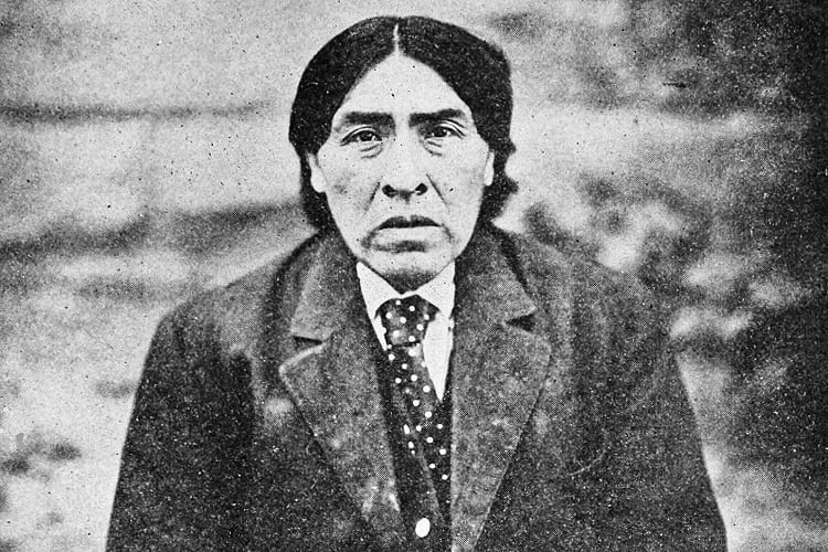
Ishi in 1915. (T.T. Waterman: The last wild tribe of California)
Imagine being hunted by people hellbent on killing you and your family, and, therefore, staying hidden for most of your life. And then, after all that, seeing your family and all your friends driven to their deaths, and finding yourself all alone in a hostile world. This, in a nutshell, is the story of Ishi, the Native American who is widely considered to be the last surviving member of the Yahi Tribe.
Ishi, the Native American of the Yahi Tribe
He was born sometime in 1860 or perhaps earlier. There is no exact record of his birth, but the first official record of him is from 1865. Settlers, who claimed that the Yahi were responsible for stealing cattle and killing some settlers at Lower Concow Creek near Oroville, described a young boy that was part of the group.
Shortly afterwards, 16 or 17 so-called Indian fighters attacked the Yahi camp and killed around 40 people in what became known as the Three Knolls Massacre. Some 33 Yahi managed to escape, but half of them were killed later and most of the others shortly thereafter. Ishi and his immediate family, which consisted of his mother, his sister, and his uncle managed to get away.
The background of the Yahi Tribe
The Yahi tribe was an offshoot of the Yana tribe, and, prior to the arrival of the white man, had lived for centuries on their traditional lands near the foothills of Mount Lassen. They were never numerous to begin with. There were around 400 Yahi people and 3000 Yana people before the California Gold Rush.
They moved around the thick forests, hunting deer, fishing for salmon, and foraging for wild vegetables. It wasn’t exactly an idyllic existence though. They had enmities with other native American tribes such as the Wintu, the Nomlaki, and the Maidu. These tribes portrayed them to the white settlers as ferocious and warlike people.
The destruction of the Yahi Tribe

James W. Marshall. (Wikimedia Commons)
In 1848, James W. Marshall first discovered gold in California and that set off the California Gold Rush. By 1849, the area was flooded with prospectors and people of different stripes, all determined to make a fortune. They were a hardened lot, caring only for money and profit. It would not have even occurred to them to have any concern for the native population. When most of the easily found gold had been mined by 1855, the avaricious crowd moved to the hills to look for more.
Their intensive gold mining activities poisoned the streams and depleted the salmon and frightened off the deer. The miners and settlers laid claim on the traditional Yahi lands and began threatening the inhabitants. Their aggression resulted in the California Indian Wars that lasted from 1850 to 1880. Armed with only primitive weapons, the Yahi warriors did not stand a chance against the gun-toting miners and settlers.
Considering the Yahi to be no better than vermin, the newcomers embarked on a killing mission. They hunted them down and slaughtered them.
In this way, the entire Yahi tribe was decimated. Ishi and his family, as mentioned earlier, somehow escaped and hid deep within the forest for the next 40 years.
The plight of Ishi and his Family
Towards the end of 1908, a group of surveyors stumbled upon the little, makeshift village in which Ishi’s family had been living. Ishi was not there then – although, one of the surveyors had seen him fishing the day before and had reported it to the group; they had refused to believe him – but the others, his uncle, sister, and mother were. The uncle and sister ran off to hide in the forest, after covering the mother with skins to hide her; since she was ill and bedridden, it wasn’t possible for her to flee.
The surveyors found her there, trembling with fear. They left her alone but stole everything they could lay their hands on. This included the food and tools that the Yahi needed for their survival. It was a callous act that effectively sentenced the survivors to death. One member of the group later claimed that he had tried to persuade the other to not take these things and to take the ill woman to a hospital, but they had ignored him.
Ishi returned after the surveyors departed and took his mother away, but the shock must have been too much for her—she had already seen white attackers murder her extended family before—and she died shortly afterwards. Ishi never found out what happened to his sister and his uncle. He tried to track them but was unsuccessful. It is probable that they too did not survive.
For the next three years, Ishi lived by himself in the forest in total isolation.
Ishi enters the modern world
On 29 August 1911, the butchers in a slaughterhouse in Oroville, a town near the foothills of Lassen Peak in Northern California, were aroused by the barking and snarling of the dogs outside. Going to check on the commotion, they found that the dogs had cornered a strange, emaciated, middle-aged man. He had burnt hair and was completely naked, except for a worn-out sheet of wagon canvas that was wrapped about his shoulders.
It was Ishi, who, after years of seclusion, had finally been forced by starvation to emerge from the wilderness to forage for food.
There was nothing threatening about him, but, taking him to be a madman, the butchers called the sheriff. The man thus ended up in the local jail. Unable to communicate with him, the sheriff summoned other Native Americans, but they couldn’t talk to him either.
The news of the ‘wild man’ spread around and reached Thomas Waterman, an anthropologist at the University of California, Berkeley. Intrigued, he took a train to Oroville and persuaded the sheriff to release the stranger into his custody. He then brought him back to San Francisco.
Ishi at the University of California
Ishi with anthropologist Alfred L. Kroeber. (Wikimedia Commons)
Thomas Waterman arranged for Ishi to live in an apartment at the University’s Museum of Anthropology. He and his fellow anthropologist, Alfred Kroeber, studied Ishi for the next five years. To enable Ishi to continue to remain at the University, they gave him a post as a janitor and taught him English.
The anthropologists learned much from him regarding the Yahi lifestyle, social relationships, ceremonies, traditions, implements, language, and more. Edward Sapir, a linguist who had studied the dialects of the northern tribes, recorded him for posterity. Regretfully though, as Ishi was growing up, most of the elders had either died or been killed, and so he only had limited knowledge of his own culture.
However, he knew enough to refuse to speak about certain things that were considered taboo in his culture. For instance, he couldn’t speak about the dead. Which was frustrating for the anthropologists as it prevented him from talking in detail about his tribal members and family.
He also could not tell the researchers his real name. In Yahi culture, your name was private information that you couldn’t divulge to strangers. Only another Yahi could tell another person your name. Since all the Yahi were now dead, there was no way for Ishi to tell anyone his name.
The researchers, therefore, called him Ishi for convenience. It means ‘man’ in the Yahi language.
During his five years at the University of California, Yahi contributed a lot to the general understanding of the Yahi culture. He also demonstrated his fire-making and implement-making skills to visitors. Furthermore—although, reluctantly—he took the researchers on a tour of his family’s traditional hunting grounds and showed them the places where they had camped as well as the places where they had died.
Ishi demonstrating his fire making skills. (Saxton T. Pope)
The death of Ishi
Ishi lived for only five more years after he walked down from the mountain into modern civilization. Having lived in isolation for most of his life, he did not have any immunity against the white man’s diseases. He was frequently ill while at the University, and was often in the care of Dr. Saxton T. Pope. He died of tuberculosis, which was then incurable on 25 March 1916.
Aftermath
Despite the fact that Yahi tradition forbade any tampering with the body and before Thomas Waterman could intervene—Alfred Kroeber was away in Europe at the time—the doctors at the University’s medical school carried out an autopsy. Ishi’s brain was removed for preservation and was later discovered to be in the collection of the Smithsonian Museum.
The brain and his ashes were returned to the Yana tribe at the Redding Rancheria – his closest kin – for a proper burial in 2000.
His life has been the subjects of many films and books, including the 1961 ‘Ishi in Two Worlds’ by Alfred Kroeber’s wife, Theodora Kroeber.
More current research suggests that Ishi probably was of mixed-blood origin and certainly not the last of the Yahi as has been widely claimed. Whether that is the case or not, it doesn’t detract from the series of tragedies that marked his entire life.
Enjoyed this article? Also, check out “North Sentinel Island: Home to an Uncontacted, Hostile and Primitive Tribe“.
Recommended Read:
Ishi in Two Worlds | By Theodora Kroeber
Fact Analysis:
STSTW Media strives to deliver accurate information through careful research. However, things can go wrong. If you find the above article inaccurate or biased, please let us know at [email protected].
RELATED
 January 28, 2019 Whipping Boy: When Young Slave Boys Took a Beating for the Mistakes their Masters Had Committed
 September 9, 2018 Human Greed for Power was Responsible for the Near Extinction of Bison during 19th Century
- July 13, 2018 Hanns Scharff: The Extraordinary Interrogation Technique of a Nazi Interrogator
 June 9, 2019 Ayahs’ Home In London: Where Abandoned Indian Nannies Were Sent to Live Out the Rest of Their Days
The post Life of Ishi: The Last Surviving Member of the Yahi Tribe appeared first on .
]]>The post Phantom Island: The Islands that Might Have Existed Only in the Imagination appeared first on .
]]>
An old map showing Bermeja, a phantom island near Mexico. (Tanner, Henry S.)
Phantom islands are islands that once appeared on nautical charts and maps but do not actually exist. There are various reasons for this. Some islands may have been purely mythical creations from old legends. Others may be deliberate fabrications, while others are geographical errors, optical illusions, or lands lost due to natural catastrophes.
Phantom Islands and the age of exploration
The Age of Exploration was a grand period in the history of mankind. The earth and its realms were a mystery to most people back then. There were many things they didn’t understand, and they tried to explain these with legends and fantasies.
As you can imagine, discovering new lands was a big deal in those times. It turned you into a hero overnight. And, if your home country’s reigning royalty didn’t try to steal your thunder, you could even name the new land after yourself. That could ensure your family was set for the next seven generations at least.
Despite such an incentive, comparatively few brave men actually set forth to traverse the vast oceans and make these new discoveries. The rest of the public remained safely at home and eagerly awaited their return and lapped up their tales of exciting adventures and marvellous sights. Naturally, some of these adventurers couldn’t resist playing to the galley and embroidering their trials and escapades to a good extent. In short, they added fuel to the existing legends.
It was easier to tell tall tales than to discover new lands. Often, to keep up and enhance their prestige, many of the voyagers outright lied about coming across an island or two. Travelling across the seemingly unending oceans for months on end was no child’s play. Sometimes you were glad to settle for an island, even if it was only a phantom island. Back then, nobody was going to take the next boat to go verify it after all. Or, if they did, there could always be a reasonable explanation for not finding it. Moreover, they could return with tales of phantom islands of their own.
Phantom Islands and nautical charts
In the Western world, the earliest Greek and Phoenician ocean farers began the practice of mapping the world. Piece by piece they tried to put together an entire picture of the earth. Other ocean farers that followed then made use of these charts to navigate the oceans. Furthermore, they added to them as they came across previously uncharted territories.
As a result of this practice, phantom islands also found their way on nautical charts.
However, all these phantom islands were not fabrications. Some were actual islands, but the voyagers got their geographical locations wrong. Or, they were actual islands that later disappeared into the ocean due to volcanic eruptions, underwater landslides, or some other natural disasters. In some cases, the voyagers mistook sandbars, icebergs, floating pumice from underwater volcanoes, and other debris for islands. In other cases, they didn’t survey the land correctly and mistook land that was actually connected to a larger landmass to be an island. Sometimes, the islands they thought they saw were only mirages or optical illusions.
Apart from the voyagers that reported these islands, nobody else was able to find or reach them again.
Despite this, many of these islands remained put on the nautical charts for many centuries. Even if other people couldn’t find them, they retained the hope they might someday be able to do so.
There are several hundred instances of phantom islands from the ages of antiquity to more modern times.
The last phantom island was Emerald Island, said to be near New Zealand. It even appeared in many atlases until 1987.
Famous Phantom Islands
Mythical Islands
The Greek poets Homer and Horace created poems on mythical islands like the Isles of Blest. Also known as the Fortunate Islands, these were supposedly Utopian islands where hardships were unknown. Of course, no human ship managed to sight, never mind land on, these fabled phantom islands.
Another famous island of legend was Atlantis. Plato mentions its existence and how it ultimately sank under the sea. The legend of Atlantis persists to the present day and many modern underwater explorers have had a go at finding it on the ocean floor. So far, nobody has been able to find anything that we can with a great degree of accuracy assume to have been Atlantis.
Actual Islands that were misidentified or were subject to geographical errors
In the 4th century BCE, Pytheas, an ancient Greek seafarer, arrived on an island he called Thule. Nobody else ever found it, but, since ancient times to the present age, explorers have argued that Thule was either Scandinavia, Iceland, or the Shetland Islands. Some say it didn’t even exist except in its discoverer’s salt-encrusted imagination.
For quite a long while, Pepys Island figured on the charts. Later, explorers discovered that it was not a different place. Just a different name for the Falkland Islands.
When early explorers to the American continent arrived in the Baja California Peninsula, they did not realize that it was connected to the mainland. Instead, they took it to be an island and noted it on the map as such.
Captain James Cook made a similar mistake when he landed on the Banks Peninsula in New Zealand. He mistook the 1150 square kilometres land mass to be a separate island, when, in fact, it is connected to New Zealand’s South Island on its eastern coast.
Islands that only their discoverers found
Ever heard of New South Greenland? It was also known as Morrell’s land after its discoverer, Benjamin Morrell. While captaining the Wasp schooner on a voyage of exploration in Antarctica’s Weddell Sea, he made his discovery in March 1823. According to the account he gave, his schooner sailed along 480 kilometres along the island’s coastline. He gave details of this and also marked the precise coordinates of the land. Nobody doubted his discovery and New South Greenland was duly added to the ever-expanding world nautical chart. However, in the 20th century, voyages to Antarctica proved conclusively that there was no such land. Captain Morrell, it turned out, was just another one in a long line of fabricators.
Islands that might have existed but no longer do
Spanish explorers of the 16th century came across Bermeja Island along the Yucatan peninsula’s north coast. In 1539, Alonso de Santa Cruz included the island in his El Yucatán e Islas Adyacentes. By 1844, however, British cartographers reported it had sunk underwater. There have been various theories about its disappearance. The best one involves the CIA—they sank it to extend the USA’s economic zone.
In 1825, George Norris, a captain of a whaling ship, came across Thompson Island in the South Atlantic Ocean. Another vessel reported sighting the island in 1893. Nobody ever saw it again thereafter. Researchers think it probably sank into the ocean after a volcanic eruption. However, until 1943, the world maps continued to include it.
Writer’s opinion
Phantom islands are a relic of a bygone era when one could cast an eye at the horizon and wonder about magical, mysterious lands that might exist way beyond. We now live in a somewhat more jaded age where some scientists actually think that there is nothing more for us to discover. They talk of ‘settled science’. Well, folks, nothing is that settled. As long as we are alive, there are discoveries to be made, even if only on the personal level.
Enjoyed this article? Also, check out “When Default Becomes De facto: Island of California, the Cartographic Mistake Which Became the Gospel Truth“.
Fact Analysis:
STSTW Media strives to deliver accurate information through careful research. However, things can go wrong. If you find the above article inaccurate or biased, please let us know at [email protected].
RELATED
 September 26, 2018 When Default Becomes De facto: Island of California, the Cartographic Mistake Which Became the Gospel Truth
 February 25, 2020 Leh Magnetic Hill: A Stretch of Road Where Laws of Gravity Work Peculiarly
- July 29, 2018 SS Baychimo: The Phantom Ship That Haunts the Arctic Waters
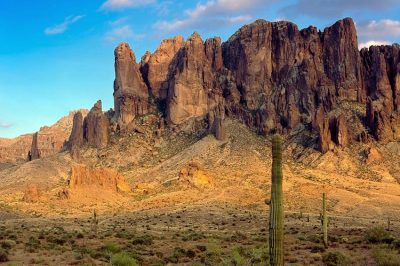 December 26, 2019 The Superstition Mountains and the Legend of the Lost Dutchman’s Gold Mine
The post Phantom Island: The Islands that Might Have Existed Only in the Imagination appeared first on .
]]>The post Bingham Canyon Mine: The Largest Copper Producing Mine in the United States appeared first on .
]]>
Bingham Canyon Mine. (Doc Searls / Flickr)
The Bingham Canyon Mine is an open-pit copper mine in the Oquirrh Mountains to the west of Salt Lake City in Utah in the United States. It is two and a half miles wide and a three-fourths mile deep. These dimensions make it the most extensive man-made excavation in the world. It is so large, in fact, that you can even see it from space.

Bingham Canyon mine from space. (NASA / ISS015-E-29867)
The Bingham Canyon mine
The mine gets its name from two Mormon brothers, Sanford and Thomas Bingham, who grazed their cattle there. Stumbling upon some copper ore in 1848, they were the first to realize the possibilities of mining in the area. However, the Mormon leader, Brigham Young, dissuaded them from carrying out the venture as it was more important for their people to establish a community right then. Bowing to that, they moved on to settle in Weber County. The canyon continued to be known as Bingham Canyon, though.
Mining in the Bingham Canyon mine
Mining operations began in 1863, and, since then, copper, gold, and silver have been the principal metals extracted from the mine. It also yields molybdenum and various other minerals. Around 25% of the total copper produced in the USA comes from the Bingham Canyon Mine. The mine has produced more than 19 million tonnes of copper over the years.
In the 19th century, a number of mining companies staked their claims in the mine. Their ore extractions, however, were mostly small-scale. It wasn’t until 1906 that open-pit mining for large-scale ore extraction commenced.
A township of miners and their families sprung up around the mine along the canyon walls in the 1920s, but it dwindled as the mining operations began using more sophisticated machinery and methods. Moreover, as the mine expanded, it began swallowing up more and more of the surrounding land, including sections of the township. The intensive mining operations resulted in a gigantic pit that is around 970 metres deep, 4 kilometres wide and extending across 7.7 square kilometres.

Inside the mine. (Hermann Luyken / Wikimedia Commons)
Mining Companies in the Bingham Canyon mine
Between 1906 to 1923, some of the mining companies merged and sold their shares to larger mining corporations. For instance, the Utah Copper Company sold 75% of its interest to the Kennecott Copper Corporation.
By the 1970s, the Kennecott Copper Corporation and the Anaconda Minerals Company had acquired all the other mining operations. Sohio took over the Kennecott Copper Corporation in 1981 and stopped open-pit mining operations in 1985. They began mining for gold in Barney’s Canyon the following year. BP Minerals bought the mine assets from Sohio in 1987 and mining operations resumed. The Rio Tinto Group has owned the mine since 1989 and has since spent billions of dollars in modernizing the mine and cleaning up the polluted groundwater.
The landslide at Bingham Canyon mine
After a massive and disastrous landslide on the mine’s northeast wall on 10 April 2013, the mine management closed it to visitors for several years. They worked on reducing the mine’s eastern slope in a bid to prevent any more landslides. The situation is now reasonably under control to allow visitors once again.
Visiting the Bingham Canyon mine
You can visit the mine from 1 April to 31 October—as long as the weather holds up—but it is necessary to make prior reservations and purchase tickets online. The mine donates all the income derived from visitors to various charities and non-profit organizations.
The mine is about an hour’s drive away from Salt Lake City, and you can only enter it via the company’s shuttle bus. The bus takes you on a 15-minute ride up to the top of the mine. As you go up and come back down on the bus, you can watch two videos about the mine and its operations. The videos detail the mine’s history and explain how the miners extract ore from the rock.
From the two observation decks at the top, you can get a fantastic view of the open pit mine and its many ridges. Moreover, you can listen to an audio presentation—available in multiple languages— detailing what is going on down below. There are winding roads looping up along the mine’s perimeter, and slow-moving trucks are the only visible traffic on them.
Situated at an elevation of 6700 feet, the most incredible thing about the mine is its sheer size.
You will probably come away more amazed at its immensity. From a height, the trucks that bear away the extracted ores look quite minuscule. From a close-up view, they are gigantic and capable of carrying 240 to 320 tons of ore. They deliver this to the crusher in the open pit. The machine then pounds it into small pieces. These crushed pieces are then loaded on a conveyor belt that extends for five miles towards the Copperton Concentrator.
Visitors can look at the displayed mining equipment, which includes a truck tire that stands 12.5 feet high and a shovel scoop and a haul truck bed, both so large that you can walk into them. You can also browse through the gift shop at the mountain base and purchase copper jewellery and other items.
In conclusion
The Bingham Canyon mine is an interesting example of how manmade activities can affect the environment. Aside from the gnawing out of an enormous pit in the earth, the mining activities have polluted the groundwater to such an extent that it is likely to remain unusable for a long time to come. On the plus side, the mining activities appear to have discouraged hunting in the area, and that led to a proliferation of wildlife.
Enjoyed this article? Also, check out “Potash Ponds: Where the Vibrant Blue Pools are Quite a Sight in the Red Desert“.
Fact Analysis:
STSTW Media strives to deliver accurate information through careful research. However, things can go wrong. If you find the above article inaccurate or biased, please let us know at [email protected].
RELATED
 February 1, 2019 Agbogbloshie: Africa’s Largest Ground for Dumping of Electronic Waste from World Over
 March 27, 2019 Monowi, Nebraska: A Village in Boyd County, United States with a Population of One
 January 6, 2019 Lake Crescent: Washington State’s Beautiful, Deadly Lake and its History of Chilling, Notable Incidents
 September 15, 2018 Potash Ponds: Where the Vibrant Blue Pools are Quite a Sight in the Red Desert
The post Bingham Canyon Mine: The Largest Copper Producing Mine in the United States appeared first on .
]]>The post Padmanabhaswamy Temple: The Richest Temple in the World with Gold Worth $22 Billion in Six Vaults appeared first on .
]]>
Padmanabhaswamy Temple in Kerala, India. (Pranav Yaddanapudi / Flickr)
Dedicated to Lord Vishnu — the Hindu God who is the Protector of the Universe — the Padmanabhaswamy temple is one of 108 main shrines where the Vaishnavities worship. It is also one of the richest temples in the world. The temple has an estimated wealth of over one lakh crore rupees ($22 billion). All the temple’s assets belong to Lord Padmanabhaswamy and a special trust, under the Travancore Royal Family’s chairmanship, manages these assets.
The Padmanabhaswamy Temple
In the temple, the deity is enshrined as Ananthashayi Vishnu. This literally means Vishnu lying in a supine position on the hooded serpent, Anantha Shesha Naga. And it is for this reason that the city in which the Padmanabhaswamy temple is located is called The Sacred Land of Anantha or Thiruvananthapuram. Also known as Trivandrum, the city is the capital of the Southern Indian state of Kerala.
The petition about the Padmanabhaswamy Temple’s wealth
In 2009, T. P. Sundararajan — a retired IPS of the 1964 cadre and, moreover, one who had been part of PM Indira Gandhi’s security staff — became concerned about the wealth of the temple after members of the Travancore Royal family claimed ownership of the temple. He was worried that the royal family would take all of the temple’s wealth into their own possession for their personal use.
As an ardent devotee of Padmanabhaswamy, T. P. Sundararajan took the matter to court. He filed a petition in the Kerala high court asking the state government to take over the management of the temple and its wealth. The royal family challenged this petition and the matter reached the Supreme Court.
In 2011, the Supreme Court stayed the petition to revoke control of the temple from the royal family. The Supreme court formed a seven-member team that included two former high court judges and a top state government official, authorities from the archaeology department and the fire services, and T. P. Sundararajan. The court directed the team to open the vaults where the wealth was stored and inventory it.
The vaults of Padmanabhaswamy Temple
Beneath the temple, there are six underground vaults and their antechambers. It is here that the temple’s management stores the temple’s hoard of gold. They have labelled the vaults A through F. Later, after the court appointed a team to check these vaults, they found that there were two more, previously unaccounted vaults. They labelled them as G and H.
The way to Vault A is through an opening in its granite floor. A granite floor slab must be moved first. There are stairs leading downward underneath. After going down these, the court appointed team found a chamber filled with gold coins, a variety of gold jewellery, and an assortment of precious gems. The treasures also included a diamond-studded gold throne, gold chairs, gem-encrusted gold crowns, gold chains, gold utensils, gold-threaded ceremonial attires, and more.
Nobody knows when Vault B was last opened, since the temple priests and the royal family refuse to say anything about it. The court appointed team encountered first a metal grille door and behind this, they came across a sturdy wooden door. Behind this wooden door, they found an iron door that was jammed shut. Before they could pry it open, the royal family got an injunction from the Supreme Court against opening vault B. Vaults G and H are also supposed to have remained closed for centuries.
Vaults C, D, E, and F are in the custody of two temple priests and they open the vaults at least eight times every year. They take out some of the gold for use on special ceremonial occasions such as temple festivals. Afterwards, they deposit it back into the vaults.
The priests and the Travancore Royal Family have not allowed a full inventory of the vaults so far.
The origins of the Padmanabhaswamy Temple treasures
Most of the temple’s treasures are believed to have been accumulated over a thousand or more years. Ever since the temple was built sometime before the 8th century, devotees have been donating gold and other valuables to the temple. Also, the Kings of the Chera, Pandya, Kolathiri, Pallava, Chola, and many other dynasties made generous gold offerings to the deity.
Furthermore, the Malabar region, known as Tamilakam in previous centuries, once had several major centres of trade and commerce, from Vizhinjam in the South to Mangaluru in the North. Traders from Mesopotamia, Rome, Greece, and other foreign locations regularly came and went. And they also made donations to the Padmanabhaswamy Temple.
Some of the temple’s treasures came from taxes collected by the Travancore Kings as well as from the bounty collected when they conquered other Kingdoms.
When Tipu Sultan invaded neighbouring Kingdoms, the royal families of those Kingdoms took refuge in Thiruvananthapuram. They also placed their wealth for safekeeping in the Padmanabhaswamy temple.
Between 1810 and 1813, Maharani Gowri Lakshmi Bai brought hundreds of temples that were mismanaged under the government control. Some of the wealth in these temples was transferred to the vaults of the Padmanabhaswamy temple.
The ownership of the treasures in the Padmanabhaswamy Temple
According to various Indian Acts and Laws, only the Central government has the right to manage any treasure of heritage value. This does not mean that the government can sell the treasure to make money. It has a constitutional obligation to preserve the treasure.
There are various suggestions floating about on what is to be done with the treasures in the Padmanabhaswamy temple. A scholar suggested that they should be placed in a museum near the temple for the public to view and historians to study. A former Supreme Court justice wants the treasure to be sold to raise money for social activities. Some conservation experts want to move the treasure from Kerala’s tropical climate and high humidity to a protected environment.
Hindu organizations say that the treasure belongs to the temple and should not be moved from its precincts.
Since there are documents that prove that most of the treasures were donated to the temple, neither the government nor the Royal family can lay claim to it. Everything belongs to the temple and to Lord Ananthashayi Vishnu.
Enjoyed this article? Also, check out “Batu Caves of Malayasia – The Largest Shrine to Lord Murugan Outside India“.
Fact Analysis:
STSTW Media strives to deliver accurate information through careful research. However, things can go wrong. If you find the above article inaccurate or biased, please let us know at [email protected].
RELATED
- September 21, 2019 Batu Caves of Malayasia – The Largest Shrine to Lord Murugan Outside India
- May 12, 2019 Cambodia’s Magnificent Angkor Wat: One of the Largest Religious Monuments in the World
- July 17, 2019 The Lonar Lake: An Astronomical Marvel
- April 22, 2019 Incredible Ta Prohm: The Ancient Khmer Temple in Cambodia
The post Padmanabhaswamy Temple: The Richest Temple in the World with Gold Worth $22 Billion in Six Vaults appeared first on .
]]>The post Raëlism: The UFO Religion That Believes in Extra-Terrestrial Beings Called Elohim appeared first on .
]]>
The symbol of Raëlism. (Sarang / Wikimedia Commons)
All religions are not formed equal. Some have earthly origins, while others, like Raëlism, come to us from extra-terrestrial sources. The followers of Raëlism believe that all the living beings on earth are the creations of a highly intelligent and advanced race of aliens known as Elohim. They zoom around the earth in their UFOs and keep a watch over us. If we can overcome our baser natures, we may become eligible to become part of the great Elohim civilization on their far away planet.
The UFO religion of Raëlism
Raëlism is not a monotheistic religion. Its followers believe in different Elohim, but since they don’t believe in God, they often call themselves an atheist religion. There is a seven-level clerical hierarchy, and followers must officially renounce their beliefs in all other religions. They must believe, instead, in world peace, non-violence, democracy, and sexual permissiveness.
The founder of Raëlism
Claude Vorilhon, a Frenchman who was born in 1946, is the founder of Raëlism. Before he became a self-made prophet, he worked as a journalist and was also a race-car driver.
When he was 27 years old, on 13 December 1973, he had his first alleged “alien encounter” in the Puy de Lassolas volcano park in France. According to him, he was beamed up to a spaceship belonging to the Elohim. They informed him that he was half-Elohim and gave him the details of the entire history of humankind on earth. They also told him that they had selected him to bring enlightenment to the human race. After that first meeting, he met with them in the park six more times and decided to give up his dual careers and become their full-time representative on earth.
He began calling himself by his Elohim name, Raël, travelled around the world to promote his new religion, and wrote several books about his experiences with the aliens—”The Book Which Tells the Truth”, “Extraterrestrials Took Me to their Planet”, “Intelligent Design”, “Sensual Meditation”, “Geniocracy”, and “Yes To Human Cloning”. He has also appeared on many TV shows, addressed the American Congress, and hobnobbed with international politicians and celebrities.
Raël has been married three times, including to a 16-year old girl.
The beginnings of Raëlism
On 19 September 1974, Claude Vorilhon addressed an audience of 2000 people at a conference in Paris in France. He made a sufficient enough impression to gain 170 adherents for his new faith and went on to form an organization called “Mouvement pour l‘accueil des Elohim, créateurs de l’humanité” (Movement for the Welcoming of the Elohim, Creators of Humanity) or MADECH. Later, in 1976, this became the International Raëlian Movement.
The key tenets of Raëlism
According to Raëlism, there are human-like aliens known as Elohim that came to earth in UFOs from a distant galaxy. They are scientifically and technologically advanced beings, and they created the human race as clones of themselves. We are, in fact, a scientific experiment that they are conducting on earth.
The Elohim have been trying to uplift humanity for centuries. To achieve this goal, they sent enlightened prophets in our midst. All those prophets that started all those other religions—Buddha, Mahavir, Jesus, and so on—they were all sent by the Elohim for our benefit. Apparently, when the Elohim made us, they were not able to create totally non-defective specimens.
The prophets chosen by the Elohim, including Claude Vorilhon, are half-Elohim, the result of the mating of the Elohim with human women.
Raëlism believes in liberal sexual mores and free love for everybody. They call it sex positivity.
Controversies of Raëlism
Sexual parties
Given the free love beliefs of Raëlism, its followers participate in orgies and engage in liberating and non-traditional and non-monogamous sexual acts. According to Raëlism, engaging in free love helps to replenish the brain cells and, thus, expands the human intellect. It is a form of meditation that allows the adherents to communicate with the Elohim. To promote this erotic meditation, Claude Vorilhon has made a point of distributing condoms to school students and encouraging them to engage in masturbation.
White and pink angels
The White Angels and the Pink Angels are young women selected for their extraordinary beauty. The Pink Angels are the elite of the elite. These young ladies take a vow of earthly celibacy that they will hold on to until the Elohim arrive to offer salvation to all of us. So, they don’t engage in physical relationships with anyone, except the founder Claude Vorilhon; he is half-Raël, so that is quite alright. The Pink Angels made a splash in larger human society when they posed with Claude Vorilhon for the porn magazine, Playboy, in October 2004.
Go topless day
The followers of Raëlism believe that the human body is nothing to be ashamed about and that there should be equality between men and women. That means, if men can go topless in public without any qualm, women should be able to do so too. To protest a state law that banned women from exposing their areolae and nipples in public and to create a safe public environment for women wishing to expose their breasts, they announced the Go Topless Day. They arranged a public parade of half-naked women outside the Arizona State University. They also paraded through New York City in 2014. While their cause has garnered some support from the ‘Free the Nipple’ crowd, the larger public doesn’t seem to be falling in line.
Clitoraid
Raëlism is also concerned about other social justice issues in other countries. They have set up an independent organization called Clitoraid in 2006. It is active in Burkina Faso and many other African countries to help victims of female genital mutilation. The doctors and surgeons that work with Clitoraid in these countries use reconstructive surgery to rebuild the clitoris. While this is certainly humanitarian work, the locals in many of the countries have accused the organization of promoting degenerate Western sexual mores alongside.
Human cloning
According to Raëlism, the human gene pool needs purification, and this can happen only through human cloning. The adherents of Raëlism are keeping their fingers crossed that cloning techniques will soon become so advanced that actual human childbearing will become a thing of the past.
In September 2000, the Raëlism organization announced a new upcoming company called Clonaid to work on human cloning. At the press conference, the Angels said they would be willing to act as surrogates for their religion’s cloning venture. In 2003, Clonaid made the startling announcement that they had been successful in cloning the world’s first human clone. However, after causing a stir, the company did not bring forth the proof.
Religious suppression
While advocating sexual liberation, world peace, and democracy, Raëlism is remarkably close-minded about tolerating other religions. The organization demands their followers must renounce all other beliefs. Furthermore, they also want all other religious texts to be censured for failing to live up to their definition of human rights.
The future of Raëlism
There are, reportedly, around 100, 000 adherents of Raëlism in 97 countries around the world, including the United States, Canada, South Korea, and Australia. The United States boasts the largest number of Raëlism followers. Given the adaptability of the religion and the credulity of human beings, it is likely it will continue to find followers and grow.
The Raëlism organization is hoping to build an official embassy in readiness for the arrival of the Elohim and would like some of the leading countries to volunteer land for the purpose.
In conclusion
Many of us associate religions with centuries-old philosophies and ancient prophets or godmen. However, as Raëlism shows, religions can be pretty modern. You too can be the founder of one, if you put your mind to it. The first requisite is coming up with an original philosophy—or having the skill to mix up several existing philosophies to come up with something that sounds new. The second requisite is getting other people to believe in it. If you can get past that barrier and gather followers, you are all set to become a revered prophet. Just like Claude Vorilhon.
Human beings are pliable beings that—with sufficient marketing as well as social and legal coercion— can be made to believe absolutely anything.
Raëlism might have seemed radical in the 1970s, but it comes across as quite tame in comparison to some of the “social justice” issues of the present century. Perhaps those explain why the Elohim haven’t landed yet.
Enjoyed this article? Also, check out “Zoroastrianism: The Oldest Monotheistic Faith is Now on the Verge of Extinction“.
Fact Analysis:
STSTW Media strives to deliver accurate information through careful research. However, things can go wrong. If you find the above article inaccurate or biased, please let us know at [email protected].
RELATED
 May 7, 2020 The US Department of Defense Has Released a Footage of UFOs but What Is It Actually?
 January 7, 2019 Was Canada’s VZ-9 Avrocar Flying Saucer the UFOs That Were Seen on Earth?
 November 27, 2018 Area 51: Is America Really Building UFO’s?
 June 20, 2019 Zoroastrianism: The Oldest Monotheistic Faith is Now on the Verge of Extinction
The post Raëlism: The UFO Religion That Believes in Extra-Terrestrial Beings Called Elohim appeared first on .
]]>The post Sewers of Paris: The Massive Underground Sewers That Keep Paris Clean appeared first on .
]]>
Sewers of Paris. (Shadowgate / Flickr)
Modern cities have very complex mechanisms in order to function properly and provide their inhabitants with reasonably decent and hygienic living arrangements. The massive underground sewers of Paris play an important role in maintaining civic hygiene. Without them, the city might descend into a cesspit of dirt and disease.
The sewers of Paris
The sewers of Paris are an underground system of drains and waterways that remove waste generated in the city and also bring in supplies of freshwater into the city. These underground sewers exactly replicate the streets overhead. All buildings in the city are connected to the sewers. The waste and wastewater are carried off to treatment plants; they are not directly released into the Seine river.
Paris’s underground sewer system is the biggest in the world. If you stretched out the pipelines, they would cover over 2,100 km. Daily, more than 1.2 million cubic meters of wastewater passes through these sewers.

Musée des Égouts de Paris. (Shadowgate / Flickr)
Why were the Sewers of Paris built?
The sewers of Paris were built to conduct away wastewater and to funnel clean water. The end goal was to make Paris a more liveable city for its citizens. Believe it or not, for quite a long while this wasn’t the case.
On the site where Paris is currently situated, there was once a Roman city name Lutece. If you’ve read the Asterix and Obelix comics, it is frequently mentioned in those stories as Lutetia. Anyhow, the Romans were first-class engineers and knew the importance of drains and sewers for getting rid of waste and wastewater. It was probably bearable to live in Lutece in their time.
Things changed, however, in the Middle Ages. They are also often called the Dark Ages and for good reason. People took to neglecting personal cleanliness and so there was no question of maintaining any civic hygiene. Everyone threw animal and human waste and wastewater into the unpaved streets or directed it into the fields. The situation was further exacerbated by the draining of all the waste ultimately into the Seine river. So, the streets stank, and the river stank, and the people tolerated living in these stinky environs as a fact of life.
They covered their noses and came up with new fashion ideas to combat pollution. Women took to carrying parasols to ward of garbage thrown from overhead windows. Men, meanwhile, adopted the chivalrous habit of walking closer to the street so that they would get landed with the sewage rather than their ladies.
As the population grew, the Parisian authorities tried to combat the waste problem with cesspits and cesspools. An effort was made to collect all the city waste to deposit them in these. However, many people either couldn’t or wouldn’t pay for this service. It was so much easier to empty the chamber pot out the window. Also, neither the cesspits nor the cesspools worked too well. The cesspits turned the soil fetid and the cesspools were difficult and messy to clean routinely.
This general lack of sanitation and cleanliness was common in most medieval European cities, not just Paris. It was one of the main reasons for the frequent epidemic outbreaks that killed thousands upon thousands of people.
Who built the Sewers of Paris?
Phillipe Auguste ruled France from 1180 to 1223. Sickened by the dirty, muddy streets of Paris, he ordered the civic authorities to pave them. While doing so, he also ordered for a drain in the centre of the streets to take away the wastewater. These were the first official drains in Paris. While they were useful to an extent, their open nature made a stink and the spread of disease unavoidable.
As the civic authorities came to realize this, they began to consider the idea of covered drains and then underground sewers to remove the waste and dirty water from the city precincts.
A Parisian provost named Hugues Aubriot built a stone-made sewer with a vault for wastewater in the Rue Montmartre in 1370. This was the first closed drain in Paris. Known as the Menilmontant sewer, it took wastewater from the Seine’s right bank to the Menilmontant brook.
After the first underground sewer was built in 1370, the French government has continually added, expanded, repaired, and modernized the sewers. You could say that they have remained a work in progress over hundreds of years.
Under King Louis XIV and, later, Napoleon Bonaparte, the Parisian authorities built an extensive system of underground sewers. These were bigger to accommodate the waste generated by the city’s growing population. However, the waste still went into the Seine and, as a result, continued to cause diseases like typhoid and cholera.
It became clear that the city needed a better system of sewers. Napoleon I ordered the construction of a 30 km long sewer network. It was vaulted and was the first Parisian sewer built in this manner.
In 1850, Napoleon III and Baron Haussmann, the Prefect for the Seine, began transforming Paris with new, broad boulevards. At this time, they hired Eugene Belgrand, an engineer, to design and oversee the building of new sewers. By 1878, Eugene Belgrand had built a 600 km long new sewer system with one network for drinking water, one network for water for street cleaning, one network for sanitary sewers, and one network for wastewater.
These large-sized, six-feet high drains were made of sandstone and had roads that sewer worker could easily walk on to facilitate sewer-cleaning. Sewer workers used boats to move the sludge in the sewers to barges that then took and deposited it elsewhere. Sometimes the sludge was also removed via manholes.
Belgrand also built a treatment plant to treat the waste. Furthermore, he built aqueducts that brought clean drinking water to the Parisian populace. From 1880 to 1914, more than half of the Parisian buildings were connected to the sewers.
There was a dramatic drop in typhoid and cholera cases in Paris as a result of Belgrand’s new sewer system. The French authorities continued to build this sewer system until 1930. At this point, nearly every Parisian street had a sewer under it. Now, the waste from the sewers was taken to the newly built Acheres treatment plant for industrial sewage treatment.
At one point, gas mains were also installed in the sewers. However, after gas leaks caused explosions inside the sewers, the authorities removed the gas mains.
Modernization of the Sewers of Paris
By 1977, there were 1000 km of new sewers. The Acheres treatment plant became one of the largest of its kind in Europe. The authorities also built other waste treatment plants like Noisy-le-Grand, Valenton, and Colombes.

Sewers under the Boulevard at the end of the 19th century. (Collection personnelle Scanné par Claude Shoshany)
In the 1990s, the then-Mayor of Paris, Jacques Chirac, undertook the modernization of the sewers. The project cost over 152 million euros. The French authorities repaired many of the existing sewers, built some new ones, and installed a computerised waste management system.
The sewers of Paris in literature
One of the most notable mentions of the Parisian sewers occurs in Victor Hugo’s famous novel from 1862 ‘Les Miserables’. Here, the sewers are part of the story and serve as a hideout as well as a getaway place for the main character. Victor Hugo’s portrayal of the sewers is pretty accurate as he got most of his factual information from Emmanuel Bruneseau, a sewer inspector who mapped the sewers.
The sewers also feature in ‘The Underground City,’ the 1958 novel by H. L. Humes, in ‘The Phantom of the Opera’, in ‘Foucault’s Pendulum’ by Umberto Ecco, and in ‘Ratatouille’.
Visiting the sewers of Paris
If you would like to see the sewers of Paris, you can take a guided or self-guided tour of them.
The sewers have been open for public visits since the World Expo held in Paris in 1867. There is now a Paris Sewers Museum from which you can take a stairway down to the sewers. Except for Thursday and Friday, it is open throughout the week from 11 a.m. to 5 p.m.

Paris sewers museum. (Shadowgate / Flickr)
Formerly, tourists could see how the sewers worked by taking a tour via suspended carts, locomotive-drawn carriages, and underground boats. Now you can walk through them and look at historic photographs and old machinery that was once used to clean the sewers. The latter includes large metal balls that water pressure pushed through the sewers to removed clogged debris.
The tour takes about 30 minutes and is, largely, stink-free.
Note: Currently, the sewers museum is closed for renovation until 2020.
Fact Analysis:
STSTW Media strives to deliver accurate information through careful research. However, things can go wrong. If you find the above article inaccurate or biased, please let us know at [email protected].
RELATED
 August 18, 2019 The Trans-Alaska Pipeline System – An Engineering Marvel of the 20th Century
 August 14, 2019 Puente Nuevo: The Bridge That Spans Across a Gaping Canyon to Join the City of Ronda
- November 29, 2019 Pan-American Highway: The Longest Road in the World Measuring About 30,000 Kilometres
 October 8, 2018 Great Stink of 1858: When London Crumbled Under an Obsolete Sewage System
The post Sewers of Paris: The Massive Underground Sewers That Keep Paris Clean appeared first on .
]]>The post MS The World: Life on Board the World’s Largest Residential Cruise Ship appeared first on .
]]>
MS The World. (Bob Adams / Flickr)
The World is a privately-owned, 644-foot, luxurious, residential ship. It is a floating home with a private veranda from where residents can view constantly changing scenery.
About MS The World
Knut Utstein Kloster first came up with the idea of a residential ship. He is a Norwegian shipping magnate whose family successfully runs various cruise ships. The Swedish company Öresundsvarvet built the ship’s hull in Landskrona, and Mekaniske Verksted of Rissa, Norway, made the other parts. The ship officially launched in March 2002 in Oslo.
Residensea, a business based in Miramar, Florida, USA, operates MS The World, and they have registered the ship in the Bahamas. The ship’s home port is Port Everglades in Fort Lauderdale, Florida.
Alongside Residensea, the ship’s residents are involved in its management. They have an elected board of directors and a number of committees. These decide what types of activities will be available to the residents, the sea and ocean routes the ship is going to follow, in which countries and ports the ship is going to dock and for how long, and how to manage the ship’s finances.
Their responsibilities also include managing over 250 staff members that are necessary for operating and maintaining the ship, providing services such as housekeeping, and managing the other facilities on the ship.

The World cruise liner in Spain. (Rab Lawrence / Flickr)
Residences on MS The World
Residents of the ship enjoy a rich and exclusive lifestyle. There are only 165 individual residences on the ship. These are categorized into four types, ranging in size from 1,350 square feet to 3,200 square feet. Designed in different configurations, the residences and other facilities are spread across 12 decks and are accessed by six elevators.
There are studio residences with one or two bedrooms and a lounge-kitchenette and two-bedroom residences with kitchen and spacious dining area. Also, there are three-bedroom residences with a foyer and gourmet kitchen.
All these residences have stylish and comfortable modern décor that includes en suite bathrooms, spacious living rooms, and verandas. Furthermore, the residences also have all modern amenities like internet and high-quality audio and video systems.
People from over 40 countries own residences on the ship. Some of them live onboard all year round, while some come aboard only for specific durations. Some residents often rent out their residences. At any time, at least 200 people are resident on the ship.
Food and drinks on MS The World
If residents don’t feel like dining in one of the six restaurants on board or cooking a meal themselves, a master chef will prepare one especially for them in the resident’s kitchen. All the chefs on The World can cook a variety of international cuisines with the best ingredients.
When the ship is in port, the kitchen staff visits the local markets to buy fresh and indigenous ingredients. Any of the residents, who are interested in food, can accompany the staff to the local markets to expand their culinary knowledge and to get acquainted with the local food culture. The staff also arranges local dining experiences.
The Beverage Team creates unique cocktails with local fruits and spices, so the cocktail menu changes at practically every port. Residents can drink cocktails in several lounges and bars on board.
The ship also offers an extensive wine list for residents to choose from. The management often invites winemakers on board to discuss the wine production with the ship’s residents and arranges for visits to vineyards for wine-tasting and fine dining. When buying new wines, the staff always considers the wines that the residents prefer.
Onboard activities on MS The World
Since there are plenty of things to do on board, there is little likelihood of the residents getting bored. There are many activity areas and rooms as well as shops on two decks of the ship.
There is a well-stocked grocery store and a boutique for clothes. In addition, residents can get beauty treatments at the health spa and sauna, meditate in the relaxation room, and pray in the religion room Harmony.
There is also a full-size tennis court, a billiard room, a gym, a yoga room, a jogging track, and indoor and outdoor swimming pools. Moreover, there is a golf centre with hi-tech simulators. For those interested in golfing or diving, the ship’s staff can recommend the best courses and dive spots at the places the ship is going to dock.
Residents can watch films in the full-size theatre Colosseo, read books in the library, gamble in the casino, and dance in the nightclub. There is even a theatre for live music performances.
The business room has the usual telecommunication facilities for residents to conduct business meetings. A licensed stockbroker is also available to facilitate stock market transactions.
The ship has a helicopter landing pad for residents who wish to hire a helicopter to transport them when the ship is docked or near land.
In some ports, residents can launch sailboats and kayaks from the ship’s retractable marina deck.
Besides all these activities, residents can take classes to learn languages, dancing, cooking, music, photography, and lots more.
Expeditions from MS The World
The staff arranges expeditions to locations that are likely to provide the residents with new cultural experiences. Residents can get to know diverse biological environments, observe exotic flora and fauna, and learn about local history. Industry experts in these areas help organize these expeditions and give talks on related topics. With this available knowledge, residents find it more fascinating to explore new areas, participate in local festivals, and observe wildlife. Many of the residents maintain blogs about the expeditions as well as life onboard.
Some of The World’s noteworthy expeditions include the Northwest Passage and the Bay of Whales. In 2012, the ship followed the route of Roald Amundsen who, in 1906, was the first sailor to go through what is now called the Northwest Passage from Nome, Alaska, to Nuuk, Greenland. The World is also the first cruise ship to navigate south into the Bay of Whales in the Ross Sea, Antarctica.
For the exclusive group of very rich people who live on the ship, The World is indeed the world where life and business go hand in hand in restful luxury.
Enjoyed this article? Also, check out “Seawise Giant: The Enormous Vessel That Remains the Biggest Man-Made Ship Ever Built“.
Official Website:
The World: Residences at Sea
Fact Analysis:
STSTW Media strives to deliver accurate information through careful research. However, things can go wrong. If you find the above article inaccurate or biased, please let us know at [email protected].
RELATED
 December 9, 2018 CSCL Globe: The Largest Container Vessel in the World, Until MSC Oscar Usurped its Ranking
 July 6, 2018 Seawise Giant: The Enormous Vessel That Remains the Biggest Man-Made Ship Ever Built
 April 6, 2020 USNS Comfort: A Ship of Hope Amidst Corona Crisis
 September 19, 2019 Sea Shadow (IX-529): The Story of Surreal Stealth Ships Which Defy the Enemy’s Stranglehold and Strike
The post MS The World: Life on Board the World’s Largest Residential Cruise Ship appeared first on .
]]>The post Leonardo’s Robot: Leonardo da Vinci’s Mechanical Knight and Other Robots appeared first on .
]]>
A recreation of Leonardo’s robot or mechanical knight based on his drawings. (Erik Möller / Wikimedia Commons)
Leonardo da Vinci, one of the greatest geniuses of the Italian Renaissance, designed and constructed a mechanical knight way back in 1495. According to historical sources, this mechanical knight was capable of humanistic movements.
Leonardo da Vinci — Genius of the Italian Renaissance
The Italian Renaissance was one of the greatest epochs in human history. During this period, there were extraordinary developments in art, sculpture, architecture, philosophy, literature, and many other human endeavours.
A rediscovery of Ancient Greek and Roman cultures—from surviving works that Islamic scholars had preserved as well as surviving art and sculptures— influenced and inspired most of the artists, sculptors, architects, writers, philosophers, and other intellectuals. Using the Greek and Roman works as their base, they built further on these to create astonishing masterpieces.
As you might expect, there was no dearth in geniuses engaged in these activities, but Leonardo da Vinci is a personality that still manages to tower over everyone.
In terms of output, he was not actually as prolific as some of his contemporaries. A restless spirit, he had a mind that overflowed with so many ideas that he didn’t have the time to bring them all into fruition. He painted only a few paintings, most of which are now very well-known, like the Monalisa, the Last Supper, and The Virgin and Child with Saint Anne. His fame rests on these as well as on the fact that he was a very multi-faceted man.
Apart from art, he could turn his hand at architecture, mechanics, armaments, and more. His many surviving notebooks are filled with designs and ideas. Some of which were advanced not only for his time but come across as amazing in ours as well.
Leonardo da Vinci’s mechanical knight
In 1957, the researcher Carlo Pedretti discovered some of Leonardo da Vinci’s sketchbooks that contained design notes for a mechanical knight. While there isn’t one single complete drawing of the mechanical knight—if Leonardo da Vinci made a complete drawing, it didn’t survive over the ages—there are many fragmented details of the design in various sketchbooks.
Historical accounts had already mentioned da Vinci’s famous Automa cavaliere that is Automaton knight. However, most people assumed these stories were exaggerated. The discovery of the notebooks proved this was not so.
Leonardo da Vinci designed the mechanical knight to impress his patron Ludovico Sforza, who was the ruler of Milan. In 1495, Ludovico Sforza had a pageant at his court and asked Leonardo da Vinci to oversee all the arrangements of the celebration. The latter, of course, outdid himself when he unveiled his mechanical knight at this gathering. Apparently, it left everyone there thunderstruck. They had never imagined seeing a machine that resembled an anatomically correct knight and, moreover, moved like one too.
Design of Leonardo’s robot
It is well-known that Leonardo da Vinci carried out extensive anatomical research. He even dissected cadavers and made detailed drawings of their interiors. As a result, he developed a deep understanding of the human body. He was able to figure out that it was the muscles that enabled the bones and joints to move.
When he designed his mechanical knight, he made sure it was anatomically correct. The knight has proportionate limbs and joints that follow the Canon of Proportions that Leonardo noted in the Vitruvian Man. Furthermore, he tried to incorporate the way human muscles worked into the design.
Clad in medieval German-Italian armour, Leonardo’s robot could move its arms and raise its own visor and wave its sword. It could also move its jaw and neck. Furthermore, it could sit, stand, lie down, and walk. These robotic movements were very advanced and human-like for that period. In fact, we can say that the mechanical knight was the first humanoid robot that the world ever knew.
How Leonardo’s robot worked
Known as Robot di Leonardo or Automa cavaliere, that is Automaton knight, the machine used two elaborate and connected systems made up of pulleys, cables, gears, and wheels to move. In his article ‘The da Vinci Robot’, Michael Moran tells us that one of these systems was a four-factor one and was used for the movements in the hands, wrists, elbows, and shoulders. Leonardo fitted this cylindrical system into the knight’s chest. The other system was external and tri-factor, and it was used to move the ankles, knees, and hips. All the movements were to the drumbeat.
Modern reconstructions of Leonardo’s robot
In 1996, Mark Rosheim, a modern-day researcher and robotics expert, studied Leonardo’s different design notes for the mechanical knight. Later, in 2002, he used them as blueprints to replicate the mechanical knight. Amazingly, he found that it worked exactly like the historical accounts had said it did.
In addition to creating a model of Leonardo’s robot, Mark Rosheim also used some of his design ideas to build robots for planetary exploration for NASA.
You can find how Rosheim built the mechanical knight as well as other of Leonardo’s robots—a programmable cart, a bell-ringing automaton, and a lion—in his book “Leonardo’s Lost Robots.”
There is also a research group of Leonardo da Vinci aficionados called Leonardo3. They have also engaged in discovering, interpreting, and reconstructing Leonardo da Vinci’s inventions.
Their book “Leonardo da Vinci’s Robots” contains reproductions of Leonardo’s original designs and manuscripts. Further, along with this book, Leonardo3 offers a kit with which you can have a go at building Leonardo da Vinci’s programmable cart yourself.
Other robots designed by Leonardo da Vinci
As mentioned above, Leonardo da Vinci used his engineering skills to design other robots as well. These include a mechanical lion that, like the knight, was capable of movement. It could walk and, supposedly, could also hold and offer flowers. While there are no eye-witness accounts of this lion, Leonardo apparently designed it for Guiliano de Medici to be given as a gift to the King of France. In 2009, the French museum, the Château du Clos Lucé and Parc, built a modern version of this lion.
Leonardo da Vinci was an incredible man for any age. His ideas and designs of robots have considerably aided the development of modern robotics. It is interesting to wonder about the things he might have achieved if he had access to many of our modern conveniences.
Enjoyed this article? Also, check out “The Turk: The 18th Century Automaton Chess Player was a Fore-Runner of Computer Age“.
Fact Analysis:
STSTW Media strives to deliver accurate information through careful research. However, things can go wrong. If you find the above article inaccurate or biased, please let us know at [email protected].
 Recommended Read:
Leonardo’s Lost Robots | By Mark Rosheim
Genre:
Non-fiction > Science
RELATED
 November 4, 2018 The Turk: 18th Century Automaton Chess Player was a Forerunner of Computer Age
- July 27, 2019 Wind in the Willows: The Singing Ringing Tree
 January 9, 2019 Peacock Clock: An 18th Century Automaton Marvel
 February 22, 2019 The Summoning of Demons: The Dangers of Artificial Intelligence
The post Leonardo’s Robot: Leonardo da Vinci’s Mechanical Knight and Other Robots appeared first on .
]]>The post Neptune Memorial Reef: An Eco-Friendly Underwater Graveyard Off the Florida Coast appeared first on .
]]>
Neptune Memorial Reef. (Todd Murray / Flickr)
The Neptune Memorial Reef is both the largest artificial reef in the world and an underwater columbarium. It is a member of the Green Burial Council and provides an alternative to burials on land. Located at a distance of five kilometres from the coast of Key Biscayne in Florida, it is spread over 65,000 square meters and lies under 40 feet of water.
The reef’s inauguration took place in 2007 after it got clearances from various government bodies. As per these clearances, its construction can withstand most natural disasters, and it is not likely to pollute the marine environment of the Florida coast.
A coral reef
A reef is a natural underwater structure formed of sand, rocks, corals, sponges, and other marine materials. It occurs in relatively shallow waters near a landmass. The most common reefs are the handiworks of corals. These marine invertebrate animals live in colonies and secrete calcium carbonate to form exoskeletons. Over the years, as the corals propagate, their hard skeletons create the framework of the reef.
Coral reefs create a protective barrier for coasts, and they also provide food as well as shelter structures for some marine life. By living in the coral reefs, these creatures are better able to protect themselves from predators and bad weather. Furthermore, coral reefs are safe areas for spawning.
The Neptune Memorial Reef
Gary Levine, a diver, came up with the idea of creating an artificial reef to promote marine life and also to serve as a recreational area for divers. He joined the Neptune Society, one of the largest cremation companies in the US, to develop an underwater cremation memorial site.
Usually, people store cremated ashes in urns or spread them over a waterbody or under trees. An underwater cremation site was an unusual proposition. However, it did attract a segment of the population that had a fascination for the ocean and all things marine. They liked the idea of getting themselves memorialized by placing their ashes in a marine environment. Moreover, contributing to the formation of a coral reef in this manner was something they found appealing.

Inside the memorial reef. (Todd Murray / Flickr)
Their families also liked the idea of an eco-friendly memorial site, where, aside from remembering their loved ones, they would be able to observe the fish and other marine creatures on the reef. Some of the family members acquired scuba diving certifications solely for this purpose. Family members, who are unable to dive, can snorkel, swim, or boat over the memorial site to scatter flowers.
Design of the Neptune Memorial Reef
The artist Kim Brandell was given a free hand to conceptualize the Neptune memorial reef. He designed its first phase to look like a sunken city, akin to the Lost City of Atlantis but with a lot of modern design elements. Plans for other phases of the memorial reef, yet to be built, include dance and music themes, with sculptures of dancing figures and musical instruments.
Lion sculpture at the artificial reef. (Todd Murray / Flickr)
The sunken city has two entrance gates made of brass and flanked by bronze lions. From these gates, several paths lead to a central plaza and then diverge from it. These paths pass under 25 feet high archways and have benches for divers on either side. Picket fences and columns, each weighing thousands of pounds and set on equally solid bases, line the pathways.
One of the gates of the underwater graveyard. (Elkman / Wikimedia Commons)
Throughout the area, there are globes and statues of sea creatures, and these are fixed to paver blocks on the ocean bed. Neptune Society plans to install a gigantic statue of the Roman sea god Neptune as well as other sculptures.

A starfish memorial. (Todd Murray / Flickr)
Construction of the Neptune Memorial Reef
All the structures on the site are constructed from brass, bronze, steel, and cement specially made for underwater use. The columns and archways are of concrete-encased steel rods. Installing these monumental structures with boat cranes was a difficult task for commercial divers.
Before the completion of the site, a Category 5 hurricane hit Florida. The storm destroyed some of the structures, and marine engineers had to go back to the drawing board to design even stronger structures.
The Memorials on the Neptune Memorial Reef
For a memorial on the reef, a cremated person’s ashes are mixed with concrete to form 10-pound blocks resembling natural objects and marine life. Family members can choose shapes like seashells, corals, starfish, stingrays, and turtles, and can place tokens of the deceased in the memorial blocks. The deceased individual’s name and details are inscribed on a copper plaque and attached to the concrete block. These blocks are then placed on pavers on the ocean bed or attached to the manmade structures of the reef.
Family members can participate in creating the blocks and placing them on the reef. Although the growing coral will eventually cover the memorial blocks, the reef management will ensure that the plaques will always be visible. Also, they will see to it that the families can visit the memorials without disturbing the marine life and destroying the evolving reef.
Marine Life on the Neptune Memorial Reef
Under advice from marine biologists, the Neptune Society shaped and textured the memorial reef to act as substrates on which coral can form and thrive. Eventually, the coral will create natural reef structures. The bases of the structures were designed to attract benthic animals. These are tiny organisms that survive in the sediments on the ocean bed. Holes and spaces in the structures provide habitats for fish.
The Neptune Memorial Reef has created a thriving marine ecosystem by attracting marine creatures that are indigenous to the Florida coast. The diverse fish species, which have made the reef their home, include Sergeant Majors, Rainbow Parrotfish, Angelfish, Bar Jacks, Atlantic Rays, and Bluehead Wrasse. The artificial reef surfaces have also attracted benthic animals like sponges and hydroids. Divers have also spotted Loggerhead Turtles, Lobsters, Crabs, and some Sea Urchins on the ocean bed. Additionally, they have seen various types of Moray Eels hiding in the crevices of the reef.
With over 14 species of coral now contributing to the building of the reef, the project has become successful in revitalizing the ecology near the Florida coast.
The Neptune Memorial Reef provides a beautiful and meditative environment for people to perform memorial rites for their loved ones. Also, its developing tropical ecosystem, which is now teeming with marine life, is of considerable interest to students, researchers, and scientists. The reef is also becoming a popular destination for tourists who like to scuba dive and explore underwater bioverses.
Enjoyed this article? Also, check out “Cancun Underwater Museum: A Sunken Museum Dedicated to Conserving Marine Life“.
Fact Analysis:
STSTW Media strives to deliver accurate information through careful research. However, things can go wrong. If you find the above article inaccurate or biased, please let us know at [email protected].
RELATED
 November 14, 2018 Highgate Cemetery: Cemetery Turned Nature Reserve
 June 5, 2019 Wadi-us-Salaam: The World’s Biggest Necropolis that Houses More than Five Million Graves
 April 7, 2019 Pere Lachaise Cemetery: Celebrated Parisian Cemetery, Where Millions Visit to Pay Homage
- May 9, 2020 Elephant Beach: The Dazzling Sandy Beach in Andaman and Nicobar Islands Perfect for an Exotic Vacation
The post Neptune Memorial Reef: An Eco-Friendly Underwater Graveyard Off the Florida Coast appeared first on .
]]>The post The South China Mall: Why Did the Largest Mall in the World Fail? appeared first on .
]]>
South China Mall. (David290 / Wikimedia Commons)
As China makes its way towards becoming an economic power to reckon with, it is inevitable that it will encounter a few hiccups along the way. One such hiccup was the South China Mall, a massive retail project that failed to live up to its potential.
The South China Mall
When the South China Mall opened in Dongguan in Guangdong Province in China in 2005, the Chinese, as well as the foreign media, celebrated it as the largest mall in the world. With a total building area of 9.6 million square feet and the capacity to host 2350 stores in 7.1 million square feet of this space, it certainly is a behemoth. It is thrice the size of the Mall of America, which is the largest mall in the United States, and was expected to cater to a much larger public. It retained its crown as the largest mall in the world until the Dubai Mall overtook it in terms of area size.
Unfortunately, unlike the Dubai Mall and the Mall of America, the South China Mall has not so far enjoyed the widespread success its developers expected. Despite having pre-leasing agreements with around 1016 stores, the mall opened with only 386 stores. The much-publicized crowd of 200,000 plus people per day never materialized. Over the next ten years, the stores that had leased space in the mall closed or went out of business, and over 99% of the mall space remained empty. It became apparent that the mall was a losing proposition and the Western media began to deride the place as a colossal failure.

An escalator at South China Mall. (Remko Tanis / Flickr)
Building the biggest mall in the world
The South China Mall began as the brainchild of the Chinese millionaire Hu Guirong. Having made a fortune from instant noodles, he decided to take a hugely ambitious foray into the retail business. The mall was his maiden venture. Since he originally came from Dongguan in Guangdong province and had great pride in his hometown, he wanted to build something so big and amazing that it would put the place on the world map and attract people from all parts of China as well as from around the world.

The now abandoned South China Mall. (Milowent / Wikimedia Commons)
His company, Dongguan Sanyuan Yinghui Investment & Development, took out a financing loan of a billion yuan (around $154 million then) from the Agricultural Bank of China for building the mall.
It is very likely that the loan approval was influenced to a great extent by a feasibility study carried out by Guangzhou’s SMR Group. According to this study, the prospective mall was likely to attract over 200,000 customers per day, and more than a few of these would be shoppers from nearby Guangzhou and Shenzhen. Yes, the researchers who conducted the feasibility study appear to have believed that people would come daily from these cities. That they would prefer to shop at the new mall in another city, rather than at the many malls closer to their homes. The study appears to have been based more on wishful thinking than on practical realities.
In any case, the idea of building the largest mall in the world appealed to the Chinese government as well. Once they had made their approval clear, the bank did not bother further about the project’s economic viability. They just made out the loan to Mr.Hu.
Mr. Hu’s company spent over $1.3 billion in constructing the mall. They sent out design experts to malls around the world to review and gather the best building ideas. The final design of the mall included seven international zones where shoppers could experience the thrill of walking through replicas of the European cities of Amsterdam, Rome, Venice, and Paris, not to mention through faux versions the Caribbean and Egypt. To give visitors a European experience, the builders constructed replicas of famous landmarks like the Arc de Triomphe from Paris, a Venetian canal complete with gondolas, and St. Mark’s bell tower from Venice. Then, to amuse the crowds further, they also added a 1,814 feet roller coaster.
The artificial canal outside New South China Mall. (Remko Tanis / Flickr)
Later, in December 2006, when it became more than apparent that the mall was a failure, Mr. Hu sold a 50% controlling interest in the mall to Peking University’s Founder Group. For all practical purposes, this meant the Chinese government had stepped in and taken over to save face. Given the amount of international publicity that the mall’s opening had generated, they couldn’t very well let the mall fail. In September 2007, the Founder Group changed the mall’s name from ‘South China Mall’ to ‘New South China Mall’ and hoped for the best.
If you build it, doesn’t mean they will come
There is a well-known maxim – Build it, and they will come. That hasn’t been true for the New South China Mall in the ten plus years since its opening. The only places in the mall that see a trickle of visitors are a few restaurants like McDonald’s, KFC, Pizza Hut, and Kungfu, the IMAX film theatre, a small amusement park for children, and a former parking area that is now a Go-Kart track.

The empty Teletubbies Amusement Park at the mall. (Remko Tanis / Flickr)
The rest of the mall – almost 99% of it – remains empty, and the security guards discourage people from visiting these unoccupied areas. The available staff is, apparently, unable to keep up the complex maintenance, and much of the infrastructure is deteriorating and crumbling. The snaking canal is growing green with algae growth. Old faded decorations remain in place and add to the overall gloom.
Algae bloom in the artificial canal. (David290 / Wikimedia Commons)
Reasons why the South China Mall failed
While Mr. Hu certainly appears to have had laudable intentions, neither he nor his team seem to have given much thought to various practical aspects regarding the project’s feasibility. For a mall to succeed, it has to be in an area where there are enough consumers, and it must be easy to access. The general public must also find the mall itself simple to navigate. People should be able to move about easily through its various sections without feeling trapped or lost. The New South China Mall scores low of all these aspects.
Let’s consider the issue of demographics
Migrant workers make up a large percentage of the population in Dongguan. They work hard in the nearby factories for average wages of $200 per month and send a good portion of these earnings to their families back home. They have neither the leisure time nor the disposable income to spend in a luxury mall.
Regarding the matter of shoppers visiting from Shenzhen or Guangzhou, that was an unrealistic expectation. There are many large malls in those regions. They, therefore, have no incentive to travel to Dongguan.
Another aspect that the mall developers overlooked is that the Chinese are, in general, savers not spenders. Also, only a minuscule percentage, as compared to the entire population, is wealthy enough to splurge on luxury goods for the snob value.
The issue of location
Built on what was formerly agricultural land in Wanjiang district in Dongguan in Guangdong province, the South China Mall is situated some 55 kilometres away from the city centre in an out of the way location that is not easy to reach. To get there from Dongguan, the city residents must travel for about two hours and, moreover, change a few buses to complete the journey. And after that, since none of the local buses go directly to the mall, they have to get off about one kilometre away and walk for 15 to 20 minutes to get to the mall. The bus fare for this distance is not cheap. Taking a taxi is even more expensive and necessitates paying toll fees to the Dongguan Development Company Limited.
Various journalists and travellers from outside China have found reaching the mall to be a big headache. Doubly so, as the locals were unable to give them the exact directions. For all practical purposes, the largest mall in the world is not even on the radar of most people in Dongguan.
Other issues plaguing the mall
Malls generally rely on big-name stores to act as anchor stores to draw in the crowds. In the case of the South China Mall, while several big-name stores did have a pre-lease agreement with the mall management, they never took up tenancy at the mall. Likewise, Shangri-La Hotels reneged on their promise to open 5-star facilities in the mall complex.
Can the biggest mall in the world resurrect?
Anything’s possible, so who knows? At present, the mall management is concentrating on attracting the local Chinese middle-class, and this might prove to be a more successful strategy.
Enjoyed this article? Also, check out “Kangbashi, Ordos – Ghost City? Economic Ingenuity? Or Both?“.
Fact Analysis:
STSTW Media strives to deliver accurate information through careful research. However, things can go wrong. If you find the above article inaccurate or biased, please let us know at [email protected].
RELATED
 June 27, 2019 Traditional Yaodong, Shaanxi Province: The Cave Dwellings in Which Many Chinese People Still Live
- April 6, 2018 Kangbashi, Ordos – Ghost City? Economic Ingenuity? Or Both?
- May 6, 2019 China’s ‘One Belt, One Road’ – The Economic Project That Might Reshape the World
 June 22, 2019 Rape of Nanking is One of the Most Brutal and Forgotten Genocides of 20th Century
The post The South China Mall: Why Did the Largest Mall in the World Fail? appeared first on .
]]>The post Tavira Island in Portugal and the Anchor Graveyard That is a Memorial for a Lost Way of Life appeared first on .
]]>
Anchor graveyard at Tavira Island. (Espen Nordenhaug / Flickr)
Tavira Island is located in the Algarve, the most southern region of Portugal, and it was once home to a tuna fishing community. If you take a walk along the Barril beach on the island, you will come across a poignant reminder of this community — rows of anchors neatly aligned on the sand dunes. This part of the beach is known as the anchor graveyard.
The island is famous for its beaches and is part of the 170 square kilometer Ria Formosa nature park. Just over 37 kilometers away to the west, near Faro, the existence of a couple of tuna fish farms is a reminder that the bluefin tuna once passed through the waters of the Algarve.
The Atlantic bluefin tuna
The tuna is considered a delicacy all over the world on account of its sweet and tender flesh. It is particularly favored for making sushi in Japan.
One of five species of tuna, the Atlantic bluefin tuna is the largest. It can grow to over 13 feet in length, can weigh around 900 kg, and can live for 10 years or more. Furthermore, it can dive to depths of 1600 feet in the ocean, and swim at speeds of 64 kilometers per hour. The Atlantic bluefin tuna prefer to eat pelagic fishes such as sardines and herrings, and invertebrates like squid which they swallow whole.

A freshly caught Atlantic bluefin tuna. (fishWatch)
These fish spend their adult lives in the cooler waters of the Atlantic Ocean and migrate annually to the warmer waters of the Gulf of Mexico and the Mediterranean Sea to spawn. Their migration route to and from the Mediterranean was once close to the coast of the Algarve.
The fishermen of Tavira island usually caught the tuna when it was heading into the Mediterranean since, at this time, its flesh contained more fat. The fat was essential for the tuna to stay warm in the Atlantic. Another reason for the increased fatty content was that the tuna was getting ready to spawn. On its return journey to the Atlantic, the tuna was comparatively thinner.
There are various fishing techniques for catching tuna – purse seining, longlining, pole and line, trolling, and handline. However, the technique that was most commonly used in the Algarve was called Almadraba.
The almadraba fishing technique
The Phoenicians, who settled in Portugal’s coastal areas around 1200 BCE, are believed to have invented the fishing technique called Almadraba to catch tunas and other large fish.
The technique involves laying a maze of wooden frames covered with netting in the path that the migrating tuna are likely to take. These wooden frames need to stand firm against the ocean currents as well as against the wild thrashing of the caught tunas. To accomplish this, the fishermen secure the frames with hundreds of anchors, cables, and buoys. The enclosed paths guide the tuna into a central area. Once the tuna are gathered there, the boats close in and block the paths. The largest fish are then caught by their tails and hauled onto the boats. Once the fishermen are satisfied with the catch, the fishing equipment is gathered up and the small fishes are set free.
Even three thousand years after its invention, the Almadraba still remained the most effective technique for catching fish by the fishermen on Barril Beach.
The fishing community on Barril beach
Between 1841 and 1967, Barril beach was home to around 80 families who depended on tuna fishing for their livelihood. They lived in small, whitewashed cottages during the tuna fishing season from April to September. Like their ancestors, they fished the tuna using the Almadraba fishing technique, employing lots of iron anchors. After catching the tuna and unloading them on the beach, they transported the tuna via the specially built one-kilometer long railway to the village of Pedras D’el Rei.
Unfortunately for the fisherfolk of Barril beach, in the mid-1960s, the tunas changed their migratory path to and from the Mediterranean Sea, moving further away from the Algarve coast. Fishing for tuna became unsustainable and the fishermen had no choice but to seek other means of livelihood. The fishermen never came back to Barril beach, abandoning their cottages and leaving all of their now useless fishing equipment, including the anchors, to rust and decay.

Anchors near the shore of Barril beach. (Pxhere)
The anchor graveyard on Barril beach
Sometime after 1966, people who came to Barril beach noticed that the rusting anchors that had once lain haphazardly all over the beach were now arranged in precise rows in one part of the beach. All the anchors are placed in the same way, on their sides with one hooked end embedded in the sand and the other one stretching above. It is assumed that some of the locals lined up the anchors in this manner, but no one knows who exactly it was and why they did so.
As there has not been any increase in the number of anchors on the beach, no one is transporting anchors from other areas to place them here. The graveyard contains only the two hundred odd anchors that the fishing community abandoned on the beach when they left the area.
While the arrangement of anchors is interesting, it is equally remarkable that no one has stolen them. As rusted and twisted the surfaces of the anchors may be, they are still solid iron and have a lot of value in the scrap metal market. The reason why they remain untouched may perhaps be that the anchor graveyard serves as a memorial to an old way of life to which the people in the area can never return to.
Tourism on Tavira Island
The decline of the traditional fishing industry in the Algarve region coincided with the rise of the tourism industry in the area. The beautiful white sand beaches and the clear sea waters attract a lot of foreign visitors to Tavira Island every year. The cottages of the fishermen have now been converted into shops, restaurants, and beach huts for the tourists who come to spend a leisurely day on the beach. The mini-train that once transported fish now transports visitors to the beach.
As Tavira Island has protected status on account of being part of the Rio Formosa Nature Park, the anchor graveyard is likely to remain preserved as a relic of the historic fishing heritage of the people of the Algarve.
Enjoyed this article? Also, check out “The Unusual Glass Beaches of California and Hawaii“.
Recommended Visit:
Tavira Island | Portugal
Fact Analysis:
STSTW Media strives to deliver accurate information through careful research. However, things can go wrong. If you find the above article inaccurate or biased, please let us know at [email protected].
RELATED
 October 16, 2018 Clear Water Lagoons and Pristine White Sand Dunes of Lençóis Maranhenses National Park
 March 10, 2019 Barra Airport, Scotland: Where Planes Take Off and Land on a Beach
 May 26, 2019 Neptune Memorial Reef: An Eco-Friendly Underwater Graveyard Off the Florida Coast
- December 18, 2018 The Unusual Glass Beaches of California and Hawaii
The post Tavira Island in Portugal and the Anchor Graveyard That is a Memorial for a Lost Way of Life appeared first on .
]]>The post What is a Micronation? and Some of the Most Popular Micronations in the World appeared first on .
]]>Micronations
A micronation is a small area whose owner or residents have declared it to be an independent nation. That is, independent from the existing country in which the area is located. There are over 400 such micronations across the world. They may have a single resident or many more. They may have their own government and laws. However, they are generally not recognized by any other world government or by any international organizations. That is how they are differentiated from microstates such as Bhutan and Luxembourg, which do have global recognition as independent countries.
There are various reasons why micronations come into existence. Some micronation founders declare themselves independent in protest against unfair government laws. Others may want to create a more just and even utopian society. Some micronations even have historical roots as independent entities. In some cases, the founders are simply acting upon a whimsical urge.
Let’s look at some of the well-known micronations from around the world:
The Republic of Minerva
This micronation was formed on land reclaimed from reefs in the Pacific Ocean. In 1972, the real estate mogul, Michael Oliver, came up with the idea of creating a libertarian society that would be free of all governmental interference. His group built a tower on the reclaimed land, created a flag and currency, and, on the 19th of January, declared the Republic of Minerva to be an independent nation.
It might have been the dawn of a bright new future, except Tonga laid claim over the territory and the libertarians showed no inclination to fight to keep their nation. Since then, various groups have unsuccessfully tried to occupy the reefs, the last time being in 1982. Now, the ocean is claiming back the reefs.
The Principality of Sealand
A pirate radio broadcaster, Paddy Roy Bates, wanted to bypass the British government’s draconian broadcasting restrictions, and, so, he decided to start his own micronation and set up a broadcasting station there. He selected the fort of Roughs Tower for this purpose. The British had built this fort during the Second World War, but they had been forced to abandon it afterwards since they had constructed it 11 kilometres off the UK’s eastern coast in international waters.

Principality of Sealand. (Ryan Lackey / Flickr)
Mr. Bates moved to the fort with his family and some friends in September 1967 and formed the Principality of Sealand. The Bates family, naturally, are the heredity rulers of the micronation. They have a flag, coins, postage stamps, and even issued passports. In 1982, the United Nations Convention on the Law of the Sea extended the limit of national waters to 22 km. This effectively brought Sealand into Britain’s sovereign territory. It is now managed by caretakers of the Bates family. In 2000, HavenCo, an Internet hosting facility, was established there. The micronation has a website and newspaper that keep the world informed of their activities.
The Principality of Seborga
To visit the Principality of Seborga, you will have to head to Liguria in north-western Italy. Unlike most other micronations, Seborga is not a new creation. It has a very interesting history that spans back to several thousands of years. The area once belonged to the Counts of Ventimiglia and then the Benedictine Monastery of Santo Onorato became the new owners. The Monastery’s Abbot had been proclaimed a Prince of the Holy Roman Empire in 1079. The Monastery controlled the area until 1729, which was when they sold it to the Savoy dynasty. The Italian territories were reorganized after the Napoleonic Wars of 1815 and later again after the unification of Italy in 1861. However, Seborga finds no mention in the list of these reorganized territories.
The frontier of Principality of Seborga. (Cnbrb / Wikimedia Commons)
In any case, it got into the limelight in the 1960s. This was when Giorgio Carbone, the head of the local flower growers’ cooperative, convinced the residents that since there were no ownership records for Seborga, they could consider it an independent nation. He was elected as its leader and assumed the title of Giorgio I, Prince of Seborga.
The citizens of Seborga elect a monarch and an advisory council every seven years as per their constitution. Its existence as a principality is a tourist attraction. For all practical purposes, this micronation is just another town in Italy.
The Principality of Hutt River
Spread over an area of 75 square kilometres in the state of Western Australia, this micronation is larger than many countries such as Ireland and Sri Lanka. The area is the Casley family’s farmland, where they primarily grow wheat. In 1970, the government introduced quotas for wheat production which had a negative impact on the Casley farm. So, Leonard Casley decided to secede his land from Australia and became His Royal Highness Prince Leonard I of Hutt.
The principality has a bill of rights, which describes the rights of citizens, and all the usual things that a nation has such as currency, stamps, businesses, taxation, vehicle registrations, and passports. Besides wheat, the micronation exports wildflowers and other produce.
Despite their declaration of independence, the Principality of Hutt River has no legal status as an actual independent entity. The Casley family continues to pay all the local government taxes as mandated in Australia. The attempt at being a micronation, however, brought fame to the Hutt River province, and over 40,000 tourists visit it, giving a boost to the area’s economy.
The Kingdom of Redonda
Located near the Caribbean island of Montserrat, the Kingdom of Redonda is an island kingdom that author Matthew Phipps Sheil established in 1929. It began as a publicity stunt for his horror and science fiction novels, but he claimed to be a descendant of the Kings of Ireland and took his new nation very seriously. He established the tradition of passing on the Kingship of Redonda only to published authors.
His successor, the poet John Gawsworth (Juan I) attempted to sell the title in England. After him came Jon Wynne-Tyson (Juan II), Bob Williamson (King Bob the Bald), and Michael Howorth who is called King Michael the Grey of Redonda. He is a sailor and a magazine writer, writing mainly about travelling, boating, and yachting. He ceremoniously received a gold painted pineapple and sugarcane as symbols of Kingship when he was crowned the King in 2009 by an Archbishop of Antigua.
There is no infrastructure remaining on the island after it was abandoned by the guano and phosphate miners during the First World War. The Government of Antigua and Barbuda indulges the whimsical Kingdom of Redonda to promote it as a sailing destination.
The word micronation was coined in the 1970s to give a name to the rising phenomenon of people proclaiming an area as independent from a ruling country. In recent years, the Internet has enabled many social groups from across the world to form micronations; most of them are virtual and also known as nomadic countries. Whatever form they have, micronations shed an interesting light on what it means to be a nation.
Enjoyed this article? Also, check out “Maunsell Forts: The Forts That Tell the Tale of WWII“.
Fact Analysis:
STSTW Media strives to deliver accurate information through careful research. However, things can go wrong. If you find the above article inaccurate or biased, please let us know at [email protected].
RELATED
 May 31, 2019 Chand Baori: A Quaint Remnant of the Past
- July 21, 2019 The Tjentiste War Memorial: A Commemoration of Those That Died in the Battle of Sutjeska
 August 11, 2018 Masada in Israel: Did 967 Rebellious Jews Really Commit Mass Suicide Here?
 May 20, 2020 Mehran Karimi Nasseri’s 18 Years Stay at the Airport
The post What is a Micronation? and Some of the Most Popular Micronations in the World appeared first on .
]]>The post Cambodia’s Magnificent Angkor Wat: One of the Largest Religious Monuments in the World appeared first on .
]]>The capital city, now known as Angkor, is in the northern province of Siem Reap in Cambodia. In the 14th century, as Buddhism caught on in the country, the original Hindu temple was gradually transformed into a Buddhist temple. It is the only temple in Angkor that was not abandoned in the 15th century when King Ponhea Yat moved the capital to Phnom Penh.

The front side of Angkor Wat temple. (Bjørn Christian Tørrissen / Wikimedia Commons)
The construction of Angkor Wat
It took King Suryavarma II 30 years to build the temple, and several thousands of labourers were engaged in working on it at the same time. They used laterite bricks as the base material for the construction of the foundations and the internal structural parts of the temple.
Laterite is a rocky soil that is rich in iron and aluminium. It is mined from areas that are below the water table, and so it is soft and moist in its composition. In such a state, the laterite can easily be cut into blocks. These later harden on exposure to air as this causes the moisture to evaporate, and once they have hardened, they are suitable for use in building work.
For constructing Angkor Wat, the workers laid the laterite bricks without using mortar. Instead, they fixed them together with mortise and tenon joints in some cases, while, in others, they used dovetails and gravity. They then clad the laterite walls with sandstone. Since this is a relatively soft stone, it was possible for the craftsmen to create intricate carvings on it. This Mesozoic sandstone comes from quarries in the Phnom Kulen hills, about 40 km away from the Angkor Wat temple, and the workers transported it to the temple site via canals.
The architecture of Angkor Wat
Spread across an area of around 500 acres, the temple faces towards the west, which is the cardinal direction associated with Lord Vishnu. The architecture of Angkor Wat displays the best of two Khmer styles, the Temple Mountain style and the Gallery style.
The Temple Mountain architectural style shows a representation of Mount Meru, the abode of the gods in Hinduism. The Angkor Wat temple is pyramidal in structure and is made up of several levels, with enclosures and a moat surrounding it; the enclosures represent a chain of mountains, and the moat represents the cosmic ocean. A gallery is a passage running along the walls of enclosures or the temple axes. The gallery may be open on one or both sides. In Angkor Wat, the structure of the temple was buttressed by adding half galleries on one side of the enclosures.

The beautiful architecture of the temple. (Pixabay)
Angkor Wat has three levels. The tower in the centre of the temple rises to 31 metres above the third level. It forms a quincunx with the towers that arise from the four corners of the temple’s second level. The designs of the tops of all the towers resemble lotus buds.
To reach the third level, which is known as Bakan Sanctuary, you have to climb a very steep set of steps.

Steep steps to reach the third level of the temple. (Billbeee / Wikimedia Commons)
Three enclosures of descending heights surround the square of the central temple. These enclosures form interlinked galleries and finally, the outer wall. The latter measures 1025 metres by 800 metres and has entrances on the eastern and western sides. The main entrance is on the western side, and it has a 235 metres wide porch decorated with carvings and sculptures.
There is moat beyond the outer wall, and it surrounds the temple complex in entirety. The moat has a width of 650 feet and is 1.5 kilometres in length and 1.3 kilometres in breadth. It has a depth of 13 feet.
A sandstone causeway, measuring 475 metres in length and 9.5 metres in width, crosses the moat and stretches from the main entrance to the central temple. Balustrades depicting Nagas line this causeway; Nagas are divine half-human, half-snake beings from Hindu mythology.
In the right-hand tower of the temple, there is a 3.25 metres high statue of Vishnu carved from a single block of sandstone. It might be the statue that King Suryavarman II originally installed in the central tower and which, under later rulers, was later shifted when the temple became Buddhist.

Aerial photo of Angkor Wat. (Mark Fischer / Flickr)
The bas reliefs at Angkor Wat
The walls of the temple are adorned with intricate bas reliefs that depict events from the life of King Suryavarman II as well as events from mythological stories from the Hindu epics, Ramayan and Mahabharata.
The scenes from the Ramayan depict the battle of Lanka and the monkey princes Vali and Sugriva. From the Mahabharat, we get scenes from the battle of Kurukshetra between the Pandavas and the Kauravas, and also scenes from the conflict between Lord Krishna and the Asura Bana. Some scenes show Yama, the god of death, and the battle between Vishnu and the Asuras. One of the finest bas relief narrates how the Devas and the Asuras churned the ocean of milk to produce the divine nectar of immortality; Lord Vishnu assumed the form of a gigantic turtle to assist them with the churning.
The bas reliefs in the south gallery show King Suryavarman II engaged in a variety of activities. In one, we see him wearing fine jewellery, seated on elaborately carved furniture in one relief. He is in a forest in another relief, in the company of his attendants, courtiers, noble ladies, and priests. A third relief shows the King is in armour, carrying a weapon, with his well-equipped army around him.
The most famous bas reliefs at Angkor Wat are those of the apsaras wearing elegant clothes and different hairstyles.
The conservation efforts at Angkor Wat
The École Françaised’Extrême-Orient (EFEO) established the Conservation d’ Angkor in 1908 to carry out restoration work at Angkor Wat. In the 1970s, the Cambodian Civil War halted the restoration work at Angkor, and the EFEO disbanded. The Archaeological Survey of India did some restoration work between 1986 and 1992.
After an appeal by King Norodom Sihanouk, UNESCO listed Angkor as a World Heritage site in 1992.
The Cambodian government created the Authority for the Protection of the Site and Management of the Region of Angkor (APSARA) in 1995 for managing and protecting the Angkor Archaeological Park. Since then, Germany, France, China, and Japan also have been involved in various Angkor Wat conservation projects.
Earlier restoration work that made use of cement and chemicals caused some damage to various sandstone surfaces in the temple complex. Some of the damage to the stones is also due to the filamentous cyanobacteria that are prevalent in the area. These cyanobacteria release organic acids that cause the stones to deteriorate. Unfortunately, the cyanobacteria are resistant to dehydration and radiation treatments. So, conservation of the Angkor Wat temple complex continues to be an on-going activity.
Enjoyed this article? Also, check out “Incredible Ta Prohm: The Ancient Khmer Temple in Cambodia“.
Fact Analysis:
STSTW Media strives to deliver accurate information through careful research. However, things can go wrong. If you find the above article inaccurate or biased, please let us know at [email protected].
RELATED
- April 22, 2019 Incredible Ta Prohm: The Ancient Khmer Temple in Cambodia
- June 14, 2019 Padmanabhaswamy Temple: The Richest Temple in the World with Gold Worth $22 Billion in Six Vaults
- September 21, 2019 Batu Caves of Malayasia – The Largest Shrine to Lord Murugan Outside India
- July 17, 2019 The Lonar Lake: An Astronomical Marvel
The post Cambodia’s Magnificent Angkor Wat: One of the Largest Religious Monuments in the World appeared first on .
]]>The post Naqsh-e Rustam: The Incredible Tombs and Rockface Reliefs of the Sassanian Kings appeared first on .
]]>
Naqsh-e Rustam in Fars Province, Iran. (Diego Delso / License CC-BY-SA)
The area now known as Naqsh-e Rustam has archaeological remains of Iran’s history from around 1000 BCE to 309 CE. Located in the Fars province of Iran, it lies around 12 km to the northwest of Persepolis, which was the capital of the Achaemenid Empire.

Ernst Herzfeld in Iran. (James Henry Breasted, Jr. / Wikimedia Commons)
In the 1930s, the Shah of Iran granted permission to the Oriental Institute at the University of Chicago to excavate the remains of Persepolis and the other areas near it. Ernst Herzfeld led this Persian Expedition and they were the first Westerners to document the major monuments at Naqsh-e Rustam.
Their greatest finds included the famous reliefs of the Sassanian Kings high up on the rockface. The locals had long assumed that one of the carved figures was that of Rustam, one of the heroes from Firdausi’s epic Shahnameh. Going by that, the site had long been known as Naqsh-e Rustam (the carvings of Rustam).
Some archaeologists believe that the use of colours on stone carvings originated with the Iranians. Many of the reliefs and inscriptions at Naqsh-e Rustam are covered with lapis lazuli.
Let’s look at some of the historical periods that covered the Naqsh-e Rustam region:
The Elamite Period
The oldest reliefs at Naqsh-e Rustam were most probably carved around 1000 BCE during the Elamite period. We have very meagre information about this ancient civilization, but we do know, from Mesopotamian accounts, that it existed between 2700 BCE and 539 BCE. When the Sassanians gained ascendency in the region, they destroyed most of the Elamite reliefs by carving right over them.
Only one Elamite carving remains, a figure of a standing man wearing a long ankle length garment and a forward pointing hat on his head. This is the figure that the locals took to be the epic hero Rustam.
The Achaemenid Period
Fire Altars
Before the Zoroastrians developed fire temples, they worshipped at open air fire altars. Two of such altars are located at the western end of Naqsh-e Rustam. The Achaemenians probably constructed these altars sometime between the 6th and 5th century BCE.

The two fire altars at Naqsh-e Rustam. (Arash Zeini / Wikimedia Commons)
Tombs
Of the four famous royal tombs carved high up in the rocky face at Naqshi-e Rustam, archaeologists have only definitively identified the first one as that of Darius I. Famous for extending his empire from Macedonia to the Indus Valley, he lived between 522 BCE and 486 BCE.

Paranomic photo of the four tombs at Naqsh-e Rustam. (Diego Delso / License CC-BY-SA)
While the common assumption is that the three other tombs are of Xerxes (486-465 BCE), Artaxerxes (465-424 BCE) and Darius II (423-404 BCE), there is no definite proof for this.
A fifth unfinished tomb might be either that of Artaxerxes III (425-338 BCE) or of Darius III (c. 336-330 BC), the last King of the Achaemenid Dynasty.
The outer facades of the tombs are shaped like a cross with the tomb entrance located at the centre of the cross. The large panels over the doorways are carved with the images of various incidents from the King’s life. The small chamber inside the tomb contained the sarcophagus in which the royal dead body was placed.

The tombs of Naqsh-e Rustam. (Ziegler175 / Wikimedia Commons)
The tomb of Darius I has the inscription “parsa parsahya puthra ariya ariyachitra.” This statement is a reference to his Zoroastrian ancestry. It informs us that he is a Parsi, he is the son of a Parsi, and that he is also an Aryan and a descendant of an Aryan family.
It is entirely possible that these tombs were filled with an array of expensive items to accompany the Kings into the afterlife. There are, however, no treasures inside these tombs anymore. All the tombs were desecrated and looted by Alexander’s Macedonian soldiers after they defeated the Achaemenians in 490 BCE.
Kaba-e Zartosht
In English, the Kaba-e Zartosht translates to Zarathustra’s Cube or Zarathustra’s Enclosure. As you might expect, it is a solidly square-shaped tower building. Nobody knows exactly who built it and for what purpose. It is possible that either Darius I, Artaxerxes II, or Artaxerxes III constructed it between 521 and 404 BCE. It is a copy of the several decades older Zendān-e Solaymān (Prison of Solomon) tower at Pasargadae, the nearby city which was the capital of King Cyrus.

Kaba-e_Zartosht (left). (Julia Maudlin / Flickr)
The builders used light-coloured limestone to construct the building and fixed the limestone blocks in place with iron clamps. They used darker coloured limestone to build fake, recessed windows in the sides of the building. The lower part of the tower is solid and there is a room in the upper part. A stone staircase leads to the door of the room which faces the cliff.

The front side of Kaba-e Zartosht. (Diego Delso / License CC-BY-SA)
The entire structure is 12.5 metres high and its base measures 7.25 metres on either side.
Nobody, so far, knows the exact purpose of this tower. There have been various theories, of course, putting forth that it might have been a fire temple, a repository of the Zoroastrian holy book Avesta, or a place to hold some royal paraphernalia. The fire temple theory is most likely not correct since the building’s windows are false and there is no outlet for the smoke that would arise from a constantly burning fire.
The Iranian archaeologist, Reza Moradi Ghiasabadi, believes that the Kaba-e Zartosht could have been used to observe the skies to maintain the Iranian calendar.
On the outer side of the building, there are four inscriptions in three languages, cataloguing Sassanid victories. There is a wall around the Kaba-e Zartosht. It appears to be from the Sassanid Period.
The Sassanid Period
Ardeshir I founded the Sassanian empire in 224 CE, and it lasted until the Arab Caliphate overthrew it in 651 CE. The Iranians consider the Sassanid period as one of the most advanced epochs of their long civilization. There are seven large reliefs from this era at Naqsh-e Rustam. They can be seen just above ground level below the Achaemenid tombs.
The first relief depicts Shapur I (241-272 CE) along with his high priest and the defeated Roman emperors Valerian and Philip the Arab.

Relief depicting Shapur I. (Diego Delso / License CC-BY-SA)
The second relief depicts Bahram II (276-293 CE) holding a large sword with the figures of three courtiers on the right and five figures on the left, three of whom are wearing diadems.
There are two reliefs next of Bahram II sitting astride on a horse. In one, he is battling a Roman enemy, who is also on a horse, and in the second, he is pushing another Roman enemy off his horse. The lower part of the second relief shows the King fighting with another enemy, who is on a horse and is wearing an animal-shaped headgear.
King Narseh (293-303 CE) is shown in the fifth relief being given the ring of Kingship by a female figure. This is probably the Goddess Aredvi Sura Anahita or Queen Shapurdukhtak of Sakastan.
The sixth relief depicts Hormizd II (303-309 CE) pushing an enemy off his horse. Above this relief, there is a damaged relief of Shapur II (c. 309-379) and his courtiers.
Naqsh-e Rustam today
Iran’s Cultural Heritage, Tourism and Hand-crafts Organization (CHTHO) opposed the construction of the Shiraz-Isfahan railroad at a distance of 350 metres from the site. Even though the railroad was eventually constructed 1 kilometre away, experts believe that the vibrations emanating from the railroad are responsible for the gradual sinking of the ground at Naqsh-i Rustam.
Enjoyed this article? Also, check out “Al ’Ula Town: A Once-Flourishing Oasis That Now Lies in Dust, Hidden from the World“.
Fact Analysis:
STSTW Media strives to deliver accurate information through careful research. However, things can go wrong. If you find the above article inaccurate or biased, please let us know at [email protected].
RELATED
 July 1, 2020 The Nasir al-Mulk Mosque Hosts a Kaleidoscopic Play of Lights Reflecting the Morning Sun
 September 7, 2019 The Disappearance of Michael Rockefeller: One of the Most Enduring Unsolved Modern Mysteries
 September 26, 2019 HMS Terror: A British Warship That Was Lost for Over 170 Years
 March 21, 2019 Andrée’s Arctic Balloon Expedition of 1897: A Peek into the Doomed North Pole Flight
The post Naqsh-e Rustam: The Incredible Tombs and Rockface Reliefs of the Sassanian Kings appeared first on .
]]>The post Tristan da Cunha: The Remotest Inhabited Island in the World appeared first on .
]]>
Tristan da Cunha. (Brian Gratwicke / Flickr)
There are some remarkable regions on earth that, despite our multi-connected world, remain more or less untouched. One such place is Tristan da Cunha. Located in the South Atlantic Ocean, it is one of the remotest inhabited islands in the world and belongs to a group of six volcanic islands that are collectively known as the Tristan da Cunha Islands.
The group consists of Tristan da Cunha, Gough Island, Inaccessible Island, Nightingale Island, Middle Island, and Stoltenhoff Island. Of these, only Tristan da Cunha is inhabited. It is 2,816 kilometres from Cape Town in South Africa, 3,360 kilometres from Buenos Aires in South America, and 2,430 kilometres from St. Helena, which governs the islands since they come under British Overseas Territories.
Tristan da Cunha

The approach to the island. (Brian Gratwicke / Flickr)
Ever wondered what it might be like to live far away from civilization as we know it in the middle of a vast ocean? The two hundred plus population of Tristan da Cunha would tell you that it can be tough, with few modern conveniences, but, even so, they would never swap their island life for anything else. They tried it once from 1961 to 1963 and discovered that the outer world cannot hold a candle to Tristan da Cunha.
Edmund Roberts, a 19th century visitor to Tristan da Cunha, on first sighting the island, described how its towering snow-clad mountains lit up in the morning sunlight. Add an emerald green landscape to the picture and you have one of the most beautiful islands on Earth.
Present-day visitors are left similarly awestruck. Even with the homes and structures that make up the island’s only settlement, the place still retains its air of pristine seclusion.
Tristan da Cunha, the principal and only inhabited island, has a main city known as the ‘Edinburgh of the Seven Seas’. It is named after Prince Albert, Duke of Edinburgh, and Queen Victoria’s second son, who visited the island in 1867. The island is more or less circular in shape, with a width of 6 miles, a land area of 38 square miles, and a coastline of 21 miles. There is an active volcano called Queen Mary’s Peak on the island. It was after its eruption in 1961 that the islanders were forced to abandon their homes and head for the United Kingdom. It hasn’t erupted since then.
Gough Island, which is 230 miles away from Tristan da Cunha, has a meteorological station and is otherwise, like the other islands, a haven for the wildlife. Inaccessible Island is 20 miles away, Nightingale Island is 12 miles away, and Middle Island and Stoltenhoff Island lie very close to Nightingale Island.
Discovery of Tristan da Cunha
The Portuguese shipman, Tristão da Cunha, first came upon the island in 1506 but was unable to set foot due to bad weather and accessibility difficulties. The island seems to have sufficiently impressed him to make him name it after himself, Ilha de Tristão da Cunha. It was later mentioned by this name in British Admiralty charts before being Anglicized to Tristan da Cunha.

The main settlements on the remote island. (The Official CTBTO Photostream / Flickr)
In 1520, the Portuguese vessel Lás Rafael, under Captain Ruy Vaz Pereira, stopped at Tristan da Cunha to replenish their water. This would make the Portuguese sailors the first men to set foot on the island. The account is, however, disputed, and a Dutch East India Company ship, the Heemstede, takes official credit for being the first to send men to the island.
On 7 February 1643, the Heemstede, captained by Claes Gerritsz Bierenbroodspot, landed her crew on Tristan da Cunha. The Dutch visited the island four more times for supplies in the next 25 years. They understood the lay of the archipelago from their visits and, in 1656, drew up a rough map of it.
A more thorough charting of the archipelago came about a hundred years later in 1757 when the Heure du Berger, a French corvette, sent its crew to survey the land. Another Frenchman, Louis-Marie Aubert du Petit-Thouars, was the first to study the natural environment of Tristan da Cunha in January 1793.
The first settlement at Tristan da Cunha
The first person to live permanently on the island was Jonathan Lambert of Salem, Massachusetts, United States. He and two other men moved to Tristan da Cunha in December 1810 to start a business selling supplies to passing ships. A third fellow joined them later. Declaring the islands to be his property, Lambert renamed them the Islands of Refreshment. The new name didn’t catch on and Lambert didn’t remain an island owner for too long. Just two years after their arrival, Lambert and two of the men died in a fishing accident. The fourth man, Tommaso Corri, remained alone on the island and wasn’t discovered until a ship stopped by several years afterwards. They offered to take him off the island, but he decided to remain and farm on the island. Facilities are mainly confined to the village and the settlement plain. The most recent additions have been street lighting and solar energy panels.

Residences at Tristan da Cunha. (Spixey / Flickr)
British annexation of Tristan da Cunha
In 1813, the United Kingdom claimed the islands as part of its empire and annexed them in 1816, making them a dependency of the Cape Colony in South Africa. They explained this as a measure to prevent the islands from being used as a base by French Nationalists who wanted to free Napoleon Bonaparte from his imprisonment on Saint Helena. The British occupation was also to prevent the United States from claiming the islands. The United States had used Trista da Cunha as a naval base during their 1812 war against the United Kingdom.
The British stationed a garrison of marines on the island and, soon, a civilian population settled there, numbering in 25 by 1824, with three women and 22 men. US American whalers began using the island as a base for their whaling ventures in the South Atlantic. By 1856, with the addition of drifters and shipwreck survivors, the island’s population grew to 71.
For a while it seemed that the islands might become fully inhabited, but, in 1857, the majority left the island to avoid starvation, leaving on 28 die-hard souls behind. Things deteriorated further in 1869. This was when the Suez Canal opened and, around the same time, coal-powered ships began replacing sailing ships. Seafarers no longer needed to take the long, slow route around the islands from Europe to East Asia or stop at Tristan da Cunha for supplies. As a result, the island soon slipped back into isolation.
When Captain Geroge Nares and his ship, HMS Challenger, visited Tristan da Cunha on a geographic survey mission in 1873, the island’s population consisted of 15 families.
As the islands no longer mattered as a strategic stopover, the UK withdrew its marines and asked the people to evacuate the island as well, warning them they would be on their own if they remained. The people decided to stay despite that. They were virtually cut off from the world from 1909 to 1919. In 1919, a ship stopped by to inform them about what had happened during World War I.
During World War II, there were RAF and Royal Navy posts on the island as a deterrence against German U-boats.
Life on Tristan da Cunha
Today, the entire population of Tristan da Cunha is under 300, and these people are descendants of the original settlers. They are a mix of Caucasian, African, and Asian descent, speak English and have only seven surnames.
The principal occupation is farming, with the locals working on communally-owned land and in settlement gardens. They grow potatoes and other crops and maintain cattle. The number of cattle is strictly regulated to prevent over-grazing and also so that some families don’t become wealthier than others. The community operates on the principles of equality as established by William Glass, the founder of the settlement.

Cows grazing on the island. Each family is restricted to keeping not more than two cows. (Brian Gratwicke / Flickr)
The island does not allow outsiders to buy land on it or to settle on it. Visitors can stay only for short durations. The local council governs the island. There four policemen in the community. The Islanders have one unofficial representative in Birmingham.
At present, the settlement has a school, a post office, a museum, churches of the Anglican and Roman Catholic denominations, and a crayfish canning factory. There is a hospital with one doctor. Other medical professionals visit a few times in a year and stay for a few weeks or months. For more in-depth medical consultations, the doctor consults other doctors over the internet. In emergencies, they ferry patients all the way over to Cape Town.

St Joseph’s Catholic church in Tristan da Cunha. (Brian Gratwicke / Flickr)

Inside St Joseph’s Catholic church. (Brian Gratwicke / Flickr)
They get their electricity from diesel generators and store the diesel in nine 200,000 litres tanks. There is one local bus and a few cars. The single main road that the locals call the MH1 goes from the settlement to the potato patches. The other ‘roads’ on the island are paths, some of them quite precarious ones.
Evacuation of Tristan da Cunha
The Islanders had to evacuate Tristan da Cunha after Queen Mary’s Peak erupted in 1961 and made the settlement inhabitable. The British government resettled the Islanders in England to a great deal of media attention. The island evacuees, however, didn’t like it in England and found it difficult to adjust to modern life, both from having a different dialect and a different way of living. They voted to return to Tristan da Cunha when it became safe to do so in 1963. Except for three people, everyone returned. They did this in two stages, the works returning first to assess the damage and make the repairs and the rest following afterwards. A few years later, 35 people left for Europe. For the most part though, the people of Tristan da Cunha love their island and have no intention of ever leaving. After they returned, they renamed a port Calshot Harbour after the village they had stayed in in the UK.
Wildlife on Tristan da Cunha islands
The Tristan da Cunha has two species of land birds and 13 species of seabirds. These include the Antarctic Terns, the Tristan Wandering albatross, the Yellow-nosed albatross, the sooty albatross, the Inaccessible Island flightless rail, and the Atlantic Petrel; the latter only breeds on these islands. There are also Northern rockhopper penguins and the Sub-Antarctic fur seals.

Inaccessible Island Rail (Atlantisia rogersi). (Brian Gratwicke / Flickr)

Spectacled petrel (Procellaria conspicillata). (Brian Gratwicke / Flickr)
Visiting Tristan da Cunha
You don’t require a visa for Tristan da Cunha, just prior permission from the island Administration and Council. You can get this by contacting them via email and informing them when you plan to visit, why you want to visit, and for how long you want to stay. They will issue you a landing stamp on your passport.
However, actually getting to the island can be difficult. Tristan da Cunha does not have an airstrip, so you can’t reach it by plane. The only way to go there is by boat or ship and that can take six days from Cape Town. However, regular ships head for Tristan da Cunha rather infrequently, about only five or six times a year. Cruise ships stopover in December. Fishing vessels may make more frequent trips.
Enjoyed this article? Also, check out “Kerguelen Islands: The Remotest Place on Earth“.
Special thanks to Brian Gratwicke for releasing all the photos of the island in creative commons.
Fact Analysis:
STSTW Media strives to deliver accurate information through careful research. However, things can go wrong. If you find the above article inaccurate or biased, please let us know at [email protected]
RELATED
 June 8, 2019 Pitcairn Island: Unsettling History of the Least Populated Nation on Earth
 January 30, 2019 Mt Etna: The Highest Active Volcano in Europe, A Popular Tourist Destination
 November 18, 2018 Kerguelen Islands: The Remotest Place on Earth
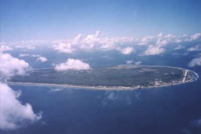 July 23, 2018 Nauru: An 8 Square Mile Island That was Once the World’s Richest Country
The post Tristan da Cunha: The Remotest Inhabited Island in the World appeared first on .
]]>The post What Happens to the Olympic Venues in the Host Countries After the Olympic Games End? appeared first on .
]]>
Abandoned swimming pool at Olympic Village Elstal, Germany. (CarlJohanLinell / Flickr)
Olympic games greatly affect the infrastructure of their host cities, and not necessarily always in a positive way. A great deal of expense is involved in building the state-of-the-art stadiums, pools, tracks, and facilities that are required for the attending sports people, their coaches, fans, members of the media, and other visitors. There is no guarantee, however, that the host city will be able to recoup these expenses after the Olympics.
While some of the venues manage to remain in use for the purpose the organizers built them for, others must perforce get repurposed for completely different sports and activities. Some venues even end up being abandoned and it becomes necessary to demolish them.
The Olympic facilities in South Korea
South Korea hosted the Winter Olympics and Paralympics in 2018. In preparation for this event, they built the 35,000-seat Pyeongchang Olympic Stadium at a staggering cost of $100 million. It is located 180 km southeast of the capital city Seoul in PyeongChang. Once the Olympics were over, there was very little possibility that this enormous stadium might host other similar large-scale events. That being the case, there was really no reason to justify expending the amount of money that was needed for its continued maintenance. So, after much deliberation, the authorities demolished it. It had been used only on four or five occasions. When you compare that with the amount spent on it and the amount needed to demolish it, the whole thing doesn’t make much sense from the financial perspective. There are plans now to construct an Olympic memorial hall in its place.
The Olympic facilities in Brazil
Given its long history for hosting international sports events, it was an easy choice for the Olympics Committee to select Rio de Janeiro to host the 2016 Summer Olympics. Brazil set about building nine new venues and seven temporary venues, with most of the sports events taking place at 18 existing venues.
The Maracanã stadium, the second-largest stadium in South America, was the venue for the opening and closing ceremonies of the Olympic Games. The Brazilians built it for the 1950 FIFA World Cup, and it also hosted the 2014 FIFA World Cup. Additionally, it has hosted many other football championships over the years. Refurbished for the Olympics, it fell into a state of disrepair after the games. The sports authorities renovated it later, and it is now mainly used for football matches between the major football clubs in Brazil.
Some of the temporary venues like the Rio Aquatic Centre now lie abandoned. The Olympic Committee billed the Centre as the model of nomadic architecture techniques, and the local government had plans for it. They intended to disassemble the Centre and build it into two community swimming centres, but, apparently, a lack of funds derailed this conversion.
The Olympic facilities in the UK
London is the first city to have hosted three Olympic Games. The first occasion, in 1908, came about because the games could not be held in Rome as planned. Italy could not afford to host the games anymore. The country needed to divert the finances set aside for the games into the more urgent disaster relief operations after the eruption of Mount Vesuvius in 1906. Hence, the pivot to London to host the Olympic Games.
In London, the Olympic Games took place in 13 venues. The hurriedly-built White City Stadium had tracks for athletics events, with a swimming pool and a raised level surface for wrestling and gymnastics in the centre. The stadium later hosted the 1934 British Empire Games, the 1966 FIFA World Cup, and, between 1927 and 1984, it was a venue for greyhound racing. The stadium was demolished in 1985 and, on the demolished grounds, the BBC constructed a collection of buildings called BBC Media Village to house its offices.
The All England Tennis and Lawn Club, which has been in existence since the 1870s, was the venue for tennis, and it continues to host tennis competitions, including the annual Wimbledon Championship.
After the Second World War, the Olympic Games took place in 1948 and, as a nod to all the devastation and the consequent need for financial sobriety, they were dubbed the Austerity Games.
The economic situation, at this point, was not conducive for building any new venues, and, so, most of the events took at Wembley Stadium and the Empire Pool at Wembley Park. All other events took place in 24 sports grounds used by various clubs. The athletes were accommodated in housing complexes in the Wembley area.
The Summer Olympics of 2012 revitalized London’s East End. The sporting complex constructed for the Olympics is now the Queen Elizabeth Olympic Park, and some of the venues here are still very much in use, surrounded by waterways, gardens, and cafes. The buildings constructed to house the athletes in the Olympic village were converted into apartments. In 2016, the renovated Olympic Stadium became the home ground of the West Ham United Football Club.
The Olympic facilities in Russia
Although Sochi already had training centres for aspiring Olympic athletes, the Russian authorities did not think the facilities were fitting enough to host international competitions. Russia, therefore, spent over $51 billion to construct arenas, ice rinks, and ski slopes in Sochi for the 2014 Winter Olympics. The Sochi Olympics have been the most expensive to date, but Sochi hopes to recover almost all the costs by using the venues for future sporting events.
In 2016, the authorities removed the dazzling snowy peaks roof of the Fisht Olympic Stadium in order to fulfil FIFA regulations to host the 2017 Confederations Cup and 2018 World Cup. Fisht Stadium, as it is now known, is the home of PFC Sochi, a Russian professional football club.
The venue of the ice hockey games was the even more dazzling Bolshoy Ice Dome. It has a silver-coloured aluminium panelled roof that is encrusted with 38,000 LED lights. The hockey team HC Sochi is based there, and it is also used as an entertainment centre and concert hall.
The skiing venues at Rosa Khutor were built 2011 and hosted FIS Alpine Ski World Cup before the Olympics. Rosa Khutor Alpine Ski Resort is being promoted as a ski destination for international tourists.
The Olympic facilities in China
The park that China built for the 2008 Summer Olympics in Beijing’s Chaoyang district is called the Olympic Green. Some of the venues like those for hockey and archery competitions have been dismantled, but most of the other venues are still in use and will be hosting the 2022 Winter Olympics. The National Aquatics Centre, popularly known as Water Cube for its unique cuboid bubble architecture, is where the swimming and diving events were held. In 2010, the interior of almost half of the centre was redesigned to create a water park at a cost of 200 million yuan. It is currently Asia’s largest indoor water park.
The Olympic facilities in Greece
While Greece reportedly went way over budget to host the 2004 Summer Olympics, the infrastructure they built at this time has had a positive impact on the city’s public amenities. The Olympic stadium is the home of the Panathinaikos football club. The venues built for various sports still host various sporting competitions for those sports. Some venues have been converted into public parks. The Ano Liosia Olympic Hall, which built for judo and wrestling, is going to house the Hellenic Academy of Culture and Hellenic Digital Archive. The athletes’ village was turned into low-cost housing complexes.
The Olympic facilities in Norway
Lillehammer in Norway hosted the 1994 Winter Olympics and the Winter Youth Olympics in 2016. All the Olympic venues are still in use. The Lysgardsbakkene Ski Jumping Arena is used all months of the year. It is located in the town and it is where the opening ceremony was held. Lillehammer can be considered as a post-Olympic success.
The Olympic facilities in the former Yugoslavia
Most of the 1984 Winter Olympics sites in Sarajevo, Yugoslavia, survived the Bosnian War of 1992-1995. Local sports enthusiasts are assisting the Olympic Committee of Bosnia and Herzegovina to reconstruct and maintain various sports venues such as the graffiti-adorned bobsled course on Mount Trebevic. In 2010, the main stadium was named Juan Antonio Samaranch Olympic Hall after the seventh President of the International Olympic Committee, and it hosted the 2019 European Youth Olympic Winter Festival.

Sarajevo bobsleigh track. (Gabriel Hess / Flickr)

The abandoned bobsled. (Julian Nitzsche / Wikimedia Commons)
Is it really worth the expense to host the Olympic games?
An increasing number of people around the world are beginning to question the wisdom of spending billions on building the multitude of large venues required for the Olympic Games. Many are of the opinion that it is not worth it for the host country to undergo such expense for venues that may have limited or no use in the future. So, the organizers of the Olympic games must come up with workable schemes that can justify this kind of expenditure.
When it is not possible to use the venues for the sports they were built for, the most common re-purposing method so far has been to remodel the venues to use for hosting some other events or for some other purposes. This, however, is not always possible. From both the reconstruction and cost perspectives, it is rather difficult to re-purpose stadiums that are built in circular shapes. Rectangular buildings such as those built for gymnastics and judo are comparatively easier to reuse.
The more economical choice, though, is to construct temporary structures. The most successful re-purposing has been the turning of the Olympic Villages into housing complexes. The best choice is to decide what infrastructure the host city needs and temporarily retrofit that to use for the games.
Olympic parks were mostly built on empty lands just outside the host cities and that made them inconvenient to be reused for everyday city life. Barcelona was able to successfully regenerate its beach culture and downtown industrial areas after using them as venues for the 1992 Summer Olympics. Since then, the trend has been to locate venues in the centre of the host city, creating an infrastructure that can be easily reused for business and other activities.
When it comes to the cost of the Olympic Games, in addition to the sports infrastructure, the host city must also spend money on building or renovating public transportation, roads, railways, airports, hospitals, security, power grid, and other things. Without hosting the Olympics, it may not have been possible to allocate the budget needed for the building all the infrastructure at the same time. This expenditure can be taken as an investment that helps the host city in the long term.
Still, whatever decision is made, it is important to make it very carefully made and long before even thinking of hosting the Olympics.
Enjoyed this article? Also, check out “Dhanushkodi: Where a Cyclone Ripped Apart an Entire South Indian Town, Rendering it Uninhabited“.
Fact Analysis:
STSTW Media strives to deliver accurate information through careful research. However, things can go wrong. If you find the above article inaccurate or biased, please let us know at [email protected].
RELATED
 February 18, 2019 The Ryugyong Hotel of North Korea: The Tallest Unoccupied Building in the World
 December 12, 2018 Dhanushkodi: Where a Cyclone Ripped Apart an Entire South Indian Town, Rendering it Uninhabited
 March 26, 2019 The Disappearing Aral Sea and its Abandoned Ships
 January 10, 2019 AMARG: The US Plane Graveyard Where Aircraft are Stored, Stripped, Repaired, and Restored
The post What Happens to the Olympic Venues in the Host Countries After the Olympic Games End? appeared first on .
]]>The post McBarge: The Floating Restaurant That McDonald’s Unveiled at the 1986 World Exposition appeared first on .
]]>
McBarge. (© Ruth Raymond / Flickr)
In their long history, McDonald’s had two floating restaurants, Riverboat McDonald in St Louis, USA, and Friendship 500 in Vancouver, Canada. They built the Friendship 500, popularly known as the McBarge, for the 1986 World Exposition on Transportation and Communication. The restaurant was on a 57-metre-long barge that McDonald’s moored in False Creek, which was alongside the exposition grounds. The McBarge was one of the five McDonald’s exhibits at the exposition, and they built it at the cost of $8 million.

Riverboat McDonald in St. Louis, 1999. (48states / Wikimedia Commons)
McBarge, the floating restaurant
Robert Allan Ltd., one of Canada’s oldest consulting naval architectural firms, designed the floating restaurant. They built it as a showcase of future technology and architecture, which was the theme of the exposition. To construct the structure, they used porcelain-dipped aluminium panels, steel, and ferrocement on a pontoon barge.
Porcelain panels provide a very durable cladding whose colours and surfaces are more resistant to degradation in harsh environments. Ferrocement is a thin wall reinforced concrete which has low weight and a long lifetime. Pontoons are tubes that contain a lot of reserve buoyancy which enables the construction of large decks on floating vehicles such as flat-bottomed barges.
The McBarge measured 8,600 square feet on the main deck and 6,800 square feet on the top deck and could seat 1,400 people. In addition to creating a futuristic floating restaurant, McDonald’s wanted to create a bistro style place that was both elegant and affordable and would attract young people in droves.
The restaurant’s interior features included potted plants, wooden floors, merlot-coloured accents, and framed art. The hidden kitchen used a conveyor belt to deliver food to the serving counter. The glass panelled dining areas provided panoramic views of Vancouver, and the staff wore blue and white sailor’s uniforms. Millions of people visited the World Exposition between May and October, and the novelty of a floating restaurant ensured that the McBarge was always packed.
After the world exposition
McDonald’s intended to continue using the McBarge as a floating restaurant after the World Exposition ended, but for a variety of reasons, they were unable to do so. The staff left, and the empty barge remained moored where it had been during the Exposition.
In 1988, the Vancouver government sold the Exposition grounds to Lee Ka-Shing, a Hong Kong-based tycoon, and, in 1991, he told McDonald’s to remove the barge from his property. So, McDonald’s relocated the barge to Burrard Inlet, north of Vancouver.
Eight years later, in 1999, they sold the barge to Howard Meakin, a real estate developer famous for redeveloping Gastown, an old area of Vancouver. As Meakin did not wish to scrap the barge, it remained anchored in Burrard Inlet, neglected and rusting. It did briefly receive some publicity in 2003 when Marvel Entertainment and New Line Cinema used the barge as the lair of the Nightstalkers for the film Blade: Trinity.

Photo of McBarge in 2006. (Taz / Flickr)
The McBarge on Facebook
Around 2009, a few local people began a Save the McBarge Facebook group. The group grew to include thousands of members, and they discussed their opinions about what to do about the barge and shared photographs of the barge. Some of the suggestions they put forward were using the barge as a shelter for Vancouver’s homeless people, as part of a university campus, and, more commonly, for the purpose it was designed for, to be used as a restaurant and bar.
Howard Meakin paid no particular attention to the Facebook group since he had neither started it and nor had he solicited their advice. On the other hand, these Facebook discussions about the fate of the McBarge drew a lot of public attention to the barge and, as a result, a lot of people went to see it and trespassed on to the barge out of curiosity. Some of them vandalized the barge and drew graffiti on its walls.

McBarge in 2015. (Daderot / Wikimedia Commons)
Howard Meakin’s plans for the McBarge
In the same year as the Facebook publicity, in 2009, Howard Meakin proposed the idea of making the barge the centrepiece of a waterfront development project on the Fraser River in the city of Mission. Besides restaurants and pubs, the project called “Sturgeon’s on the Fraser” included plans to build a marina and a seaplane terminal to service flights to Victoria and Nanaimo. Although Meakin’s proposal garnered some local support, the Mission city council rejected it citing environmental issues.
For the next 30 years, the barge remained in Burrard Inlet. Then, in 2015, Howard Meakin moved the now dirty and mouldy barge to Maple Ridge in the north-eastern section of Greater Vancouver. He planned on spending $4.5 million to renovate the barge, which would include removing the McDonald’s decor and giving the barge a new built look. He did not, however, give the public specific details about what he intended doing with the barge.
In 2017, Howard Meakin announced plans to use the McBarge as a deep-sea museum. Along with Phil Nuytten, an inventor and president of the Historical Diving Society of Canada, architect David Eaton, and designer Nigel Walker, Meakin spent more than a year working on the project.
To be named Deep Ocean Discovery Centre, the proposed 15,400 square foot museum was going to have a 4-D theatre and educational exhibits showcasing the history and importance of the Pacific Ocean, indigenous ocean technology and new developments, and stories and experiences of navigating the ocean. The museum would also display Nuytten’s vast collection of underwater equipment and other artefacts such as a shark cage.
As restoring and repurposing the McBarge would require a considerable sum of money, Meakin and Nuytten decided to get the Vancouver City Council involved in the project. They hoped that the City Council would give the barge a Historic Place Status. This designation would have made it easier for them to get funding from government grants and sponsorships. Their petition, however, did not receive the requisite number of signatures. They also planned to launch a crowdfunding campaign to raise some money, but they had to cancel the event in October due to bad weather. After 2017, there have been no further announcements regarding the project.
The McBarge, meanwhile, is still docked in Maple Ridge.
Enjoyed this article? Also, check out “Nakagin Capsule Tower: A Futuristic Building from the Past, Which Might Just Not See the Future“.
Fact Analysis:
STSTW Media strives to deliver accurate information through careful research. However, things can go wrong. If you find the above article inaccurate or biased, please let us know at [email protected].
RELATED
 December 10, 2018 Nakagin Capsule Tower: A Futuristic Building from the Past, Which Might Just Not See the Future
 January 26, 2020 Under ‘Under’, an Underwater Restaurant in Lindesnes, Norway
- December 18, 2019 Punta del Hidalgo Lighthouse: A Celebration of Modern Architecture and Traditional Utility
- June 1, 2020 The Clermont-Ferrand Cathedral: A Beautiful Gothic Structure Made of Black Lava Stone
The post McBarge: The Floating Restaurant That McDonald’s Unveiled at the 1986 World Exposition appeared first on .
]]>The post Neuschwanstein Castle: The Story Behind the Iconic Bavarian Castle That Inspired the Disney Castle appeared first on .
]]>
Neuschwanstein Castle. (Max Pixel)
An imposing Romanesque structure, Neuschwanstein Castle is one of Germany’s most well-known castles. It stands poised on a hill in the Alpine foothills in Bavaria, 120 kilometres to the south of Munich and above the small village of Hohenschwangau. Built as a private retreat in the 19th century by Ludwig II, the King of Bavaria, it looks like something straight out of a fairy tale. If you have seen Sleeping Beauty’s castle in the Walt Disney film, you will notice the similarity with Neuschwanstein Castle. It was the inspiration for the Disney version.
Ludwig II of Bavaria

Ludwig II of Bavaria. (Wikimedia Commons)
In the mainstream media, Ludwig II is often referred to as the Fairy King — for the fairy tale castle he built — and as the Mad King — a diagnosis made by a so-called doctor, who personally never examined him, and which is quite without merit and most certainly a political gambit on part of his opponents to dethrone him and seize power in Bavaria.
For someone who designed and built an enchanted castle, Ludwig II, unfortunately, did not live an enchanted life.
Growing up, he was not close to either of his parents. He was brought up almost entirely by servants and tutors, and it was a strict, even harsh upbringing. There was none of the personal freedom that most young boys of a similar age might take for granted. After all, he was the heir to the Bavarian throne, and he was never allowed to forget that.
In 1864, after the death of his father King Maximilian II, he ascended the throne of Bavaria. He was only 18 years old at the time, with a shy, reclusive personality that was entirely unsuited for the governing of a nation. He tried not to rock the boat by continuing his father’s policies, but he hated public gatherings and attending to court affairs. As much as possible, he took to avoiding these and began spending more and more of his time engaged in creative pursuits.
Four years after his coronation, in February 1868, Ludwig I died – that is, the new King’s grandfather and the former King of Bavaria, who had, years earlier, refused to become a constitutional monarch and had, therefore, stepped down in favour of his son. The former King’s death meant that the considerable sums of money that had, so far, been spent on his estate could now be diverted to other projects. Ludwig II decided to use the money to finance a private retreat that would exemplify the romantic Medieval architectural style.
Contrary to what some media sources reported, he never used public funds for Neuschwanstein Castle or any of his other building projects. Even so, his ministers were angered by his lavish spending on his personal projects and his lackadaisical participation in the country’s politics. He, however, remained popular with the Bavarian public.
The idea of Neuschwanstein castle
Ludwig II grew up in the family castle, Hohenschwangau Castle. Close by, higher up in the mountains, were the ruins of two medieval castles — Vorderhohenschwangau and Hinterhohenschwangau — that greatly fascinated the young Prince. He often went hiking to the ruins and made several sketches of them. The idea of building a castle here along the medieval lines came to him first during this time.
Later, after he became King, he was able to set this plan into motion.
In a letter to Richard Wagner – the great German musician whose magnificent operas Tannhauser and Lohengrin had also played a pivotal role in inspiring him to build the castle – the King expounded on the beautiful environs near Poliat Gorge. The natural scenery, he assured Wagner, possessed a grandeur that seemed straight out of the mythological realm of his operas.
Designing Neuschwanstein castle
Given his passion for Wagner’s operas, it wasn’t surprising that Ludwig II hired Christian Jank, a stage designer and scene painter, to come up with the designs for the proposed castle. He also hired Eduard Riedel, an architect, to render the architectural drawings. He himself remained involved in every step of designing Neuschwanstein Castle. He rejected designs inspired by the Nuremberg castle and asked that the designers look more toward the Wartburg Castle for inspiration. Furthermore, he demanded that the designers present him with detailed designs and insisted on approving every single design draft. His involvement and tight control on the design drafting process meant that it was eventually his own design that was finalized. The castle that was finally built was more his creation than that of the designers.

The front elevation of the castle. (Max Pixel)
The architecture of Neuschwanstein castle
Ludwig II strove for a medieval effect that was mixed with the latest technical innovations of the 19th century. The castle had flush toilets, advanced kitchen gadgets, and electricity.
While Neuschwanstein Castle is much admired for its combination of Romanesque, Gothic, and Byzantine architectural elements in present times, many of the leading Bavarian architects of the period looked upon it as kitsch.
The construction of Neuschwanstein castle
Neuschwanstein Castle took 14 years to build and, in this period, it provided steady employment to a large portion of the local population. The building work began in 1868 with the demolishment of the ruins of the two medieval castles. While Ludwig II had, earlier on, wanted to incorporate the two castle ruins into the new castle, it soon became clear that this could not be possible for structural reasons.
On 5 September 1869, the builders set the foundation stone and worked on finishing the castle cellar. It took them until 1872 to finish that and it was four years later, in 1876, when they completed the castle’s first floor and the gatehouse. While brick was used as the primary construction material, the castle façade was in rock, sandstone, and white limestone. In 1880, the builders held the castle’s topping out ceremony, and, two years afterwards, a portion of the castle was ready and furnished.

Neuschwanstein Castle during construction. (Johannes Bernhard)
Ludwig II moved into the furnished section of the castle in 1884 and kept an eye on the ongoing work. It wasn’t all a smooth progress. There were accidents in which workmen died and, also, the King had several differences with the builders and changed the overseer a couple of times. For instance, the work began under Eduard Riedel, but the King replaced him with Georg von Dollmann in 1874, and, later, he replaced Dollman with Julius Hoffman.
Interesting aspects of Neuschwanstein castle
At the time Ludwig II moved in, only 14 rooms in the castle were completed and furnished. These included his personal suite on the first floor, the Throne Room, the Singer’s Hall, and the Grotto. All these rooms are decorated with elements from Wagner’s operas.
The finished castle is an asymmetrical, elongated building with towers, balconies, turrets, gables, and roof cornices with pinnacles. The gate building facing the east has a red brick facade and the portions facing the court have yellow limestone facades. There is a moat as would befit a real German Knight’s castle, but the castle fortifications are mostly decorative. There was to be a massive keep in the upper courtyard, but only its foundation was built and the rest of it remained unbuilt upon the King’s death.

Neuschwanstein Castle from another angle. (Rob Faulkner / Flickr)
Death of Ludwig II
In 1886, Ludwig II was arrested in his bedroom at night and taken away forcibly in a carriage to Berg Castle. The next afternoon, he and Dr. Bernhard von Gudden, who had arrested him, went for a stroll on the shores of Lake Starnberg. When they didn’t return, the guards went to look for them and found both men dead in waist-deep water. They both appeared to have been strangled.
To this day, nobody knows exactly what happened, although there are many theories. The most popular one is that the King had arranged an escape with some royalist supporters and this, unfortunately, was foiled. The King’s cousin later reminisced about him and said he was eccentric, not mad, and he should not have been treated the way he was.
He was able to spend only 11 nights in his beloved castle.
Visiting Neuschwanstein castle
You can visit Neuschwanstein Castle throughout the year. In fact, you ought to see it in different seasons to get an idea of how beautiful it looks against the changing landscape. Plenty of people have the same idea, however, so expect a crowd when you visit.
Neuschwanstein Castle allows visitors only as part of a group, and you can choose if it is to be a small group or a large one. The guided tours start from Munich and generally last an entire day. In addition to seeing the grand interior of the castle, you can take in the picturesque landscape and the breath-taking panorama of the Alps.
Enjoyed this article? Also, check out “Hochosterwitz Castle: The Medieval Castle in Austria That Remained Impregnable from Enemy Attacks“.
Fact Analysis:
STSTW Media strives to deliver accurate information through careful research. However, things can go wrong. If you find the above article inaccurate or biased, please let us know at [email protected].
RELATED
 February 23, 2019 Project Riese: Hitler’s Shadowy Incomplete Underground Complex that Remains a Mystery
 September 13, 2019 Osamu Tezuka: The Walt Disney of Japan
 March 14, 2019 Hochosterwitz Castle: The Medieval Castle in Austria That Remained Impregnable from Enemy Attacks
 August 3, 2019 Ivan the Terrible: The First Tsar of Russia and His Reign of Terror
The post Neuschwanstein Castle: The Story Behind the Iconic Bavarian Castle That Inspired the Disney Castle appeared first on .
]]>The post The Wallace Line: The Invisible Line of Bio-Diversity in the Indian Ocean appeared first on .
]]>
Wallace Line. (Altaileopard / Wikimedia Commons)
The Wallace Line is an invisible and imaginary line that stretches across the Indonesian islands to demarcate the evolutionary differences of the fauna in that region. It gives us an interesting insight on the biogeographical history of the area.

Alfred Russel Wallace. (London Stereoscopic & Photographic Company)
Alfred Russel Wallace, a 19th-century British naturalist, travelled throughout the Malay Archipelago from 1854 to 1862 in order to study the natural history of that area. While exploring the Indonesian islands, he discovered that the fauna on some of the islands was different from that found to the east of those islands. In fact, the islands such as Sumatra, Borneo, Java, and Bali had animal life that was similar to other parts of Asia. They had tigers, rhinoceroses, tarsiers, and tapirs. On the other hand, the Lombok, Sulawesi, and Timor islands had marsupials, monotremes, tree kangaroos, and racquet-tailed kingfishers that were similar to the animal life in Australia.
The Wallace Line
In 1859, Wallace drew a hypothetical line to demarcate this difference in the fauna. This line started from the Indian Ocean and passed through the Lombok Strait between the islands of Bali and Lombok. It then turned northwards through the Makassar Strait between the islands of Borneo and Sulawesi, passed to the south of the island of Mindanao, and ended in the Philippine sea.
Later, the English biologist Thomas Henry Huxley named this imaginary line the Wallace Line.
The Indonesian islands to the east of the line are referred to as belonging to the biogeographical realm of Wallacea. They are separated from Australia and New Guinea by another imaginary line called Lydekker’s Line, which was delineated by the naturalist Richard Lydekker in 1885. Between these two lines is another line called the Weber Line along which both Asian and Australian fauna and their hybrid species are equally present.
Explanation – The Wallacea biogeographical realm
Starting in the 19th century, European naturalists developed the field of biogeography which is the study of how fauna came to be distributed around the earth over time. Using the presence of fauna as the main indicator, the naturalists divided the earth’s surface into biogeographical realms. Furthermore, they subdivided these realms into ecoregions containing different biomes and habitats. In each realm, the fauna more or less evolved in isolation, completely separated from the fauna of the other realms by natural barriers that prevented them from migrating. The largest natural barriers are the oceans, followed by deserts and mountain ranges. Islands, being isolated, are an easier and more convenient ecosystem for studying biogeography.
Biogeographers use the continental drift theory to explain the distribution of fauna. Until 140 to 175 million years ago, the continents of Asia and Australia were connected. During this period, the indigenous animals could move all across the huge landmass and reproduce. Then the continents started to drift apart, the ocean levels rose up, and the islands of the Malay Archipelago were formed on the continental shelves between the Asian and Australian continents.
A continental shelf is a part of a continent which has sunk under water.
The Sunda Shelf connects Asia with Borneo, Bali, Java, and Sumatra. Australia and New Guinea are connected by the Sahul Shelf to these islands. So, the ocean separated the land masses and this led to the evolution of different animal species on the two continents and on the islands between them over a period of some 50 million years.
During the last ice age, between 70,000 to 40,000 years ago, the ocean levels fell dramatically and opened up land bridges between Asia and the islands and between some of the islands and Australia. At this time, various fauna crossed these land bridges to the islands and roamed across them. However, the ice age soon ended, and the ocean levels rose up to 25 to 125 meters, effectively closing off the land bridges between the islands and the continents. The fauna were thus isolated on the islands that they happened to be on at that time, and, thereafter, they evolved in unique ways by adapting to the environment on these islands. Eventually, they became distinguishably different. These islands form the Wallacea biogeographical realm, and a very large number of endemic species of fauna now live on them.
Wallace’s great discovery
Over 500 islands lie to the east of Bali across the Lombak Strait and these are known to the Indonesians as Nusa Tengagara. From the northern islands of Lombok, Sumbawa, Flores, and Alor, these islands stretch over 1,300 km to the southern islands of Sumba, Savu, Roti, and Timor.
While studying and collecting birds in the area, Wallace noticed that the birds on some of the islands that were close to each other were very different and that the birds on some of the islands that were far from each other were of the same species. This was particularly noticeable on the island of Bali, which had 50 percent different birds from those on the island of Lombok, despite the fact that they were separated by a distance of just 25 km of water. But 97 percent of birds on Bali were present on Java. Also, 75 percent of the birds on Lombok are Asian species, while 14 percent of the birds on Bali are from Australia. Wallace was perplexed by this discovery. What was it that had made the birds that were capable of migrating to and from the islands remained on their respective islands, and why had they evolved in such distinctly different ways over the centuries?
The explanation for this goes back to the ice age when there was a land bridge between Java and Bali, whereas, in the same period, there was a water channel between Bali and Lombok. Some of the birds, being good flyers, crossed the water channel to Lombok and flew further to settle on the eastern islands. Similarly, birds flew from Sumbawa across the Sape Strait to Komodo and from Alor across the Ombai Strait to Timor.
After the ice age ended, when the water channels between the islands deepened and widened, these isolated birds became distinct from those that had remained on Java.
Of the 564 bird species in Nusa Tenggara, 144 are endemic. On the other hand, the island of Sulawesi’s endemic population includes 62 percent of mammals and reptiles, 27 percent of birds, and 76 percent of amphibians. Possums, and marsupials, which are related to kangaroos, crossed the land bridges from Australia to Sulawesi during the ice age. However, these animals could not cross the Makassar Strait to reach Borneo from Sulawesi.
Although there are differences in flora as well along the Wallace Line, they are not as distinctive as the fauna.
Enjoyed this article? Also, check out “Kármán Line: The Hypothetical Line That Delineates the Earth’s Atmosphere from Outer Space“.
Fact Analysis:
STSTW Media strives to deliver accurate information through careful research. However, things can go wrong. If you find the above article inaccurate or biased, please let us know at [email protected].
RELATED
- August 18, 2018 Krakatoa Volcano: An Earth-Shattering Explosion That Ruptured the Eardrums of Many
 January 8, 2019 Proboscis Monkey: The Rare Borneo Monkey Species with an Unusually Long Nose to Lure Its Females
 February 28, 2019 Under the Sea: Do Fishes Dream?
 October 3, 2018 Suspended Animation: Where Bodily Functions Cease, But an Individual Continues to Live
The post The Wallace Line: The Invisible Line of Bio-Diversity in the Indian Ocean appeared first on .
]]>The post Incredible Ta Prohm: The Ancient Khmer Temple in Cambodia appeared first on .
]]>
Temple in Ta Prohm. (© CEphoto, Uwe Aranas / CC-BY-SA-3.0)
One of the most iconic photographs to emerge from Cambodia is that of an ancient temple with huge tree roots draped over it. This is Ta Prohm. In the Khmer language, Ta Prohm means Ancestor Brahma or Eye of Brahma. Dedicated to the mother of the powerful Khmer king, Jayavarman VII, the Ta Prohm temple is in Angkor in the Siem Reap province of Cambodia.
Jayavarman VII, builder of the Ta Prohm temple
Around 1181 A.D., Jayavarman VII (1120-1218) ascended the throne of the Khmer Empire and soon established himself as the most powerful monarch of the dynasty. He ruled for 37 years and was a strict adherent of the Mahayana Buddhist faith. After successfully repulsing the attacks by the Vietnamese Chăm Pa Kingdom between 1171 and 1181, Jayavarman VII began rebuilding his war-ravaged capital Angkor. He embarked on an intensive construction program to erect public buildings and religious monuments that would benefit his subjects.
He built the walled city of Angkor Thom near the ruins of the ancient capital Yaśodharapura and included some of the extant buildings of the earlier period into his palace complex. Amongst the other buildings, he constructed was a Mahayana Buddhist monastery and university to the east of Angkor Thom. The temple of Ta Prohm was consecrated in 1186 and the temple of Preah Khan was consecrated in 1191 to honor his mother Queen Sri Jayarajacudamani and his father King Dharanindravarman II, respectively.

Ta Phrom, Angkor. (Diego Delso / CC-BY-SA-4.0)

Nature taking over the Temple in Ta Prohm. (Diego Delso / CC-BY-SA-4.0)
At this time, Ta Prohm was known as Rajavihara, meaning monastery of the king. For over three centuries, the Khmer rulers continuously added to and expanded the temple complex. The site was a lively cultural centre. Various steles inscribed with Sanskrit inscriptions provide information about life at Ta Prohm temple. Along the date of the temple’s consecration in 1186, the steles detail its inhabitants. Around 12,640 people lived in the temple, including 18 priests, 615 dancers, 2740 officials, and 2202 assistants. There was also a staff of 79,365 to maintain the temple complex.
Towards the end of the 15th century, the Khmer Empire collapsed from a combination of different factors such as internal discord, the rise of Shaivism and Theravada Buddhism, wars with the Thai kings of the Ayutthaya Kingdom, collapse of commerce, neglect of public works, ecological disasters such as flooding, and the plague. Angkor and its temples, except for Angkor Wat, were abandoned. The surrounding jungle soon reclaimed Ta Prohm. Green moss began to creep over the stone walls. Strangler fig, kapok or silk-cotton, banyan, and other trees extended their roots and spread their branches throughout the temple complex.

Roots of Tetrameles nudiflora around the entrance of the temple. (Diego Delso / CC-BY-SA-4.0)
Restoration of the Ta Prohm temple
Ta Prohm was not completely forgotten, of course. Curious locals and intrepid explorers continued visiting it. At the end of the 19th century, the French explorer and artist, Louis Delaporte, popularised Angkor with his illustrations of Khmer architecture and art. This inspired French archaeologists to attempt to restore the magnificent monuments of Angkor. At the beginning of the 20th century, the École Française d’Extrême-Orient led the efforts to conserve and restore the temples of Angkor. They found the intertwined stone and tree structures of Ta Prohm picturesque and decided to leave them as they were.
It was necessary, however, to carry out some restoration work to strengthen the foundations and stop further deterioration of the ruins. To protect the area from waterlogging, they also installed drains.
The Archaeological Survey of India, in partnership with APSARA (Authority for the Protection and Management of Angkor and the Region of Siem Reap), has reconstructed some parts of the temple complex. They cleared paths through the jungle to allow entry from the west side and exit from the east. Some areas of the temple are scattered with the remains of sculptures and balustrades and are impassable. Wooden walkways and platforms with roped railings were installed in the accessible areas to limit damage from visitors.

Ta Prohm, Cambodia. (Diego Delso / CC-BY-SA-4.0)
The architecture of the Ta Prohm temple
Ta Prohm’s architecture is in a flat Khmer style, and the entire temple was built without the use of any type of mortar. The temple complex is set closer to the western side of the enclosure wall and faces towards the east. All the low temple buildings stand on one level. The temple has a central sanctuary which contains the stone statue of the main deity, Prajnaparamita, the personification of wisdom. This deity was supposedly modelled after the king’s mother. The central sanctuary is surrounded by five enclosures that get progressively larger. The outermost enclosure has dimensions measuring 1,959 by 3,281 feet.
There are 260 lesser deities housed in sanctuaries surrounding the central one. The tower of the central sanctuary forms the centre of a quincunx with the corner towers of the first enclosure. The first, second, and third enclosures have galleries. In the third enclosure, there are two temples; the one in the northern side is dedicated to the king’s guru, Jayamangalartha, and, the one in the southern side, to the king’s elder brother. There were moats on both sides of the fourth enclosure. The fifth enclosure is said to have been the site of a town which housed thousands of people who managed and maintained the temple.
In the 13th century, the Khmer rulers enhanced the gopuras – that is, the ornate entrance towers at each of the four sides – with face towers like those at the Bayon temple. The gopuras of all the enclosures are connected by passages leading to the central sanctuary. Most of the buildings in the inner enclosures were later additions. These include dance halls and libraries.
Not many of the stone carvings and bas reliefs at Ta Prohm have survived to this day. The successors of Jayavarman VII did not share his belief in Mahayana Buddhism and had no interest in preserving the artwork at Ta Prohm. Jayavarman VIII, in particular, was notorious for destroying Buddhist relics created during the reign of his predecessors.
Some of the bas reliefs depicting scenes from Buddhist mythology can still be seen on the temple walls. One such scene shows Prince Siddhartha, who eventually became known as the Buddha, departing from his father’s palace to lead a life of asceticism. There are also some remains of stone carvings of female deities, meditating monks, temple guardians, and apsara dancers. Images of the Buddha can be seen in niches along the inner wall of the passage leading to the first enclosure.
The king ordered the construction of 566 clusters of stone houses, 286 brick houses, and 3,140 villages. The details of the temple’s wealth are also impressive. There were 500 kilograms of golden dishes, 35 diamonds, 40,620 pearls, 4,540 precious stones, 876 veils from China, 512 silk beds, and 523 parasols. Some people speculate that this information may have been vastly exaggerated to glorify the king.
The Stegosaurus of Ta Prohm
One rather intriguing thing at Ta Prohm is a wall carving of a Stegosaurus. At least, it looks very much like a Stegosaurus, and that has led quite a few people to conclude that perhaps the stone carver might have seen one alive in the 1180s or earlier. This is a strange logic, as there are also representations of mythical creatures on the temple walls and nobody has yet suggested that the stone carvers saw those live as well. In any case, the carving might very well be that of a rhinoceros or a chameleon.

Carving of an alleged dinosaur at Ta Prohm Temple. (Harald Hoyer / Flickr)
Ta Prohm, the World Heritage Site
UNESCO listed Ta Prohm as a World Heritage site in 1992. Ta Prohm remains one of the most popular temples in Angkor. Visitors are left mesmerised and awestruck by its serene beauty, especially in the early morning light. They are more fascinated by the sight of the majestic Spung trees that continue growing as one with the stone ruins, and this photogenic scenery is the main attraction of this temple.
Enjoyed this article? Also, check out “Batu Caves of Malayasia – The Largest Shrine to Lord Murugan Outside India“.
Fact Analysis:
STSTW Media strives to deliver accurate information through careful research. However, things can go wrong. If you find the above article inaccurate or biased, please let us know at [email protected].
RELATED
- May 12, 2019 Cambodia’s Magnificent Angkor Wat: One of the Largest Religious Monuments in the World
- September 21, 2019 Batu Caves of Malayasia – The Largest Shrine to Lord Murugan Outside India
- June 14, 2019 Padmanabhaswamy Temple: The Richest Temple in the World with Gold Worth $22 Billion in Six Vaults
- July 17, 2019 The Lonar Lake: An Astronomical Marvel
The post Incredible Ta Prohm: The Ancient Khmer Temple in Cambodia appeared first on .
]]>The post Space Advertising: The Race to Advertise in Outer Space appeared first on .
]]>
NASA astronaut Dale A. Gardner jokingly holding a “For Sale” sign for the satellites behind him. (NASA)
Outer space begins from just over 80 km above the earth’s surface. For advertisers, it is the final frontier for capturing and holding consumer attention. People around the world have grown accustomed to and jaded about seeing or hearing advertisements in all the usual places – television, radio, movies, roadside banners, billboards, magazines, books, and so on. They may even ignore these advertisements with repeated viewing.
Advertisers hope that it won’t be the same case if they start advertising in outer space. Although, if you really think about it and consider human nature, there is no reason why the outcome should be any different. It is true that an advertisement spread out in outer space will have a wider reach. It may be seen by billions of potential consumers, no matter where they are located on the planet, no matter if they have digital or electronic devices or not.
Advertising attempts in outer space
There were plans to put up lights on a formation of satellites in the low earth orbit to mimic a billboard, but these were shelved for various reasons. The illumination from the advertisements would have shone as brightly as the moon, obstructing astronomical observations. There would have been an on-going risk of collision with other satellites, spacecraft and also the risk of being hit by meteorites. Such collisions could lead to the adding problem of space debris.
There were objections from the public as the advertisements would have been too obtrusive to avoid, being always visible high above to the naked eye. Such advertisements would also be very expensive to create and launch and technologically difficult to change often.
In 1993, the United States-based company Space Marketing Inc. attempted a space billboard project that flopped. Since then, no other company has attempted what many people consider to be a ludicrous idea. Even so, the US government has banned all billboard advertisements in outer space that can be seen without the aid of telescopes and other devices. There are also several international organizations that are campaigning to put limits on obtrusive space advertising.
Some outlandish outer space advertising
The French Ring of Light project, meant to celebrate the 100th anniversary of the Eiffel Tower, would have competed with the moon for sheer brightness. The project was to have an inflatable ring with a circumference of 24 km and this ring would have had reflective Mylar balloons attached to it at various points. If the project had been carried out, the organizers would have launched the ring to a height of over 800 km. Fortunately, the project was abandoned and will not be ruining our view of the moon.
Meanwhile, Coca-Cola and Google proposed to use the moon itself as a billboard. They planned to use high-powered lasers to beam their logo onto to the moon’s surface. Technological and legal challenges ended those plans.
Then there was the Znamya project that many people considered to be an advertisement for the Russian space agency. The project launched satellites to direct sunlight to the Arctic area and these satellites also to lit up some areas of Europe. The Znamaya 2.5 project, which could have lighted up areas in the US, was abandoned after it failed to launch.
Outer space advertising successes
Advertising by product placement and publicity stunts have seen some success in the outer space advertising arena.
In 2000, Pizza Hut bought advertising space on the unmanned Proton rocket that Russia launched to carry the Zvezda module to the International Space Station. The new 30-foot Pizza Hut logo was painted on the side of the rocket and got the company noticed by a lot of people around the world. The next year, Pizza Hut delivered a 6-inch salami pizza in a vacuum-sealed container to the International Space Station. The first pizza to be eaten in space had to undergo several rounds of testing to meet space food standards. The free press coverage of the event and the details of all the planning and preparation for it was worth millions of advertising dollars to Pizza Hut. Plans to develop an outer space food delivery service are, however, nowhere in sight.
Other famous publicity stunts involved Kodak having their logo and a slogan painted on the durability testing material on the outside of the International Space Station and Pepsi having a cosmonaut float a replica of their soda can outside the Russian Mir space station. The cost of these stunts varied from half a million dollars to over five million dollars.
The Japanese reporter, Toyohiro Akiyama, was the first journalist to go on a spaceflight in 1990. The Tokyo Broadcasting System (TBS) paid around $10 million to the Russian space agency to send him on the Soyuz TM-11 expedition to the Mir Space Station. TBS also had their logo painted on the Soyuz rocket. Aware that TBS would receive enormous publicity from this, other companies like Sony, Otsuka Pharmaceutical, and Unicharm also availed of the opportunity to place their logos on the launch shroud of the rocket.

Elon Musk’s Tesla Roadster in space. (SpaceX)
In February 2018, Elon Musk’s Tesla Roadster was selected as a dummy payload on the Falcon Heavy rocket when SpaceX launched it for a test flight. The rocket put the car into a heliocentric orbit. The onboard camera provided a livestream of the event for over four hours and millions of people viewed it. It turned out to be a great marketing stunt for Tesla’s cars as well as publicity for SpaceX’s space exploration ventures.
Advertising related to outer space
The 1960s and 1970s saw brands like Pillsbury and Tang promoting their products as being used by astronauts in outer space.
In 2015, the South Korean carmaker, Hyundai, released an online video showing 11 Genesis cars making an image with their tire tracks on the Delamar dry lake bed in the Nevada desert. The image spanning 5.5 square kilometres was filmed by the company to be a message from a daughter to her father who saw it from the International Space Station. The millions of views that this emotional story got increased Hyundai’s brand value.
The Axe brand of Unilever SA, assisted by the astronaut Buzz Aldrin, held a contest in 2013 to give people a chance to book seats on commercial space flights organised by the Netherlands-based Space Expedition Corp.
Legality of advertising in outer space
The 1967 Outer Space Treaty states that activities planned in outer space, which includes the moon and other bodies in space, should not cause any harm or interfere in the peaceful exploration of outer space. There are no specific laws regarding using satellites or the moon or anything else in outer space for advertising purposes. Other than the US ban on obtrusive billboards, there are no national laws regulating advertising in the space industry. The advertising business has laws relating to how true the claims made by advertisers about their products are, but there are no laws about how true the stories used to sell the products can be. It may be possible for companies to use laws about unfair competitive advantage to prevent other companies from using outer space as an advertising medium.
Future of outer space advertising
Individuals and institutions, who participate in competitions for developing space vehicles such as Google Lunar X PRIZE, plan on getting the necessary funding from sponsorship deals with large international brands. Private space exploration companies, as well as national space programs with increasingly limited budgets, are also looking at ways to raise funds. The success of some of these publicity stunts may encourage them to get funding from consumer product companies willing to pay for delivering their own branded products into outer space.
Other companies can pay to have their logos placed on equipment used on spacecraft and satellites. Companies can also launch their own branded payloads into the International Space Station, film the launch and distribute the video online to get publicity for their experiments and research. This type of advertising is still very expensive, however, and is not likely to become ubiquitous anytime soon.
Advertisers are always on the lookout for unique and entertaining ways to market products and services, and no one can predict what forms of advertising could become possible in outer space.
Enjoyed this article? Also, check out “Space Burial: Making Skies Our Cemetery“.
Fact Analysis:
STSTW Media strives to deliver accurate information through careful research. However, things can go wrong. If you find the above article inaccurate or biased, please let us know at [email protected].
RELATED
 February 15, 2019 NASA’s Deep Space Network: How We Communicate with Space Probes Billions of Miles from Earth
- February 26, 2019 Skylab: The Space Station that Failed in Spite of Brilliant Conception and Brave Execution
- October 21, 2018 Did Man Really Land on Moon? The Dilemma of Apollo 11’s Missing Tapes
 September 27, 2018 Truth Behind The Black Knight Satellite Conspiracy Theory
The post Space Advertising: The Race to Advertise in Outer Space appeared first on .
]]>The post How Air India Carried Out the World’s Largest Civilian Evacuation in 1990 appeared first on .
]]>
File photo of Air India. (Caribb / Flickr)
When Iraq invaded Kuwait on 2 August 1990, the Indian expatriates in the latter country were left without the means to leave from the war zone. The Indian government sprang into action to rescue their citizens. Over a period of two months, between 14 August 1990 and 11 October 1990, Air India evacuated over 170,000 civilians from Kuwait and Iraq. It was the world’s largest civilian evacuation in history.
Iraq’s invasion of Kuwait
There were several reasons for Iraq’s invasion of neighbouring Kuwait. Iraq believed that Kuwait was purposely keeping its petroleum production at high levels to lower Iraq’s petroleum revenues. Further, Iraq was convinced that Kuwait was stealing its petroleum to the tune of $2.4 billion through slant-drilling across the international border into Iraq’s Rumaila oil field.
Kuwait, on its part, was unwilling to forgive the $15 billion loan it had given Iraq to finance its war with Iran between 1982 and 1988.
As a result, diplomatic relations between the two countries grew strained, and Iraq’s solution to the problem was to annex Kuwait. The Kuwaiti armed forces were unable to counter the Iraqi army’s assault, and, within two days, Iraq was able to proclaim Kuwait to be the 19th province of Iraq.
The Indian expatriates in Kuwait
The high-income economies of the Persian Gulf countries, particularly Kuwait and Iraq, had long attracted highly-qualified Indian professionals. Engineers, management consultants, and retail traders, as well as labourers, flocked to these countries to work in the booming construction industry. Most of these people were from the southern Indian state of Kerala. By 1990, the Indian expatriates constituted a significant community in Kuwait, and many of them had lived there for more than a decade, some even for several generations.
They did not at first comprehend that the impact of the Iraqi invasion would unsettle their lives. The Iraqis had traditionally had friendly relations with Indians, and so the presence of the Iraqi army did not pose a threat to the lives of the Indians in Kuwait. However, the breakdown of the Kuwaiti civilian government left the people at the mercy of thieves and armed looters. Soon, there was food scarcity everywhere in the country and water and electricity were also in short supply. These factors put an end to the illusion of normalcy.
As the Iraqi occupation continued, the Iraqis began to indiscriminate against and harass non-Kuwaitis. They jailed them for not getting Iraqi residence permits and Iraqi registration for their cars. By the time the realisation dawned on the Indian expatriates that it was no longer safe for them to continue living in Kuwait, it was too late to make a planned exit with all their possessions. They had to flee, some with only the clothes they were wearing, leaving their homes, their belongings, and everything else that they had worked so hard for over the years. For some people, even leaving with nothing became problematic as their employers had their identity documents, and, in the reigning chaos, they could not find or contact them.
The Indian Government assumes responsibility
The governing Kuwaiti royal family had fled to Saudi Arabia at the beginning of the Iraqi invasion, and there was now an Iraqi-appointed government in Kuwait. Since the government of India took it upon itself to bring its citizens safely back home, it had to negotiate with Iraq for their transfer.

Inder Kumar Gujral, the then Minister of External Affairs. (Biswarup Ganguly / Flickr)
The government sent I.K Gujral, the then Minister of External Affairs, to Baghdad to assure the Iraqi authorities that India’s only concern in the conflict was the safety of its citizens. Mr. Gujral met with Saddam Hussein, the Iraqi President, to discuss the situation as well as to discuss the bilateral trade relations between India and Iraq in the backdrop of the blockade by Western countries.
Getting the necessary air space clearances to use military aircraft to transport a large number of people was a cumbersome process, so civilian aircraft were the only option. It was, however, not possible to use the airports in Kuwait and Iraq as the Iraqi government had banned all incoming and outgoing flights.
Eventually, the Jordanian authorities agreed to allow India to operate flights out of Amman for the evacuation, and India’s national airlines Air India and its domestic counterpart Indian Airlines headed for Amman.
The task of organizing the entire operation fell upon M P Mascarenhas, who was Air India’s regional director in the Gulf & Middle East. He and his Air India team conducted the operation from a small hotel room in Amman. The Indian Embassy and the Ministry of External Affairs called for emergency assistance from its officers in India, Lebanon, and Bahrain to process the passports of the evacuees and to issue travel documents to those who needed them. The local Jordanian authorities helped the Indians in the evacuation operation with customs officials resolving the identity problems that cropped up at the border crossing.
Largest civilian evacuation
After the Indian embassy announced the government’s decision to undertake the evacuation, an exodus began towards Amman. Those who had vehicles and could get fuel started on the road to Amman. Every day, over the next two months, thousands of Indian nationals crossed Iraq to reach Al Ruwishied, the solitary outpost on the border between Iraq and Jordan.
When Iraq issued a directive to all diplomats to leave Kuwait, forcing the Indian embassy staff to relocate to Basra in Iraq, some Kuwait-based Indian businessmen, like the Malayali entrepreneur Mathunny Mathews and the architect Harbhajan Singh Vedi, formed the Indian Citizens Committee to coordinate the evacuation operation.
Shaji John Verghese, an electronics engineer, helped to set up a clandestine ham radio in the Indian school in Salmiya, a middle-class suburb in Kuwait. Through the ham radio, the Citizens Committee was able to communicate with the Ministry of External Affairs in Delhi and the Indian ambassador in Baghdad. They got approval from the Iraqi authorities and transporters to use buses to transport people from Kuwait via Basra and Baghdad to Amman in Jordan. The problem was the limited number of available buses, far too few to fit the entire gathered mass of desperate people.
Many of the evacuees that arrived in Amman crowded into the compound of the Indian embassy there. They waited on the embassy lawns, rolling out rugs and mattresses and even erecting makeshift tents. Others camped in the airport and the more fortunate found rooms in the local hotels. Tempers were frayed all around from the anxiety of their ordeal, from the lack of proper sleep, food, and water, and from not knowing exactly when they would be able to secure flights back to India.
In the end though, despite all the problems, the Indian government managed the whole operation with resounding success. It took around two months and 488 flights to transport over 100,000 people from Amman to Bombay. No other country had ever attempted a civilian evacuation of this magnitude before and Air India made it into the Guinness Book of World Records as the only civil airlines to have evacuated so many people.
As unrest erupted further in the Middle-East in the coming years, India was to undertake a few more mass evacuations to bring Indian nationals out of strife-ridden regions.
Enjoyed this article? Also, check out “Battle of Saragarhi: When 21 Valiant Indian Soldiers Held Their Ground, Fiercely Fighting Against Thousands of Afghans“.
Fact Analysis:
STSTW Media strives to deliver accurate information through careful research. However, things can go wrong. If you find the above article inaccurate or biased, please let us know at [email protected]
RELATED
- December 19, 2018 Battle of Saragarhi: When 21 Valiant Indian Soldiers Held Their Ground, Fiercely Fighting Against Thousands of Afghans
 February 27, 2019 IAF Mirage 2000: The French-Made Fighter Aircraft that Answers India’s Call of Duty
 June 19, 2019 Hyderabad State: When Nizams Held Control of an Indian Kingdom During Its Golden Period
 July 3, 2019 The Bengal Famine of 1943: The Man-Made Famine That Killed Around 3 Million Indians
The post How Air India Carried Out the World’s Largest Civilian Evacuation in 1990 appeared first on .
]]>The post The Wave in Arizona: A Geological Wonder appeared first on .
]]>
The Wave, Arizona. (Gb11111 / Wikimedia Commons)
The Vermilion Cliffs National Monument is located between the two states of Arizona and Utah in the USA and boasts a fantastic landscape of mesas, buttes, and canyons. The most amazing feature in this area is the colourful sandstone rock formation on the slopes of the North Coyote Buttes. It looks like an ocean wave and that is why it is called the Wave. Ever since it figured in a German documentary film called ‘Fascinating Nature’, the Wave has become a popular tourist attraction.
How the Wave in Arizona was formed
The Wave’s origins go back to 145 to 200 million years ago, during the Jurassic period. At this time, layers of sand sandwiched laminae deposits made up of thin layers of sedimentary rock, organic tissue, and other materials. The sand lithified to form cross-bedded sandstone, and this sandstone compacted the laminae within it.
Over the centuries, a natural fracture in this Navajo sandstone eroded into wavy, undulating troughs that intersect each other. The flow of rainwater started the erosion of the sandstone along its joints and deposited minerals such as iron oxide, manganese, and calcium into the gently rounded troughs that began to form in the sandstone. The chemical reaction of the deposited minerals with the sandstone produced a stunning range in colours of white, yellow, orange, red, and purple hues.

Close up photo of the Wave rock formation. (Alex Proimos / Wikimedia Commons)
The largest troughs are 62 feet wide by 118 feet long and 7 feet wide by 52 feet long. At these dimensions, the troughs are now less affected by rainwater flow and face more erosion by wind and sand.
The erosions in the sandstone have exposed rhythmic and cyclic alternating grain flow and laminae. These indicate how changes in wind patterns blew and settled sand in striations.
Compacted sand made of different grain sizes with each having a different resistance to erosion. This enables the formation of thin ridges and ribbing in the sandstone in the direction in which the wind is blowing. In some areas, the laminae are deformed, and researchers speculate that this may be on account of dinosaurs trampling on these laminae.
Visiting the Wave
The Wave is a photographer’s delight. The contrasting colours of the multi-hued sandstone against the blue sky make a beautiful picture. It is best to take photographs around noon as there are no shadows at this hour.

A tourist at the Wave. (mark byzewski / Flickr)
If you are lucky enough to visit after a rainstorm, you are likely to get some amazing photographs of the reflections bouncing off the numerous pools that form in the troughs.
You can visit the Wave all year round, but the most popular months are April, May, September, and October. There are comparatively fewer visitors during the winter months from December to February.
Visitor permits for the Wave
The Bureau of Land Management administers the Coyote Buttes area, and they provide the permits you need to enter the area. The permits cost $7 and you can get them in two ways, either through a walk-in lottery system or through an online lottery system. The Bureau instituted the lottery system to ensure that everyone who wanted to visit got a fair chance to obtain the limited number of permits. As the rock formations are rather fragile, they allow only 20 visitors per day.
The Grand Staircase-Escalante National Monument visitor centre in Kanab, Utah, dispenses 10 permits every day to people who come to the centre. There is no application fee. The permits are valid for the next day.

The Wave rock formation near Page, Arizona. (mark byzewski / Flickr)
From November 15th to March 15th, they draw the lottery for permits on Friday, allowing you to visit on Saturday, Sunday, and Monday. You can avail of ten permits online four months in advance of the date of your proposed visit. The application fee is $5 per person or for a group of up to six people, and it is non-refundable. Each person in the group can apply only once a month and can select up to three dates. People who get a permit receive a notification to pay the $7 permit fee.
Hiking to the Wave
The only way to see the Wave up close is to hike to it. The hiking route to the Wave begins at the Wire Pass trailhead. It is located along House Rock Valley Road, a dirt road that is impassable in wet weather. Turn off Route 89 and drive for about 13.4 km to get to the trailhead parking space. From the Wire Pass trailhead, hike around 4.8 km across open desert to reach the Wave. Another entry point to the Wave is the Notch, but the route is not well mapped and it may not be safe to hike along it.

Wire Pass Trailhead, Utah. (Dereck Bradley / Flickr)
The hike from the Wire Pass trailhead is quite difficult too, and people have died while hiking there. The visitor centre provides a map and information about how to reach the Wave to people who have got permits. Along with the map, you will also need a compass or a GPS. If you have shaky navigation skills, you should hike with a group or hire an authorised guide. There is no cell phone service in the area, so there is no way to call for help if you are on your own and get into trouble.
Before setting off, equip yourself with strong hiking shoes, sun protection gear, and a water bottle. Gird yourself mentally and physically to endure fierce winds, blowing sand, and very little shade. It is a good idea start hiking at dawn to reach the Wave and then spend the entire day viewing it and the surrounding area. To the west of the Wave, there is a similar rock formation at the base of a steep cliff. It is called the Second Wave and, although it is not as colourful as the Wave, it is still worth a look. It is advisable to start the hike back just after sunset.
If you would rather view the Wave from above, you can charter a helicopter or an airplane in Kanab.
The Wave provides a valuable insight into the geological processes that formed the Colorado Plateau. Apart from the fascinating science of the formation of the rocks, do visit the Wave to admire the wondrous creations of nature in a beautiful and serene environment.
Enjoyed this article? You would also love “Australia’s Wave Rock“.
Recommended Visit:
The Wave | Arizona, United States
Fact Analysis:
STSTW Media strives to deliver accurate information through careful research. However, things can go wrong. If you find the above article inaccurate or biased, please let us know at [email protected].
RELATED
 March 2, 2019 Wave Rock: Where a Massive Prehistoric Wave, Just About to Break, is Etched Permanently in Stone
- March 23, 2019 The Moeraki Boulders of New Zealand: Naturally Formed Spherical Boulders from the Paleocene Era
 February 5, 2019 White Sands National Monument: Ace Military Testing Area and an Astounding Tourist Destination
- August 31, 2020 Ennedi Plateau and Aloba Arch: Home to Exquisite Natural Formations and ‘Extinct’ Animals
The post The Wave in Arizona: A Geological Wonder appeared first on .
]]>The post The Manchineel Tree: One of the Most Toxic and Dangerous Tree in the World appeared first on .
]]>
The fruits and leaves of manchineel tree resemble that of an apple tree. (Anne and David / Flickr)

A sign warning people to avoid contact with the manchineel tree. (Will Pollard / Flickr)
If you go to the Caribbean or to the regions around the Gulf of Mexico, you may come across thick clusters of mangroves along the shoreline. Amongst these trees, there will be the infamous evergreens known as the manchineel tree. The infamy comes from the fact that every part of this tree is extremely poisonous. All parts of the tree, including its bark, leaves, flowers, and fruits, contain toxins, some more powerful than others and some that have still not been identified. Coming in close contact with the tree can result in serious injuries and even fatalities. In many areas, the Manchineel trees are therefore painted with a red cross or a red band, along with notices to warn people to stay away from them.
The manchineel tree
The tree gets its name from manzanilla, which is Spanish for little apple. Spanish-speaking locals call it la manzanilla de la muerte or el arbol de la muerte, which, respectively, mean the little apple of death and the tree of death. Other popular names for the Manchineel are beach apple and poison guava. As the names might indicate, this isn’t a tree that the locals love and adore.
The Latin name for the Manchineel is Hippomane mancinella, and it belongs to the Euphorbiaceae or Spurge plant family that is spread all around the world in a variety of forms, ranging from shrubs to very tall trees. It may surprise you to know that the much-reviled Manchineel tree is a close relation of the popular Poinsettia. All plants of the Euphorbiaceae family have toxic sap. The level of sap toxicity varies, however, and the sap from some of the plants can be used for medicinal purposes; this is how Euphorbiaceae plant family came to be called Spurge, which is derived from the word purge, a reference to the laxative properties of the sap.
Physical characteristics of the manchineel tree
A flowering, evergreen, and a round-crowned tree that can reach up to 50 feet in height, the Manchineel has a reddish-grey bark and a trunk that can be around two feet in diameter. It has long-stalked, shiny, and elliptical leaves that are yellow-green in colour and about 10 centimetres in length. The leaves are simple, alternately arranged, and have serrated edges. The Manchineel produces small greenish-yellow flowers that appear in spikes. The fruit of the Manchineel resemble apples and are green or greenish-yellow when ripe. The hard stone inside the fruit contains six to nine seeds.

The manchineel tree. (Marianne Serra / Flickr)
Habitat of the manchineel tree
The Manchineel trees grow in sandy soil along the coast and in mangroves in brackish water and its deep-set roots are excellent for preventing soil erosion. It also serves as an effective windbreak.
Its habitat extends from the Caribbean to Northern, Central, and Southern America. In Florida, you will find the Manchineel in the mangroves of Flamingo in the Everglades National Park and around the Elliott Key and Key Largo islands. It is an endangered tree in the USA as most people would rather eradicate it than have such a toxic neighbour and also on account of rapid habitat loss.
The toxicity of the manchineel tree
While the Manchineel tree contains a variety of toxins, only some such as hippomanins, sapogenins, mancinellins, and physostigmines are known. Researchers still have to identify the others. Some of the toxins have an instantaneous effect, while others are slow to act.
The tree’s milky sap contains the organic compound, phorbol, of the diterpene family of esters. It is so toxic that even a drop of it on your skin can cause burns, blisters, and inflammation. The phorbol is also highly soluble in water. For these reasons, it is not advisable to stand under the Manchineel, and especially not when it rains. Contact with the sap can cause headaches, dermatitis, severe breathing problems, and eye-related problems.
The sap is so toxic; it can damage the paint on cars. Even burning the tree is dangerous as the smoke can poison you if you inhale it and it can also temporarily or permanently blind you.
As you might expect, the Manchineel fruits are not recommended for eating. While there are no reported deaths in recent times from eating the fruits, they could potentially be fatal. They are certainly hazardous enough. According to people who have tried them, the fruits taste delicious at first and then start to taste bitter and peppery. The person then experiences a burning sensation in the throat and the throat swells up and makes swallowing difficult. The pain is excruciating and can last up to eight hours. The person may suffer from gastroenteritis, bleeding, vomiting, shock, digestive tract damage, and bacterial infection. It may be necessary to hospitalize them. Some of the Manchineel toxins may even cause cancerous tumours.
Reason for the manchineel’s toxicity
Botanists remain mystified about why the Manchineel tree is so toxic to humans, animals, and birds. Only the iguana Garrobo (Ctenosaura similis), a striped, black-spined reptile of Central and South America, is known to eat the fruits and sometimes reside in the tree.

Ctenosaura similis. (Christian Mehlführer / Wikimedia Commons)
If you consider the issue from the evolutionary point of view, it is rather strange. Generally speaking, trees want other creatures to eat their fruits and thus help it to disperse and propagate their seeds. Since the Manchineel is so poisonous, there is no question of birds or mammals scrambling to eat it. How does it disperse its seeds then? In the same manner as the coconut tree. As the trees grow on coastal shores, they can easily drop their fruits into the water. These are then carried away by the water current and end up on another shore. The water rots the outer covering and the seeds germinate in the water-logged sandy soil and new plants spring up.
Uses of the manchineel tree
Despite its toxicity, the Manchineel tree is used to make furniture. The tree is burned at the base to topple it; you shouldn’t try cutting it with an axe as that can get the sap all over you. The cut wood is left to dry in the sun for several days to get rid of the toxic sap. Even so, it is necessary to be extremely careful while working with the wood. Wearing a mask is a must to avoid inhaling the sawdust.
Local people have traditionally used the Manchineel toxins from the dried fruits and extracted tree gum to make diuretics and medicines for edema.
In historic times, they used the Manchineel leaves to poison enemy water supplies and the Manchineel sap to tip their arrows for use in warfare. The Spanish conquistador Juan Ponce de León died after being shot with an arrow tipped with Manchineel in battle with the Floridan Calusa tribe. He first came to Florida in 1513 and then returned to seize it for Spain in 1521. His colonization attempt, however, did not go as expected. He met with fierce resistance from the Calusa warriors. One of them shot the sap-tipped arrow into Ponce de Leon’s thigh. The conquistador and his troops fled to Cuba and he died there on arrival.
Avoid the manchineel tree
It is not without reason that the Guinness Book of World Records has rated the Manchineel tree as one of the most dangerous trees in the world. If you should happen to encounter one, stay as far away as possible. This isn’t a tree you want to get up close and personal with.
Enjoyed this article? Also, check out “Rainbow Eucalyptus: A Stunning Demonstration of Nature’s Vibrant Art“.
Do you have a story for us?
We welcome your contribution at [email protected]. Please include your name, city, state, and country.
Fact Analysis:
STSTW Media strives to deliver accurate information through careful research. However, things can go wrong. If you find the above article inaccurate or biased, please let us know at [email protected].
RELATED
 August 30, 2018 Saving the Kakapo – The World’s Strangest Parrot
- November 20, 2019 Solifugae: Unique Creatures That Are Neither True Scorpions Nor True Spiders
 June 19, 2020 Tree of 40 Fruits: A Patchwork Canopy of Myriad Fruits
 May 16, 2020 Xylaria Polymorpha: A Macabre Mushroom that Resembles a Dead Man’s Fingers
The post The Manchineel Tree: One of the Most Toxic and Dangerous Tree in the World appeared first on .
]]>The post Sedlec Ossuary: The Famous Bone Church of Kutná Hora in the Czech Republic appeared first on .
]]>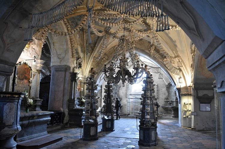
Inside Sedlec Ossuary. (Richard Mortel / Flickr)
Imagine walking into a Church and finding the interior decorated with human skulls and bones. It sounds like something right out of a horror film, but, actually, there is such a church in Kutná Hora in the Czech Republic. It is called the Bone Church, otherwise known as the Sedlec Ossuary. The Roman Catholic chapel contains bones from around 70,000 skeletons and these bones have been decoratively arranged for maximum aesthetic effect.
Is the result macabre? Strangely enough, no. Most visitors remark that the Sedlec Ossuary has a very tranquil atmosphere. It remains a holy place of worship and, even with the displayed human bones, visitors don’t generally appear to experience any feeling of unease.

Sedlec Ossuary. (Ray Schauweker / Flickr)
The Sedlec Ossuary
Sedlec is a suburb of the Czech town Kutná Hora, and it was once the site of the Sedlec Abbey. The Cemetery Church of All Saints was once part of this former Abbey. Underneath this Church is the Roman Catholic chapel that is widely known as the Sedlec Ossuary or the Bone Church. Constructed in a medieval High Gothic style, the Church has a vaulted roof and three towers. When you step into the chapel underneath, you realize what a really unique place it is.
The interior of the chapel is decorated in an artistic way with human bones. The two artworks that will immediately catch your eye are the Chandelier of Bones and the Schwarzenberg family’s Coat of Arms. Both are large and prominent and made entirely of bones. The Chandelier of Bone is supposed to contain every single bone that is present in the human body. This Chandelier hangs in the chapel’s center.

A chandelier made entirely of human bones at Sedlec Ossuary. (Ray Schauweker / Flickr)
How did the bones end up in the church?
In 1142, a Cistercian Monastery was established in Sedlec. The monks that came to reside in this Monastery undertook the work of maintaining and cultivating the lands around the Monastery. In 1278, Bohemia’s King Otakar II asked the Abbot of Sedlec, Henry, to go on a pilgrimage to Jerusalem in Palestine.
When the Abbot returned from his pilgrimage, he brought with him some of the holy earth from Golgotha, the site where Jesus Christ was crucified. The Abbot sprinkled some of this earth all over the cemetery of Sedlec Abbey to consecrate the ground.
As soon as the word of this act got around, people started arriving at the Abbey with their sick, dying, and dead relatives. They wanted them buried in the now consecrated ground. The cemetery of Sedlec Abbey suddenly became Central Europe’s most sought-after burial place.
Two catastrophic events sweeping through Europe – the Black Death of the mid-14th century and the Hussite Wars in the early 15th century – caused the Sedlec Abbey cemetery to receive thousands of bodies for burial and it became necessary to enlarge the cemetery.
According to historical records, at least 30,000 people died in Sedlec from the plague and were buried in the cemetery. Most of the people were buried in mass graves as, given the high death rates at the time and the necessity of disposing of the bodies quickly before they spread the dreaded disease further, it was not possible to dig individual graves for everyone.
Around 10,000 people died and were buried in the Sedlec cemetery during the Hussite Wars. Kutná Hora fell to the Hussite army in 1421, and the Hussites attacked the Sedlec Abbey, plundered the Cistercian Monastery, burned both the Monastery and the Cathedral, and despoiled the cemetery.
The Gothic Church, with an upper vaulted level and a chapel on the lower level, was built around 1400 in the central part of the cemetery. During the construction of this Church, many of the mass graves were disturbed. The bones that were unearthed in the process were collected and stored in the chapel. Later, when old graves were dug up and their contents removed to make way for new burials, the recovered bones were also stored in the chapel.
According to local lore, in the early 16th century, a half-blind monk was put in charge of exhuming bones and arranging them decoratively in the chapel, and, after completing the task, his vision was restored.

The decoration inside Sedlec Ossuary. (Deror_avi / Wikimedia Commons)
The Church of All Saints underwent some major renovation and rebuilding in the early part of the 18th century, with the architect Jan Blažej Santini-Aichel infusing a Baroque Gothic style into the completely rebuilt upper chapel.
In 1783, the Holy Roman Emperor, Joseph II, abolished the Sedlec Monastery. The Schwarzenberg family of Orlikthen bought the property and paid for the continued maintenance of the Sedlec Ossuary. In 1870, the Schwarzenberg family hired FrantišekRint, a woodcarver from Česká Skalice, to rearrange and redecorate the bones in the lower chapel. The great Chandelier of Bones, as well as the Coat of Arms, are both his handiworks. He signed his name on one of the bones and this bone can now be seen by visitors near the chapel’s entrance. No other information about him is available in any historical records.

Coat of arms of Schwarzenberg family. (word_virus / Wikimedia Commons)
Visiting the Sedlec Ossuary
Kutná Hora is some 70 km from the Czech Republic’s capital Prague and about an hour away by train. It is a very small town now, but, in the medieval times, when it had working silver mines, it was well-populated and was considered the region’s second largest city.
From the train station, on your arrival from Prague, you can take a local train to Sedlec. You can also go by local bus, tourist bus, minivan, or taxi. If you walk from Kutná Hora town center, it takes about 45 minutes to reach Sedlec. Given the ready availability of local transport, however, you won’t need to walk all the way unless you absolutely need to.
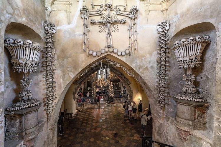
The entrance of Sedlec Ossuary. (Thomas Ledl / Wikimedia Commons)
The Sedlec Ossuary charges a small entry fee and has different opening hours throughout the year. You can visit between 8 a.m. to 6 p.m. from April to September and from 9 a.m. to 5 p.m. October through March. In winter, from November to February, visiting hours are 9 a.m. to 4 p.m. During Christmas, the Sedlec Ossuary remains closed for visitors.
If you want to take back a souvenir of your visit, the gift shop sells several interesting bone-related items, including a plaster human skull.
Enjoyed this article? Also, check out “Church of the Dead: Home to the Peculiar Mummies of Provincial Italy“.
Fact Analysis:
STSTW Media strives to deliver accurate information through careful research. However, things can go wrong. If you find the above article inaccurate or biased, please let us know at [email protected].
RELATED
 June 16, 2019 Church of the Dead: Home to the Peculiar Mummies of Provincial Italy
 March 22, 2019 Sagrada Familia: An Unfinished, Colossal Spanish Basilica, Under Construction for More than 136 Years
 December 30, 2018 Lake Reschen: Italy’s Submerged Lake Reschen
 January 22, 2019 Ämari Pilots’ Cemetery: Where Aircraft Tail Fins Adorn Soviet Pilots’ Tombstones
The post Sedlec Ossuary: The Famous Bone Church of Kutná Hora in the Czech Republic appeared first on .
]]>The post The Cano Cristales: Colombia’s Extraordinary River of Five Colors appeared first on .
]]>
River Cano Cristales. (Pedro Szekely / Flickr)
The Cano Cristales river is one of Colombia’s most spectacular natural wonders. Running for 100 kms through the Serranía de la Macarena National Park in Colombia, this incredible five-coloured river has its source to the south of the park and flows eastward to become a tributary of the Guayabero river. The colours of the rivers come from the Macarenia clavigera river weed that grows underneath the fast-flowing river water.
The three different ecosystems of the Andes mountain range, the East Llanos savannah, and the Amazon rainforest meet at the Serranía de la Macarena, making it one of the most biodiverse areas in Colombia. The Serranía de la Macarena includes over 500 species of birds, 1,200 species of insects, 100 species of reptiles, and over 2,000 species of plants. To protect this biodiversity, the Colombian government designated 6,200 square kilometres of the area as a national park in 1971.
The Cano Cristales river
In Colombia, the local populace refers to small rivers as pipes. With a width of 65 feet, the Cano Cristales river is a pipe. The water in the river is so pure and transparent that you can clearly see right down to the rocky riverbed. Along its length, you will encounter several waterfalls, deep pools, and caverns. The caverns are a result of centuries worth of steady erosion as the fast-flowing river water sped past the rocky faces.

Cano Cristales, Colombia. (Mario Carvajal / Wikimedia Commons)
The pools formed as a result of the enlargement of small pits in the rock bed. This enlargement came about from rock pieces grinding against the pit’s wall as the water current swirled the rocks around. The river water lacks the nutrients necessary to sustain aquatic wildlife, so there are no fish in the Cano Cristales. The colourful Macarenia clavigera is the only plant life in the river.
Macarenia clavigera
Macarenia clavigera is a river weed from the botanical plant family Podostemaceae. Native to subtropical and tropical climates, these river weeds grow underwater, clinging tightly to hard rock and stone beds in fast flowing rivers. Macarenia clavigera is known to exist only in Colombian rivers such as Cano Cristales and Cano Siete Machos in Meta department, and Cano Tranquilandia in Guaviare department.
The plant is rather fragile, with a thick, flexible stem that has thin, delicate, and cotton-thread-like leaves. It comes in various colours, the colour depends upon the amount of sunlight the plant is exposed to and the depth of water in which it is growing. In areas where there is a lot of sunlight, the plant can be seen in colours like pale pink, magenta, various shades of red, and deep purple. In shaded areas, the plant usually looks bright green and can appear to be blue, yellow, or orange coloured as well.

Macarenia clavigera river weed. (Peter Fitzgerald / Wikimedia Commons)
The geographic characteristics of Colombia such as its closeness to the equator and its wide range of altitudes ensure variable weather experience at different locations of the country throughout the year.
The rainy or wet season occurs in the months of April, May, October, and November. During this season, when water levels are high and hardly any sunlight reaches the depths of the river bed, the Macarenia clavigera is olive-coloured and is difficult to see in the water. In the dry and hot summer months of December, January, July, and August, the plant lacks the water it needs to colourfully thrive. It sheds its seeds in this season. New plants start to sprout in the following wet season, with the growing roots deriving nutrients from the minerals in the rocks in the riverbed.
From the beginning of August to the end of October, Macarenia clavigera finds the ideal amount of sunlight and water it needs to bloom in abundance, and it then colours the Cano Cristales with its vibrant hues. This picture changes practically every year, as the swift water current moves and alters the positions of river rocks to some extent and the river carves new paths through the rocks. Old trees fall in some areas and new trees proliferate thickly in other areas, creating new sunny and shady areas along the river. These changes affect the growth of the Macarenia clavigera and that, of course, affects the colours of the river.
Discovery of the Cano Cristales river
The indigenous people living in the area have known the Cano Cristales for centuries. The rest of world got to know of its existence only in 1969 when some Colombian cattle farmers went to explore the area and came across the river when Macarenia clavigera was in bloom. The discovery, however, did not lead to an influx of tourists trekking through the wilderness.
For many years, from 1964 to 2002, the war between the Colombian government and the FARC guerrilla armies made the area inaccessible to the general public. In the mid-2000s, the government was able to regain control of La Macarena and around 30 km of its surrounding area. While the government could not guarantee the safety of visitors beyond this area, the strong Colombian military presence in La Macarena made it relatively safe for adventurous tourists to visit the Cano Cristales river. The area became a popular tourist destination after air travel became possible in 2009. In 2017, the FARC disarmed themselves and the area has been at peace since then. There are now many hotels and restaurants in the area.
Environmental protection of the Cano Cristales river
A regional government agency called Cormacarena manages sustainable development in the area. Various communities residing in the area also take an active part in ensuring that the environment is not harmed. To protect the Macarenia clavigera plants and the river from pollution, the Columbian government has enacted and enforced several environmental laws.
They have made it mandatory for tourists to apply for a permit from the National Parks Office prior to visiting the Cano Cristales river, and they allow only 200 tourists to visit the area per day. Tourists must only visit in groups of up to seven people, and they have to be accompanied by an authorized guide. There is a ban on the use of sunscreen lotions and insect repellent sprays in the area. Swimming is limited to some designated areas of the river. From January to June, the authorities do not allow visits to the Cano Cristales river to ensure that the Macarenia clavigera plants can propagate undisturbed in these months.

Macarenia clavigera in Caño Cristales. (Pedro Szekely / Flickr)
Visiting the Cano Cristales river
As the photogenic Macarenia clavigera attracts more tourists, the Cano Cristales river is becoming popular as an ecotourism destination.
If you would like to visit the Cano Cristales river, you should head for La Macarena, a small town on the banks of the Guayabero River, right next to the National Park. There are direct flights from Bogotá, Villavicencio, and Medellín to La Macarena. From La Macarena, there are jeeps and boats to take tourists to the start of the hiking trails in the national park which lead to Cano Cristales. Tourists have to travel back to La Macarena in the evening; it is not possible to stay overnight as there are no campsites.
Enjoyed this article? Also, check out “Tsingy de Bemaraha National Park: Natural Beauty of Stone Forest in Madagascar“.
Fact Analysis:
STSTW Media strives to deliver accurate information through careful research. However, things can go wrong. If you find the above article inaccurate or biased, please let us know at [email protected]
RELATED
 August 28, 2019 Hoatzin Reptile Bird: A Dinosaur-Like Bird with the Digestive System of a Cow
 June 25, 2018 Tsingy de Bemaraha National Park: Natural Beauty of Stone Forest in Madagascar
 December 1, 2018 Mapogo Lions: The Six Legendary Lions That Meant ‘Bloody’ Business in Their Quest for Dominance
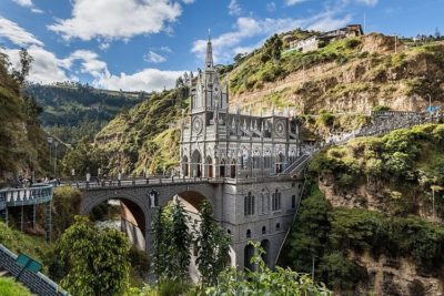 July 28, 2018 Las Lajas Sanctuary: A Church with a Mysterious Mural Nobody Can Explain
The post The Cano Cristales: Colombia’s Extraordinary River of Five Colors appeared first on .
]]>The post Monowi, Nebraska: A Village in Boyd County, United States with a Population of One appeared first on .
]]>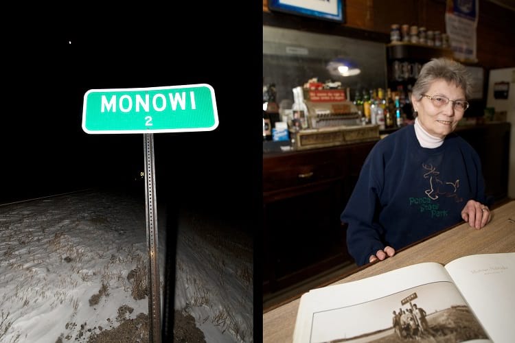
Monowi sign (right) and Elsie Eiler the mayor of the village (right). (marco antonio torres / Flickr)
Imagine living in a village in which you are the sole inhabitant. That makes you the soul of your community. The life of the neighbourhood. You don’t have anyone to talk to, but that’s okay. You don’t have the time to be lonely, considering that you’re running everything in the village yourself.
While that may sound like a tall tale, there is actually such a person and such a village on this planet. To be precise, the village is in the US state of Nebraska and is called Monowi. It has a population of one.
Monowi, Nebraska
According to the 2010 census, Monowi village has the distinction of being the only incorporated municipality in the country to have only one resident. There are other places in the US where there is a population of one – PhinDeli Town Buford in Wyoming and Hibberts Gore in Maine – but they are unincorporated. In recent years, a population of one have been recorded in Rochefourchat in France, Jordan River in Canada, Villa Epecuen in Argentina, Tomioka in Japan, and Cass in New Zealand.
History of Monowi
Monowi is located between the Niobrara and Missouri rivers and occupies 0.54 square kilometres of land. In 1902, when the Fremont, Elkhorn, and Missouri Valley Railroad was being built through the area, the Pioneer Townsite Company drew up plans for a village and named it Monowi. The name came from the prairie flowers growing at the site which were called ‘monowi’ in the local Indian language.
In the 1930s, the village’s population count was 123, and this was its highest ever. It wasn’t to last. The main issue with Monowi was that the area was not very conducive to farming, and most of the folks who settled there wanted to attempt farming. Despite their determination and hard work, there wasn’t much they could do about the poor soil condition. Over the decades, finding farming too difficult of an endeavour, many of the residents began to migrate elsewhere in search of employment.
The 1955 census listed 99 residents in the village, and, by 1980, the population had dwindled to 18. As fewer people visited the village and traffic diminished, the railway authorities discontinued the railway to Monowi. Soon, the post office closed as well. Realizing that the village had no future, more residents moved away.
The village now has dozens of abandoned buildings, and the prairie is slowly reclaiming the land. The population census of 2000 recorded the population count of two, a married couple, Rudy and Elsie Eiler.

Monowi, Nebraska. (Bkell / Wikimedia Commons)
Elsie Eiler, a citizen of Monowi
Ever since her husband Rudy passed away in 2004, Elsie has been the only person living in Monowi. Some of her grown children live in nearby cities and visit her often.
Being a single citizen of Monowi, Elsie stays busy. She established a small library in memory of her husband and named it Rudy’s Library. Elsie acts as the librarian, taking care of around 5000 books which were part of Rudy’s private collection. Anyone wishing to borrow books and magazines to read can do so, or they can just browse through the library.

Rudy’s Library. (Bkell / Wikimedia Commons)
She is the proprietor and the bartender of the Monowi Tavern, which she and her husband opened in 1975 after they decided to settle in Monowi. She is, of course, the only full-time staff at the bar, serving burgers, hot dogs, salads, fries, steak, and the coldest beer in Monowi. The tavern is open to visitors all days of the week from 9 a.m. onwards, except on Mondays when Elsie takes the day off.
Occasionally, her children help her out, and she hires other staff when there are large gatherings planned at the tavern. Most days she enjoys spending time with the regular customers from neighbouring towns who consider the tavern a meeting place to talk about life and families and play card games. People passing through the village on their way to other towns often stop here for food and drinks.
As the only candidate and the only voter, Elsie gets elected as the Mayor of Monowi when such elections are held. After becoming the Mayor, she grants herself a liquor license to run the bar, pays taxes to herself, and, every year, produces a municipal road plan to get state funding to maintain the village’s four street lights and water supply. As there is no municipal staff in the village to provide services, Elsie relies on the kind and helpful farming community around Monowi for assistance, such as clearing snow from the street. Also, whenever she needs some help, anybody who is visiting the tavern lends her a hand.

Elsie Eiler in her bar restaurant Monowi Tavern. (marco antonio torres / Flickr)
Numerous TV shows, newspapers, and magazines have featured Elsie and Monowi for their unique status. That has brought them fame and curious visitors from all over the USA and from over 40 countries. After the host of a radio show announced that he was going to raise money for Elsie’s village by holding a hotdog roast event, over a thousand people turned up. The summer months attract some tourists to Monowi, even though the village is rather out of the way.

Monowi. (Andrew Filer / Flickr)
The future of Monowi
Quite a few people feel that places such as Monowi should be preserved. It is, however, an entirely different proposition to convince them to come and settle in the village. All over the Great Plains, which include Nebraska, the collapse of rural economies has led to the depopulation of the countryside over the past five decades. To remain in existence, many towns have come up with schemes like forming artist colonies and building business parks. Some have succeeded and some have failed.
For now, the 84-year-old Elsie Eiler continues to enjoy living alone in Monowi.
Enjoyed this article? Also, check out “Cassadaga in Florida: Home to the Largest Psychic Community in the World“.
Fact Analysis:
STSTW Media strives to deliver accurate information through careful research. However, things can go wrong. If you find the above article inaccurate or biased, please let us know at [email protected].
RELATED
 September 30, 2018 Codex Gigas: The Dark Medieval Manuscript Dubbed as “The Devil’s Bible”
 June 18, 2019 Bingham Canyon Mine: The Largest Copper Producing Mine in the United States
 July 15, 2019 Adalaj Stepwell: A 500-Year-Old Architectural Masterpiece With a Tragic Tale of Unrequited Love, Sacrifice And Loss
- May 31, 2019 Chand Baori: A Quaint Remnant of the Past
The post Monowi, Nebraska: A Village in Boyd County, United States with a Population of One appeared first on .
]]>The post The Moeraki Boulders of New Zealand: Naturally Formed Spherical Boulders from the Paleocene Era appeared first on .
]]>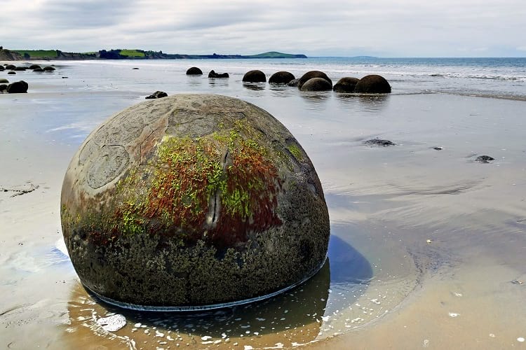
Moeraki Boulders at Koekohe Beach, New Zealand. (Bernard Spragg. NZ / Flickr)
If you visit Koekohe Beach on the Otago Coast on the South Island in New Zealand, you will encounter enormous round boulders known as the Moeraki Boulders. They dot the landscape both in clusters and as single standing stones. Some of the boulders have tortoise shell type markings on them while others have split open to reveal hollow and sometimes colourful cores.
While these balls look like an alien might have spilled them across the landscape, they actually emerged from the mudstone cliffs due to erosion brought about by wind and wave action. As the cliffs continue to erode, we will find more Moeraki Boulders on Koekohe Beach.

Moeraki Boulders. (Krzysztof Golik / Wikimedia Commons)
Moeraki Boulders’ formation
According to researchers, it is likely that the Moeraki Boulders first formed from the seafloor mud over 56 million years ago in the Paleocene era.
The grey-coloured Moeraki Boulders are concretions. That is, their formation process came about from by layers upon layers of sediments depositing over one another and then cementing together with minerals. Over time, with the continued addition of cemented layers, the boulders grew to be very large in size. It took many million years for the large boulders to take shape, and the formation of a Moeraki Boulder was not dissimilar to the formation of a pearl in an oyster shell. As in the case of a pearl, the sediment layers began to form around an organic particle.
While at first sight, all the Moeraki boulders appear spherical, they are not all perfectly round. Some of the boulders have more ovoid shapes. In their sizes, the boulders vary considerably. You will come across some boulders that range in diameter from 1.6 feet to 3.3 feet while others have diameters of 4.9 feet to 7.2 feet.

A large Moeraki Boulder. (karlnorling / Flickr)
Researchers are not exactly sure how the spherical forms came about but offer different theories. According to one theory, the continuous effect of the waves against the rocks may have worn down and smoothed and rounded the rock surfaces. Another theory suggests that, during the boulder formation, the boulder received liquid mineral content in equal amounts from all directions around the core and this led to the spherical form of the boulder.
Some of the boulders have distinct cracks in them while some have broken open to reveal their hollow interiors. Researchers call the cracks in the boulders as septaria and they think that these septaria occurred shortly after the formation of the concretions. Of course, nobody knows exactly why these cracks happened, but there are different theories as to their cause. Perhaps they formed as a result of earthquakes, or because the concretion dried too fast. It may have been because the inner organic cores shrank and released gases that expanded and put pressure on the concretions, leading to the septaria.
In the boulders that have cracked open, researchers found that the inner hollow cores are weak compared to the very hard outer layers.

A cracked Moeraki Boulder. (Krzysztof Golik / Wikimedia Commons)
Maori legend about the Moeraki Boulders
If the scientific theories for the formation of the Moeraki Boulders seem somewhat mundane to you, the Maoris have a more colourful explanation.
According to Maori lore, the KähuiTipuatribe once decided to set out across the ocean to find Hawaiiki, a mythical land famous for its Kumara sweet potatoes. The KähuiTipua people wanted to bring back the sweet potato plants to grow them on their own land. So, they set off in the Arai TeUru, their double-walled waka; in the Maori language, waka means canoe.
On the way back, a fearsome storm overtook them, and the Arai Te Uru ended up wrecking itself at Shag Point just off the Otago Coast. Everything in the waka fell overboard and later, as the storm abated, some of this found its way ashore to Koekohe Beach. The eel baskets, water calabashes, and sweet potato kumaras ended up on the beach and became transferred into the Moeraki Boulders. The wreck of the waka, in turn, became a reef; you can see it if you visit the mouth of the Waihemo River.
Other colourful tales about the Moeraki Boulders
You’ve probably heard this one for other strange natural occurrences – it was the Aliens. According to some tall tale tellers, the Moeraki Boulders are the unhatched eggs that the Alien parents had to leave behind after an unsuccessful attempt to colonize the Earth. Other tall tale tellers claim that the boulders are unhatched dinosaur eggs and, if not that, then dinosaur poop, both solidified with layers and layers of sediments.
The western discovery of the Moeraki Boulders
Westerners discovered the Moeraki Boulders in the 1800s. A scientist and politician named Walter Mantell made a drawing of the beach strewn with the boulders in 1848. In this drawing, which you can now see in Wellington’s Turnbull Library, the boulders appear far more numerous than there are at present. This may be on account of the cracking of some of the boulders. The boulders, otherwise, are pretty tough and have managed to weather climatic conditions very well.
Visiting the Moeraki Boulders
Take State Highway 1 from Christchurch to Dunedin. The Koekohe Beach is in the South Island’s Otago region, about a one-hour drive from Dunedin, between the towns of Moeraki and Hampden. You can also drive over from Oamaru, which takes around 30 minutes, or from Cromwell, which takes a couple of hours. Leave your car at the car park at the Moeraki Boulders Scenic Reserve and walk to the beach.
There is no charge to visit the beach to see the Moeraki Boulders, but, note that, if you have the super strength to carry any of them away, you cannot legally do so. Previously, people often carried off the smaller boulders for garden decoration and other purposes. The area is now a protected sanctuary for boulders. You can clamber around them, but you can’t take them home.
If you are a photography enthusiast, you can have a grand time photographing the boulders. They offer some great photo opportunities, especially in the early morning hours and in the late afternoon. They also look great in stormy weather when the dark clouds are rolling overhead. It’s best to visit during low tide when you see all the boulders clearly and can walk up to them. If you go during high tide, you will see only some of their top portions. The MetService page can help you time your visit.
There are some nice accommodation options in Hamden and Moeraki if you want to stay in the area and explore the boulders and the beach some more.
Enjoyed this article? Also, check out “Penitentes – The Remarkable Ice Pillars of the Atacama Desert“.
Fact Analysis:
STSTW Media strives to deliver accurate information through careful research. However, things can go wrong. If you find the above article inaccurate or biased, please let us know at [email protected].
RELATED
 April 12, 2019 The Wave in Arizona: A Geological Wonder
- March 2, 2019 Wave Rock: Where a Massive Prehistoric Wave, Just About to Break, is Etched Permanently in Stone
- April 14, 2019 Fingal’s Cave: The Musical Geometry of Nature’s Domain
- August 31, 2020 Ennedi Plateau and Aloba Arch: Home to Exquisite Natural Formations and ‘Extinct’ Animals
The post The Moeraki Boulders of New Zealand: Naturally Formed Spherical Boulders from the Paleocene Era appeared first on .
]]>The post Kármán Line: The Hypothetical Line That Delineates the Earth’s Atmosphere from Outer Space appeared first on .
]]>
Photo of earth from International Space Station. (NASA / ISS043-E-86375)
The Kármán line is a hypothetical boundary located 100 km above sea level, designating the end of the earth’s atmosphere and the beginning of outer space. It is named after the Hungarian scientist Theodore von Kármán. He suggested its creation for the clear-cut separation of the fields of aeronautics and astronautics.

Theodore von Karman. (Theodore von Karman / Flickr)
Understanding the Earth’s atmosphere
The earth’s atmosphere is what we commonly call air, a dense mixture of gases whose physical properties affect everything moving within it. As you move up from the earth’s surface, the density of the air progressively decreases to eventually meld into the vacuum of outer space. There is no definite boundary where this happens. Experts estimate the distance to be between 100,000 km and 190,000 km above the earth’s surface. This area is the last layer of the atmosphere and is called the exosphere. The layer below this is called the thermosphere, which is between 500 km and 1,000 km above the earth’s surface. The mesosphere extends from a height of 50 km to 85 km; the air here is too thin to breathe. The stratosphere extends from 10 km to 50 km above the ground. The lowest layer with a height of about 10 km is called the troposphere. We live in this layer and the formation of clouds occurs here. Scientists defined the boundaries of these spheres at the points where there are discernible changes in the temperature of the air.
Satellites in the Earth’s atmosphere
Satellites orbit the earth at distances ranging from 160 km to 36,000 km above the earth’s surface. The International Space Station orbits at around 400 km. The Hubble Space Telescope orbits at 569 km. All these distances are within the earth’s atmosphere, but we talk about them orbiting in space as the atmospheric conditions at those distances have a negligible effect on their operation. So, the vehicles used to travel to the International Space Station and to repair satellites are called spacecraft and the people travelling in these vehicles are called astronauts.

Hubble Space Telescope. (NASA Hubble Space Telescope / Flickr)
Airplanes flying in the Earth’s atmosphere
An aircraft moves relative to the air and that movement is what enables its wings to generate the lift necessary to keep it flying forward. Passenger jets usually fly in the lower part of the stratosphere as the airflows there are less turbulent than in the troposphere. If they fly higher up into the mesosphere, they have to increase their speed to generate the necessary wing lift in the thinning air. Above the mesosphere, there is not enough air to provide any lift to an aircraft’s wings and it is pulled downwards by gravity. To stay aloft, the aircraft would have to increase its speed to touch orbital speed and then would have to follow the earth’s curvature.
The Kármán line
So, the highest distance above the earth’s surface where there is enough air for an aircraft to get the wing lift to fly in a straight line is considered by some people to be the end of the atmosphere.
Theodore von Kármán calculated this distance to be around 83 km and suggested that the value be rounded up to 100 km to make it easier to remember. The Fédération Aéronautique Internationale (FAI), the governing body for air sports, maintains separate records for air sports and space flights. It uses the Kármán line to differentiate between the two. However, not all countries and organizations are in unanimous agreement on the location of the Kármán line. Some countries consider the distance to be 50 km above the earth’s surface and other countries consider the distance to be 80 km.
The importance of the Kármán Line
Just as a country’s territorial rights extends for about 22 km in the surrounding seas and oceans, beyond which distance oceans are considered international waters, a country’s territorial rights also extend upward into the atmosphere. Hence, it is necessary to have something like the Kármán line to delineate airspace governed by each country from outer space over which no country can claim sovereignty. All countries have rules and regulations for passenger aircraft flying in their airspace.
Private space exploration companies, who are developing passenger spacecrafts, would have to know the distance above which they can fly to avoid this jurisdictional area. Another issue is whether these passengers can call themselves astronauts. There are countries that are opposed to defining a boundary for military reasons, and there are some countries that want a definite boundary for the same reason. Fighter aircrafts and missiles, which can travel higher than passenger aircrafts, could fly through sovereign airspaces, provoking military aggression.
There are satellites in low elliptical orbits whose distance from earth varies, based on their position. The closest distance is called perigee, and, for some satellites, this distance is below 100 km. Are the satellites sometimes orbiting in space and sometimes in the atmosphere?
National space institutions as well as private research institutions launch satellites for various purposes. What are the laws that should be applied if there are any disputes over the use of satellites while passing through national airspace?
There are some international rules and regulations for operating in what is considered outer space, and, so far, there have been no problems because of the lack of a definite boundary where this outer space begins. But that does not preclude issues from arising in the future as there is an increase in space exploration and space utilization activities.
Enjoyed this article? Also, check out “The Wallace Line: The Invisible Line of Bio-Diversity in the Indian Ocean“.
Fact Analysis:
STSTW Media strives to deliver accurate information through careful research. However, things can go wrong. If you find the above article inaccurate or biased, please let us know at [email protected].
RELATED
 January 14, 2019 The Soyuz 11 Tragedy – The Death of Three Soviet Cosmonauts in Space
- February 26, 2019 Skylab: The Space Station that Failed in Spite of Brilliant Conception and Brave Execution
 July 3, 2018 Space Burial: Making Skies Our Cemetery
 November 2, 2018 HP Enterprise Creates History as Cloud Computing Experience Reaches Space
The post Kármán Line: The Hypothetical Line That Delineates the Earth’s Atmosphere from Outer Space appeared first on .
]]>The post Hochosterwitz Castle: The Medieval Castle in Austria That Remained Impregnable from Enemy Attacks appeared first on .
]]>
Aerial photo of Hochosterwitz Castle. (Arcomonte26 / Wikimedia Commons)
While there is no dearth of spectacular castles in Austria, Hochosterwitz Castle is perhaps one of the most outstanding strongholds from the Medieval Age. It is at an altitude of 2,178 feet above sea-level in the Austrian province of Carinthia and perched on top of a 564-feet high Dolomite rock, with the route to the castle curving around the rock. On clear days, you can see it from nearly 30 km away. From the castle itself, you have expansive views of the glorious countryside.
History of Hochosterwitz Castle
The Dolomite rock on which Hochosterwitz Castle sits has had human settlements since the Bronze Age. We first hear of the Castle in 860 A.D. when Louis the German, King of East Francia, mentions Asterwiza as one of his properties in a deed that listed the properties he was donating to the Archdiocese of Salzburg.
In the 11th century, Archbishop Gebhard of Salzburg gave the castle to the Sponheim family in return for their political support in the Investiture Controversy. This was a long-lasting power struggle between Henry IV, the Holy Roman Emperor, and Pope Gregory VII, each insisting they had more God-given right than the other to select and appoint the clergy.
At the time, the higher ranks of the clergy came from aristocratic families; the first-born son inherited the family title and of the remaining sons, those that didn’t go into the military, took ecclesiastical vows. Since the upper clergy had control over vast swathes of land and received enormous sums of money from the population, this was a very lucrative profession. By appointing the clergy, the King or the Pope could control the properties that came to them and thus exert more influence and gain more power.
By 1122, the Sponheims grew more powerful and when one of their own, Henry IV, became the Duke of Carinthia, they broke away from Salzburg. At this time, they gave Hochosterwitz Castle to the Osterwitz family and conferred on them the honour of being the hereditary cup-bearers of the Duke of Carinthia.
Hochosterwitz Castle remained with the Osterwitz family until 30 May 1478 when the last of the family, Hans Schenk von Osterwitz, before his death, repaid his debts to the Habsburg Emperor Frederick III by handing over the family castle, lock, stock, and barrel.
In 1541, the German Habsburg Emperor Ferdinand I presented Hochosterwitz Castle to Christof Khevenhüller, the Governor of the Carinthian province. Christof Khevenhüller apparently had no interest in maintaining the Castle himself and gave the lieu to his cousin Baron George Khevenhüller.

Hochosterwitz Castle from a different angle. (Johann Jaritz / Wikimedia Commons)
An impregnable fortress
To reach Hochosterwitz Castle, you must pass through 14 gated entrances before you can step foot on its grounds. Baron George Khevenhüller, the Castle’s aristocratic owner, devised these defences between 1571 and 1600 to protect the Castle from Turkish incursions, and they proved to be massively successful. The enemy was never able to get past the fourth Engelstorgate and the Castle remained impregnable.

Hochosterwitz Castle. (Rollroboter / Wikimedia Commons)
At another time, much before the time of our Baron, before the 14 gates existed, the Castle was still able to stave off enemies. It survived a famous siege by Margarethe Maultasch of Tyrol, but, of that, it is debatable whether the Castle survived on its own merit or on account of Margarethe’s gullibility.
The defenders, who were nearly down and out from starvation, summoned up their last bit of strength to butcher their last remaining ox, pull out its innards, and stuff its belly with their last remaining stock of corn. They then slung the carcass on their last remaining projectile machine and hurled it towards Margarethe and her enemy.
Margarethe ducked the dead ox and then over thought the matter.
“If they can throw oxen and corn at us,” she thought, “they must have plenty of supplies to last them a good long while. That means, we’ll be here forever if we continue with the siege.”
Since she couldn’t afford to continue the siege indefinitely, she took her army and withdrew.
Of course, we don’t know for sure if it was really the ox that made her withdraw, but it’s a good story and bears repeating.
Baron George Khevenhüller
The Baron was a man of vision and saw enormous potential in Castle Hochosterwitz. Not wanting it to be a Royal bequeath but his own personal property, he paid the Habsburg Emperor a good amount of money for its outright purchase in 1571.
Then, using his own money, he proceeded to fortify the Castle in every way possible. The 14 gates mentioned earlier were each equipped with different and deadly methods of tackling the oncoming enemy. If you didn’t get boulders dropped on you, there might be an outpouring of boiling oil in the offing. Or archers waiting around the next bend, ready to unleash their arrows at you. The Turks got a taste of it and retreated in haste.
Baron George Khevenhüller continued fortifying the Castle throughout his life and lived pretty much in peace and contentment there with his two wives and their offspring. In his will, he warned his descendants to never take the Castle’s security lightly. They clearly heeded his advice and never let the Castle slip from their grasp. It remains in the Khevenhüller family’s possession to this day.
They open certain sections of it for a fee to the public during the summer and get thousands of visitors. It is certainly good to have an astute ancestor whose wisdom is still paying off centuries later. If you happen to visit, check out the great collection of medieval weapons and armours.
When you see these, you realize how fearsome people used to be back in the old days. Not that human nature has changed drastically in the present age, but, probably, very few people would have the gumption to go into battle in creaking iron suits while dodging wild swings from sharp swords and spears.
Enjoyed this article? Also, check out “Neuschwanstein Castle: The Story Behind the Iconic Bavarian Castle That Inspired the Disney Castle“.
Fact Analysis:
STSTW Media strives to deliver accurate information through careful research. However, things can go wrong. If you find the above article inaccurate or biased, please let us know at [email protected].
RELATED
 July 26, 2019 The Rock of Gibraltar: Guardians of the Strait of Gibraltar
 April 27, 2019 Neuschwanstein Castle: The Story Behind the Iconic Bavarian Castle That Inspired the Disney Castle
 August 29, 2018 1999: Jeanne Menjoulet’s Journey to the Dunes of Dasht-e Kavir
 June 5, 2020 The Deadly Garden with Over a Hundred Different Varieties of Toxic Plants—The Poison Garden
The post Hochosterwitz Castle: The Medieval Castle in Austria That Remained Impregnable from Enemy Attacks appeared first on .
]]>The post Barra Airport, Scotland: Where Planes Take Off and Land on a Beach appeared first on .
]]>
Barra Airport, Scotland. (© Stephen J Mason / Flickr)
Ever thought of taking off from and landing on a long stretch of white sand, with ocean waves lapping at the beach edges? If you are ready for a great flying adventure, you should head for Barra Airport in Scotland. It is the only airport in the world where the runway is a beach.
Barra Airport in Scotland
It is located in Barra, an island of the Outer Hebrides off the west coast of Scotland. At the northern end of Barra, where the village of Ardmhor extends to the village of Eoligarry, there is a magnificent white beach made up of hard compacted shell sand. The beach is called Traigh Mhor which, in the Gaelic language, means Big Beach.
At the beginning of the 1930s, when the authorities were considering building an airport on the island of Barra, the local postmaster, John MacPherson, suggested that the beach would be suitable to be used as a runway. His suggestion was taken up and aircraft began using the beach in June of 1933. It wasn’t until August of 1936 that the airport, also known as Barra Eoligarry Airport, was officially opened for scheduled air services.
The Highlands and Islands Airports Limited, which owns and operates most of the regional airports in Scotland, manages Barra Airport. The airport is licensed to allow passenger flights and pilot training flights. With its beautiful, scenic location, the airport has regularly featured in various polls as one of the top 10 airports in the world.
The world’s most scenic airport
Barra airport offers a unique experience, with passengers boarding and disembarking from the aircraft on the beach. The airport staff loads and unloads the passenger luggage at the same time. The well-equipped airport has a nice terminal building. The café in the terminal is popular for its local seafood, soups, home-baked food, and great coffee.

Barra Airport terminal. (Neil King / geograph.org.uk)

Inside the terminal of Barra Airport in 2010. (© Stephen J Mason / Flickr)
You can get some spectacular views from the air traffic control tower. To the east, you can see the island of Orasaigh and, further away, the islands of Fuday and Eriskay. At the back side, to the west, you can see the high sand dunes on the beach of Traigh Eais and the waves of the Atlantic rolling onto the beach.
There is a strobe light on the air traffic control tower that is turned on to indicate that an aircraft will be arriving soon. The airport is well-prepared to handle all sorts of emergencies, but, so far, there hasn’t been any need for the emergency services at the airport. The dolphins and seals in the Atlantic Ocean are actually more in need of the airport’s emergency services. They frequently get stranded on the Traigh Mhor beach, and require the assistance of the airport’s fire crew to get steered back into the ocean.

Barra Airport air traffic control tower. (© Stephen J Mason / Flickr)
The airport does not have a license to operate at night, but it can be used at night in case of emergencies. The Scottish Ambulance Service operates helicopters which are easier to land on the beach even at night. During night landings, the airport authorities place reflective strips on the beach to demarcate the runway and the area is illuminated with the headlights of vehicles.
Air service at Barra Airport
Loganair, a Scottish regional airline operates De Havilland Twin Otters aircraft to provide air service to Barra from the seaport of Glasgow, 226 km away, and from the island of Benbecula, which is close to 55 km from Barra. The beach is large enough to accommodate the comparatively short take-off and landing runs of the Twin Otters.
The three runways on the beach are laid out in a triangle, taking the prevailing wind directions into account. It is advantageous for aircraft to land and take-off into the wind as this reduces aircraft roll, and also reduces the ground speed required to attain flying speed. The runways are set in 07/25, 11/29, and 15/33 directions to ensure that all landings and take-offs can be made into the wind.

An aircraft at the Barra Airport runway. (© Stephen J Mason / Flickr)
The first runway is 2621 feet long, the second one is 2231 feet, and the third one is 2776 feet long. Wooden poles mark the ends of the runways, and these poles are strong enough to withstand the force of the tides twice a day. Flight timings are dependent on the tides; the runways are operational only when the tides are out. At high tide, the runways are completely underwater.

Sign at Barra Airport to keep off the beach when the airport is active. (Tom P / Flickr)
Traigh Mhor beach
The sandy and sheltered beach of Traigh Mhor is famous for cockles; these are bivalve molluscs are a local delicacy and people eat them raw or cook them with salt, vinegar, garlic, or wine. Thanks to the presence of these molluscs, the beach is also known as The Cockle Strand. People come here to collect cockles, and also on account of its beautiful natural environ. It is popular with locals and tourists alike. A tour of Barra is not complete without a stopover to see the aeroplanes landing and taking off from the beach. When they come to the beach, however, you should check the windsock. If the windsock is flying, the airport is in operation and you should stay away from that area of the beach for your own safety.
Traigh Mhor is also a popular filming location for many film production companies. The stunningly white beach runways make a beautiful picture against the backdrop of the vivid blue of the Atlantic Ocean. Also, the aircraft landing and taking off from such a beach is a grand and dramatic sight that is a film-maker’s delight.
Barra’s beaches attract more and more people every year. Over 10,000 passengers now avail of the airport. There are over 700 passenger aircraft flying in and out of Barra airport, and there are also around 60 private aircraft that use the beach runways every year. The airport has boosted tourism, a major source of income for the residents, and has made providing emergency medicare easier. Once thought of as a luxury, Barra airport is now a valuable facility for the local community on the island.
Enjoyed this article? Also, check out “Reynisfjara: The Black Sand Beach that Looks Straight out of a Gothic Novel“.
Fact Analysis:
STSTW Media strives to deliver accurate information through careful research. However, things can go wrong. If you find the above article inaccurate or biased, please let us know at [email protected].
RELATED
 May 19, 2019 Tavira Island in Portugal and the Anchor Graveyard That is a Memorial for a Lost Way of Life
- August 20, 2019 Reynisfjara: The Black Sand Beach that Looks Straight out of a Gothic Novel
 November 16, 2018 Water Wives of India: Denganmal in Maharashtra, Where Men Have Multiple Wives to Fetch Water
 January 31, 2019 The Lonely House on Ellidaey Island, Where Nobody is Sure of its Residents
The post Barra Airport, Scotland: Where Planes Take Off and Land on a Beach appeared first on .
]]>The post The Silky Anteater: The Nocturnal Dweller of the Tropical Rainforests appeared first on .
]]>
Silky anteater. (Quinten Questel / Wikimedia Commons)
If you ever visit the tropical rainforests of Central and South America or Trinidad, you may want to scan the canopy of the towering trees and try to spot a silky anteater. The chances are high that you won’t see one, certainly not during the day. You might get lucky at night-time though and see one of them clambering from branch to branch in search of food. Silky anteater are nocturnal creatures, and they also prefer travelling across the tree canopies rather than descending to walk on the ground.
In 1758, the Swedish naturalist, Carolus Linnaeus, gave the silky anteater its Latin name, Cyclopes didactylus. The translation is circular feet with two toes. The silky anteater clings to branches by circling its limbs around them. It also has two large and sharp claws on each of its forepaws.

The giant anteater. (Fernando Flores / Flickr)
The silky anteater belongs to the Vermilingua suborder. This suborder includes other anteaters such as the Giant Anteater (Myrmecophagatridactyla), the Northern Tamandua (Tamandua Mexicana), and the Southern Tamandua (Tamandua tetradactyla). Vermilingua, incidentally, means worm tongue in Latin and refers to the anteater’s long, narrow, and sticky tongue that it uses to gather up ants. As you might have guessed from the name, these are the anteater’s main food.
Species of the silky anteater
In 2017, scientists carried out mitochondrial and DNA review of 287 Cyclopes specimens and concluded that, in addition to four existing species, the genus consists of three new species. The existing Cyclopes species are Cyclopes didactylus, Cyclopes ida, Cyclopes catellus, and Cyclopes dorsalis. The three new species are Cyclopesthomasi, Cyclopes rufus, and Cyclopes xinguensis.
Habitat of the silky anteater
You will find the silky anteater in the tropical rainforests of Central and South America. Their habitat ranges from Oaxaca and Veracruz in southern Mexico to Brazil, Peru, Panama, Bolivia, and Ecuador. Silky anteaters with golden pelts occur on the north side of the Andes, while the darker silky Anteaters reside on the south side.
The silky anteater also lives in Trinidad, and the local people call it ‘Poor Me One.’ Apparently, the locals mistook a forlorn bird cry to be that of the silky anteater and assumed it was bemoaning its lonely status. The silky anteater is a rather silent creature in general. However, it is capable of uttering high-pitched and shrill shrieks in adverse situations.
The silky anteater is a protected species, but researchers don’t consider it endangered. Its environment, however, is under threat from human activities.
Physical characteristics of the silky anteater
Also known as the Pygmy Anteater, the silky anteater has a thick, silky pelt that can range in colour from golden to brown to grey. There is a stripe of a darker shade on its back, running from the shoulder to the rump, and the coat on the underside may be of a paler hue.
It weighs up to 500 grams and measures around 45 centimetres in length. It has a prehensile tail – that is, a tail that can be used to curl around and hold onto branches and other objects – that extends its length by another 26 centimetres. It possesses a short snout, large black eyes, tiny ears that are well-hidden within the thick fur, and red soles.

Silky anteater balancing on a stick. (The Field Museum Library / Flickr)
Along with the two large, sharp claws on each of its forepaws, it has four smaller claws on each of its hind legs. These claws are the silky anteater’s defence against predators and attackers.
Behaviour of the silky anteater

A stuffed silky anteater in a museum. (Totodu74 / Wikimedia Commons)
When it feels threatened, the Pygmy Anteater rears up on its hind legs and holds its front paws before its face like a boxer. The idea is to punch and puncture the would-be attacker. It is not a good defence. The silky anteater is a peace-lover, not a fighter, and it is also a slow-moving creature. If spotted by its principal enemies, Harpy Eagles and Hawks, it is, unfortunately, an easy victim. The birds swoop down and grab it, not giving it a chance to defend itself.
To protect itself from these predators, the Anteater often hides in silk cotton trees. It is preferable than getting into a fight. The pods of these trees have thick fibres that resemble the pelt of the silky anteater, and this makes camouflaging itself in these trees easier.
To return to the topic of the claws, you would think that they might be a hindrance in walking on the ground. The silky anteater, however, turns them inward and walks on the sides of its feet. Since it doesn’t walk on the ground too often and certainly not over long distances, it works out well. If it has to travel far, it does so across the tree canopies. Males have larger ranges than females. They forage and live on their own, but their ranges can overlap. Silky Anteaters breed twice in a year, and the females give birth to one young one at a time. Both parents care for the baby and, carrying the baby on the back, move them from one tree hollow to another almost daily to keep them safe from predators.
The silky anteater’s claws and the prehensile tail are convenient for climbing trees and anchoring itself to branches while it eats. The claws can also break anthills, ant nests, and branches to get the insects. From sunset till dawn, it can devour up to 8,000 ants. It uses its long, thin tongue, which has spikes and mucus, to gather up the ants. In addition to ants, it eats termites, beetles, and fruit. The tongue is also useful for licking moisture from leaves. Despite all the feeding, according to researchers who took the trouble to find out, the silky anteater only has one bowel movement in 24 hours.
When it’s done eating, defecating, and hiding from predators, the Silky Anteater curls up into a ball in a roughly made nest of leaves and sleeps during the day.
Enjoyed this article? Also, check out “Proboscis Monkey: The Rare Borneo Monkey Species with an Unusually Long Nose to Lure Its Females“.
Fact Analysis:
STSTW Media strives to deliver accurate information through careful research. However, things can go wrong. If you find the above article inaccurate or biased, please let us know at [email protected].
RELATED
- December 1, 2018 Mapogo Lions: The Six Legendary Lions That Meant ‘Bloody’ Business in Their Quest for Dominance
- January 8, 2019 Proboscis Monkey: The Rare Borneo Monkey Species with an Unusually Long Nose to Lure Its Females
- February 28, 2019 Under the Sea: Do Fishes Dream?
 December 25, 2018 Jack the Baboon Once Served as a Railway Employee for 9 Years and Didn’t Commit a Single Mistake
The post The Silky Anteater: The Nocturnal Dweller of the Tropical Rainforests appeared first on .
]]>The post Space Debris: The Growing Hazard of Man-Made Debris in Space appeared first on .
]]>
An illustration of space debris. (David.Shikomba / Wikimedia Commons)
Space debris is debris that occurs 250 to 36,000 km above the Earth’s surface and which orbits around the Earth. It is also known as space trash, space or orbital debris, space junk, or space litter. There are two types of space garbage: natural and artificial. Natural space garbage is the dust and fragments left by meteorites, asteroids, and comets. Artificial space garbage is pieces of man-made objects. Usually, when we talk about space garbage, it is in reference to artificial garbage. There is apparently 7,500-ton of it in space.
Garbage in space
Most of the space garbage floating in space consists of non-functional satellites, sent rocket stages, fragments from the disintegration and collisions of satellites and rockets, and other mission-related debris. Since 1957, many countries have launched more than 8,000 satellites, and, of these, only about 1,900 are still operational.
The satellite management ground control can slow some of the discarded satellites in lower orbits. After slowing, these satellites fall out of orbit into the earth’s atmosphere and burn up. Some satellites may remain in orbit for decades while others may disintegrate into fragments after exploding due to leakage of the remaining fuel. Another cause of satellite breakage is the collision of the satellite with other satellites and with rockets. Meteorite strikes can also destroy satellites.

1998: Photo of a thermal blanket in orbit taken during Space Shuttle mission STS-88. (NASA / STS088-724-66)
The extreme ultraviolet radiation and the impact of microparticles in space erode the surfaces of space objects, creating minuscule fragments of debris. There is debris such as metal particles from solid rocket-motor firings, droplets of reactor coolant liquid from ejected reactor cores from decommissioned satellites, and thin copper wires from radio communication experiments and anti-satellite weapon testing. Space debris also consists of tools and stuff that astronauts lost while doing repair work on the International Space Station.
The space debris varies in size from micrometre-sized particles to fragments weighing tons. Various government agencies have space surveillance programs that track over 22,000 objects of varying sizes from 5 centimetres in diameter in low Earth orbit to about 1 meter in geosynchronous orbit. However, there are too many, possibly millions of pieces, and it is not feasible to track all of these.
Travelling at high speeds of over 17,000 miles per hour, even small pieces of debris can be catastrophic to satellites, spacecraft and space station.
Space garbage and space collisions
To avoid colliding with the debris floating about in space, most satellites and space shuttles must carry out collision avoidance manoeuvres. These are expensive both in terms of fuel usage and time requirement, and constant manoeuvring reduces the lifetime of the spacecraft. Also, the spacecraft can manoeuvre and avoid only the debris that is being tracked. It is not possible to track and avoid the rest of the space debris, given that it exists in such large amounts. The viable option is to avoid mid-sized to large debris that can potentially damage and destroy the spacecraft.
Since many countries are launching satellites and space vehicles at a rapid rate, the chances of space collisions are increasing. The debris created by these collisions will cause further collisions. If this continues, the Earth’s orbit may become littered with fragments and as a result may very soon become impassable. To prevent such a scenario, it is essential that countries with space programs create international regulations aimed at limiting space debris.
At present, various government space centres, universities, aerospace companies, and other groups are carrying out research to find workable ways of handling the space debris problem. They compile detailed data on the size, shape, and location of the debris. In addition, they gather information on reducing the creation of more debris and on removing as much of the existing debris as is possible.
Using Whipple shields to protect spacecraft from colliding particles
To protect spacecraft from the unavoidable bombardment of small high-velocity particles, the outer surfaces of spacecraft are covered with meteor bumpers called Whipple shields. These shields are made of aluminium, woven ceramic fibres, or multi-layer flexible fabric. When the striking particles collide with the spacecraft, the Whipple shields vaporize the particles into plasma. While the plasma may quickly spread over the spacecraft surface, it is too diffused to cause any real harm to the spacecraft.
Preventing fuel explosions in space
It is possible to prevent the random explosions from discarded upper stage rockets by slowly depleting the unused fuel. The prevention of these explosions reduces the creation of more fragments. However, all rockets do not have the fuel depletion technology built-in.
Reducing the creation of space debris
A space debris removal technique under consideration by the UK-based Surrey Satellite Technology and Airbus is deploying a satellite with nets or harpoons to catch the debris. The deployed satellite, known as RemoveDEBRIS, will drag the snagged debris low enough so that it can burn up harmlessly in the earth’s atmosphere. The European Commission and 10 countries are jointly funding this program for an estimated cost of $18.5 million. If the program works, the next step is launching the $400 million e.deborbit mission in 2024 to get rid of the Envisat spacecraft.

Artistic impression of RemoveDEBRIS in action. (ESA / 290476)
Researchers are in the process of developing a technique which will allow a spacecraft to collect debris into its flexible plastic body and then ferry the collected debris back to earth.
With these techniques, it will be possible to eliminate the large sized debris in low-Earth orbit. Removing the smaller bits in entirety, however, is likely to be technologically very challenging and, perhaps, even impossible.

A RemoveDEBRIS satellite by NanoRacks after being deployed. (NASA Image: ISS056E025423)
The biggest challenge in eliminating space garbage, however, is not so much technological as political. All the countries that currently have space programs would have to cooperate to provide enough funds for the space garbage disposal technology and the debris removal program. They would also have to work jointly to organize, implement, and administer the debris removal program. In addition to government programs, there are now increasing numbers of privately-owned space exploration companies. These can be incentivized to contribute to the space debris removal programs.
It will not be possible to eliminate the space garbage problem entirely, but mitigating it to a large extent could be done. Removing a large amount of hazardous waste would make it safer to launch and maintain satellites and would also make space travel safer than it is at present.
Enjoyed this article? Also, check out “Truth Behind The Black Knight Satellite Conspiracy Theory“.
Fact Analysis:
STSTW Media strives to deliver accurate information through careful research. However, things can go wrong. If you find the above article inaccurate or biased, please let us know at [email protected].
RELATED
- February 15, 2019 NASA’s Deep Space Network: How We Communicate with Space Probes Billions of Miles from Earth
 December 28, 2019 Stanford Torus & Bernal Sphere: Model Space Colonies for Mankind to Set up Base in Space
- September 27, 2018 Truth Behind The Black Knight Satellite Conspiracy Theory
 July 4, 2019 Jack Parsons: The Sex Occultist Who Was Key in Sending America to Space
The post Space Debris: The Growing Hazard of Man-Made Debris in Space appeared first on .
]]>The post History of Pinewood Hospital: The Sanatorium for Treating Tuberculosis in the United Kingdom appeared first on .
]]>
Pinewood Hospital. (Unknown)
Pinewood Hospital was a hospital in Berkshire in England that started as a sanatorium for tuberculosis patients in 1901. During the two World Wars, it also treated injured soldiers. In the 1950s, with tuberculosis becoming less prevalent in the UK, the hospital began taking in patients with cardio-thoracic problems. It closed doors in the 1960s.
The scourge of tuberculosis
One of the earliest mentions of tuberculosis was in the Huang TiNei-Ching, a Chinese medical text from the third millennium BCE, but the disease has existed since more ancient times. Researchers have discovered traces of the disease in Neolithic bones.
From antiquity to the present day, it has remained a widespread and dreaded disease.
In the 17th to 19th centuries in the United Kingdom, the public knew it more commonly as consumption and the doctors considered it both an inherited and communicable disease. Another common term for it was the white plague on account of the pallor it cast on patients and literary figures like Percy Bysshe Shelley, Lord Byron, John Keats, Emily Bronte, and Robert Louis Stevenson gave it an unwarranted and nonsensical air of romanticism. These people actually thought there was something “ethereal” and attractive about looking pale, wasting away, and coughing up blood.
Until the discovery of antibiotics, there was no cure for tuberculosis and doctors attempted to treat it with isolation, rest, and time spent in the fresh air.
This was something the rich patients could afford to try. For the poor folks, there was no other course than to suffer in utter wretchedness until death finally relieved them.
Origin of pinewood hospital
The idea of creating a sanatorium for ordinary English citizens came about in 1898 when the Prince of Wales met with the National Association for the Prevention of Consumption at Marlborough House.
On 22 July 1901, the National Association for the Prevention of Consumption opened the London Open Air Sanatorium to treat tuberculosis patients in Pinewood, an area near Crowthorne in Berkshire in England. Pinewood was an 82-acre area with an abundance of pine trees, and these pine trees were the main reason that the association members chose the land when they were looking for a suitable site for a tuberculosis sanatorium. At the time, many medical experts believed that breathing in pine-scented air was beneficial to the lungs and would help in curing tuberculosis.

The pinewood sanatorium. (unknown)
The London partners of the firm of Messrs. Wernher, Beit and Co. financed the sanatorium project for 40,000 pounds in return for an annual interest of two and a half percent, and the sanatorium committee decided to charge the patients three guineas for a week at the sanatorium.
The buildings of the London Open Air Sanatorium
The red-brick, red-tiled sanatorium buildings consisted of isolated and south-facing, two-storey bedroom blocks for the patients that were on either side of a central administration building. The independent dining block for the patients, doctors, and the other staff was behind the administration building and behind it were the kitchen and the quarters for the sanatorium’s servants. Behind that was the isolated laundry with a disinfectant system to sterilize all the sanatorium’s washing.
The two separate bedroom wings had 16 rooms on each floor, making a total of 64 rooms. The first 64 patients that came to the sanatorium were all male and presumably well-off enough to be able to afford the three guineas per week charge for living there and receiving treatment from the sanatorium’s experienced doctors. The rooms had large windows to let in plenty of light and air. The building designers took particular care in rendering the building’s woodwork and stairs in a very plain fashion in order to prevent any dust accumulation.
All the buildings had electricity.

The pinewood sanatorium, 1910. (unknown)
Pinewood sanatorium
In 1913, the British parliament passed the Public Health Act and authorized the Metropolitan Asylums Board to treat London’s poor and others who were suffering from tuberculosis. Towards this end, in 1919, the Metropolitan Asylums Board took over the London Open Air Sanatorium and renamed it Pinewood Sanatorium. They increased its capacity from 64 beds to 160 beds by building prefabricated dormitories on the sanatorium’s grounds.
They encouraged patients to spend as much time as possible in the open air under the pines, and they urged patients, who appeared to be recovering, to participate in more active pastimes like tending to vegetables in the garden and sweeping the garden paths.
Pinewood sanatorium during the World Wars
During the First World War, Pinewood Sanatorium opened its doors to also treat ill and injured soldiers from the war front. They took particular care of the soldiers that had survived gas attacks in the trenches.
After the Second World War broke out, the hospital once again treated sick and injured soldiers. The Canadian Red Cross set up its base at the hospital and built several wooden huts to accommodate the increasing stream of war-injured patients.
Pinewood Hospital in the after-war years
In 1954, Norah Henriette Schuster, the first female doctor to receive a hospital appointment in the UK, came to work at Pinewood Hospital and set up a pathology lab in one of the still-standing wartime wooden huts. It was Pinewood Hospital’s first pathology lab. By this time, the hospital was taking in fewer and fewer cases of tuberculosis patients as the use of antibiotics since 1944 had done a remarkable job of nearly obliterating the disease from the UK. That being the case, the hospital now saw more cases of people with thoracic diseases, aspergillosis, bronchitis, and other similar problems.
By 1960, Pinewood Hospital was treating more bronchitis patients and even had a 230-bed ward for them and specialist doctors at hand to treat them.
Closure of pinewood hospital
Pinewood Hospital closed in 1966. The sanatorium buildings no longer stand on the site, although some of the wooden huts are apparently still there.
Resurgence of tuberculosis
When medical researchers discovered that antibiotics were effective against tuberculosis, few people could have imagined that the dreaded disease would make a comeback and in a more malignant form. It rebounded in the 1980s with drug-resistant strains and, by 1993, its reach extended rapidly enough around the world for the World Health Organization to consider it a matter of global health emergency. Researchers estimate that there are around 500,000 cases of drug-resistant tuberculosis around the world every year and the numbers are steadily increasing.
Enjoyed this article? Also, check out “The Rise and Fall of the Victorian Era Creepy Therapeutic Treatment Called Electric Bath“.
Fact Analysis:
STSTW Media strives to deliver accurate information through careful research. However, things can go wrong. If you find the above article inaccurate or biased, please let us know at [email protected].
RELATED
 March 10, 2020 World War 2– Direct and Indirect Intervention in World War Two by the United States of America
- September 6, 2019 Development of the Eugenics Movement in the United States
 September 5, 2019 The Great Fire of London: The Blaze That Destroyed 80% of England’s Capital
 June 28, 2018 Simo Hayha: World’s Deadliest Sniper with 505 Confirmed Kills
The post History of Pinewood Hospital: The Sanatorium for Treating Tuberculosis in the United Kingdom appeared first on .
]]>The post Ørsted’s Walney Wind Farm: The Largest Operational Offshore Wind Farm in the World appeared first on .
]]>
Offshore Walney Wind Farm. (David Dixon / geograph.org.uk)
Wind energy is renewable energy and, given the concerns over the future of fossil fuels, many countries are building offshore and land-based wind farms to power their communities. Walney Wind Farm, at present, is the largest operational offshore wind farm in the world. It was built at an estimated cost of $1.58 billion in the Irish Sea, about 15km west of Barrow-in-Furness in Cumbria, UK.
The project idea originated with DONG Energy, a renewable energy company that is now known as Ørsted. They had owned the project outright at the start and funded the project entirely. Now, they have joint ownership with Scottish and Southern Energy (SSE) and the Consortium of PGGM and Dutch Ampere Equity Fund. The wind farm generates around 367.2MW of energy and can supply electricity to over 300,000 households in the UK.
Understanding wind farms
Wind farms utilize wind turbines to harness the power of wind energy to generate electricity. The wind turbines have airfoil-shaped blades that connect via a drive shaft to an electric generator. The turbine blades spin when the wind blows on them and this spinning moves the drive shaft. The motion of the drive shaft turns the electric generator, and this results in the production of electricity.
As winds speeds are higher over water bodies than over land masses, offshore wind farms can generate more electricity. That said, winds blow at variable speeds. On some days, the wind speed will be exceptionally high, and, on some days, it will be quite low. Therefore, you won’t always get the same level of wind energy, resulting in different amounts of electricity generation.
Even so, you get higher electricity generation from offshore wind farms on seas, oceans, fjords, and lakes than from land-based wind farms. The offshore wind farms are built close to shore and use two types of turbines, fixed-bottom wind turbines in shallow water and floating wind turbines in deeper water.
Walney wind farm
Ørsted and its partners inaugurated the Walney wind farm in February 2012, and it has been in full operation since June 2012. They constructed the wind farm along a north-west to south-east direction. It has 102 turbines in an area of approximately 73 square km. The installation of the turbines happened in two phases, Walney I and Walney II, and the turbines began operating in April 2012. Underwater sea cables connect the turbine arrays to an offshore substation. After increasing the voltage from 34kV to 132kV, the substation exports it to an onshore substation. This substation connects to the national grid.

Seajacks Scylla installing the wind turbines at Walney Wind Farm. (Rossographer / geograph.org.uk)
Ørsted owns 50.1% of the wind farm, SSE owns 25.1%, and the Consortium of PGGM and Dutch Ampere Equity Fund owns 24.8 %. There is a 15-year agreement between Ørsted and the Consortium of PGGM and Dutch Ampere Equity Fund. As per this agreement, Ørsted must purchase the Consortium’s share of electricity from the project. Ørsted expects to sell this electricity to the local market.
Walney I
The construction on the Walney I phase of the wind farm began in March 2010, and the turbines became operational in May 2011. It has 51 Siemens turbines, with 3.6MW capacity, that DONG Energy installed in rows that are 749 meters to 958 meters apart from each other. Each turbine stands 137 meters in height and has a rotor diameter of 107 meters. There are 33kV array cables that are 92 km long and 132kV export cables that are 44 km and 43km long. The NKT cables group supplied the array cables, and the Prysmian Group provided the export cables. Seabed Power installed them. The Walney I phase of the wind farm generates electricity for over 160,000 homes in the UK.
Walney II
The Walney II phase also has 51 Siemens turbines with 3.6MW capacity, and, here too, DONG Energy spaced the turbines 749 meters to 958 meters apart. The turbines stand 150 meters in height and have rotor diameters of 120 meters. DONG Energy installed 49 of the Walney II phase turbines between June 2011 to September 2011. Bad weather delayed the installation of the last two turbines until March 2012. The company installed the array wires around the same time. A 132kV underwater cable connects Walney II to an onshore substation near Thornton Gate and transfers the generated power. Prysmian supplied the cables, and Draka Norsk Kabel (DNK) installed them.
Walney extension
The UK government, in 2014, permitted DONG Energy to develop an extension to the Walney wind farm. They have constructed 207 wind turbines on the Walney Extension. These turbines have a 750 MW capacity and can generate enough electricity to power around 600,000 homes in the UK.

Aerial photo of Walney Offshore Windfarm. (M J Richardson / geograph.org.uk)
An accidental oil spill near the Walney Wind Farm
In an ironic turn of events, the ecologically safe Walney Wind Farm became involved in an oil spill in 2014. Offshore Marine Services, a Danish firm, sent a dive vessel, OMS Pollux, to conduct routine inspection near the wind farm. During this inspection, the ship’s anchor cable broke, and the vessel crashed into a nearby turbine. Marine engine oil from the ship spilled into the ocean and trailed after it. According to the Liverpool Coastguard, the oil trail was around 10 meters wide and 0.7 nautical miles long. They assured the public that there would be no lasting ecological damage. The engine oil would soon disperse and evaporate.
Wind farms and health concerns
Governments and ecologically inclined companies tend to tout wind farms as producers of viable and safe energy. However, according to Neil D. Kelley, a scientist with the US Department of Energy, wind turbines are responsible for impulsive infrasound and low-frequency noise. This noise resonates within nearby building structures on a continuous basis and, along with annoying people who live in these building, it can also have an adverse impact on their health.
In the village of Fairlie, near Hunterston’s National Offshore Wind Turbine Test facility, residents have complained of numerous health problems arising from the nearby turbines. These complaints range from feeling dizzy, sick, and nauseous, and of suffering headaches, earaches, loss of coordination, speech impairment, and insomnia. Dr. Yelland, who has a PhD in Physics from Oxford, supported these health concerns in a letter to Health Protection Scotland. In his letter, he urged them to take cognizance of the documented harm caused by wind farms and to pay heed to local concerns.
Enjoyed this article? Also, check out “India’s Jharia Coalfield, a 100 Years of Simmering Greed“.
Fact Analysis:
STSTW Media strives to deliver accurate information through careful research. However, things can go wrong. If you find the above article inaccurate or biased, please let us know at [email protected].
RELATED
 October 14, 2019 Project Loon: A Series of Hot-Air Balloons in the Stratosphere That Bring Connectivity to the Remotest Places
 January 11, 2019 The Curious Disappearance of the Baghdad Battery: A Parthian Period Relic, An Oopart
- October 15, 2019 Deepwater Horizon Oil Spill: The flare Up of the Depleting Fossil Fuel
 June 11, 2020 This is the World’s First Apple Computer and It Was Released in 1976
The post Ørsted’s Walney Wind Farm: The Largest Operational Offshore Wind Farm in the World appeared first on .
]]>The post Lake Baikal: The World’s Deepest Lake That Holds 22-23% of the World’s Freshwater appeared first on .
]]>
Lake Baikal. (W0zny/Wikimedia Commons)
Lake Baikal is the world’s oldest and deepest lake, and it also has the distinction of having the clearest water. It holds around 20% to 23% of all the freshwater that is present on earth. The water volume contained in Lake Baikal – around 23,600 cubic kilometres of water – equals to the water volume of all the Great Lakes in North America.
Lake Baikal: The world’s largest freshwater lake
Estimated to be around 25 or 30 million years old, Lake Baikal is a rift lake in a valley formed by the Baikal Rift System. That is, the lake came into existence due to the geological movements of the earth’s tectonic plates. Due to the movement of the plates, earthquakes are common in the region, and the lake boundaries continue to expand. Some researchers predict that if Lake Baikal continues to expand it will become an ocean. This, of course, could take many hundreds or maybe more years, since the annual rate of expansion is infinitesimal.
If you want to visit Lake Baikal, you will have to head for Siberia, to a mountain and Taiga bound region that lies between the Buryat Republic on the southeast and the Irkutsk Oblast on the northwest. The Baikal Mountains and the Barguzin range stand guard on two sides and the rest is the open Taiga (which is known as boreal forest or snow forest). The largest, nearby city is Irkutsk.
More than 300 rivers and streams drain into Lake Baikal, the most prominent ones of these being the Selenga River, the Snezhnaya River, and the Barguzin River. Lake Baikal itself, however, only has one outlet and drains out only into the Angara River. This river, in turn, flows into the Yenisei River and eventually joins the Arctic Ocean.

The crystal clearwater of Lake Baikal. (Max Dawncat / Wikimedia Commons)
The waters of Lake Baikal have an astounding clarity – it is clean, transparent water that has a very high oxygen content. This is due to the presence of a large number of aquatic organisms that purify the water continuously. In winter, if you look down the parts of the lake that are still unfrozen, you can see down to a depth of 130 feet. In summer, you can see down to a depth of 46 feet. The clarity comes from pure melted ice water, an absence of mineral salts in the water, and the presence of debris eating organisms.

Lake Baikal during winter. (Max Pixel)
From January to May-June, the lake waters remain frozen, with ice as thick as 6.6 feet in some areas. Unless you wear appropriate warm winter clothing, however, you could put yourself in danger of getting frostbite and hypothermia from the cold winds that blow unimpeded over the frozen lake. In winter, the water is the coldest right under the ice, and in summer, the sun warms the water at the surface and, since it cannot reach the depths, the water there is coldest in the summer months.

Lake Baikal from space. (NASA / Goddard Space Flight Center)
In windy and stormy weather, the lake can send up high waves, more than 30 feet high.
At its maximum depth, Lake Baikal goes down to 5,387/5,354 feet. It is 79.5 kilometres wide at its widest point and is 636/640 kilometres long. It has a surface area of 31,722 square kilometres. There are 27 islands in the lake, and most of them are uninhabited. The largest island is Olkhon, which is 72 feet long. About 1,500 people live on it.
Biodiversity in the Lake Baikal region
Known as the Russian Galapagos, the Lake Baikal region is one of the richest and most biodiverse regions in the world and is home to over 3,700 plant, bird, and animal species. At least 80% of these species are endemic to Lake Baikal. That is, they are unique to the region and you won’t find them anywhere else. Take the Nerpa seal, for instance, which is the only freshwater seal in the world, and the Golomyanka fish, which does not have any scales.

Baikal seal. (Per Harald Olsen / Wikimedia Commons)
The Omul fish, which has commercial fishing value and which consumers consider a rare delicacy; is now on the endangered list. The decline in the omul fish populations is due to excessive fishing, poaching, droughts that decrease the water level and its nutrient content, rise in water temperatures – the Omul is a fish that only thrives in icy-cold waters.
There are over 50 fish species, over 300 bird species, and over 100 types of worms, molluscs, and other invertebrates that make Lake Baikal their home; the worms, molluscs, and invertebrates help to purify the lake water and keep it well-oxygenated. Other animals found in the region include bison, elks, Siberian roe deer, boars, bears, wolves, foxes, sables, ermines, and minks.
The native tree species include cedar, fir, spruce, and Angara pine. Some of the trees in the area are over 800 years old.
Lake Baikal’s biodiversity remained protected for so long due to its geographical isolation from the rest of the world and so you can learn much about evolutionary science by studying the species here. In 1996, UNESCO listed the Lake Baikal region as a World Heritage Site.
History of Lake Baikal
Indigenous, nomadic people have inhabited the area around Lake Baikal for centuries. Their main source of revenue has always come from raising goats, sheep, cattle, horses, and camels, but, in the past, they were infamous for supplementing their income by raiding Chinese and Russian mainland settlements.
The Kurykans, who are the ancestors of the Buryat and Yakut people, lived in the area in the sixth century. The Han dynasty fought a war for 200 years with the Xiongnu tribal confederation in the region and stumbled upon the lake. They thought it was a sea.

Buryat of Olkhon Island. (Аркадий Зарубин / Wikimedia Commons)
In 1643, the Russian explorer, Kurbat Afanasyevich Ivanov, discovered Lake Baikal, and other Russian explorers and adventurers soon followed. They built outpost forts and tried to bring the region under their control. This was easier said than done, and there were frequent conflicts with the indigenous tribes who wanted to continue their traditional way of life and did not want any newcomers to settle in the region, particularly newcomers that wanted to take over and rule over them. Like it or not though, they and their region soon became a part of the Russian Empire in the 17th century.
When the Russian government built the Trans-Siberian Railway between 1891 and 1916, the engineers constructed 200 bridges and 33 tunnels on the southwestern side of Lake Baikal. Most of Siberia’s population resides along this railway line. Siberia is a huge region, making up about 77% of Russia, and, due to its brutal winters and harsh landscape, only certain parts of it are habitable.
The Red Army fought with the Czechoslovak legion near Lake Baikal in 1918.
In 1920, the Tsarist General Vladimir Kappel and his White Russian Army, which the advancing Communist forces had put to rout, marched across the frozen Lake Baikal in the dead of winter. Many of the soldiers died from wind exposure during this march, which became infamous as the Great Siberian Ice March. The White Russian Army had to leave their dead behind and the corpses froze where they fell and remained there until the lake thawed in the spring.
Research on Lake Baikal
There is plenty to research still in the Lake Baikal region. Since the area remained perfectly preserved for millions of years, researchers can collect natural data that can provide them with a better understanding of how the climactic conditions developed here.
The lake may have formed due to seismic activity that fractured the earth’s crust and widened an already existing riverbed. It is possible that the formation of the lake’s basins occurred at different times over a period of several million years, and perhaps several small lakes combined to form the present Lake Baikal. One of the most recent geological formations is the Proval Bay which came into existence after an earthquake in Tsanaskoe in 1862.
Researchers think that the lake’s underwater volcanoes release gases into the water. This phenomenon may explain why the dark circles that often appear on the ice that forms over the lake surface. According to the researchers, these circles are a result of the released gas bubbles bursting against the ice sheet. The gases may also explain the mass deaths of fish like Sockeye Salmon, Whitefish and Cisco in areas far from the industries; that is, in areas where there isn’t that much industrial waste to cause such deaths.
Some researchers think that the gases may also be responsible for the frequently reported sightings of glowing orbs floating above the lake surface. The locals think that the orbs are evil spirits warning people to stay away from the lake, but there may be a more scientific explanation. The orbs may be the result of the spontaneous ignition of natural methane gas. However, the researchers have not so far found any concrete evidence of this. The locals, meanwhile, claim it could be UFOs and Aliens.
The Russians have sent the Mir I, Mir II, and other manned deep-water submersibles to map and study the bottom of Lake Baikal. The researchers found a large number of gas hydrates throughout the lake, in the depths as well as in the shallows. Gas hydrates are water-based, ice-like particles that contained trapped gases. They are an unusual find in freshwater lakes. Gas hydrates may prove to be valuable as a fuel source, or so the researchers hope, since you can get 160 to 180 cubic metres of natural gas from heating 1 cubic metre of gas hydrate.
The Baikal Deep Underwater Neutrino Telescope has been carrying out neutrino research in the lake since 1993.
Some researchers think that Lake Baikal is slowly becoming an ocean. This is because the shift in the tectonic plates under the lake is expanding the lake’s boundaries.
There is much still that we don’t know about Lake Baikal.
Threats to Lake Baikal
Lake Baikal has faced several environmental threats over the years. The Baikalsk Paper and Pulp Mill, constructed in 1966 and maintained on the lake shore over the protests of scientists and local people, released chemicals from the paper-making process into the lake for over 40 years. The factory went bankrupt in September 2013, putting around 800 people out of work, but it was a blessing for Lake Baikal. The Russian government is planning on setting up an Expo Centre for the Russian Nature Reserve on the site of the factory.
There are other industries nearby that also discharge waste into the lake. The industrial waste pollution has exacerbated the growth of the invasive Spirogyra algae that feed on the waste and have proliferated rapidly in the lake. The toxic algae are destroying the lake’s ecosystem and killing water snails, sponges, fish, crustaceans, and other organisms that clean the lake waters. When the algae wash up on the lake shore, they have an incredibly foul stink, almost like that of dead, decaying bodies.
The uranium enrichment centre in Angarsk, 95 kilometres downstream from Lake Baikal, stores radioactive uranium that will prove to be very toxic to humans, animals, and the environment if it leaks and gets into the water bodies. Protesting environmental activists strongly pointed this out, but the Russian government ignored them.
In 2006, environmental activists succeeded in convincing the Russian government and the Russian oil pipelines state company Transneft to change the route of an oil pipeline that would, otherwise, have crossed very close to Lake Baikal in the north. There was a high chance it would have adversely impacted the environment there.
The construction of Mongolian hydro plants may affect the inflow of water from the Selenga River into Lake Baikal. Given that this river supplies Lake Baikal with almost 50% of its water, the lake water levels are likely to go down after Mongolia builds the river dams. This could result in more sediment deposits on the lake bottom and lead to habitat problems for the lake’s wildlife.
Lake Baikal in popular culture
Lake Baikal holds a special place in the hearts and minds of Russians, and the lake is mentioned in many popular folk songs. Two of these are – ‘Glorious Sea, Sacred Baikal’ and ‘The Wanderer.’
It was almost always referred to as a sea rather than a lake. A popular folklore term for it is the ‘Sacred Sea.’
According to local folklore, Jesus Christ visited the Lake Baikal region and was singularly unimpressed by its southern part. He exclaimed that there was nothing there, and that is why corn doesn’t grow in Dauria steppes. Another popular story puts Olkhon island as the birthplace of Genghis Khan.
The Russian government declared Lake Baikal as a special economic zone and has been encouraging the growth of the tourism industry here since that will create many job opportunities for the local people. Both domestic and international tourists visit Lake Baikal. The official annual figure is more than 500,000. They mostly stay in Listvyanka, Turka, and other settlements. While this may be good for the local economy, the same cannot be said about Lake Baikal. Tourists, unfortunately, leave a great deal of waste that adds to the growing pollution in the region.
Enjoyed this article? Also, check out “Pink Lakes: Where Rose-Tinted Lakes Surrounded By Lush Greenery Are Truly a Sight to Behold“.
Fact Analysis:
STSTW Media strives to deliver accurate information through careful research. However, things can go wrong. If you find the above article inaccurate or biased, please let us know at [email protected].
RELATED
- January 15, 2019 Pink Lakes: Where Rose-Tinted Lakes Surrounded By Lush Greenery Are Truly a Sight to Behold
 April 9, 2018 Dallol, Ethiopia: Alien World on Earth
 February 10, 2019 Ladakh Beckons You for a Riveting Tour of Nubra Valley
- July 17, 2019 The Lonar Lake: An Astronomical Marvel
The post Lake Baikal: The World’s Deepest Lake That Holds 22-23% of the World’s Freshwater appeared first on .
]]>The post The Ryugyong Hotel of North Korea: The Tallest Unoccupied Building in the World appeared first on .
]]>
Ryugyong Hotel. (Roman Harak / Flickr)
With 105 stories and a height of 1080 feet, the Ryugyong Hotel in Pyongyang in North Korea is the 63rd tallest edifice ever built as of 2019. At present, it also happens to be the world’s tallest, unoccupied building. This status may change with a shift in political winds and with an inflow of new foreign investment into North Korea.
The world’s tallest hotel

Portrait of Kim Il-Sung. (Gilad Rom / Wikimedia Commons)
In 1987, on the instruction of the then President of North Korea, Kim Il-Sung, the North Koreans commenced building what was to be the tallest hotel in the world. The plan was to surpass the very tall Westin Stamford Hotel that the South Korean company SsangYong Group had built in Singapore in 1986.
The North Koreans also wanted to outshine the international limelight that would come South Korea’s way for hosting the 1988 Seoul Olympics. It would be a great worldwide sensation if they opened the Ryugyong Hotel with the commencement ceremonies of the 13th World Festival of Youth and Students that they were hosting in June 1989.
Along with publicizing the achievements of the North Koreans, the world’s tallest hotel would, hopefully, also bring in direct foreign investment by attracting tourists and foreign investors. Hoping to bring in at least $230 million in foreign investment, the North Korean government set up the Ryugyong Hotel Investment and Management company. They promised many concessions to would-be foreign investors, including the right to operate nightclubs, lounges, and casinos in the towering hotel.

Ryugyong Hotel in 2012. (Jen Morgan / Flickr)
Building the Ryugyong Hotel
Baikdoosan Architects & Engineers, a North Korean construction firm, come up with a unique pyramidical design for the new hotel and began construction work on it in 1987.
They built a three-winged building with all the wings converging together into a pinnacle. Each of these wings has a length of 330 feet, a width of 59 feet, and a sloping angle of 75 degrees. There are 3000 or 7665 rooms for guests. At the top of the building, there is a short cone that has a width of 130 feet, eight revolving floors, and six stationery floors above these.
Until 2009, when Dubai’s Rose Tower raised its spire over its already 984 feet height and thereby surpassed the Ryugyong Hotel’s height, the latter had the distinction of being the world’s tallest hotel building.
Financial problems
Building material shortage and work delays prevented the scheduled opening of the Ryugyong Hotel during the opening of the 13th World Festival of Youth and Students in June 1989
If they had been able to finish the work on schedule, the Ryugyong Hotel would have become the world’s seventh highest building, surpassing the Westin Stamford Hotel’s 741 feet; the latter, at the time, was the highest hotel in the world.
With the dissolution of the USSR in the 1990s, North Korea lost its most important backer and funder. It was no longer financially sustainable for the country to continue the construction work at Ryugyong Hotel. They had already spent around two percent of the country’s GDP, an estimated $750 million, on the hotel and now they had simply run out of ready money for further work.
By the time the work stopped, the builders had finished constructing the full size of the building. The incomplete structure loomed against the sky as it was, without fixtures and fittings, for the next 16 years. The builders had left a construction crane at the very top of the structure and it rusted there, poignantly reminding everyone of “the totalitarian state’s thwarted ambition,” at least according to the UK’s propaganda arm, the BBC. Other Western mainstream media outlets took the lead in dubbing the unfinished building as “The Hotel of Doom,” “The Phantom Hotel,” and “The Worst Building in the World.”
In North Korea, where the government had commemorated the hotel by printing its image on their national stamps, the media took care to make no further mention of the hotel. Although the building remained prominent on the city skyline, the government directed that its presence be excised from the map of Pyongyang and from official photographs of the city.
Construction issues
According to some sources, the concrete used to build the hotel was of inferior quality and this means that the construction is unsound. There have also been rumours that the lift shafts are not correctly aligned.
Resuming the construction of Ryugyong Hotel
In April 2008, the Egyptian company, Orascom Group, stepped in to help with continuing the hotel’s construction. They added a telecommunications antenna and the glass cladding over the entire exterior of the building that gave it the current shiny appearance.

Ryugyong Hotel without the cladding. (Chris Price / Flickr)
According to Khaled Bichara, the Chief Operating Officer of the Orascom Group, the Ryugyong is no longer to be only a hotel, but a building for mixed-use purposes. It will have restaurants, hotel accommodation, apartments, and business facilities. He also stated that the building did not have “too many problems” on the structural front, at least nothing that the Orascom Group couldn’t resolve.
By July 2011, the Orascom Group finished the hotel exterior. The following year, in September of 2012, Koryo Tours released photographs of the partially finished interior.
The Kempinski Hotels Group, in November 2012, announced their intention to run the hotel after its expectant opening in 2013. This opening plan fell through and the Kempinski Hotels Group backtracked on their earlier statement, saying they hadn’t signed a definitive agreement to run the hotel. It is possible that the ongoing hostility of the United States and other Western countries towards North Korea had something to do with in this backtracking decision.
Current status of the Ryugyong Hotel
After a hiatus of a couple of years, the Orascom Group resumed work on the Ryugyong Hotel in 2016 and are reportedly still working on it. They built access roads to the hotel in 2018 and added LED display features on the building exterior. The building now lights up every night with a light display featuring the North Korean flag and encouraging slogans.
In early 2019, the Ryugyong Hotel still stands vacant and retains its Guinness World Records title of being the tallest, unoccupied building in the world. This may change in the future, once the Orascom Group finishes their work.
Enjoyed this article? Also, check out “Varosha: The Abandoned Luxury Retreat in the Mediterranean“.
Fact Analysis:
STSTW Media strives to deliver accurate information through careful research. However, things can go wrong. If you find the above article inaccurate or biased, please let us know at [email protected].
RELATED
 May 2, 2019 What Happens to the Olympic Venues in the Host Countries After the Olympic Games End?
- December 12, 2018 Dhanushkodi: Where a Cyclone Ripped Apart an Entire South Indian Town, Rendering it Uninhabited
- March 26, 2019 The Disappearing Aral Sea and its Abandoned Ships
- July 23, 2018 Nauru: An 8 Square Mile Island That was Once the World’s Richest Country
The post The Ryugyong Hotel of North Korea: The Tallest Unoccupied Building in the World appeared first on .
]]>The post Devils Hole: The Only Wild Habitat in the World Where the Endangered Devils Hole Pupfish Are Found appeared first on .
]]>
Devils Hole in Nye County, Nevada. (NPS photo)
Devils Hole in Nye County, Nevada, is home to one of the most extraordinary species of fish known as the Devils Hole Pupfish or the Cyprinodondiabolis. Measuring about an inch to three inches in length, these fish exist only in this particular habitat in the wild. They are also the only fish found in the Devils Hole geothermal pool. At present, they are on the verge of extinction and the Nevada Department of Wildlife is taking strong measures to conserve their population and extend it by captive breeding.

Devils Hole pupfish. (NPS photo)
The Devils Hole geothermal pool
Fed by aquifers and with a water temperature of 33-degree C, the Devils Hole geothermal pool in the Mojave Desert doesn’t appear to be a likely place to sustain life. It is found in the Mojave Desert in the 40-acre Death Valley National Park in the Ash Meadows National Wildlife Refuge in Nye County, Nevada in the United States. Formed in a fissure in the Cambrian carbonate rock, it lies around 49.21 feet below the surface. Its position ensures that it receives very little direct sunlight and it is dim inside the limestone cavern.
The surface area of the pool is around 11.48 feet by 72 feet. There is a shallow rocky shelf at one end that measures 16 feet by 11.48 feet and has a depth of 9.84 feet. From this shelf, the pool’s depth plunges down to 436 feet. It could be even more, but the caverns haven’t been fully mapped so far.

Devils hole. (Pacific Southwest Region USFWS / Flickr)
Seismic activities in far off places have a decided effect on the pool. When there are earthquakes in Mexico, El Salvador, Chile, and even Japan and Indonesia, they apparently cause underground tsunamis in the Devils Hole pool. The pool water recedes and then rushes back in forcefully.
The Devils Hole pupfish
The shallow rocky shelf in the pool is home to the tiny and short-lived Devils Hole Pupfish; they have a lifespan of only one year. The fish mainly live near the surface on the rocky shelf, at a depth of 1.14 feet, and feed on the Spirogyra and Plectonemaalgae that grow on the rocky sides of the pool, but scuba divers have also observed them at a depth of 60 feet in the pool’s deeper section.
The male fish have an iridescent bluish tinge and the females have an olive-green tinge. They got the name ‘Pupfish’ on account of their tendency to frolic in the water. The fish lay eggs and spawn throughout the year, but the population follows a seasonal cycle, with a higher number of fishes seen between April to June than in November.

Devils Hole pupfish. (Pacific Southwest Region USFWS / Flickr)
Nobody knows exactly how these tiny fish came to be in the Devils Hole pool, but the assumption is that they may have come some 10,000 years ago when the water level was up to the surface lip and there were streams flowing into the pool. At the end of the Ice Age, the ice retreated, the surface streams dried up, and the fish found themselves isolated in the pool, with no way out.
Over the centuries, the fish have adapted and thrived in the high temperature, high salinity, and low oxygen content of the water in the Devils Hole pool.
In recent years, however, the once thriving population has gone into a serious decline and if that trend continues, they might very well become extinct.
Reasons for the Devils Hole pupfish decline
There may be a variety of reasons for this drastic decline in the Devils Hole Pupfish population. The inbreeding factor is one reason. Since the end of the Ice Age, the trapped Pupfish population could only breed with one another and that may have led to defective DNA in later generations.
Another possible cause may be the rise in water temperatures which makes it difficult for the fish eggs to survive and which also adversely affects the growth of the algae on which the fish feed.
The tsunami-causing earthquakes also cause a decline as the waves they generate sweep away fish eggs and larvae from the shallow rocky shelf.
The Devils Hole pupfish declared endangered
In 1967, the Devils Hole pupfish joined the Endangered List. This came about thanks to the lobbying of the ichthyologist, Carl Hubbs, who convinced President Trumanin 1952 that they had to save both the Devils Hole Pupfish and their unique habitat. Earlier, in November 1954, the National Speleological Society sent scuba divers into the pool to carry out the first ever count of the Pupfish and they counted around 300 individuals.
Given that there were only a few hundred of them in the pool and as this was their only habitat – the smallest, by the way, of any known vertebrate animal on Earth – the possibility of their extinction was very real. In the 1970s, the US government formed the Pupfish Task Force and the Desert Fishes Council to protect the fish, and the US Supreme Court ruled that private companies could not pump out groundwater from the area as that led to a fall in the level of the Devils Hole pool water and affected the well-being of the fish.
Conservation efforts to save the Devils Hole pupfish
Saving the Devils Hole Pupfish is a tricky proposition as there are very few remaining individual fish and they have adapted over thousands of years to exist only in this unique habitat.
For conservation purposes, the Park Service researchers have been removing some of the eggs, larvae, and adult Pupfish to a specially prepared aquarium at the Ash Meadows Fish Conservation Facility where the conditions of the original habitat have been recreated as closely as possible. They first moved the eggs to the facility in April 2013 and these have since successfully hatched, and the researchers reported in November 2013 that the larvae were feeding and growing.

Devils Hole pupfish in a specially prepared aquarium. (Pacific Southwest Region USFWS / Flickr)
They remove no more than six adult fish in a year as harvesting more than that has shown to have a deleterious effect on the overall population.
Under the assumption that changes in the temperature of the pool water may have reduced the natural food of the Devils Hole Pupfish, the Nevada Wildlife Department’s National Park Service has been feeding them to sustain them and, hopefully, halt their population decline.
They have installed natural as well as artificial hideouts on the shallow shelf on which most of the Pupfish live to increase the survival chances of the Pupfish eggs and larvae, and they check on these at two-weekly intervals.

Devils Hole pupfish breeding facility. (Pacific Southwest Region USFWS / Flickr)
The researchers intend to replenish the Devils Hole Pupfish population with the captive-bred fish and to establish refuge populations in other locales to prevent their extinction. Raising the fish for too long or in entirety in captive conditions is not ideal as they become domesticated and lose the behavioural traits that allow them to be self-sufficient enough to survive in the wild.
Enjoyed this article? Also, check out “Devils Tower in Wyoming: A National Monument and a Geological Wonder“.
Fact Analysis:
STSTW Media strives to deliver accurate information through careful research. However, things can go wrong. If you find the above article inaccurate or biased, please let us know at [email protected].
RELATED
 June 3, 2018 Dasht-e Lut: A Martian Terrain and the Hottest Place on Earth
 September 19, 2018 Fairy Circles: The Systematic and Symmetrical Circular Arid Grass Formations
- May 1, 2019 Devils Tower in Wyoming: A National Monument and a Geological Wonder
 July 10, 2018 Solving the Mystery Behind the ‘Sailing Stones’ of Racetrack Playa
The post Devils Hole: The Only Wild Habitat in the World Where the Endangered Devils Hole Pupfish Are Found appeared first on .
]]>The post Kola Superdeep Borehole: The Deepest Borehole in the World That the Soviets Drilled in the Kola Peninsula appeared first on .
]]>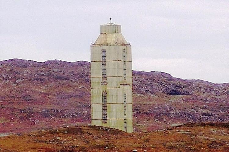
Kola Superdeep Borehole superstructure. (Andre Belozeroff / Wikimedia Commons)
Have you ever wondered what would happen if you kept digging into the Earth? How far down could you go? Could you dig right to the Earth’s core? What would happen if you did? The United States and the former Soviet Union separately attempted to find out from the 1960s to the 1990s. The result, on the Soviet side, was the Kola Superdeep Borehole that, at 40,230 feet (12,262 meters), remains the deepest artificially-made hole in the world.
The subterranean superpower race
The Earth has a rocky crust that goes down to around 50 km from the surface while the Earth’s core is at least 6730 km from the surface. Geologists from both the United States and the Soviet Union were eager to understand the geological composition of this crust and the Earth’s core beyond that, and, as in the case of the Space program, they embarked on a race to be the first to discover the mysteries that lay underneath.

CUSS I drillship used by the US for underwater drilling. (US Gov)
The United States took the lead in 1960 by starting Project Mohole under the sea off the Pacific Coast of Mexico. As compared to the crust on the Earth’s surface, the crust on the seafloor is thinner and the US Americans thought it would be easier to drill down from there. They began by sinking six large buoys underwater to a depth of 200 feet and positioning them into a circle. Then, using a sonar, they moved a Navy barge directly over the buoy circle and fixed an enormous rig in the centre of the circle.
Once the rig was in place, they began digging at 11,700 feet on the sea floor and dug under the crust until they reached a depth of 601 feet. At the point, in 1966, the US Americans ran out of funding and had to give up on the project.
On the Soviet side, they began their drilling project later in 1965, but they had the good fortune of having the project planned at least five years in advance. The Ministry of Geology of the USSR established the Interdepartmental Scientific Council for the Study of the Earth’s Interior and Superdeep Drilling for this specific purpose. Their detailed planning ensured that the project didn’t run out of funds at any time in the course of its duration and that they were able to carry out the drilling in the most feasible area.
The Council spent a long while in surveying various areas until they decided upon the site in the Pechengsky District in the Murmansk Oblast on the Kola Peninsula as the most appropriate one. They then took their time in constructing a proper rig for the drilling and building a protective rig enclosure; this enclosure was 200 feet tall, incidentally. They also prepared the right drilling machinery and invented new devices to facilitate deep drilling.
Regular deep-drilling rigs make use of a rotating shaft drill, but the Soviets perceived that this wouldn’t work as well at the very great depths they expected to go down to. Instead, they came up with a drill in which the shaft remained steady and only the drill bit at its end rotated. The Soviets designed the shaft to allow the pumping of drilling mud down its length and this mud put pressure on the drill bit and made it rotate and drill into the crust.
The Soviets called their borehole the Kola Superdeep Borehole and worked on it until 1994.
The Kola Superdeep Borehole
The drilling on the Kola Superdeep Borehole began on 24 May 1970. Rather than one borehole, the Kola Superdeep Borehole consisted of one main hole with several others branching off from it. The Soviets were to use two drilling rigs in the course of the project, the Uralmash-4E and the Uralmash-15000. They planned to dig through the Baltic Shield continental crust down to a depth of 49,000 feet.
By 1983, the drillers had dug down to 39,000 feet. They then stopped drilling until 1984 and, in the fallow period, Soviet scientists and politicians visited the site and there was much nationwide publicity about the borehole. Ordinary Soviet citizens followed news about the borehole and were proud that their country had succeeded where the United States had failed.
Resuming drilling in 1984, the drillers went down to 39,587 feet. At this point, on 27 September 1984, a drill string section fell off at 16,000 feet. They stopped the drilling and then restarted it at 23,000 feet.
In 1989, the deepest borehole, SG-3, went down to 40,230 feet. The SG-3, by the way, is only nine inches in diameter. The drillers then, perforce, had to stop drilling as the temperatures at that depth were incredibly high and adversely affected the drilling. By their calculations, the drillers had expected to encounter a 100 °C temperature, but, instead, it turned out to be 180 °C.
This very high temperature rendered the rock at that depth into a porous, permeable, and plastic-like state. This made drilling almost impossible as every time the drillers withdrew the drill bit for replacement, the plasticky rock flowed over and closed the drilled hole. The researchers attempted to get around the heat issue by pumping down ice-cold drilling mud, but that didn’t have the required effect.
With no solution apparent around this problem, the drillers had no other alternative than to stop further drilling. They were still 9,000 feet away from their early stated goal of reaching 49,000 feet.
Geological discoveries from the Kola Superdeep Borehole
In the course of the drilling, the Soviets were able to collect an enormous amount of geological data that shed an illuminating light on what we know about the Earth. Geologists had to abandon many previously held theories in face of the new factual data.
Before delving deep into the Earth’s crust, geologists collected necessary information from studies and surveys on the Earth’s surface and by recording seismic activities. From previous data, they noticed that the speed of seismic waves became faster at three to six kilometres below the Earth surface. The geologists assumed that this was on account of a change in the rocky crust, with the upper granite changing into a layer of basalt rock.
They called this presumed rock transition the Conrad discontinuity and discovered that it occurred beneath all the continents. At the Kola Superdeep Borehole, however, the drill failed to encounter it and they found that the granite rock extended down to 12 km and more. The geologists then came to the realization that the rock underwent metamorphic changes from the great heat and pressure at that depth and these changes were what caused the seismic-reflection results they had obtained. In short, the granite rock remained granite but underwent a structural change due to heat and pressure.
Plankton in the Kola Superdeep Borehole
On reaching the depth of six km, to the amazement of the Soviet geologists, they found microscopic fossils of planktons in the samples they extracted. There were 24 plankton species and test results pointed out that the fossils were at least two billion years old. Nitrogen and oxygen layers encased the fossils. It was incredible that they survived unscathed in the tremendous heat at that depth.
Underground water in the Kola Superdeep Borehole
Another incredible find at the Kola Superdeep Borehole was the discovering of water at the depth of 7 km. It seeped in the cracks of the granite rock. Where had the water come from though? The geologists surmised that mineral interaction probably produced it and that it remained there underground since it could not pass through the impermeable rock surface overhead.
The geologists also found hydrogen gas in the mud that they extracted from the borehole.
End of the Kola Superdeep Borehole
After drilling halted in 1989, the workers left and never returned to resume the work. The Soviet Union disintegrated in 1995, but the authorities took until 2005 to officially announce the scrapping of the project. In 2008, they dismantled the rig and buildings and fitted a steel cap over SG-3.

A photo of Kola Superdeep Borehole site from 2012. (Bigest / Wikimedia Commons)
The borehole, as of 2018, is the deepest artificially-made hole on Earth. To understand how deep it goes, compare it to the 10.91 km of the Challenger Deep in the Mariana Trench, the deepest natural point on Earth, and the 8.9 km high Mount Everest. The measurement of SG-3’s depth exceeds the Challenger Deep’s depth and Mount Everest’s height.
If you want to see samples extracted from the Kola Superdeep Borehole, you can see them in Zapolyarny, a town located some 10 km from the site and known for its nickel mines. It is in the Pechengsky District of Murmansk Oblast, Russia. You can also visit the site of the borehole itself and see the building ruins.
Enjoyed this article? Also, check out “Bingham Canyon Mine: The Largest Copper Producing Mine in the United States“.
Fact Analysis:
STSTW Media strives to deliver accurate information through careful research. However, things can go wrong. If you find the above article inaccurate or biased, please let us know at [email protected].
RELATED
 August 15, 2019 Demon Core: The Deadly Plutonium Core That Killed Two Physicists at Los Alamos National Laboratory
- May 27, 2020 Bartini Beriev VVA-14: The Cold War Scramble for Arms Gave Birth to an Amphibian Aircraft in Russia
- September 18, 2019 Understanding Day Length Fluctuations – What They Are and What Causes Them
 September 13, 2018 The Ghost Ship, the Flying Dutchman: A Parable or an Illusion, Fata Morgana?
The post Kola Superdeep Borehole: The Deepest Borehole in the World That the Soviets Drilled in the Kola Peninsula appeared first on .
]]>The post Body Worlds Exhibits by Gunther von Hagens: An Exhibition for the Better Understanding of the Human Anatomy appeared first on .
]]>
A gymnast at Body Worlds Exhibits. (Nick Webb / Wikimedia Commons)
The Body Worlds exhibits by Dr. Gunther von Hagens is a famously controversial exhibition that straddles art and anatomy. If you have ever wondered what the human body looks like from the inside and how the different bones, muscles, arteries, and inner organs look in different positions, this is the exhibition that will enlighten you. The exhibition features over 200 real bodies that include human babies, young people, middle-aged people, elderly people, and also animals.
These bodies have been stripped of their skin to reveal the interior parts in stark detail and the bodies have been preserved in a lifelike state by a complicated, lengthy, and expensive procedure called plastination. Most of us are not accustomed to seeing dead human bodies and so this exhibition can come as a shock to many visitors. People have reportedly fainted while visiting. People holding certain moral, religious, and political views have criticized the exhibition as being disrespectful and demeaning to human life.
Dr. von Hagens doesn’t appear to be fazed too much by these controversies; he has successfully defended his stance and his exhibits in court on several occasions. He shrugs off the controversies and states that the purpose of the Body Worlds exhibits is to display for visitors the entire spectrum of the cycle of life. He also hopes that by seeing the exhibition people will become better informed about the workings of their bodies and that they will then take better care of themselves and live in a healthier way.
Dr. Gunther von Hagens
Formerly a Professor of Anatomy at Heidelberg University, Dr. Gunther von Hagens has a doctorate in Anesthetics and Emergency Medicine. He teaches at Dalian’s School of Medicine in China and also holds the Directorial position at the Bishkek State Medical Academy’s Plastination Center in Kyrgyzstan.
In 2002, Dr. von Hagens performed an autopsy on the corpse of a 72 years old man and the autopsy was telecast live on Channel 4. An estimated 1.4 million people watched the live broadcast. This was the first publicly performed autopsy in the UK in 170 years.

Gunther von Hagens. (Nick Webb / Flickr)
Dr. von Hagens thinks there should be more of these in the line of the public body dissections that were once performed in Padua and Leiden in the 16th century and which inspired the dissection artworks of Leonardo da Vinci, Albrecht Dürer, and Rembrandt. He calls it the democratization of the human body. People should know more about their own bodies, rather than this knowledge being kept the strict preserve of the medical fraternity.
The Body Worlds exhibits
The first Body Worlds exhibition took place in 1995 in Tokyo, Japan. Ever since then, Dr. Gunther von Hagens has taken the show to 47 cities in various countries in North America, Europe, and Asia, and over 37 million visitors have seen the exhibition.
All the bodies in the exhibits have been donated by people before their death and Dr. von Hagens maintains strict records and documentation regarding this. That said, the exhibition does not inform visitors about who exactly these people were and what motivated them to donate their bodies for the purpose of the exhibition.
The exhibition is arranged in an order from comparatively fewer shocking exhibits to more shocking exhibits to acclimatize visitors to what some people have described as the overall ‘gory spectacle’. That said, nothing in the exhibition is presented simply for the shock value. The bodies are arranged in various poses, both for artistic effect as well to show how the bones, muscles, inner organs, and other interior parts operate.
Visitors can avail of written matter as well as audio guides as they walk around the exhibits. The detailed anatomical information provided in these include how muscles, tendons, and bones work to move fingers and other body parts, how the heart works, how the nerves, arteries, and veins work, and so on.

Body Worlds A male ballet dancer. (Nick / Flickr)
You can see how smoking and drinking affect your lungs and your liver, respectively. The exhibit has diseased or damaged lungs and livers placed next to healthy organs, so you can clearly see the difference. Many visitors find this more unsettling than any of the other exhibits.
The plastination technique
Dr. Gunther von Hagens developed the plastination technique more than 25 years ago and patented it. The first body he plastinated took over 1500 hours to complete and cost around 25000 pounds. Human bodies have 30 percent solid matter and 70 percent liquid matter. In the plastination technique, the bodily liquids and fats are replaced by first acetone and then a combination of epoxy resins, polyester, and silicone rubber material.

A man cut in half at the exhibit. (Pexels)
The result is a lifelike body with an intact-looking interior and no odour. Given the method of preservation and barring any destructive accidents, these bodies are likely to remain intact forever.
Quite a few people are attracted by the idea of preserving their bodies for eternity and Dr. von Hagens regularly receives donation offers and has over 3000 names on his roster. He has often spoken of his intention to have his own body plastinated after his death. While his reason to do so is to help advance the boundaries of human knowledge about anatomy and to foster better health care, the other folks have more prosaic reasons for wanting to join the exhibit. It is preferable to be exhibited, some of them feel, rather than to be buried or burnt.
Famous displays
Some of the famous displays of skinned human and animal bodies at the Body Worlds Exhibits include:
• A chess player pondering over a chessboard, with his brain visible in his cranium.
• A horse-rider, who holds his brain in one hand a whip in another, as he sits astride a leaping horse.
• An eight-month pregnant woman and the foetus in her womb.
• A cyclist hunched over his racing cycle.
• A pole vaulter with a pole in mid-jump.
The educational aspect of the exhibition
Many people have told Dr. von Hagens that visiting the exhibition gave them a better understanding of their body and heightened respect for it. According to Dr. von Hagen, a girl who had twice attempted suicide told him that she would never again do so. Knowing what is inside the body and what makes it work seems to fill people with the desire to treat their own bodies better.
The exhibition offers catalogues, posters, videos, and other teaching materials free of charge to schools for the edification of their students. An understanding of the human anatomy and the working of the human body is particularly important and essential for young and old people in the current world where certain parties with agendas have been busy encouraging the mutilation of healthy bodies as something socially acceptable for their own nefarious ends.

A man holding his brain while riding a horse. (Immanuel Giel / Wikimedia Commons)
Controversies & criticism
In 2004, according to a report by Der Spiegel, Dr. von Hagens obtained some bodies from Chinese and Kyrgyz authorities and these bodies were those of executed Chinese prisoners and dead patients from Kyrgyz hospitals. Dr. von Hagens returned some of these bodies, saying he did not know their origin and got an injunction against Der Spiegel for what according to him is a spurious claim.
Since Dr. von Hagens maintains strict control of the copyright of his exhibition and the plastination technique, he has taken legal action against competitors with similar exhibitions. According to the competitions, which include Bodies Revealed and Body Exploration, there are no grounds for a legal suit against them. They maintain that nobody has the right to copyright the poses of the human body.
The Body Worlds Exhibits have been widely criticized by religious and political figures as well as the self-appointed moral guardians of society
In 2009, a French judge ordered the closure of a Chinese Body exhibition and the seizure and burial of all the bodies and body parts displayed in it. In the UK, the Parliament enacted the Human Tissue Act in 2004 by which all exhibits of bodies and body parts must first obtain a license from the Human Tissue Authority. In Scotland, such exhibits are required to obtain a license from the Scottish Ministry. The Bishop of Manchester opposed a Body Worlds Exhibition in 2007, claiming such exhibitions meant less available organs for making organ donations for medical purposes.
Many countries have enacted legislation either to make it difficult to obtain bodies and body parts for such exhibits or to ban such exhibits altogether as violating the sanctity of human life and showing disrespect to the dead. It is interesting to note that, for all their desire to respect human life, many of these countries are yet to enact any legislation to make war illegal.
Enjoyed this article? Also, check out “The Unknown Fate of Einstein’s Stolen Brain“.
Fact Analysis:
STSTW Media strives to deliver accurate information through careful research. However, things can go wrong. If you find the above article inaccurate or biased, please let us know at [email protected].
RELATED
 April 28, 2018 Is the Story of ‘Zana’ the Ape-Woman who could Outrun a Horse True? or a Myth?
 May 30, 2020 The 19th Century Mechanical Toy—The Creeping Baby Doll
 January 10, 2020 Margaret Howe Lovatt: Strange Case of a Male Dolphin Falling in Love with a Young Lady
- August 21, 2019 Clever Hans: The Einstein Horse That Could do Math
The post Body Worlds Exhibits by Gunther von Hagens: An Exhibition for the Better Understanding of the Human Anatomy appeared first on .
]]>The post The Ghost Blimp L-8 and the Unexplained Disappearance of the Two US Navy Pilots appeared first on .
]]>
Ghost Blimp: U.S. Navy L-8. (National Archives)
Many strange events occurred during the Second World War and many of them remain unexplained till date. This is the case with the US Navy Blimp L-8, whose two-man crew disappeared without a trace in 1942. Despite a widespread search and a thorough investigation, the US naval authorities could not come up with any plausible and adequate explanation of why, when, and how the crew had abandoned the blimp and what had happened to them.
The mystery of the Ghost Blimp L-8
On 16 August 1942, at 6:03 a.m., US Navy Blimp L-8 took off from Moffett Field on Treasure Island in the San Francisco Bay on a routine mission. It was a clear day, with a calm sea, and you wouldn’t have known there was anything amiss with the world.
The Second World War was raging in Europe, Asia, and Africa, and the United States. After the Japanese attack on Pearl Harbour, United States was paranoid about being on the receiving end of Japanese attacks on the West Coast mainland. The L-8 was instructed to patrol the coast and look for Japanese submarines that might be lurking in the Pacific Ocean. The two-man crew was equipped with a .30 calibre machine gun and 300 rounds and two Mark 17 depth charges. If they spotted the enemy’s submarines, they were to make every effort to destroy them.
The L-8 flight was to last for four hours, after which the pilots were to return to Treasure Island to refuel and then go back on another patrol. At 7:38 a.m., the crew radioed their base to report that they had spotted an oil slick in the water four miles to the east of the Farallon Islands. They said they were going to investigate the area for possible submarine presence. That was the last radio contact the men made, but a Liberty ship, Albert Gallatin, and a fishing trawler, Daisy Grey, saw them after this time. The blimp had dropped two smoke-producing Mark IV float-lights or flares at 7:42 a.m. to aid them in better scrutinizing the area. The personnel on the ship and the trawler later informed the naval authorities that the blimp had patrolled the area for about an hour and they had seen the L-8 descend to 30 feet above the water surface at one point. The fishing trawler hurriedly pulled up its fishing nets, fearing that they would be ruined if the blimp unleashed one of its depth charges against a lurking Japanese submarine. Nothing alarming happened, however. No Japanese submarine appeared and, after the flares, the L-8 did not drop anything else into the ocean. The blimp and its crew looked perfectly alright to the watchers on the Albert Gallatin and the Daisy Grey. There was no indication of any kind of trouble.
Sometime after 9 a.m., the L-8 dumped ballast, rose back up in the air, and began its return journey to Treasure Island. Many eyewitnesses saw it on this return journey. None of them thought there was anything wrong with the blimp, although a few did notice it sagging in the middle.
There was no further radio contact, however, and the attempts of the naval base to establish contact came to nothing. They were not much alarmed since it was common for radio connections to fail on occasion. In addition, the pilots were experienced and had enough fuel to return to base. Even so, at 8:50 a.m., when they still hadn’t heard from the L-8, they sent two Vought OS2U Kingfisher floatplanes to conduct a search and informed other planes in the area to report to them if they saw the blimp.
A few reports soon trickled in. The pilot of a Pan Am Clipper called at 10:49 a.m. to say he had seen the L-8 over the Golden Gate Bridge. Then, at 11 a.m., one of the Kingfisher floatplanes reported they had seen the blimp ascend to 2000 feet three miles to the west from Salada Beach. Later, the pilot of an Army P-38 saw the blimp near Mile Rock. In all these sightings, the L-8 appeared to be in fine fettle.
The next person to see the blimp was Richard Quam, a Navy seaman who was off-duty and was driving along the coastal highway to spend the day on the beach. He thought something didn’t seem quite right with the blimp. There was a noticeable bend in its middle. He took a photograph out of sheer curiosity. The naval authorities later confiscated his camera film.

Ghost Blimp L-8 sagging in the middle. (National Archives)
When the blimp came inland, it was eight miles off course to the south of San Francisco. After nearly touching down on the Ocean Beach near Fort Funston, it continued onward and crashed into a nearby cliff. There was only one bather on the beach at the time and he reported later that the impact against the cliff dislodged a 325-pound depth charge that rolled out of sight down the hill. The impact also bent the starboard engine’s propellers. Considerably lightened by the unloading of the depth charge and although with a V-shaped sag in its middle, the blimp rose up into the air and continued onward.
The blimp passed over the Olympic Club golf course, astonishing a crowd of golfers. One of the golfers looked at the blimp through binoculars and told the naval authorities later that he had seen two men in the gondola. After passing over Lake Merced, the L-8 went over the Daly City BART station and Mission Street. By now, hundreds of people had spotted the blimp and, as it was now visibly deflating and appeared to be in trouble, they had begun running after it.
Soon the L-8 began losing height and, after scraping over rooftops and nearly getting entangled in telephone lines, it crashed into a house in Daly City and then landed in the middle of a street. The now deflated gas bag of the blimp draped over a car – the owner had been cleaning it just minutes before the blimp’s descent and had fled for his life when he saw it coming down on him – and the upturned gondola touched down gently and drew up against a telephone pole. When the onlookers rushed to it, they discovered there was no one on board. The door had swung open, with no sign of the safety bar, and two of the three life jackets were missing; since it was mandatory for the crewmen to wear life jackets at all times while on board, the life jackets had obviously disappeared along with the men that were wearing them. One of the crewmen’s hats was still there though, dangling on the controls, and a briefcase that contained secret codes was still locked in place. Also, on board were the rubber life raft and the three parachutes – putting into doubt the claim of one eyewitness that he had seen a parachute drop out of the blimp earlier; nobody was found in the reported area, despite a thorough search.
L-8 – The Ghost Blimp
The L-8 was manufactured by the Goodyear Tire & Rubber Company for promotional purposes. It was 150-foot-long and had a 47-foot diameter. It could hold around 123,000 cubic feet of helium and could attain a speed of 43 knots. It was powered by twin 145 horsepower Warner Super Scarab Type 5 engines.
When the United States entered the Second World War, the Goodyear company bowed to the US Navy’s requisition order and presented the L-8 and four other blimps to the US Navy to help with the war effort. The navy refurbished the L-8 and made it a part of the lighter-than-air Airship Patrol Squadron 32. They used the L-8 for sending supplies to offshore ships and to patrol the coast. The blimp and its gondola were in excellent condition. The blimp had made 1,092 trips without encountering any problem, and, moreover, it had undergone a thorough inspection prior to the flight.

L-8 blimp being used to deliver supplies to the USS Hornet. (U.S. Navy)
On that fateful day, the L-8 had been ordered to fly to the Farallon Islands, turn northward to Point Reyes, turn southward to Montara, and then turn back over the Golden Gate Bridge to Treasure Island.
The L-8 crew
The two-man crew were Lieutenant Ernest DeWitt Cody, 27, and Ensign Charles E. Adams, 35. They were both married, were experienced pilots, and had impeccable career records. They were both described as level-headed and competent.
Lieutenant Cody had graduated from Annapolis in 1938 and was not as experienced as Adams in piloting lighter-than-air flights. He had logged only 756 hours of such flights. Adams, on the other hand, had 20 years of experience in manning lighter-than-air flights and had logged 2,281 hours.
However, what he lacked in experience, Lieutenant Cody made up in determination and skill. Earlier in the year, in April 1942, he had delivered a 300-pound cargo of plane spare parts for the B-25 bombers to the USS Hornet; the vessel was carrying the bombers to Japan to carry out bombing raids over Tokyo. To deliver the cargo successfully, Lieutenant Cody had to hover over the ship, keeping the blimp steady, quite a piloting feat. He received a promotion for this successful cargo delivery.
Search for the missing L-8 crew
A widescale search was launched on air, land, and sea to find the missing crewmen, but they were never found. The naval authorities, under Commander Francis Connell, investigated the incident, and, in their seven-day-long inquiry, questioned civilians as well as naval personnel about what they had seen of the blimp on the day that its crew disappeared. Despite all the eyewitness testimonies, they could not come up with a reasonable explanation about what had happened. There was no sign that the blimp had been shot down or caught fire anywhere. Nor were there any sign that it had touched down at sea since its underside was completely dry and was dusty as well. There were also no signs of a fight or any other misconduct by the crew or a stowaway within the gondola.
A year later, with now new findings coming to light, the Navy closed the investigation, marking it as a 100% unknown and undetermined case, and then they legally declared the two missing men to be dead.
Theories about what happened to the L-8 crew
No one knows conclusively what happened to the two crewmen. Their bodies were never found, and nobody heard anything about them. How could they have disappeared without a trace in a busy city like San Francisco, and, moreover, right under official and public scrutiny? If anything had gone wrong, why hadn’t they radioed to inform the base? The radio, after all, was in perfect working order. There was no way they could have lost radio contact. Which meant they had either chosen not to make radio contact or they hadn’t been in the position to use the radio.
Over the years, people tried to come up with various explanations for their mysterious disappearance. According to one theory, it is likely that they climbed out of the gondola to carry out some repair work and fell to their deaths. Another theory is that perhaps the gondola door wasn’t barred as it should have been, and it swung open in mid-flight and they fell out. Perhaps the two men had a disagreement over flying the L-8 or over a woman they both like, and things grew violent and out of control and, in shoving one another, they ended up falling together out of the gondola.
Naval authorities dismiss these theories as nonsense. Cody and Adams were professional navy men and knew how to conduct themselves on a mission. Also, according to the code of operational technique, the airship crew was not supposed to bail out from the blimp when everything was working perfectly. Also, if they had fallen and died, the search teams ought to have found their bodies. Certainly, they couldn’t have fallen into the ocean, since many eyewitnesses reported seeing two men in the gondola as the blimp moved over San Francisco.
So, what could have happened to the airmen? Maybe they decided they wanted no part of the killing theatre that was the Second World War and went AWOL. Perhaps they were spying for Japan and escaped on a Japanese submarine. That again goes against the eyewitness testimonies.
Or, maybe, the Japanese submarine they were looking for, found them instead and forced them to jump at gunpoint. The Japanese then put their own men in the gondola and these were the men that onlookers saw from the ground below as the blimp coasted over San Francisco. What happened to the Japanese usurpers then? Perhaps they bailed out before the L-8 crashed and then they melted away into the city crowds to begin a spying operation against the United States. Well, that sounds exciting but not as exciting as the claim that it may have been Extra-Terrestrial Aliens that abducted the two men. Or that a shark jumped out of the water when they descended to look at the oil slick and grabbed them both.
Another theory put forward by researcher Otto Gross, is that, rather than looking for submarines, the L-8 was, in fact, conducting radar tests. Cody and Adams were knocked unconscious by the microwave radiation and, as the gondola door was improperly fastened, they probably fell out of the gondola. The US navy and army were conducting several top-secret research programs at this time, so there may be something to this theory. Given the secretive nature of the program, the bodies of the two men may have been retrieved and disposed off without informing the public.
What happened to the Ghost Blimp L-8 afterwards
The L-8, after being repaired, was returned to active service shortly after the disappearance of the crewmen. After the war ended, the Navy returned it to Goodyear, who refurbished it and began using it for promotional purposes once again. They renamed it America and it was in operation until 1982. The gondola of the L-8 is now on display in the Naval Aviation Museum in Pensacola in the Florida Panhandle.
Enjoyed this article? Also, check out “Hindenburg: The Tragic Death of World’s Biggest Commercial Airships“.
Recommended Visit:
Naval Aviation Museum | Pensacola, USA
Fact Analysis:
STSTW Media strives to deliver accurate information through careful research. However, things can go wrong. If you find the above article inaccurate or biased, please let us know at [email protected].
RELATED
- May 21, 2019 Hindenburg: The Tragic Death of World’s Biggest Commercial Airships
 October 12, 2018 Battle of Los Angeles: When the City Fought a Bizarre Battle with Nobody
- July 29, 2018 SS Baychimo: The Phantom Ship That Haunts the Arctic Waters
- May 10, 2018 Bloop: Large Mysterious Animal of the Deep Sea? or Ice quakes?
The post The Ghost Blimp L-8 and the Unexplained Disappearance of the Two US Navy Pilots appeared first on .
]]>The post The Egyptian Vultures of Tamil Nadu’s Vedagiriswarar Temple appeared first on .
]]>
A priest feasting the sacred Egyptian Vultures. (Edgar Thurston / Madras Government, India)
Some of India’s temples are famous not only for their architectural finesse, their beautiful surroundings, and the piety they invoke in believers but also for certain quite inexplicable happenings that continue to baffle onlookers. The Vedagiriswarar Temple is a fine example of this. For several centuries, the temple was famous for hosting a remarkable pair of birds that appeared exactly at noon to accept prasad from the temple’s priest.
The birds of Vedagiriswarar Temple
Nobody knows exactly when the birds started arriving at the upper temple, but they came regularly for many centuries. They alighted on a rock near the temple at noon on the dot and then the priest would feed them a prasad of ghee, sugar, rice, and wheat. If on occasion, the Egyptian Vultures did not show up, it was on account of the presence of sinners amongst the crowd (or) onlookers.
The Temple authorities and the devotees do not consider the Eagle Vultures to be ordinary birds, but there are differing folklores about what they actually are.
According to one version, the Eagle Vultures are the eight sages or Asthavasus who once displeased Lord Shiva and the quick-tempered God then cursed them to live as birds until they had performed penance. Lord Shiva ordered them to visit his temple in Vedagiriswarar to pray to him and receive prasad from the temple priests. The birds lived for three yugas or epochs, with six of the sages getting mukti (emancipation) and the last two surviving to the present epoch.
By another version, the Eagle Vultures are Sage Poosha and Sage Vruddha. They once prayed long and hard to Lord Shiva in order to obtain the elevated Sharoopa status. Lord Shiva, however, was willing to grant them only the Sayujya status at that time and said that he would consider granting them the Sharoopa status later perhaps when he thought they were worthier of it. Instead of accepting what Lord Shiva offered them, the two Sages argued with him and insisted on being given the Sharoopa status right then and there.
Angered by their insistence, Lord Shiva cursed them and turned them into Eagle Vultures and informed them that they would remain birds until the end of the Kali Yuga. In the meantime, they were to worship him at the Vedagiriswarar Temple. For generations, the birds followed his diktat and appeared at the temple. In the Thretha Yuga, they went by the names Sandan and Prasandan. In the Kritha Yuga, they called themselves Sambathi and Jadayu. In the Dhawapara Yuga, they called themselves as Sambhukthan and Mukundan. Now, in the Kali Yuga, they are Pusha and Vidhadha.
The local lore tells us that the birds daily fly across a distance of some 3218 km from Varanasi to Thirukazhukundram to feed at Vedagiriswarar Temple at noon and then first fly southward to Rameswaram and then northward to Chidambaram to spend the night there for some much-needed rest. The next morning, they fly to bathe in the Ganges in Varanasi and the return again by noon to Vedagiriswarar Temple.
Perplexing bird behaviour
Egyptian Vultures are birds that normally congregate in flocks and feed on carcasses. For only a pair to appear on a regular basis at Vedagiriswarar Temple and that too to feed on food that is not the natural food of Vultures is odd behaviour, if you consider the matter from a scientific point of view. Some bird researchers think that if the birds have been coming to the temple for centuries it is on account of learned behaviour that the parent birds have passed down to their progeny or from bird relatives to other birds.
The Egyptian vultures stop visiting Vedagiriswarar Temple
Since 1998, the Egyptians Vultures have stopped showing up at Vedagiriswarar Temple. It may be because there are too many sinners flocking in the area. Or it may be that the last pair of Ashthavasus has finally attained moksha. Or, more prosaically, the last pair of Egyptian Vultures failed to either raise a new generation or failed to point them in the direction of the temple or failed to cultivate in them a taste for the temple prasad.
No one knows what the reason is exactly, but the priests at Vedagiriswarar Temple continue to scan the skies and keep vigil in the expectation that the birds may one day return as they did in past centuries.
Vedagiriswarar temple
Dedicated to Lord Shiva and located in the town of Tirukalukundram, also called Thirukazhukundram, in Tamil Nadu, the Kings of the Pallava Dynasty built the temple and it displays some of the best elements of ancient Dravidian architecture.

Vedagiriswarar temple. (Simply CVR / Flickr)
Vedagiriswarar Temple is actually a temple complex that has two temples. One of the temples is at the foot of the hill and the other one is at the top of the hill. You must climb over 500 steps to reach the upper temple.
Lord Shiva resides in the upper temple and his consort, Parvati, resides in the lower temple. Vedagiriswarar is one of Lord Shiva’s many names and Parvati, in this instance, goes by the name of Thiripurasundari Amman.
Her temple, the Bakthavatchalaeswarar Temple, covers a large area of around 10 acres and has exquisite architectural features that include four gopurams, curved mandapams, and a high compound wall. The architectural style is similar to that of the Annamalaiyar Temple. There is also a huge water tank called Sangu Theertham that looks almost like a lake. The water contains minerals that confer it with health-giving properties and the priests use it to perform the abhishek rites on the temple deities. Devotees can drink this water.
Another remarkable thing about the Sangu Theertham is that every 12 years a Sangu or Couch Shell emerges from the depths and floats on the water surface. The priests have collected these Couch Shells and made them available for public viewing.
According to Hindu Mythology, Vedagiriswarar Temple sits on top of the tallest of the four Vedic hills – hence the name Vedagiri or mountain of the Veda – that Lord Shiva created to fulfil Sage Bharadhwaja’s wish to master the four Vedas. The Sage wanted to live for a very long time, so he would be able to learn everything in the Vedas.
Shiva granted him his wish but informed him that learning was a never-ending process and no matter how long one lived one could never know everything there was to know in the Vedas. Spending years learning the verses in the Vedas, therefore, wasn’t the proper way to attain to salvation. For true salvation, one needed genuine devotion or Bhakti.
In addition to being called Vedagiriswarar, devotees also call the temple Kazhugo Koil, which means an Eagle Temple, and they call the surrounding town Pakshi Theertham or a Pilgrimage Place of Birds. Interesting, the official name of the town, Thirukazhukundram, also pertains to birds in the Tamil language. Thiru means respectful, Kazhu means an Eagle or a Vulture, and Kundram means mount. So Thirukazhukundram means Respectful Mount of the Eagle or Vulture.
Thirukazhukundram is a very famous pilgrimage destination for Hindus and is about 15 km away from Mahabalipuram and 15 km away from Chengalpattu.
Enjoyed this article? Also, check out “Dhanushkodi: Where a Cyclone Ripped Apart an Entire South Indian Town, Rendering it Uninhabited“.
Fact Analysis:
STSTW Media strives to deliver accurate information through careful research. However, things can go wrong. If you find the above article inaccurate or biased, please let us know at [email protected].
RELATED
- December 12, 2018 Dhanushkodi: Where a Cyclone Ripped Apart an Entire South Indian Town, Rendering it Uninhabited
 January 17, 2019 Pamban Bridge: A Historic Indian Sea Bridge That Was Built on Modern Principles
 July 11, 2019 The Jewel of Manipur: The Loktak Lake is the Only Floating Lake in the World
- February 25, 2020 Leh Magnetic Hill: A Stretch of Road Where Laws of Gravity Work Peculiarly
The post The Egyptian Vultures of Tamil Nadu’s Vedagiriswarar Temple appeared first on .
]]>The post Pripyat, Ukraine: The Thriving Soviet Nuclear City That the Chernobyl Disaster Turned into a Ghost Town Overnight appeared first on .
]]>
Pripyat, Ukraine. (Jorge Franganillo / Flickr)
Well-known as the city that evacuated the day after the Chernobyl Disaster, Pripyat is now a ghost town in northern Ukraine, near the Belarus border. It is a place where nobody lives anymore, and which nature is slowly but surely taking over. One day soon, all its buildings might collapse, and the forest may grow over the remains.
The City of Pripyat, Ukraine
The Soviet government founded Pripyat on 4 February 1970 to house the workers and the scientists that arrived to work at the Chernobyl Nuclear Power Plant some 180 km from Kiev. Pripyat, which got its name from the nearby Pripyat river, was billed as the Soviet Union’s ninth nuclear city or atomograd and, by 1979, it was home to over 49,000 people of 27 nationalities. Demographic–wise, it was a young city, with most of its residents being in their early to mid-twenties.

Pripyat welcome sign. (Jorge Franganillo / Flickr)
It was a beautiful and vibrant city too, with over a hundred buildings and residences. There were several schools, playgrounds, stores, malls, restaurants, cafes, a cinema, a cultural centre, and a park. The city had stadiums, swimming pools, and gyms. There were factories, a railway station, a bus station, a car park, and a river pier.

A public pool. (Jorge Franganillo / Flickr)
If some people thought that the city was too close to the nuclear plant, it didn’t spread too much concern or alarm amongst the city folks. At the time, everyone considered the nuclear plant to be perfectly safe, a great feat of Soviet engineering that was using nuclear power to generate electricity only for the good and betterment of mankind.

An abandoned amusement park in Pripyat. (Clay Gilliland / Flickr)
The Chernobyl explosion
The very curious thing about the Chernobyl explosion is that it occurred not because of a lack of implementation of essential safety methods, but, quite the contrary, on account of a safety test taken too far.
During the midnight shift on 26 April 1986, the Chernobyl plant was shut down for scheduled maintenance and the nuclear plant’s employees used this opportunity to test the grid systems that kept the core of the reactor cool. They wanted to find out how the grid system would fare if the power went out and the emergency cooling system became inoperable. Would they still have enough electricity for the unit to continue working? Would the reactor still receive enough cooling water? To find out, they turned off the cooling system. If the test went as planned, inertia-generated electricity from the plant’s electric turbines was to have worked the cooling water pumps for about 45 seconds before the three backup diesel generators kicked in and gained the power required to operate the main pump.
As we know, the test did not go as planned. There was an appalling lack of communication between the operators conducting this test. The operators who were going off shift did not adequately brief the operators replacing them, possibly expecting deputy chief engineer Anatoli Dyatlov to have a firm grasp on things as was his wont. The new operators, in turn, were too much in awe of him to express the quibbles they experienced regarding the plant’s reaction as they continued with the test.

Chernobyl Nuclear Power Plant. (Vadim Mouchkin / IAEA)
As the turbines slowed, the cooling water pumps slowed the water flow and steam bubbles formed in the core. These caused the RBMK reactor to embark on a positive feedback loop. The steam bubbles prevented the coolant from absorbing neutrons and this increased the reactor’s output, producing more steam and more power. To counteract this and limit the power, the automatic control system began inserting control rods into the reactor core.
Then someone pressed the AZ-5 button to initiate an emergency shutdown of the reactor. There is no record of why they did this, but once done, it fully inserted all control rods into the reactor core. It was the worst thing to happen in that situation. The graphite-tipped control rods were supposed to slow the reaction by inserting neutron-absorbing material, but as the design of the control rods was flawed, they displaced the coolant instead and speeded up the rate of reaction.
This built up towards a power surge that overheated the core and caused the first explosion. A few seconds later, there was a second, more powerful nuclear explosion.
This explosion in the plant’s reactor no. 4 at about 1:23 a.m. sent the roof of the nuclear plant flying into the air and released several hundred tons of toxic material into the surrounding areas.
Effect of the Chernobyl Explosion
According to nuclear experts, the strength of the explosion was over 100 times of that of the bomb that exploded in Hiroshima. The toxic radioactivity spread across the entire vicinity of the plant and, aided by the winds, crossed borders to contaminate areas of Belarus, Ukraine, Russia, and even Poland.
Of course, the public in these regions did not immediately realize what had taken place, since the Soviet government maintained a tight-lipped silence about the disaster in its immediate aftermath and for a quite a long while thereafter, but, in the months and years to follow, many were to die from radiation-related illnesses and many continue to suffer and die. It is common in these areas to hear cases of thyroid cancers and of babies being born with physical deformities, all attributed to the long-term effects of the radiation.
Meanwhile, fire raged at the Chernobyl nuclear power plant and thousands of rescue workers and volunteers attempted in vain to douse it out with water. It took much stronger methods and several months of strenuous efforts before the fires were finally extinguished and, in the process, many brave individuals lost their lives and many others their health.
The evacuation of Pripyat
The morning after the Chernobyl explosion, on 27 April 1986, the residents of Pripyat realized something was very wrong from the smoke that was streaming out into the sky from the direction of the nuclear plant. The authorities then swung into action and ordered an immediate evacuation of the city. People grabbed what they could of their belongings and boarded buses that were waiting to remove them from the compromised city.
As they left, very few imagined that they might never see their homes again, but that’s exactly how things turned out. Instead, they found themselves rehomed six months later in the new city of Slavutych, 30 miles away from the Chernobyl nuclear power plant.
The current status of Pripyat
The Ministry of Emergencies in the Kiev Oblast is responsible for Pripyat and the entire Chernobyl zone and closely monitors the areas with the highest radioactive contaminations. The government continues to do as much as possible to tackle and reduce the contamination levels, including building a special steel shelter over reactor no. 4.
The city remains uninhabited, however, and is likely to remain so for nine centuries still. That is how long it will take to get rid it of its radioactivity. It is safe, however, to pass through its roads and spend a few hours looking around abandoned city and many curiosity-filled folks come on regulated, guided tours, well-equipped with Geiger counters, to the Zone of Exclusion to get a feel of life after a disaster; the Zone of Exclusion, by the way, is the large swath of area around the nuclear power plant that has the misfortune of having the highest amount of radioactive contamination.

Pripyat being consumed by nature. (Jorge Franganillo / Flickr)
This isn’t a place where a great many tourists flock to though, mainly because of concerns of radioactive contamination as well as the acute discomfort brought on by the absolute silence of the place. You can never forget that people lived here once and, due to a disaster of immense proportions, now they don’t.
At the same time, it is as if the place remains stuck in a time-wrap. You get an eerie feeling of being back in the old Soviet days and any moment soon, the people might emerge from the various buildings and get on with their daily lives. Perhaps you will hear children laughing as they run home from the Pripyat School, as they play in the once-popular Pripyat Park, or as they splash about in the Pripyat Swimming Pool. Perhaps you will see the much-photographed and never used Ferris Wheel turn in the Pripyat Amusement Park; this Park was on the verge of its inauguration at the time of the disaster.

Pripyat school. (Aliaksandr Palanetski / Flickr)
During the city’s evacuation, the residents had to leave all their belongings behind and these remain here still. If, after nine centuries, the city gets new inhabitants, they will find these relics of historical interest. Right now, nature is busy taking over as much of the city as possible. The buildings are decaying with water damage and have moss growing on their walls. Bushes, grasses, and weeds have taken over the sidewalks.

Inside Pripyat school. (Jennifer Boyer / Flickr)

A classroom inside Pripyat school. (Shanomag / Wikimedia Commons)
On the outskirts of Chernobyl, the feeling of abandonment grows stronger. The Soviet army’s immense assembly of tanks, trucks, all-terrain vehicles, and helicopters lay rusting in neat lines. As they have been contaminated with the radiation, nobody can ever again use them, not even for scrap metal.
The Resurgence of the Wildlife in Pripyat
Immediately after the nuclear explosion, a large section of a forest of scotch pines died from exposure to the radioactive dust and turned into a rusty orange colour. In its attempts to reduce radiation levels, the Soviet government bulldozed the dead trees and buried their remains. Other trees in the area, however, appear to have escaped similar damage, although the soil still shows very high radiation concentration.
Researchers are still studying the effects of the nuclear explosion on the animals and birds in the Chernobyl region. There are some reports of mutations and smaller-than-normal brains in birds and smaller animals, but larger animals don’t seem to exhibit as much or any side-effects of radiation contaminations. In fact, they seem to be thriving in the absence of humans. Researchers report seeing dogs, wolves, lynxes, deer, bears, bison, moose, wild horses, badgers, weasels, beavers, and wild boars in the area as well as birds like egrets, owls, swans, storks, eagles, kestrels, and harriers.
If you ever wondered what would happen to the earth in the event humans disappeared, this ought to give you an inkling. The planet will do just fine without us.
Enjoyed this article? Also, check out “Varosha: The Abandoned Luxury Retreat in the Mediterranean“.
Special thanks to Jorge Franganillo on Flickr for releasing photos under Creative Commons.
Optional Visit (Caution):
Pripyat | Ukraine
Fact Analysis:
STSTW Media strives to deliver accurate information through careful research. However, things can go wrong. If you find the above article inaccurate or biased, please let us know at [email protected].
RELATED
 February 14, 2019 Kolmanskop: From Being the Richest Town to Now Being Devoured by the Desert
 March 17, 2019 Duga Radar: Unravelling of the Mystery Behind the Soviet Woodpecker
 July 2, 2019 Varosha: The Abandoned Luxury Retreat in the Mediterranean
- March 26, 2019 The Disappearing Aral Sea and its Abandoned Ships
The post Pripyat, Ukraine: The Thriving Soviet Nuclear City That the Chernobyl Disaster Turned into a Ghost Town Overnight appeared first on .
]]>The post The Pando Tree of Utah – The World’s Largest and Oldest Living Organism appeared first on .
]]>
Pando tree, quaking aspen. (J Zapell / Wikimedia Commons)
In Latin, the word Pando means ‘I spread out’. This is an apt name for the world’s most famous Quaking Aspen tree that is over a million years old and which, through its shoots, covers an area of around 106 acres at an elevation of 8,848 feet in the Fishlake National Forest’s River Ranger District in Utah, United States.
The ‘Pando’ quaking aspen tree
Burton V Barnes, a botanical researcher, came across the Pando tree in 1968 and was the first researcher to discover that it wasn’t a grove of different trees but, in fact, a single tree with all the stems displaying the same morphological characteristics. The tree received its name ‘Pando’ from the University of Colorado’s researcher, Michael Grant, who, in 1992, called it the world’s largest living organism. It is also the world heaviest known living organism with an estimated weight of 6,000,0000 kilograms.
How the Pando tree grew to be so extensive
The Pando tree developed from seed over a million years ago when the Earth’s climate was vastly different from what it is at present. It thrived and survived over the centuries, but around 10,000 years ago, the Earth’s climate began to change. The region, which once had heavy rainfall and a humid climate, transformed into a semi-arid landscape. This affected the Pando and all the other aspens in the region and curtailed their ability to flower and then produce seeds.
According to researchers, the Pando tree hasn’t produced flowers and seeds ever since and has reproduced through the suckering method. This involves sending up erect clone stems through its lateral root system. The root system spread across a vast area and the new stems thus sprang up at a considerable distance from the main tree. Since the other aspens weren’t seeding and producing new aspens and the Pando appears to have been particularly aggressive in its spread, it had little or no competition from other aspens in the extensive growth.

A trunk from the Pando aspen grove. (Scott Catron / Wikimedia Commons)
The frequency of forest fires in the area also assisted the extensive spread of the Pando tree. These fires prevented the abundant growth of the conifers that would otherwise have competed for space and nutrients with the Pando. The fires, incidentally, had little or no effect on the Pando or its underground root system and the tree was able to keep on proliferating.
At present, the Aspen has over 47,000 stems that look like individual trees and the average age of these stems is 130 years. Known collectively as the Ramel, these stems have all sprung from a root system that is at least 80,000 or more years old. It is not possible to date the root system precisely, so it may very well be even older.
Is Pando tree dying?
After centuries of prolific growth, the Pando tree may now be in a decline. According to a study that researchers published in October 2018, it appears that the tree’s growth slowed down some 40 years ago and this may be an indication that it is dying.
Sections of the grove have thinned as many of the stems have died and toppled over. While it is natural for the stems to die and fall, the problem is that they are not being replaced by new stems at the same rate as the die-offs.
The tree can only live on if it continues to send out new stems, in much the same manner as a human town or country will only continue to thrive if it has young people to take the places of the old. If there are no young people, there will be no one to replace the old when they die, and the town will fall into ruins. Without a regular growth of new stems to replace the old, it is likely that Pando’s future too will be bleak.

A male mule deer. (Yathin S Krishnappa / Wikimedia Commons)
Climate and environmental factors aside, the principal danger to the Pando tree is from grazing cattle and mule deer. These animals graze in the aspen grove and either eat or trample on young aspen shoots before they have the chance to develop and grow. As the population of mule deer has grown rapidly in recent times, with no predators like wolves to cull it down naturally, they pose a very big threat to the Pando and the other aspens.
Other threats to the Pando tree include root rot and bark beetle.
Conservation efforts to save the Pando tree
To prevent the decline and to help the tree live on, conservationists are checking all possible causes for the tree’s decline and taking steps to mitigate these.
The Utah State University’s S.J. & Jessie E. Quinney College of Natural Resources has established a research group called the Western Aspen Alliance. They are studying the Pando grove to find a way to save the tree. The United States Forest Service is carrying out several conservation experiments in five acres of the Pando aspen grove to find the most practical ways to save it. They have succeeded to an extent in promoting the growth of new stems and, to protect these, they have fenced off the grove sections to keep out of the mule deer.
However, the attempt to fence off sections of the groves to keep out the mule deer has not worked. The deer have still managed to get across and damage the growing aspen shoots.
There are two things that the authorities can do to save the Pando, first reintroduce wolves in the region to keep the deer population down and, second, issue more licenses in the hunting season.
It may also help to relocate the camping ground that is currently too close to the aspen grove. The mule deer have been congregating around this camping ground for the food they can find here and because there are no hunters in this area. By law, hunters cannot shoot near human habitations to prevent accidents and injuries, and the mule deer, being smart creatures, have come to realize that they will be safer in such areas. So, they hang around the camping grounds and then graze in the aspen grove and, as mentioned, destroy the chances of the new growth.
Culling the mule deer seems a cruel practice, but it is to be either that or to somehow move them en masse from the area. That is the only way the Pando tree will have a chance to continue surviving for a million years more.
Enjoyed this article? Also, check out “Greenland Shark: The Longest Living Vertebrates to Swim The Arctic Ocean“.
Fact Analysis:
STSTW Media strives to deliver accurate information through careful research. However, things can go wrong. If you find the above article inaccurate or biased, please let us know at [email protected].
RELATED
- August 30, 2018 Saving the Kakapo – The World’s Strangest Parrot
- January 8, 2019 Proboscis Monkey: The Rare Borneo Monkey Species with an Unusually Long Nose to Lure Its Females
- April 12, 2019 The Wave in Arizona: A Geological Wonder
- June 19, 2020 Tree of 40 Fruits: A Patchwork Canopy of Myriad Fruits
The post The Pando Tree of Utah – The World’s Largest and Oldest Living Organism appeared first on .
]]>The post Thich Quang Duc’s Self Immolation – The Vietnamese Buddhist Monk Who Set Himself on Fire appeared first on .
]]>
Thích Quảng Đức after setting himself on fire (Colourised). (Malcolm Browne / AP)
Even if you are not very familiar with Vietnam’s history, you may have come across the famous photograph of a Buddhist monk seated on a Saigon street, engulfed in flames. It is one of those shocking images that, once seen, is hard to erase from the memory. You might wonder what the person taking the photograph was thinking at the time and what the person undergoing the unbearable act of self immolation was feeling. The monk was Thích Quảng Đức, a Vietnamese monk of the Mahayana Buddhist sect, and his self-immolation on 11 June 1963 on a busy street intersection in Saigon was a planned public protest against the anti-Buddhist policies and persecution of Vietnam’s Roman Catholic President Ngo Dinh Diệm.
The photograph was taken by an American journalist named Malcolm Browne and he later received the Pulitzer Prize for capturing the monk’s last moments.
Persecution of the Buddhists in Vietnam
To understand how a Roman Catholic minority could persecute a nearly 80 percent Buddhist majority, we will need to go back to Vietnam’s colonial past. The French ruled over the country from 1884 to 1954 and one of their ‘civilizing’ policies was to enforce their Roman Catholic faith on to the traditionally Buddhist Vietnamese people.
They showed more favour towards the Vietnamese that knuckled under and converted to Roman Catholicism than to the Vietnamese that resisted all “civilizing” attempts and clung stubbornly to their ancient faith.
If you wanted to advance in your career, especially in a government post under the colonial rulers, you would have higher chances of managing it if you renounced Buddhism and became a Roman Catholic. Many Vietnamese took the practical point of view and switched their religions. It is entirely possible, of course, that some of them may have been genuinely convinced that along with the financial windfall, it would bring them a spiritual bonanza as well.
In any case, so by the time the nationalists ousted the French and Ngo Dinh Diệm became the President, there was a Roman Catholic elite in the government and the years of colonial rule had sufficiently bamboozled them into imagining that religion mattered more than a common shared ancestry and cultural heritage. They continued the French policy of assuming a superior attitude and looking down on the nation’s Buddhist population.
If you were a Buddhist in Vietnam at the time, you would face difficulty in securing a government job, and, once you did, you would find yourself being passed over for promotion. It was the same story if you were in the Vietnamese army. In the rural areas, the government could force you to leave your village and move to a less favourable location. They could prevent you from receiving the aid that the US Americans sent to the Vietnamese people.
They could refuse to give you the arms and ammunition that they distributed to Roman Catholic village militias for self-defence purposes, and they would not interfere when these latter militias harassed you, looted your wealth, shelled your homes, demolished your Buddhist shrines, and tried to force you to convert to their religion. The government would also force you to perform the corvée labour which you didn’t have to do if you were a Roman Catholic.
There were instances of people converting en masse to avoid these and various other persecutions.
The Vietnamese government also retained the old French diktat of making Buddhism a private religion. This meant that you could only worship the Buddha in private and it was illegal to perform any public Buddhist rituals or even fly the Buddhist religious flag in public, even in a Buddhist religious shrine. Meanwhile, the Roman Catholics could take over the streets with their religious parades if they wanted and fly the Vatican flag at will whenever and wherever they wanted.

President Ngo Dinh Diem. (Department of Defense / National Archives)
To home in the point further, President Ngo Dinh Diệm paid homage to the Virgin Mary on his nation’s behalf in 1959. According to him, even though Buddhism was the religion of the majority, it had no place in his vision of modern Vietnam.
The Buddhist monks of Vietnam took the lead in protesting against such discrimination and began demanding an equal treatment for all citizens.
They reacted to the ban on the Buddhist flag by marching with a huge crowd to the government broadcasting station on Gautam Buddha’s birthday, Huế on Vesak, in early May, defiantly holding forth their Buddhist flags. The government responded by firing on them, killing several of the protestors. The brutal response shocked the nation, but President Ngo Dinh Diệm was unapologetic and remained determined to crush all Buddhist opposition.
Far from being cowed, the Buddhists gathered reinforcements and heightened their anti-governmental agitation. International onlookers like the US Americans took notice and began pressuring the government to meet the demands of the Buddhists. President Ngo Dinh Diệm hedged around the issue and did exactly nothing.
Thích Quảng Đức
The senior Buddhist monk, Thích Quảng Đức, now made his appearance on the stage of world events.
Born in 1897 as Lâm Văn Túc, Thích Quảng Đức came from a rural family of modest circumstances and began studying Buddhist precepts at an early age from his maternal uncle. Becoming a monk when he was 20, he took on the Dharma moniker of Thích Quảng Đức and embarked on a lifelong mission of spreading the Buddha’s message throughout Vietnam.
Over the years, he built himself a solid reputation as a capable individual with strong principles.
The self-immolation of Thích Quảng Đức
Convinced that a drastic action was necessary to force the government’s hand, Thích Quảng Đức decided that there was no other course than self-immolation.
Vietnam had a long history of monks immolating themselves to protest against governmental policies.
The main difference between the previous incidences and this one was that members of the Western Press had not had the opportunity to capture those instances.
On this occasion, the Buddhist monks informed the Western journalists in advance that something major was going to happen and they should come to the predetermined location at the set hour. Interestingly, most of the journalists took no notice and did not bother to turn up. Buddhists protesting against governmental iniquities had become all too common and more or less old news and they didn’t think there would be anything of note to report.
Only a handful of reporters came, Malcolm Browne of the Associated Press amongst them.

The car Thích Quảng Đức arrived in. (RG72 / Wikimedia Commons)
As many of the journalists recollected later, the Buddhists came in a car procession and stopped at the intersection. Thích Quảng Đức emerged from the car in yellow robes and sat down in the middle of the street, assuming the lotus position. Another monk took a can of gasoline from the car and proceeded to pour it down the seated monk’s shaven head. Thích Quảng Đức remained composed and serene. When the monk finished pouring the gasoline and stepped back, Thích Quảng Đức calmly lit a match and dropped it down in his lap. His body instantly caught fire.

A monk assisting Thich by pouring gasoline on him. (AP Photo)
The watching public and the journalists shouted out in horror, but the ablaze monk remained seated, not moving a muscle, his expression retaining its tranquillity.
In about ten minutes, the fire burned him to a black mass and then the other monks approached and carefully draped a cloth over him and placed his body into a prepared coffin.
They gave him a religious cremation later and discovered in its aftermath that the flames failed to burn his heart and it remained intact.
Reactions to Thích Quảng Đức’s Self-Immolation
The immediate public reactions of disbelief and horror found a 100-fold echo when newspapers around the world published and republished Malcolm Browne’s iconic and disturbing photographs. Foreign governments and especially the US government, under President John F. Kennedy, were quick to condemn President Ngo Dinh Diệm and his government and hold them responsible for the monk’s gruesome death.

Malcolm Browne (right), the photographer of the controversial photo interviewing Quang Lien (left), the spokesman for the Xa Loi Buddhist pagoda. (AP Photo)
President Ngo Dinh Diệm attempted to carry out damage control by addressing the nation in a radio broadcast later that night and informing the listeners that he was about as much disturbed by the self-immolation as everyone else in the country. He promised to investigate the issues the Buddhists were protesting and to make any necessary reforms.
He had no intention to follow through on this public promise and very few of the public believed he would. His sister-in-law Trần Lệ Xuân, the wife of Ngo Dinh Nhu, his younger brother and right-hand man, was openly scathing about the monk’s self-immolation. She announced she would clap her hands at another spectacle of a “monk barbecue.”
A few days later, the government’s ARVN Special Forces began raiding, looting, and damaging Buddhist shrines around the country. During one of these raids, they seized Thích Quảng Đức’s heart, which his associates had carefully safeguarded since his cremation. The government proclaimed that the monk was probably a CIA asset that the CIA had drugged and forced to commit suicide. If not that, perhaps Malcolm Browne had paid him to immolate himself just to get an attention-grabbing photograph.
The Times of Vietnam, which was the government mouthpiece, accused the monks and the journalists of colluding to destroy the Vietnamese government, with the monks paying the journalists for their libellous reports with the services of young Vietnamese girls.
The aftermath of Thích Quảng Đức’s self-immolation
The Buddhists stepped up their protests in the coming weeks and months and still more monks followed in Thích Quảng Đức’s footsteps and burned themselves.
While their self-sacrifice did cause more consternation with the general public and with foreign governments, it is doubtful that it would have had much of an effect if a timely, CIA-approved army coup by Vietnamese army officers in November 1963 hadn’t dislodged President Ngo Dinh Diệm from office. He and his brother Ngo Dinh Nhu were then summarily shot.
Of course, the CIA cared little or nothing for Thích Quảng Đức’s martyrdom. Their objective, as ever, was regime change to benefit US interests.
Trần Lệ Xuân, who was then in California and who would go in lifelong exile in France, decried the deaths of her husband and brother-in-law with the statement – “No coup can erupt without American incitement and backing”.
They would pay for this “indelible stigma”, she declared. This would be just the start of their troubles in Vietnam and, thanks to them, the country would have a dreary future.
The outbreak of the Vietnam War just a few years down the line proved her right.
Recommended Read:
The Vietnam War: An Intimate History | By Geoffrey C Ward & Ken Burns
Fact Analysis:
STSTW Media strives to deliver accurate information through careful research. However, things can go wrong. If you find the above article inaccurate or biased, please let us know at [email protected].
RELATED
 May 18, 2019 Animal Suicide: Do Animals, Like Humans Resort to Ending their Own Lives?
- August 1, 2019 Tiger Temple: A Clandestine Tiger-Breeding Facility Run by Monks
- March 27, 2020 The Insidious Practice of Bear Bile Farming
 December 10, 2019 Loung Pordaeng: The Bespectacled Monk Mummy of Wat Khunaram
The post Thich Quang Duc’s Self Immolation – The Vietnamese Buddhist Monk Who Set Himself on Fire appeared first on .
]]>The post The Soyuz 11 Tragedy – The Death of Three Soviet Cosmonauts in Space appeared first on .
]]>
Photo of Soyuz 11 crew. (USSR Post / Wikimedia Commons)
Travelling to where no man has ever gone before sounds glamorous in theory, but comes fraught with all manners of dangers and even fatalities in practice. In space travel, where we are confronting the unknown, it can be difficult and even downright impossible to predict how things are going to turn out, despite the most stringent preparations. The Soyuz 11 tragedy is an example of this, and the very first instance of humans dying in space.
Soyuz 11 and the first space station in earth’s history
The Salyut 1, which the Soviet Union launched into the earth’s lower orbit on 19 April 1971, became the first space station in our planet’s history. Now all that remained was to get people on this space station. The Soviets succeeded with this as well on 7 June 1971, when the Soyuz 7k-OKS, a spacecraft designed for space station flights, docked the Soyuz 11 capsule at the space station. An earlier space mission, Soyuz 10, had docked but failed to properly latch on and the cosmonauts had therefore been unable to enter the space station.
There were three cosmonauts onboard Soyuz 11: The Commander, Georgy Dobrovolsky, the Flight Engineer, Vladislav Volkov, and the Test Engineer, Viktor Patsayev. It was a first space flight for Georgy Dobrovolsky and Viktor Patsayev, and the second for Vladislav Volkov. As it turned out, unfortunately, it was also to be the last flight for all three.
Record-setting stay at the Salyut 1 space station
Nobody had ever stayed in space on a space station, so it was a very big event when the Soyuz 11 crew not only docked successfully but also managed to latch on and enter it. They did encounter an immediate problem of a smoky interior due to a faulty ventilation system, but they soon fixed that problem. They had to retreat to their capsule and wait until the air cleared, but they were able to go into the space station and remain there after that. They stayed at the station for almost 23 days and, during this period, a large percentage of the public in the Soviet Union assiduously watched the televised broadcasts that the cosmonauts made. There was great curiosity about what it was like to live in a space station and the cheerful cosmonauts helped their audience experience it second-hand. In addition, the Pravda newspaper, the official newspaper of the Communist Party, published regular updates of the cosmonauts. They became very popular with the general public.
There were some problems at the space station, but the crew managed to deal with these. They put out a fire on the eleventh day of their stay and allayed the fears of the ground crew that they might have to abandon the station. The crew discovered that station vibrated from end to end when they used their treadmills. They postponed the launch of an N1 rocket. They remained healthy and in good spirits till the end of their stay and set the very first record for human endurance in space.
Soyuz 11’s return to earth
After what seemed to have been a very successful and illuminating space mission, everyone eagerly awaited the return of the cosmonauts. The Soyuz 11 capsule re-entered the earth’s atmosphere on 30 June 1971 and made a good landing on a flat, uninhabited plain in Kazakhstan.
The recovery team approached the capsule, which had landed on its side, and found it to be remarkably undamaged on the outside, without even a dent anywhere. They knocked on the capsule exterior, but there was no answering knock from within. Filled with foreboding, they forced open the hatch and found themselves confronting an unexpected and horrifying sight. The three cosmonauts were lying on their couches, seemingly unconscious, with blood streaming from their noses and ears and vivid blue marks on their faces. Commander Dobrovolsky’s body was still warm, which gave the rescuers some hope. They hurriedly removed all three from the capsule and performed CPR to try and revive them. It was to no avail. The three cosmonauts were already dead.
Death on the Soyuz 11
The ground crew had become concerned after losing audio contact with the cosmonauts as the Soyuz 11 capsule re-entered the earth’s atmosphere. They had come prepared for emergencies, but finding the crew dead in this manner was a shock. It seemed inexplicable too, given that the capsule was undamaged.
According to the doctors who performed the CPR, the crew had died from asphyxiation. Later, pathologists at the Burdenko Military Hospital carried out autopsies on the bodies and discovered that the cosmonauts had died from blood vessel haemorrhaging that occurred mainly in the brain, but also to an extent in the nose, ears, and skin. The haemorrhaging resulted from a sudden drop in pressure in the capsule’s interior; the blood vessels ruptured when the nitrogen and oxygen in the bloodstream bubbled from the pressure drop. The pathologists also found inordinately high amounts of lactic acid in the blood, signalling extreme stress before death occurred.
Data from the biomedical sensors on one of the cosmonauts showed that the cosmonaut had a cardiac arrest within 40 seconds of the pressure drop. The capsule’s interior pressure had dropped to zero within 15 minutes of the retrofire.
What had caused the pressure to drop though?
Cause of the decompression on the Soyuz 11
Investigators examined the capsule thoroughly to discover the cause of the decompression and finally found that it was due to the inadvertent opening of a breathing ventilation valve.
These ventilation valves were between the orbital module and descent module and the spacecraft engineers had designed them to shut automatically during descent. Alexei Leonov, the Commander of the original crew, had expressed doubts about this automatic shutting of the valves. He had advised the Soyuz 11 crew to not trust the automatic function and, instead, to close the valves manually. They had, unfortunately, either forgotten or disregarded this advice.
He had been right, it turned out. The automatic closure failed when the explosive bolts holding the orbital and descent modules fired simultaneously, instead of, as expected, firing sequentially. With the force of the simultaneous firing, the valve seal loosened and opened the valve when the capsule was at an altitude of 168 kilometres. The pressure inside the capsule dropped instantaneously. Since the position of the valve was in between the seats, the cosmonauts were unable to find and block it to prevent the air escaping from the capsule.
During the examination of the capsule after the tragic flight, Leonov tried closing the valve manually and discovered it took him up to a minute to do that. In an emergency situation, such as the one that the Soyuz 11 crew had encountered, a minute was too long.
If the cosmonauts had worn space suits, they might have survived. After the Soyuz 11 tragedy, the Soviets redesigned the Soyuz aircraft to hold only two crew members with space suits. A later redesign in 1981 allowed space for three crew members with space suits.
The funeral of the Soyuz 11 crew
The mood of the nation turned from expectant joy to sombre grieving. Nobody had expected the events to take such a tragic turn. The Soviet government organized a massive state funeral for the three cosmonauts and the burial took place in the Kremlin Wall Necropolis in the Red Square in Moscow. They later received posthumous medals as Heroes of the Soviet Union.

Soyuz 11 Memorial in Kazakhstan, built exactly where the module had been found. (Vikkom0203 / Wikimapia)
The Soviet state media did not announce the cause of their deaths until almost two years later.
The Soyuz 11 tragedy alarmed the US Americans who were preparing for their Skylab program. They assumed that the Soviet cosmonauts had died from their extended stay in a zero-gravity environment, and, of course, they did not want to risk the same thing happening to their astronauts. Charles Berry, a NASA doctor, discounted this theory. It was more likely, he said, that the cosmonauts had died from toxic inhalation. The space program authorities found this explanation more to their liking and continued with the space program.
Enjoyed this article? Also, check out “Lost Cosmonauts of USSR: Did the Soviet Union Cover up its Secret Cosmonaut Casualties?“.
Optional Visit:
Soyuz 11 Memorial | Kazakhstan
Fact Analysis:
STSTW Media strives to deliver accurate information through careful research. However, things can go wrong. If you find the above article inaccurate or biased, please let us know at [email protected].
RELATED
 December 17, 2019 Lost Cosmonauts of USSR: Did the Soviet Union Cover up its Secret Cosmonaut Casualties?
- August 7, 2019 Ham – The Chimpanzee that Paved Way for Launch of Manned Spacecrafts
- June 25, 2018 Laika the Canine Cosmonaut – From the Streets to the Stars
- July 3, 2018 Space Burial: Making Skies Our Cemetery
The post The Soyuz 11 Tragedy – The Death of Three Soviet Cosmonauts in Space appeared first on .
]]>The post AMARG: The US Plane Graveyard Where Aircraft are Stored, Stripped, Repaired, and Restored appeared first on .
]]>
Aerial Photo of retired military planes at 309th Aerospace Maintenance and Regeneration Group. (U.S. Navy photo)
The 309th Aerospace Maintenance and Regeneration Group (AMARG) holds a special fascination for aviation enthusiasts. Located at the Davis-Monthan Air Force Base in Tucson, Arizona, AMARG stores and maintains various types of aircraft and missiles on its 2,600-acre facility. Since quite a few of these aircraft fall in the vintage or out-of-service category, a popular nickname for AMARG is The Boneyard. It is certainly a veritable graveyard for planes.
The plane graveyard
After the wholesale destruction and senseless mayhem of the Second World War ended, the United States emerged as a mostly unscathed, powerful nation with a surplus of aircraft. It was necessary to store these aircraft somewhere for later use or to strip them for spare parts. In 1946, the US government established a new base for the 4105th Army Air Force Unit in Tucson in Arizona for this purpose.

Satellite photo of The Boneyard. (USGS)
While the purpose of the facility remains the same to the present day, the name of the facility has undergone several changes over the years. It became the newly independent United States Air Force’s 3040th Aircraft Storage Depot in 1946. The government dubbed it the Military Aircraft Storage and Disposition Centre (MASDC) in 1965. Later, in the 1980s, it became the Aerospace Maintenance and Regeneration Centre (AMARC). The 309th Maintenance Wing took over command of AMARC in May 2007, and the centre now became the 309th Aerospace Maintenance and Regeneration Group (AMARG).
The dry climate of the area is conducive for storing aircraft since low humidity means less rust and corrosion. It also helps that the hard soil makes moving the planes around easier.
Planes and missiles at the facility
The US government stored the bomber aircraft, Boeing B-29 Superfortress and the military transport aircraft, Douglas C-47 Skytrain, at the base after the Second World War.
In the 1960s, the US armed forces sent their out-of-service aircraft to this base. The Navy initially had their own plane graveyard at Naval Air Station Litchfield Park in Goodyear in Arizona, where they sent all the coast guard, navy, and marine planes. But, in 1965, they moved 500 of these to the Davis-Monthan Air Force Base. Three years later, in 1968, they closed Litchfield Park.
In addition to processing aircraft, the facility at the Davis-Monthan Air Force Base began dismantling intercontinental ballistic missiles in the 1980s. These missiles are also reused for launching satellites.
On 31 July 1991, the United States and the Soviet Union signed a bilateral treaty to reduce and limit strategic offensive arms, and this treaty came into force on 5 December 1994. To comply with this treaty, AMARC began dismantling 365 B-52 bombers. The Soviets could view this dismantling via satellite and by on-site inspection at the facility. AMARC initially used a 13,000-pound, crane-supported, steel-cable guillotine to chop the B-52s to pieces. Later they used K-12 rescue saws. The latter made it possible for AMARC to gather more salvageable spare parts.

Retired B-52 bombers. (JOC Lon Cabot / National Archives and Records Administration)
Storage and processing at AMARG
AMARG stores aircraft in an intact state for long-term use and for shorter stays. The aircraft technicians repair some aircraft for the Department of Defence’s reuse. In the case of aircraft that they cannot repair for reuse, they take them apart completely and salvage spare parts from them.
Before putting any aircraft into storage, AMARG processes it carefully. The technicians remove the plane’s classified hardware and the charges under the ejection seat. They wash the plane thoroughly with clean water to remove dust and residue. They drain the fuel system, refill it with lightweight oil, run the engines, and then drain the oil. Doing so coats the fuel system plumbing and engines with a protective oil layer.
To protect the aircraft from dust, heat and light exposure, the technicians spray the aircraft with two coats of protective plastic compounds. Spraylat is one such vinyl plastic compound and its application includes a black coat to seal the aircraft and a white coat to keep the temperature down. The sprayed aircraft can then safely remain in its designated spot for a good while without incurring any long-term damage.
Every year, AMARG receives several hundred aircraft for storing and several hundred aircraft for reprocessing. Out of 300 aircraft, they may repair around 100 to send them to provide a flying service with the US military, the US coast guard, the US forest service, and NASA. The US government may sell the repaired planes to foreign governments. There is a special Foreign Military Sales program for this purpose. On the processing front, the facility strips around 200 aircraft for spare parts and manages to salvage parts worth $500 million. The US government and military are the main customers for these spare parts. The US government requires permission from the US Congress to make any other sales.
Around 500 civil servants from the Department of Defence and 200 contractors work at AMARG.
Some famous aircraft at AMARG
Boeing Vertol CH-46 Sea Knight
After the North Vietnamese defeated them in the Vietnam war in 1975, the United States used this helicopter to airlift the last remaining Marines from the rooftop of the US Embassy in Saigon.
Boeing NASA’s KC-135A Stratotanker
In its heyday, this aircraft had two well-deserved nicknames, the Weightless Wonder and the Vomit Comet. NASA used it for zero-gravity flight training for astronauts and the training wasn’t kind on the stomach.

KC-135A Stratotanker. (Alan Wilson / Flickr)
Lockheed LC-130
Used by the U.S. Navy, this aircraft was sent to Antarctica on a resupply mission and crashed there in 1971.
Lockheed C-5 Galaxy
The US Air Force has been using these cargo jets from 1969 to the present day. These are huge planes, with heights of around 65 feet and wingspans of 222 feet.

Lockheed C-5 Galaxy. (Tech. Sgt. Frank Oliver / U.S. Air Force photo)
Visiting AMARG
Regular access to AMARG is strictly limited to Department of Defence employees and people with the proper governmental permission and security clearance. However, the general public can visit the facility on the bus tour that the Pima Air & Space Museum conducts from Monday to Friday. You must make your reservations 10 days in advance and get a security clearance from the Davis-Monthan Air Force Base. In both cases, they will ask you for ID proof like a driver’s license for US citizens and a passport for Non-US visitors. The tour is accessible for handicapped people, but you must inform the museum in advance as they may need to make extra preparations.
The general public can also participate in annual running or walking sports events organized at the base. Or they can see it in various films and TV programs; AMARG is popular as a filming site.
Explore the area on Google Maps.
Enjoyed this article? Also, check out “The Disappearing Aral Sea and its Abandoned Ships“.
Fact Analysis:
STSTW Media strives to deliver accurate information through careful research. However, things can go wrong. If you find the above article inaccurate or biased, please let us know at [email protected].
RELATED
- July 23, 2018 Nauru: An 8 Square Mile Island That was Once the World’s Richest Country
- March 26, 2019 The Disappearing Aral Sea and its Abandoned Ships
- May 2, 2019 What Happens to the Olympic Venues in the Host Countries After the Olympic Games End?
- February 18, 2019 The Ryugyong Hotel of North Korea: The Tallest Unoccupied Building in the World
The post AMARG: The US Plane Graveyard Where Aircraft are Stored, Stripped, Repaired, and Restored appeared first on .
]]>The post Lake Crescent: Washington State’s Beautiful, Deadly Lake and its History of Chilling, Notable Incidents appeared first on .
]]>
Lake Crescent, Washington, United States. (Elwhajeff / Wikimedia Commons)
Lake Crescent is one of the deepest lakes in the United States. It was formed by the melting of ice-age glaciers and is in the Olympic National Park in Washington State. An area of stunning natural beauty, it is popular with hikers, kayakers, sightseers, and fishermen. There is, unfortunately, also a dark side to the lake. Its icy waters have claimed many victims and, given its great depth, some of them were never found. As for the ones that did get found, it was only after many years had elapsed that the lake let up its secrets.
Lake Crescent
The first thing visitors notice about Lake Crescent is its pristine, blue waters. There is a high nitrogen content in the water, which prevents the growth of algae and that is the reason for the extreme clarity of the water. The lake, when seen from above, forms a rough crescent shape. It didn’t get its name for its shape though, but from the Port Crescent Improvement Company which was trying to set up a new town called Port Crescent in Clallam County in the late 1800s. As part of their efforts to attract prospective investors and townspeople to the new town, they started a local newspaper, the Port Crescent Leader, and described the natural environment around the town site. In this promotion, the lake, which earlier discoverers had named Lake Everett, became Lake Crescent and that is what it has been called ever since.

Outline of Lake Crescent. (Eian Ray / Wikimedia Commons)
Apart from the ice-cold waters, the lake has treacherous depths with silt beds and tiers of craggy cliffs. According to the National Park Service, the official depth of the lake is 624 feet. A depth of 1000 feet has also been recorded, however. In 2014, surveyors discovered that the previous depth measurements were in error and the deepest point of the lake measured 650 feet. The lake is spread across 5,127 acres and is 19 kilometres long. It is home to a variety of fish, notably the Beardslee trout and the cutthroat trout. These fish were once anadromous or migratory, but about 1000 years ago, a tremendous earthquake caused a landslide that dammed up the lake. The local Klallam tribe’s mythology describes this event, although they claim that the Mount Storm King caused the landslide to punish the Klallam and the Quileute tribes for fighting one another and disturbing the peace.
People kayaking at a distant in Lake Crescent. (Jonathan Miske / Flickr)
The Olympic Mountains stand guard around Lake Crescent. On clear days, there is an exceptional serenity to the environment that charms all visitors. You would not associate such a beauteous lake with any unpleasant undertones. There have, however, been several strange and notable events associated with the lake that cannot be ignored. They have given the lake a rather sinister reputation and you might very well believe it if you happen to see the lake in stormy weather, with the wind howling and the waves crashing wildly. It is almost as though it is lashing about in frustration, waiting for its victims to show up and be swallowed up in its deep, freezing waters.
Let’s look at some of the notable incidents that happened on Lake Crescent:
1929: The Warren Couple and their 1927 Chevrolet
On 3 July 1929, Russell Warren, 35, and his wife Blanch Warren, 33, were driving back to their home in a logging camp on the Bogachiel River from Port Angeles. The route they took was the narrow, dirt road skirting along Lake Crescent. Blanch Warren had been hospitalized for some unknown ailment in Port Angeles and Russell had driven there to fetch her back. Along with picking up his wife, Russell Warren paid a $100 outstanding grocery bill, made the latest instalment payment on his car, and bought a washing machine that he put in the back of the car. The couple was looking forward to celebrating the US Independence Day on 4 July the following day. They had made plans to visit the Sol Duc Hot Springs with their two boys, Charles and Frank, aged 11 and 13 respectively. The boys were home alone, with only $35 for any emergencies that might crop up while their parents were away.
The Warrens never reached home. They and their 1927 Chevrolet vanished without a trace. Two weeks later, on 16 July 1929, the Port Angeles Evening News reported that the couple was missing, and the local sheriff conducted a two-month-long investigation. They found car skid marks, broken glass, and a cap that belonged to Russell Warren at Madrona Point near the lake; it was called Madrona Point because a Madrona tree in the nearby hills was visible from the location. The investigators dredged up Lake Crescent and sent divers to search the depths of the icy waters, but with the diving equipment that was available at the time, the divers could only go down to a depth of 78 feet. They were unable to find anything trace of the missing couple. An eyewitness stepped up to say that he had seen a car crash into the lake, but it turned out, that accident had happened two weeks after the Warrens disappeared.
After an extensive search that produced no results, people began to doubt that there might have been an accident. Perhaps the couple had just abandoned their children and taken off somewhere. Friends and family of the Warrens dismissed this as unlikely. They were not the type of people to do such a thing. The doubts lingered on though and their own sons were affected by the rumours.
For the next 73 years, the whereabouts of the Warrens remained a mystery. Their sudden and unexplained disappearance devastated their sons and scarred them for the rest of their lives. They were sent to live with their maternal grandmother in Montana, but that did not work out. Frank soon ran away, and Charles left too shortly afterwards. They did not get along with each other and went their separate ways and did not keep in touch for many years. Both came to tragic ends. The elder son, Frank, became an alcoholic and died of pulmonary congestion and oedema at the age of 57 in Maple Valley in 1972. The younger son, Charles, disappeared on 14 June 1964 when his fishing boat, a 35-foot Mildred G, collided with another vessel in a fog and sank off the coast of Northern California in 1964. He was 47 years old when he vanished. Their surviving families believed what they and everyone did for a long time, that their callous and uncaring parents had left them to fend for themselves.
Then, in 2002, volunteer divers and a search team from the National Park Service discovered their 1927 Chevrolet at a depth of 166 feet at the west end of Lake Crescent. They found the vehicle to be in intact condition. It was lying on its left side, on a steep slope, some 60 feet away from the lake shore near Ambulance Point on U.S. Route 101. The bodies of the couple were not found. It is assumed that they lost control of the car and hurtled off the dirt road and fell into the lake. The road, incidentally, is now higher than it was in 1929 and has been fitted with safety guard rails.
The Warrens’ great-granddaughter, Kristine Coachman, 32, thanked the divers and the search team for clearing up this disturbing part of their family history. The search efforts were conducted over a period of 11 months by district ranger Dan Pontbriand. The overseer of the 144,000-acre Olympic National Park, became intrigued with the case after he heard the story from Bob Caso, a local man. Since it seemed more likely to him that the Warrens had met with a bad end in Lake Crescent rather than have left their sons in such an abrupt manner, Pontbriand decided to investigate the matter. The search team was aided by Gene Ralston who used a side scan sonar to search in the lake. This tool is attached to the back of a boat and dragged in the water. The sound waves it emits bounce off objects in the lake’s depths and their locations are marked so that they can be examined later. The searchers found several cars, some of which were Ford Model A vehicles, in the lake. It was puzzling. Had there been so many car accidents in the lake? Then they heard that a carjacking gang had been stripping and dumping cars in the lake in the 1930s and, more probably than not, these cars were their handiwork.
After pinpointing the car’s location, the team sent in divers and they finally found the car.
The relieved Warren family and their relatives requested the car to be left in the lake as a fitting resting place for the couple.
1940: Hallie Illingworth – Lady of the lake
In June 1940, a woman’s body was discovered floating in the lake. The body had a rather strange white colouration and the face was no longer identifiable and the skin on the fingertips had worn away. Other than that, the freezing lake waters had preserved it in near perfect condition. The loss of the facial features and fingerprints clearly pointed to the body’s having been submerged in Lake Crescent for a very long time. The woman had once been tethered to weights that had kept her underwater, but the ropes had frayed away over time. The body had then been pushed up to the lake surface. The whiteness of the body, it turned out, was the result of saponification. The chemicals in the lake waters had reacted with the woman’s body fat to turn her skin into soap.
A further examination of the body revealed the woman had been strangled to death. There were also bruise marks on the body.
At first, nobody knew who the woman was, and, since forensic science wasn’t as advanced then as it is now, there seemed little way of finding out. The only clue was a dental plate that was found on the corpse. Deciding to see where that lead, Hollis B. Fultz, the criminal investigator on the case, published photographs of the dental plate in several dental magazines and asked if anyone had any information about it. A dentist from South Dakota saw the photographs and recognized the dental plate as one that he had himself made a few years earlier. A look through his records came up with her name. She was Hallie Latham Illingworth, originally from Kentucky, and she had moved to Washington for better work and life prospects. Here, she had worked as a waitress at a local tavern, had married for the third time, and had then abruptly gone missing in December 1937. When her family had inquired about her whereabouts, her third husband, Montgomery Illingworth, had informed them that she had eloped to Alaska with a new lover, a sailor. He had filed for a divorce five months afterwards and had remarried and moved to California.
Now that the body was conclusively identified as hers, the police contacted her ex-husband Montgomery Illingworth, a former beer truck driver, who denied it was his wife. Their neighbours and friends, however, identified the clothes as hers. They also informed the police that the couple had been prone to having frequent wild and violent fights and that Hallie Latham Illingworth had often sported bruises from being beaten up by him. On several occasions, the neighbours had to summon the police to intervene and stop the fights. A search through the husband’s place led the researchers to find a rope whose strands matched those of the rope that had been used to bind the dead woman. It became clear that the husband had murdered his wife during one of their fights and had chosen to dispose of her body in Lake Crescent.
The police arrested Montgomery Illingworth and he was put on a jury trial in Port Angeles. He continued to first deny that it was his wife and then deny any involvement with his wife’s death, but the evidence against him was too strong. The jury pronounced him guilty of second-degree murder in 1942 and he was sentenced to life imprisonment. He served nine years at the Washington State Penitentiary in Walla Walla until he was paroled in 1951. He died in 1974 in California.
1956 & 1960: Ambulance Point on Lake Crescent
This location on the lake got its name after an ambulance swerved off the road and hurtled into the water on 27 August 1956. The ambulance was from a hospital in Port Angeles and was returning after picking up an injured lumberjack in Forks. The lumberjack, a man named Ernest Monroe Dahlgren, had broken his leg and was strapped on to the gurney to protect him on the journey to Port Angeles. Unfortunately, this turned out to be a fatal aspect for him. Since he was tied down in this manner, he was unable to escape the ambulance after it crashed into the water. He went down into the lake depths with it. The two medics accompanying him were able to get out in time.
There was another incident at Ambulance Point on 24 January 1960, when a Dodge sedan skidded on the icy road and plunged into Lake Crescent. The car belonged to a man named Dan Steele and he had three other people with him in the car. They all managed to escape the would-be watery grave and swam safely to the shore. One of them, Beverley Sherman, when she heard about the discovery of the Warrens’ car in 2002, contacted the divers and asked if they could also find the Steele car. If they could, she said, she wanted her suitcase back. The divers located the car and got her suitcase from the car’s trunk. After over 40 years, Beverley Sherman was reunited with her lost possessions.
2007: Israel Keyes – a serial killer
A former US army soldier, Israel Keyes, moved to live in Neah Bay in Washington state after leaving the army. According to the testimony he gave to the FBI, he was driven to commit his first murder here because the town was ‘boring’. He later moved to Anchorage in Alaska and turned into a full-fledged serial killer, planning each murder with meticulous care. His murderous spree lasted from 2007 to 2012, when he was finally caught and charged with the murder of a 17-year-old girl. His other crimes were revealed during his interrogation and the investigators learned that he had dumped one of his victims in Lake Crescent. Keyes later committed suicide at the Anchorage Correctional Complex.
Enjoyed this article? Also, check out “Pink Lakes: Where Rose-Tinted Lakes Surrounded By Lush Greenery Are Truly a Sight to Behold“.
Fact Analysis:
STSTW Media strives to deliver accurate information through careful research. However, things can go wrong. If you find the above article inaccurate or biased, please let us know at [email protected].
RELATED
- October 16, 2018 Clear Water Lagoons and Pristine White Sand Dunes of Lençóis Maranhenses National Park
- May 9, 2020 Elephant Beach: The Dazzling Sandy Beach in Andaman and Nicobar Islands Perfect for an Exotic Vacation
- June 18, 2019 Bingham Canyon Mine: The Largest Copper Producing Mine in the United States
- January 15, 2019 Pink Lakes: Where Rose-Tinted Lakes Surrounded By Lush Greenery Are Truly a Sight to Behold
The post Lake Crescent: Washington State’s Beautiful, Deadly Lake and its History of Chilling, Notable Incidents appeared first on .
]]>The post Deep Blue – The IBM Chess Computer That Beat Chess Grand Master Garry Kasparov in 1997 appeared first on .
]]>
Garry Kasparov playing chess with multiple opponents, 1985. (GFHund / Wikimedia Commons)
Deep Blue was a chess-playing computer that IBM developed which became famous for playing a game against the reigning chess champion, Garry Kasparov, in 1996, and winning a match against him in 1997.
Origins of Deep Blue

An identical version of the Deep Blue at Computer History Museum, California. (Jim Gardner / Flickr)
In 1985, three computer science students at Carnegie Mellon University, Feng-hsiung Hsu, Thomas Anantharaman and Murray Campbell, built the chess-playing computer ChipTest. From this computer came a more improved version, Deep Thought. The project caught the attention of IBM and, after Feng-hsiung Hsu and Murray Campbell graduated, the company hired them to develop the Deep Thought project further. Thomas Anantharaman joined the company sometime later, but, after a short stint, left IBM to go work on Wall Street. IBM then roped in another programmer, Arthur Joseph Hoane, and their long-time employee, Jerry Brody, to join the team. Chess players Nick DeFirmian, Miguel Illescas Cordoba, and John Fedorowicz worked on the computer’s chess game. Randy Moulic and Chung Jen Tan were the team managers.
From Deep Thought, they developed Deep Blue, using the C programming language and the AIX operating system. IBM had a contest to come up with a suitable name for their chess computer and the name Deep Blue was the winner.
Deep Blue vs Garry Kasparov
On 10 February 1996, the reigning chess world champion, Garry Kasparov, won a chess match against Deep Blue. It was big news. Everyone thought it remarkable that a computer could play chess with anyone, never mind with a reigning world champion. The computer won one game in a six-game match. Of the remaining five games, Garry Kasparov won two and three ended in draws. Kasparov won the match as a result.
Nobody was surprised that the reigning world champion won. Not in the least the Grand Master himself. He had already announced to the world that there wasn’t a machine around that could beat him.
After the defeat, IBM took their computer back for a serious upgrade, contracted a chess player, Grandmaster Joel Benjamin, to help them refine Deep Blue’s opening book, and then contacted Garry Kasparov for a rematch the following year.
This time around, in May 1997, Deep Blue won the six-game encounter with a 3.5-2.5 win. Whether it won the match fair and square is another matter and a subject of controversy. Garry Kasparov didn’t think it had and accused Deep Blue and IBM of cheating.
According to Kasparov, the computer showed such unexpectedly creative and sophisticated moves in the second game that it was probable that, in violation of the rules, human chess players had dipped their oars into the chess game. IBM denied it had cheated and maintained that its computer program developers had only modified the program, which the game rules allowed them to do. The company refused to let Kasparov see their computer logs, however, and also turned down his demand for a rematch. Instead, they retired and dismantled their digital champion.
Deep Blue versus human intelligence
IBM continued to claim though that it was a historic man versus machine match that the machine ultimately won. Everyone doesn’t agree with this view. Several chess masters, who have studied the match, feel that Garry Kasparov wasn’t at his very best during the match and made a few regrettable opening mistakes. Also, he was placed at a disadvantage with the machine. Deep Blue’s programmers had studied his past games and strategies and had altered their program algorithms to adapt to his style. They also tweaked and modified the program in between games. Kasparov, on the other hand, had no inkling of the computer’s game and the modification in between the games further put him at sea.
Deep Blue was capable of thinking six to eight moves ahead, sometimes even twenty or more moves ahead, while, according to Kasparov, he was accustomed to thinking three or five moves ahead. Also, unlike humans, Deep Blue stood in no danger of tiring from an entire day of chess playing and making mistakes due to fatigue, frustration, and anxiety.
Even so, if you consider that the computer was programmed to gauge 200 million positions in one second, Kasparov comes out looking very good in comparison.
Interestingly, what Kasparov claimed to be a sophisticated move on part of Deep Blue was nothing of the sort, according to the computer’s programmers. Fifteen years after the famous chess match, they told reporters that what Kasparov had taken to be intelligent human intervention was actually nothing more than a bug in the coding.
Deep Blue was followed by Fritz, a German chess program. Garry Kasparov played a match against Fritz in 2003 that ended in a draw.
Today, a chess-playing computer is no longer unique. It has become too ubiquitous. However, difficult chess programs remain in wide demand as chess masters used them to improve and refine their games.
Deep Blue and artificial intelligence
IBM’s real purpose in developing Deep Blue wasn’t to humiliate Chess Grand Masters but to tout the cause of artificial intelligence. We hear of artificial intelligence all the time nowadays. Back then it was a novelty, and, with its chess computer, IBM wanted to give the public a glimpse of the immense possibilities of artificial intelligence. If it could play a chess game so well, just imagine how useful it would be in running the world and ridding us of human-created errors.
What these purveyors of artificial intelligence rarely mention – and what is actually glaringly obvious – is that if artificial intelligence ever comes to reign over us, it will be as in the actual reality of democracy, the reign of a few over the mass of the public. The few that will code the program for artificial intelligence will get to decide how the rest of us are to live and exist. It is not at all a comforting scenario. Imagine having your entire life at the mercy of an unknown computer programmer. If they are magnanimous, broadminded people with a talent for writing errorless code, you will have nothing to complain about. If they are not, you might end up having nowhere to complain to.
Enjoyed this article? Also, check out “The Turk: The 18th Century Automaton Chess Player was a Fore-Runner of Computer Age“.
Recommended Visit:
Computer History Museum | California, United States
Fact Analysis:
STSTW Media strives to deliver accurate information through careful research. However, things can go wrong. If you find the above article inaccurate or biased, please let us know at [email protected].
RELATED
- November 4, 2018 The Turk: 18th Century Automaton Chess Player was a Forerunner of Computer Age
 April 10, 2019 Euphonia: The Sad Story of Joseph Faber and His Creepy Machine That Made Ghostly Sounds
- February 22, 2019 The Summoning of Demons: The Dangers of Artificial Intelligence
 August 23, 2019 Laszlo Polgar – The Hungarian Psychologist and Educator Who Raised Three Chess Prodigies
The post Deep Blue – The IBM Chess Computer That Beat Chess Grand Master Garry Kasparov in 1997 appeared first on .
]]>The post Vaimanika Shastra – Treatise on Ancient Indian Flying Machines or Pseudoscience? appeared first on .
]]>
The Vaimanika Shastra is a Sanskrit text about ancient Indian flying machines or vimanas. While many ancient Indian scriptures mention vimanas and give elaborate descriptions of their workings, this is a more recent text that describes the ancient flying machines in detail. Yes, the Vaimānika Shāstra is not an ancient text. Or, at least, it is supposed to be by an ancient author, but comes to us through a modern medium. An Indian mystic Pandit Subbaraya Shastry claimed he had received the book as a divinity from the ancient sage Maharshi Bharadwaja and he then dictated it to his associate Shri G. Venkatachala Sharma. The dictation and transcription of the book lasted from 1918 to 1922. It was translated into Hindi in 1959 and into English in 1973.
The Vaimanika Shastra
Vaimanika Shastra means the science of aeronautics. To understand aeronautics, we need to understand aerodynamics, propulsive devices, materials, and metallurgy. In Vaimanika Shastra, there is much about propulsive devices, but next to nothing about aerodynamics.
The book’s focus is on the vimanas that were mentioned in many ancient epics like the Rigveda, Mahabharata, Ramayana, and others. According to the Vaimanika Shastra, these vimanas were not flights of fantasy of the ancient authors, but actual and aerodynamically viable flying machines. The ancient Indians not only knew how to fly, they also flew in highly sophisticated machines with many capabilities. Using mercury vortex engines, these vimanas could become motionless in mid-air and could make themselves invisible. When used in war, they could render the enemy forces unconscious and spy into the insides of enemy crafts.
The text includes information about piloting these vimanas and the aerial routes that could be taken. It mentions the food that could be eaten and the clothes that could be worn aboard the vimanas. It states the metals that were used to manufacture the vimanas and explains how these metals were produced. It describes mirrors fitted on the vimanas and their use in wars. It talks about different airplane machineries as well as different plant categories like mantrik, tantrik, and kritak. It also lists four planes – Shakuna, Sundara, Rukma, and Tripura – from the kritak category.
Origins of the Vaimanika Shastra
According to Pandit Subbaraya Shastry, Maharshi Bharadwaja is the real author of the work; it is indeed written as such. Apparently, Panditji was only the conduit for presenting the book to humankind. The verses would come to him in sudden flashes of inspiration and his associate Shri G. Venkatachala Sharma would then immediately transcribe them. This continued over a long period until the entire book was written. Sometime between 1900 and 1919, Panditji asked Ellappa, a draughtsman from an engineering college, to illustrate the manuscript with technical drawings of the vimanas.
Shri Shivkar Bapuji Talpade, who was a technical instructor at the J.J. School of Art in Bombay, became acquainted with Pandiji and created models of the planes with Panditji’s direction. He was unable to make them fly, however. Incidentally, Talpade was first modern Indian to build a flying machine that he named Marutsakha and flew on the Chowpatty beach in Bombay in 1895.
Panditji’s son, Shri Venkatrama Shastry, kept the original, illustrated manuscript after his father’s death in 1941, but Panditji’s followers distributed copies of the book amongst themselves and their circles. An Indian air force officer, Air Commander Goel, first read it in 1944, and apparently gave it to the Baroda University Library.
In 1951, a certain Shri Josyer founded the International Academy of Sanskrit Research and organized an exhibition of rare Sanskrit manuscripts at its inaugural event. Shri M.C. Krishnaswamy Iyengar, who knew Panditji, provided a copy of the Vaimanika Shastra for this exhibition and it generated a good deal of interest. Shri Josyer then contacted Shri Venkatrama Shastry and acquired the original manuscript. He translated it into English and made it available to the wider public.
Pandit Subbaraya Shastry
Pandit Subbaraya Shastry was born in Hosur taluka in Madras District in an impoverished family. He was married by the age of eight, as was the custom in those times, and several years afterwards, his parents died and the responsibility of supporting his many siblings fell upon his young shoulders. The only way he could do this was by begging. For a brief while, his father-in-law took in the family, but then they had to leave and fend for themselves once again. In these dire circumstances, they contracted smallpox and Panditji lost his sisters and one of his brothers to this disease. He himself became gravely ill and his surviving brothers abandoned him.
He would probably have died if he hadn’t been rescued and treated by a certain Guruji Maharaj near Kolar in Karnataka. Under the Guruji’s care, he recovered from the illness and took his first steps in the realms of spiritualism and mysticism. He never received any formal schooling, but learned to read and write Telugu and Kannada while he was with Guruji.
When he had completed recovered, he went to Anekal and lived there with his wife and the son they adopted some years later.
It should be mentioned that Panditji was an individual with an unassuming and unpretentious disposition. Over the years, he developed a wide circle of acquaintances, including the Indian scientist Jagdish Chandra Bose, and none of these people ever cast a doubt on his intrinsic sincerity.
He never took personal credit for the Vaimanika Shastra but insisted all the while that the real author was Maharshi Bharadwaja. He did not claim to understand the shlokas that he was divinely inspired to quote, nor did he claim to understand the practicalities of the flying machines in the Vaimanika Shastra.
The problems with the Vaimanika Shastra
While it would be a stretch to call Panditji a trickster or a charlatan – since he never showed any such traits in his entire life and the people who knew him appear to have regarded him with nothing but respect – there are several problems with the Vaimanika Shastra that cannot be disregarded. In the first place, if it had really been an ancient text, it would have used ancient Sanskrit. The text, however, is in modern Sanskrit with a sprinkling of ancient terms.
According to many aeronautic experts, there are several practical problems with the planes depicted in the Vaimanika Shastra. Let us look at some of the planes:
Shakuna Vimana

A reproduced page from Vaimanika Shastra of Shakuna Vahana. (T.K. Ellappa / Wikimedia Commons)
It is shaped like a bird and is made up of a floor board, a hollow mast, three hinges, four heaters, air suction pipes, heat engine, cylinder, piston gear, pumps, two wings, and one tail portion. The latter is apparently essential for lift-off. It is made of ‘raja loha’, an alloy made of several different materials, and has an 80-foot height and 56-foot length. The exact principles of operation are not mentioned, but the height and width dimensions of the vimana are likely to make it unstable.
Sundara Vimana

Section of Sundara Vimana. (T.K.Ellappa / Wikimedia Commons)
This is a cylindrical cone, three-tier vimana possessing a ground plate and an outer cover. It has a heater, an electricity generator, and five gas engines. There is also a metal pipe wind blower.
The electricity generator produces electricity by means of friction, heat, solar power, and water power; the text also mentions 16 ‘drona’ of donkey urine for electricity generation. The electricity vaporises oil. The vimana also generates steam. The steam and the oil vapor mix to produce 500 ‘kaksha’ heat which passes through a ‘shundala’ or elephant trunk pipe and creates propulsion forces.
The plane is supposed to lift off by sucking hot air from the bottom and releasing it from pipes at the top, which contradicts Newton’s Laws of Motion. If it manages to fly, however, it can, according to the text, cover 400 yojanas in one ghatika.
Rukma Vimana

Vertical section of Rukma Vimana. (T.K.Ellappa / Wikimedia Commons)
A five-tier vimana, with passenger facilities on the third tier, the Rukma vimana comes in a cylinder cone shape, with a 100 or 1000-foot base dimension, a 20-foot height, and an 80-foot cone height. It is made of raja loha and various other materials and has electrical tube wheels and lifting fans. Its power generator operates on solar power. It can attain a speed of 105 krosha per ghatika.
Tripura Vimana

Vertical section of Tripura Vimana. (T.K.Ellappa / Wikimedia Commons)
Along with flying in the air, the Tripura vimana can move on land and water. It has wheels for land travel and these wheels are retracted when it moves in the water. The text does not provide its exact operational principles, but its power generator utilizes solar energy. It is an oval-shaped vimana, with a 100-foot length, 24-foot width, and 30-foot height. It is made of a light, fire resistant alloy.
So, can the Vimanas fly?
The researchers from the Indian Institute of Science in Bangalore, who carried out a study of the Vaimanika Shastra in 1974, expressed scepticism about the flying abilities of these planes. According to them, the geometries and the propulsion principles of the planes are too bizarre to make flying a possibility. At least, not by any currently known flying methods. Who knows, maybe the ancient Indians had advanced methods that we haven’t yet discovered. It is a pity that these weren’t clearly delineated in the text of the Vaimanika Shastra.
The Vaimanika Shastra in popular culture
In 1878, Dayananda Saraswati wrote a commentary on the Rigveda, which was published in 1929 as “Rigveda Bhashya Bhumika”. In this, he describes how flying machines operate and these descriptions are more in line with Newton’s Law of Motions.
In January 2015, the Vaimanika Shastra was mentioned in presentations made by a pilot Anand J. Bodas and Ameya Jadhav, a researcher with an M.Tech and an M.A. in Sanskrit at the 102nd Indian Science Congress at the Mumbai University. Shri Bodas informed the news media that, in Vedic times, huge-sized vimanas could fly in a variety of modes from country to country as well from planet to planet. This declaration riled the NASA scientist, Ram Prasad Gandhiraman, and he started an online petition to throw out this ‘pseudo-science’ presentation.
The Vaimanika Shastra is mentioned in ‘Prapaatha’, a 2015 Kannada film, and in ‘Hawaizaada’, a 2015 Hindi film.
Enrico Baccarini, an Italian journalist, has written several articles and books on ancient Indian vimanas.
Enjoyed this article? Also, check out “The Curious Disappearance of the Baghdad Battery: A Parthian Period Relic, An Oopart“.
Fact Analysis:
STSTW Media strives to deliver accurate information through careful research. However, things can go wrong. If you find the above article inaccurate or biased, please let us know at [email protected].
RELATED
 December 22, 2019 After the Discovery of X-Rays Came N-Rays – But Do They Actually Exist?
 June 4, 2019 Man-lifting Kites: Ancient China to Modern Adventure Sports
- January 11, 2019 The Curious Disappearance of the Baghdad Battery: A Parthian Period Relic, An Oopart
 September 16, 2018 Yakhchal: The Indigenous Fridge of Middle-East
The post Vaimanika Shastra – Treatise on Ancient Indian Flying Machines or Pseudoscience? appeared first on .
]]>The post Jack the Baboon Once Served as a Railway Employee for 9 Years and Didn’t Commit a Single Mistake appeared first on .
]]>
James Wide and his pet assistant Jack the baboon. (Unknown / Wikimedia Commons)
In 1890, Nature science illustrated weekly science journal published an article about a recently deceased chacma baboon named Jack. Chacma baboons are native to South Africa, Angola, Zambia, Namibia, and Mozambique, and are social animals with dog-like faces and high levels of intelligence. Jack the baboon displayed every evidence of this, and, in his nine years of service with the Cape Government Railways, remained an exemplary employee.
James Wide, the guard turned signalman
Our story begins with James Wide, who, for 10 years, worked as a guard with the Cape Government Railways. He earned his nickname ‘Jumper’ because of his penchant for jumping on and off moving trains. It was a risky habit and it was bound to land him into trouble sooner or later, and so it did. In 1877, he failed to gauge his jump correctly and slipped on a coach canvas covering and fell onto the rail tracks. The 80-ton coach that was following went over his legs, severing them just below the knees. The railway workers rescued James Wide and he survived, but with the loss of both his legs. He was a resilient fellow, however, and decided to make the best of a bad situation. After he had recuperated, he made himself a pair of wooden pegs and learned to walk on those.
He then pleaded with the Cape Government Railways to give him some other employment that would allow him to continue working with them. Being sympathetic to his plight, they gave him a post as a signalman with the Uitenhage railway station. Being a signalman entailed conveying track information to the train drivers and operating levers to change tracks to accommodate the passing trains. It was work he could do from a chair, but he did often have to get up and go out to give train drivers the key to unlock the points that allowed the train drivers to reach the coal shed. For this, the driver usually blasted four whistles as a signal, and then waited for James Wide to hobble over to him.
Aside from this, James Wide also had to travel back and forth from the cottage that the company had provided for him to live in. It was about half a mile away from the signal station hut. To save travelling time and his own energy, James Wide had devised a trolley that he could operate to take him to work every morning and back from work later in the evening.
This regimen worked for a while, but then he began to find it tiring. There was a somewhat steep hill between the cottage and the signal station hut. It was hard work using levers to pull the trolley both ways.
James Wide began to see the necessity for having an assistant.
Jack, the Chacma Baboon

Chacma baboon (Papio ursinus) are Old World Monkeys and are native to South Africa. (Bernard DUPONT / Flickr)
In 1881, on a visit to the local Uitenhage market, where hunters, merchants, and transport drivers regularly gathered for commerce, James Wide saw an unusual sight that made him pause in his tracks. An oxen wagon passed him and leading the oxen team as the voorlooper or oxen leader was a chacma baboon. The animal radiated calm confidence and seemed to know what he was doing. Amazed, James Wide sought out the oxen-cart owner and inquired about his extraordinary baboon. The owner told him that he called the baboon Jack and he was indeed an extraordinary creature. He had taught him several basic commands and Jack had quickly learned to handle the oxen wagon. With his great physical strength, he was also tremendously useful in pulling and pushing heavy loads.
Wide immediately knew that he had found his future assistant. He asked the man to let him have Jack, and the man, either moved by Wide’s disability or the high price he offered, let him take Jack with him. In parting, he told Wide to give Jack a shot of Cape Brandy at bedtime every night. Without the nightcap, he said, Jack was liable to grow morose and ill-tempered and would refuse to work the following day.
How Jack the Baboon became a railway signalman
To begin with, Wide taught Jack the baboon to push his trolley from his home to the signal station hut and back from there. Jack was happy to do the pushing and was particularly happy about the trolley trundling speedily down the incline. He liked to jump onto the trolley at this juncture and enjoy a fast ride downhill. In addition to manoeuvring the trolley, he learned to take it off the tracks when necessary and then put it back as well.

Jack pushing the trolley. (Unknown)
Through their regular interaction, James Wide realized that Jack was much more intelligent than he had first thought. Jack watched his actions carefully and began emulating them. He noticed that on hearing the four signal whistles from the train engines, Wide would go out to hand the train driver the key that opened the points that led to the coal shed. One day, when a train driver blasted the four whistles to let Wide know he wanted to load the coal, Jack seized the key before Wide could and ran over to hand it to the train driver. It must have startled the train driver no end, but Wide discovered that there was one more task he could entrust to Jack.
Soon after this, since Jack was showing such a great interest in the signalling work, Wide began training him to operate the signal levers according to the different whistles from the train drivers. These levers controlled certain sections of the railway tracks and had to be pulled in a correct order. Jack the baboon proved to be a very quick learner and was soon able to operate the levers on his own. Wide tested him a few times and Jack responded correctly to the signal whistles and changed the right tracks every time. He did not err even once in this task and he showed a tendency to recheck his work and to look at Wide to be assured that he was doing everything right.
At the station, the train drivers and the other railway employees soon became accustomed to seeing Wide and Jack working together to operate the signals. Amused passengers threw food at Jack as their train chugged along.
A lady complains about Jack
Jack the baboon settled down to his work, but everyone wasn’t amused by the sight of a baboon working the railway signals. A high society lady, who happened to be travelling to Port Elizabeth, saw Jack working at the Uitenhage station and grew indignant that a baboon could oversee matters that might affect her personal safety. She complained vociferously to the railway authorities in Cape Town. They hadn’t received intimation about their baboon employee and they refused to believe her at first. Nevertheless, to check up on things, they dispatched a system manager and an inspector to Uitenhage station.
How Jack became an official railway employee
When they saw that matters indeed stood as the lady had said, their first reaction was to fire Wide and tell him to take his baboon with him. Wide, however, pleaded with them to reconsider and his fellow employees voiced their support for both him and Jack. The baboon was the best employee the railway had, they claimed.
The manager was, of course, very sceptical, but since he had come all this way and he found the whole scenario amusing, he decided to indulge Wide and his supporters and see Jack’s skills for himself. With the assistance of a train driver issue the signal whistles, he put Jack through several stringent tests. Jack passed all the tests with impeccable results and the railway manager was won over by his competence.
He reported the matter to the railway authorities and they reinstituted both Wide and Jack back to their former positions.
Jack became the first baboon to be ever officially employed by a railway in the entire world. He received a daily wage salary of 20 cents and daily rations, and, on Saturdays, he got a bonus of half-bottle of beer and snacks. It became a common sight on Saturdays to see him seated near the cottage door sipping his beer with a great deal of pleasure.
He remained employed with the Cape Government Railways for the next nine years and, reportedly, never made a single mistake in his entire career.
He also became the railway company’s major star attraction, and tourists came from far off places just to see him operate the signal levers.

Jack the baboon, operating the lever. (Cape Archives)
Jack showed himself to be a great believer in the sanctity of work. He not only did his signalling work well, but he also volunteered for other jobs. He worked in the station garden when he could, gathered discarded railway sleepers for firewood, swept the kitchen floor in the cottage, and took out the rubbish. He was also a dedicated guard and did not allow anybody to trespass on the railway premises.
Jack’s death
In 1890, he contracted tuberculosis and died shortly afterwards. James Wide was devastated at this loss. They had lived together for nine years and he had grown very accustomed to Jack’s presence and relied on him both as a co-worker and as a companion.
The news of Jack’s death spread and his story, when published in Nature magazine, garnered a great deal of interest. Jack the baboon was gone, but not forgotten and, thanks to his fame, even some of his remains remained. You can see his preserved skull in Grahamstown’s Albany Museum.
Enjoyed this article? Also, check out “Bobbie the Wonder Dog: Uplifting Story of a Separated Dog that Travelled 2500 Miles to Return Home“.
Recommended Visit:
Albany Museum | Grahamstown, South Africa
Fact Analysis:
STSTW Media strives to deliver accurate information through careful research. However, things can go wrong. If you find the above article inaccurate or biased, please let us know at [email protected].
RELATED
 November 15, 2018 Rat King: The Horrendous Wheel of Animal Suffering
- December 1, 2018 Mapogo Lions: The Six Legendary Lions That Meant ‘Bloody’ Business in Their Quest for Dominance
 March 6, 2019 The Silky Anteater: The Nocturnal Dweller of the Tropical Rainforests
- January 8, 2019 Proboscis Monkey: The Rare Borneo Monkey Species with an Unusually Long Nose to Lure Its Females
The post Jack the Baboon Once Served as a Railway Employee for 9 Years and Didn’t Commit a Single Mistake appeared first on .
]]>The post Gentle Giants Facing Extinction – Giraffes Are Now on the Critically Endangered List of Animals appeared first on .
]]>
A giraffe at Queen Elizabeth Park in Uganda. (Rod Waddington / Flickr)
Giraffes, with their long necks, horns, and unique markings, are one of the most recognizable of all the mammals that live on the African continent. Along with remaining in the public eye constantly through their presence in zoos around the world and through their image replications in toys, books, clothes, and other products, giraffes have always been the staple of all safaris. Go on a safari in Africa and you are bound to see these majestic animals lurching around the grasslands and turning their long necks to give you a long-lashed stare of frank curiosity.
Yet, now we are told, the future of giraffes may be in jeopardy. Once thought to be an animal of ‘Least Concern’, as regards to its place on the animal extinction chart, it has now moved upward to join the Endangered list. If we don’t step up conservation efforts, according to the International Union for Conservation of Nature (IUCN), the giraffe population numbers will continue to drop, and the animals may soon become extinct.
The various species of giraffes
Giraffes are found across the sub-Saharan region on the African continent. They were once thought to be a single species, with mere differences in markings, but research on the animals has shown that there are four giraffe species in East, Central, and West Africa – Masai Giraffe, Southern giraffe, Northern giraffe, and Reticulated giraffe.

Masai Giraffe. (Esin Üstün / Flickr)
Of these, the Southern giraffe (Giraffa giraffa) has two subspecies, Angolan giraffe (G. g. angolensis) and South African giraffe (G. g. giraffa).
The Northern giraffe (Giraffa camelopardalis) has three subspecies, Kordofan giraffe (G. c. antiquorum), Nubian giraffe (G. c. camelopardalis), and West African giraffe (G. c. peralta).

Kordofan giraffe in captivity. (Melvin Toul / Wikimedia Commons)
The Reticulated giraffe, whose range is in Kenya, Ethopia, and Somalia, is on the Endangered list, while the Kordofan giraffe and the Nubian giraffe are on the Critically Endangered list. The Kordofan giraffe is found in Chad, Central African Republic, Cameroon, Democratic Republic of Congo, and South Sudan, and the Nubian giraffe is found in South Sudan, Ethiopia, Uganda, and Kenya.
On the other hand, the West African giraffe, spread from Nigeria to Senegal, and the Rothschild’s giraffe, in Sudan, Kenya, and Ethiopia, are doing better in comparison.
So, is the giraffe really becoming extinct?
In December 2016, the IUCN reported that only 97,500 giraffes remained in the countries in sub-Saharan Africa. This is a lower figure than the number of elephants on the African continent. It is also a 40 percent drop in the giraffe population since 1985.
This report came as a shock to conservationists and the general public alike as giraffes had previously never figured on the radar as regards to requiring conservation efforts.
Various media outlets have dubbed the issue as a silent extinction as it started to happen without the usual fanfare.
Assuming the IUCN’s report is 100 percent correct, the giraffe certainly needs all the conservation help it can get. Since humans created the problem, it is up to humans to come up with a viable solution. It is important though to not give in to alarmist thinking and propaganda as happened in the case of polar bears.
Reasons for giraffes becoming endangered
Loss of habitat, warfare, disease, and hunting are some of the prominent reasons for the giraffes becoming endangered.
Giraffes, given their size, require a good amount of open space to thrive in. Their natural habitat, however, is shrinking from the growing invasions of grazing cattle and the steady encroachment and appropriation of land for habitation and agriculture by humans. Largescale mining and drilling for oil on the African continent has also led to a drastic reduction in the giraffe habitat.
In addition, the recurrent civil unrest and warfare in countries like Somalia, Uganda, Ethiopia, South Sudan, Eritrea, Tanzania, Rwanda, Namibia, and Kenya have contributed to giraffe deaths. The animals are either killed in crossfire or are slaughtered for bushmeat by armed gangs. Giraffes are easy prey as they are very curious about humans and approach them without too much fear and their large bodies make them convenient targets.
Giraffes are also knocked over by speeding vehicles.
The giraffe population has also plummeted due to the spread of a skin disease that causes lesions all over the giraffe’s body. The giraffes either die from this disease or become weak and therefore vulnerable to predators.
Another growing problem is the hunting of giraffes by poachers and the so-called big game hunters.
Poachers slaughter giraffes, as they do elephants and rhinos, for their body parts that are sold as trophies, as medicine ingredients to African and Chinese traditional medicine practitioners, and as bushmeat to a hungry population.
The big game hunters kill giraffes and other animals for the sheer thrill of it. These people pay huge amounts of money to kill animals and we are told that these high-priced murders help with ‘saving’ the species and their habitats. The money that comes in from killing one individual animal goes into saving ten other animals. Or so we are told.
In 2017, five environmental groups filed a legal petition in the United States, asking the US Fish and Wildlife Service to add giraffes on the endangered species protection list. While this won’t prevent hunters from continuing their murderous sprees in Africa, it will at least prevent them from bringing the ‘trophies’ back home.
Fact Analysis:
STSTW Media strives to deliver accurate information through careful research. However, things can go wrong. If you find the above article inaccurate or biased, please let us know at [email protected].
RELATED
- September 9, 2018 Human Greed for Power was Responsible for the Near Extinction of Bison during 19th Century
 May 30, 2020 How Trump’s Phony War with Twitter is Going to Affect the Internet
 May 21, 2020 Cyclone Amphan Leaves a Trail of Destruction in West Bengal and Odisha
 May 14, 2020 Twitter Allows Employees to Work from Home Permanently
The post Gentle Giants Facing Extinction – Giraffes Are Now on the Critically Endangered List of Animals appeared first on .
]]>The post Starfish Prime Nuclear Test – How the United States Detonated Nuclear Weapons at High Altitudes appeared first on .
]]>
Before, during and after the high-altitude nuclear test. (Wikimedia Commons)
From 1958 to 1962, the USA conducted a series of high-altitude nuclear tests over the South Atlantic Ocean, the Pacific Ocean, and the Nevada National Security Site. The purpose was both to understand the effects of high-altitude nuclear explosions and to counter Soviet nuclear testing. Previously, both the USA and the Soviet Union had agreed to stop conducting nuclear tests, but, after a hiatus of three years, the Soviets resumed their testing. The USA, in retaliation, carried out a series of nuclear test operations codenamed Hardtack I, Argus, Hardtack II, Nougat, Sunbeam, and Dominic.
The entire program took place in cooperation between the Defense Atomic Support Agency and the US Atomic Energy Commission. Experts from the Explorer 4 Space Mission and the Lockheed Aircraft Corporation also participated in the operations.
Starfish Prime
Operation Dominic carried out 31 nuclear tests and included amongst these were five nuclear tests collectively grouped under the codename Operation Fishbowl. The Starfish Prime high-altitude nuclear test was one of these.
There were only three tests planned, to begin with – Bluegill, Starfish, and Urraca. The first test, Bluegill, failed and so they tried it unsuccessfully on two more occasions, renaming it Bluegill Prime and Bluegill Double Prime. The first Starfish trial also failed, so the researchers set up another attempt and called it the Starfish Prime nuclear test. If that had failed as well, they would have named the third attempt Starfish Double Prime.
These failures, by the way, were not without consequences. The resulting debris and radioactive materials from the warheads caused widespread contamination in the area that persists after so many years.
The Starfish Prime test came next and it worked. The Thor Missile launcher successfully dispatched the nuclear warhead into the sky on 9 July 1962 from Johnston Island in the Pacific Ocean. The war detonated at an altitude of 400 kilometres to the southwest of Johnston Island. From the data collected in the aftermath of this detonation, US American researchers were able to compile a pretty clear and grim picture of the outcome of using nuclear weapons.
The outcome of the Starfish Prime test
The two immediate outcomes of the Starfish Prime were the generation of an immense electromagnetic pulse (EMP) and the appearance of spectacular auroras both in the northern hemisphere where the detonation happened and across the equator in the region around the Samoan Islands in the southern hemisphere.
Another outcome, which the researchers discovered afterwards, was the formation of artificial radiation belts around the earth.

The sky after the Starfish Prime high-altitude nuclear test. (US Gov)
The electromagnetic pulse (EMP)
The resulting electromagnetic pulse (EMP) from the Starfish Prime detonation caused damage in the environs of Johnston Island and proved to be so far-reaching that it even affected areas several thousand kilometres away in Hawaii. The EMP knocked out streetlights, made electronic instruments unusable, caused electronic equipment to malfunction, and damaged a telephone microwave link, severing phone connections in Hawaii.
Bright auroras
The Starfish Prime nuclear detonation did not produce any audible sound, but, instead, lit up the sky in the northern and southern hemispheres with a spectacular light show. The sky glowed with bright orange, red, yellow, and white auroras, and the light was so intense that it, apparently, even provided sufficient illumination for the New Zealand Airforce to conduct the anti-submarine manoeuvres that they were at the time carrying out. The auroras remained visible in the evenings for several days.

Photo of the aurora taken from an aircraft after the test. (U.S. Air Force)
The researchers had expected this phenomenon to occur, going by the results of the previous high-altitude nuclear tests that they had carried out, and the word had leaked out to the public in advance. Many hotels in the area had already opportunistically advertised ‘rainbow bomb rooftop parties’ in the local papers to lure in guests to come to view the sky show.
What exactly caused these auroras though?
When the detonation happened, it released high-energy beta particles and heavier debris ions that scattered in all directions. The charged beta particles and ions encountered hydrogen and oxygen atoms in the earth’s atmosphere, and they transferred their charges to these atoms, causing the now-charged atoms to glow in a variety of colours and give rise to the aurora phenomenon. The red light of the auroras came from charged beta particles encountering a high concentration of oxygen atoms, altering to a green light as the oxygen atoms disperse. Encounters with high concentrations of nitrogen atoms produced blue light.
Some of the charged beta particles travelled at high velocities along the earth’s magnetic field lines, following the arched trajectory of these lines to reach the southern hemisphere. Due to this, the auroras were visible in both the northern and the southern hemisphere at around the same time. The debris ions were comparatively slow travelling along the magnetic lines and led to delayed auroras.
Naturally occurring aurora borealis, incidentally, occur due to the effects of solar wind radiations.
Artificial radiation belts
Some of the high-energy beta particles and debris ions remained trapped in the atmosphere along the earth’s magnetic lines and gave rise to artificial radiation belts around the earth. This radiation persisted in the atmosphere for a long time and, in the months following the detonation, caused the destruction of several communication satellites belonging to the United State, the United Kingdom, and the Soviet Union.
Aftermath
The Starfish Prime detonation produced a detonation yield of around 1.45 megatons. This was a hundred times greater than the detonation yield of the Hiroshima bomb; that was a mere 13 kilotons. The testers assumed that the debris from the detonation would remain in space for a few months, but, as a matter of fact, it lasted for several years.
Purpose of the testing
The main purpose of the US nuclear tests was to counter Soviet testing and stay ahead in the nuclear armaments race between the two countries. Another purpose was to see if, by using nuclear warheads, the US military could disrupt the Van Allen belts. These are strong radiation belts that occur naturally in the inner region of the earth’s magnetosphere. They protect the earth from buffeting solar winds that would otherwise decimate all life on the planet. The US American scientist, James Van Allen, discovered these natural radiation belts in 1958.
Soon after this discovery, the Greek scientist, Nicholas Christofilos, came up with the idea of conducting high-altitude nuclear tests to create artificial radiation belts that, like the Van Allen belts, would surround the earth. This experiment wasn’t out of mere curiosity, but to find out if, by such high-altitude nuclear detonations, it would be possible to direct and deploy both the natural radiation of the Van Allen belts and the artificial radiation against any country on earth that the USA considered a threat to their hegemony. It was a barmy idea, but both the US military and James Van Allen endorsed it with great enthusiasm and, of course, no regard for any potential damage to the environment and human life. When it comes to cooking up Mad Hatter schemes of destruction and annihilation, the US military’s thinkers and planners and their supporters are second to none. James Van Allen called it the “greatest geophysical experiment” in the history of humankind.
Enjoyed this article? Also, check out “The Manhattan Project: The Making of the First Atomic Bomb“.
Fact Analysis:
STSTW Media strives to deliver accurate information through careful research. However, things can go wrong. If you find the above article inaccurate or biased, please let us know at [email protected].
RELATED
 October 15, 2018 Dole Air Race: The Daring and Pioneering Conquest Across the Pacific Ending in a Tragedy
- February 23, 2019 Project Riese: Hitler’s Shadowy Incomplete Underground Complex that Remains a Mystery
 July 7, 2019 Commonwealth of Nations Comprises One-Fourth of the World’s Population
- September 26, 2018 When Default Becomes De facto: Island of California, the Cartographic Mistake Which Became the Gospel Truth
The post Starfish Prime Nuclear Test – How the United States Detonated Nuclear Weapons at High Altitudes appeared first on .
]]>The post Dhanushkodi: Where a Cyclone Ripped Apart an Entire South Indian Town, Rendering it Uninhabited appeared first on .
]]>
Church ruin at Dhanushkodi. (Clt13 / Wikimedia Commons)
The people who were in Dhanushkodi on the night of 22 December 1964 would never forget it as long as they live. On this night, a sudden cyclone from the South Andaman Sea, blown in by tremendous winds of velocities of 250 kilometres per hour and accompanied by 23 feet high tidal waves smashed into the town and destroyed it.
In one night, the entire town was wiped out and parts of it submerged as the sea rushed three kilometres inland. Over 1,800 people perished in the cyclone and the town was never rebuilt. The government of Madras declared it a ghost town; that is, a place not fit to live in.
Dhanushkodi: The town that was never rebuilt
Dhanushkodi is located on the south-eastern tip of Pamban Island in Tamil Nadu (state of India), about 20 km from Rameswaram (town). Its pristine beaches overlook the narrow Palk Strait that separates India and Sri Lanka – Sri Lanka is only about 30 km away – and it shares the only land border between the two nations. The town also watches over the confluence of the Indian Ocean and the Bay of Bengal. If you stand on the beach and look seawards, you can clearly see the green turbulent waters of the Indian Ocean on the right and the calm, blue waters of the Bay of Bengal on the left. It is almost as though this were an indication of the town itself, a place with a turbulent past and an almost eerily calm present.
The history of Dhanushkodi goes back to mythological times. The name Dhanushkodi can be broken up into two words: Dhanush, which means bow, and Kodi, which means end. So, Dhanushkodi means bow’s end. Whose bow though? Well, Lord Rama’s bow of the Hindu Epic, Ramayana. He pointed his bow end at Dhanushkodi twice. Once to indicate that this was where he, his brother Lakshmana, and their allies, Vibhishana, Hanuman, and the Vanar Sena were going to start building the Ram Sethu from, connecting Bharatvarsha to Lanka to rescue his abducted wife, Sita, from the clutches of the Rakshasa King Ravana. The second time was on his victorious return from Lanka, when, on Vibhishana’s urging, he used his bow end to destroy the bridge that they had just crossed on the journey back.
The nearby Kothandaramar temple, which is surrounded by the sea on three sides, also has a relation to Lord Rama. It was here that Lord Rama, having killed Ravana, crowned his younger brother Vibhishana as the next King of the Rakshasas.
Due to these associations with the Ramayana, the Hindus of India consider Dhanushkodi a holy town and frequent it on pilgrimages.
The Ram Sethu, incidentally, is also called Adam’s Bridge. It is clearly visible in the aerial view, remote sensing photographs that NASA astronauts took from space, and, according to NASA, it is a formation of naturally occurring sandbanks and not the mythological manmade bridge of floating stones. It is not unique, there are many such sandbank formations around the world. The public sentiment in India, however, is not going to be swayed anytime soon by NASA’s rebuttal. For centuries, we have called it the Ram Sethu bridge and we will continue to call it the Ram Sethu bridge. According to the local fishermen of Dhanushkodi, what remained of the Ram Sethu after Lord Rama destroyed it, was swept away by a cyclone in the 15th century. Like Dhanushkodi, it was never rebuilt.
Dhanushkodi in the British Raj
Dhanushkodi was quite a prosperous town during the British Raj. It was an important port town and the British used it to ship tea, spices, and other goods from India and Sri Lanka, then called Ceylon, to Europe. There was a regular ferry service between the town and Talaimannar on Mannar island in Sri Lanka. Dhanushkodi was also connected by railway to various parts of India. The Boat Mail train regularly came to Dhanuskkodi from Madras Egmore to let off passengers on Dhanushkodi’s southeastern side, from where many of them took the steamer to Sri Lanka. The town had a hospital, a school, a post office, a church, a railway station, customs and port (or post) offices, hotels and dharmshalas, textile shops, and all the other amenities that a flourishing town has.

Dhanushkodi old railway station. (D Kartikeyan / Wikimedia Commons)
The night of the cyclone
The cyclone had been brewing for a while. It began with a depression in the South Andaman Sea on 17 December 1964 and it gathered force and moved landwards. The people of Dhanushkodi were caught unawares.
On the night of 22 December 1964, as the cyclone was about to strike Dhanushkodi, the Pamban-Dhanushkodi Passenger, a six-coach train that provided a daily commuter service between Pamban and Dhanushkodi, was nearing Dhanushkodi railway station. It was the last train of the day and there were 110 passengers on board this train, along with five railway staff members. As it approached Dhanushkodi, the driver did not see the expected signal in the pitch darkness of the night, and he blew a long, piercing whistle. At that juncture, the cyclone struck. An enormous tidal wave crashed into the train and flung it as if it were a toy into the roiling sea and destroyed the Pamban bridge. There were no survivors on the train.
Dhanushkodi itself was devastated, with heavy loss of human life and a near complete destruction of all the town buildings. Parts of the town went under water and those that remained above water level were isolated from one another.

Buildings devastated during 1964 cyclone. (Shubham Gupta / Wikimedia Commons)
The storm continued unabated until the evening of 25 December 1964. The outside world remained unaware of what had happened in Dhanushkodi as it was impossible to establish any kind of contact until the storm had blown over.
The aftermath of the cyclone
After the devastation wrought by the cyclone, the coastguard evacuated the survivors and what remained of the town was abandoned. As mentioned earlier, the Madras government declared the town to be a ghost town and, except for some fishermen whose livelihood depended on the sea and who therefore stayed put, the rest of the surviving inhabitants of the town left and did not ever return. The parts of the town that the sea had claimed remained submerged underwater. According to the locals, these submerged parts were briefly revealed in the 2004 tsunami when the sea receded some 1,600 feet before rushing back in and reclaiming the town.
The railway links to Dhanushkodi, which once had railway connections to different parts of the country, were entirely destroyed and never restored. Since the town was now abandoned, the government cut off the electricity and water supply as well.
Dhanuskodi today
Apart from the ruins of the town’s stone buildings, there are no other buildings in Dhanushkodi. The fishermen and their families, numbering around 500, who remained put, live in ramshackle with no electricity and running water. The fishermen eke out a meagre livelihood with their fishing and their wives collect water from springs that they claim came into being after Lord Ram shot an arrow into the ground.

Tourist at Dhanushkodi. (D Kartikeyan / Wikimedia Commons)
Until 2017, Dhanushkodi remained an isolated, nearly forgotten place. It was frequented mainly by tourists looking for a back of beyond destination and determined religious pilgrims. The main reason for this isolation was the difficulty in reaching the town. The railway connection was gone and there was no bus service. If you wanted to get to the town, you had to take a bus from Rameswaram to a village some 4 km away and then hire a van there for a rather pricey sum to take you the remainder of the way to the site.
When you reached the erstwhile town, there was nothing to do at Dhanushkodi. You might walk about amidst the stone ruins of the church, the post office, the medical college, the railway station, the hospital, the water tank, the school, and the other still-standing structures. Or you might gaze wide-eyed at the surpassing beauty of the pristine beaches, the green-blue sea, and the deep-blue sky.

Ruins of post office and hospital. (Mike Prince / Wikimedia Commons)
After a few hours, the waiting van would summon you for the return journey. Nobody can remain in Dhanushkodi after 6 p.m.
In 2014, the Indian government decided to connect Dhanushkodi to Rameswaram with a tar road. This was ostensibly done to improve a lot of the impoverished fishermen. The road connection was completed in 2017 and now you can drive right up to the former town.
Even so, the place retains its almost otherworldly charm. If you can, visit Dhanushkodi early in the morning and spend an entire day on the beach. If you are lucky, you will get an entire isolated stretch of beach to yourself. Wade into the shallows and watch a breathtakingly beautiful sunrise. Walk on the soft sand until you are tired and then lay back to gaze up at the sky and listen to the music of the rolling waves. You will feel completely unconnected from the world and completely at peace.
What one gets from Dhanushkodi is a story of human resilience and a warning to not underestimate the might of nature. We remain at the mercy of natural forces like all living creatures on this planet. With one sweep, we could lose everything.
Enjoyed this article? Also, check out “The Disappearing Aral Sea and its Abandoned Ships“.
Fact Analysis:
STSTW Media strives to deliver accurate information through careful research. However, things can go wrong. If you find the above article inaccurate or biased, please let us know at [email protected].
RELATED
 January 29, 2019 The Egyptian Vultures of Tamil Nadu’s Vedagiriswarar Temple
- January 17, 2019 Pamban Bridge: A Historic Indian Sea Bridge That Was Built on Modern Principles
- March 26, 2019 The Disappearing Aral Sea and its Abandoned Ships
- May 2, 2019 What Happens to the Olympic Venues in the Host Countries After the Olympic Games End?
The post Dhanushkodi: Where a Cyclone Ripped Apart an Entire South Indian Town, Rendering it Uninhabited appeared first on .
]]>The post The Superconducting Super Collider: How the USA Abandoned Its Most Expensive Science Project appeared first on .
]]>
Superconducting Super Collider (SSC) site. (Nick Russell / Light & Noise, Inc. / Used With Permission)
The Superconducting Super Collider was a gargantuan ring particle accelerator to facilitate high-energy proton collisions that the US government undertook to build in a massive underground complex in Waxahachie, Texas. If political and public opinions hadn’t forced the project to fold up midway, it would have been the largest accelerator in the world with the unsurpassed energy capacity of 20 trillion electron volts per proton. It is likely that, with the Superconducting Super Collider, the US scientists would have discovered the much-vaunted Higgs boson particle long before the European scientists did.
The Superconducting Super Collider
To understand what a ring particle accelerator is, we must take a look at particle physics which uses what the physicists call the Standard Model to explain the constitution of the universe. According to the Standard Model, leptons and quarks make up the observable matter in the universe and these particles act on each other due to gravitational force, electromagnetic force, strong force, and weak force. The physicists developed the idea of the Higgs boson to explain a major theoretical problem in this Standard Model about how the massless leptons came to acquire mass.
To observe these particles in action, it is necessary to have them collide with one another at high speeds. Such collisions can only take place in a high energy accelerator using superconducting magnets.

Cyclotron, the world’s first particle accelerator invented by Ernest O. Lawrence at the University of California in 1930. (Department of Energy. Office of Public Affairs / NAID)
Building the Superconducting Super Collider
The idea of building the Superconducting Super Collider came when the USA was still at the height of its economic power and taking on the biggest, best, and most ambitious projects was a matter of national pride. The Soviet Union had disintegrated, the Cold War was over, and the USA remained as the World’s self-described sole superpower. The Reagan administration greenlighted the accelerator project in 1987 – design on the project had already begun earlier in 1983 – and encouraged the scientists and administrators involved in it to ‘be greedy’. That is, to spare no pains and costs in spending the taxpayers’ money on this massive undertaking.
The US government and the scientists all hoped that building the biggest accelerator in the world would aid them in discovering the yet undiscovered mysteries of the universe. The theory of the Higgs particle had been put forward. The physicists assumed that building the Superconducting Super Collider would lead the way in its actual discovery. It would propel the USA and US scientist to the forefront of physics, and cement the USA’s place as the most scientifically advanced nations in the world.
The Accelerator Project Start
The project began with gusto under President Ronald Reagan. Once the government and the scientists had agreed that it was to be the biggest project ever, cost no bar, the organisers looked around the country for a suitable location and zeroed on to Waxahachie in Texas. It was a charming, small town of a few thousand inhabitants, and it had the perfect geology for digging tunnels. This was a very important criterion for an underground accelerator. Another plus point was that Waxahachie also had a stable climate with no danger of any natural disasters.

Drawing of the SSC campus area. (U.S. Department of Energy / Flickr)
Cost Escalations
Several foreign countries had initially agreed to help finance the project, but that was under the assumption that it would be a joint international venture. The tendency of the US Americans to speak about the project as a wholly US American enterprise that would benefit US interests in the main started to put off the would-be investors. Also, the Europeans already had the CERN laboratory in Switzerland – which had helped them discover the W and Z bosons in 1983 – and they were planning to build a new accelerator, the Large Hadron Collider, and it didn’t make sense for them to invest in the US American project instead of in their own.
In the end, none of the countries contributed anything. The USA tried to rope Japan in, but that plan collapsed after a trade dispute with Japan regarding selling its automobiles in the USA.
The US Department of Energy and the Texas state ended up shouldering most of the financial burden.
The initial financial estimates for the Superconducting Super Collider project amounted to $4.4 billion. According to a report that the Department of Energy published four years after the project’s shelving, this estimate failed to include several crucial costs, such as the financing required for purchasing the land for the project, for the project management, and for many other requirements. After the project was underway, the scientists decided that the ring magnet design needed an overhaul, with the addition of 10,000 magnets, and this ended up hiking costs further. In total, the project was going to need $12 billion for its completion.

Superconducting Super Collider magnets at National Museum of American History. (Ryan Somma / Flickr)
In 1992, the US House of Representatives voted against continuing the project, but, with the US Senate’s intervention, the project continued, albeit with a $100 million funding cut that had a serious impact on its construction. Costs continued to increase.
Project Abandoned
Bill Clinton, who followed George W. Bush as the President of the United States, was not particularly interested in continuing with the project. Also, the project found itself competing for funds with NASA’s space programs. Public opinion favoured space exploration over atomic exploration. The country was in a recession, moreover, and the public wasn’t enthusiastic about approving an unlimited governmental budget for science projects that didn’t offer any tangible results.
After the United States had spent $1.6 billion, with the state of Texas adding $279 million, on constructing the Superconducting Super Collider project and drilled several kilometres of tunnels and erected several buildings, constituting about 20% of the entire project, the axe fell. The US Congress decided it was no longer feasible to pour more money into the project, and the work came to a halt in October 1993.

Superconducting Super Collider tunnel under construction. (US Department of Energy)
The project had engaged around 2,000 people at its building stage and the management had planned on hiring more than 13,000 people on project completion. With the ignominious end of the project, the hired personnel all departed and the new jobs, of course, never materialized. The management abandoned the buildings and the tunnels.

A poster of the tunnel during construction. (Nick Russell / Light & Noise, Inc. / Used With Permission)
Aftermath
A millionaire from Arkansas, Johnnie Bryan Hunt, bought the abandoned site in 2006 for $.6.5 million and planned to build a data storage centre there. Six months later, however, he died in an accident, and his family was not interested in continuing with the project.

Inside the abandoned SSC facility. (Nick Russell / Light & Noise, Inc. / Used With Permission)
Then Magnablend, a chemical manufacturer, stepped in. They had a chemical factory in the area, and when a fire destroyed this factory, the company needed urgently to move to a new site. They bought the land from the Hunt family for $5 million and set up their new factory there. They had to face protests from the local farmers who were not happy to have a chemical factory smack bang in the centre of their farming community.
The main things that stand out with the abandonment of this project are the incredible mismanagement of taxpayers’ money, the lack of adequate project planning, and the ego-driven, politicized conflicts between the scientists, the US Department of Energy, and the politicians.
Instead of joining hands to build the biggest scientific marvel of our times, they ended up creating the most expensive hole in history. It was also a turning point for the USA’s scientific hegemony. With the new Large Hadron Collider at CERN, the Europeans beat them to discovering the Higgs particle on 4 July 2012.
Enjoyed this article? Also, check out “Duga Radar: Unravelling of the Mystery Behind the Soviet Woodpecker“.
Recommended Visit:
National Museum of American History | Washington, D.C., USA
Fact Analysis:
STSTW Media strives to deliver accurate information through careful research. However, things can go wrong. If you find the above article inaccurate or biased, please let us know at [email protected].
RELATED
 August 13, 2018 Why Does ‘Antimatter’ the Costliest Material to Produce Matters So Much?
- November 8, 2019 Tim Berners-Lee, the Inventor of World Wide Web: A Leader in the Face of a Revolution
- February 18, 2019 The Ryugyong Hotel of North Korea: The Tallest Unoccupied Building in the World
 May 13, 2019 Radar Technology’s Early Detection System Revolutionised the World and Made it a Better Place to Live in
The post The Superconducting Super Collider: How the USA Abandoned Its Most Expensive Science Project appeared first on .
]]>The post Decapitation and Consciousness: How Long Can a Decapitated Head Remain Conscious? appeared first on .
]]>
A man about to be executed by beheading. (Australian War Memorial)
The question of what constitutes consciousness and for how long a decapitated head remains consciousness is something that has long interested researchers and regular folks alike. Stories abound of decapitated heads showing eye movements and emotive facial expressions, but are they true or apocryphal? Exact verification of such instances is, of course, impossible.
Decapitation as a capital punishment
“Off with their heads!” cried the Red Queen in Alice in Wonderland, whenever someone displeased her. She was a fictional character, of course, but many real-life characters in the past shared her passion for separating people from their heads for actual crimes, perceived crimes, alleged crimes, and political crimes.
Beheading was a common form of capital punishment in the past centuries, and it is still practised in some countries, such as Saudi Arabia, Yemen, Iran, and Qatar. Executions often took place in public squares and huge crowds gathered to view these grisly spectacles, jeering, screaming, and even applauding the unfortunate fates of their fellow human beings. Sometimes, with hawkers calling out their wares and stalls set up to cater to the public, these events even took on a rather festive garb, and people even brought their children along. There are many stories of people knitting, eating, and gossiping as people were being guillotined during the French Revolution.
Around 40,000 people lost their lives to the guillotine in this period, and the bloodbath gives us some of the most gruesome anecdotes about the consciousness capacity of decapitated heads.
Notable incidents of decapitated retaining its consciousness
A famous example is of Charlotte Corday, the woman who assassinated Marat. After her execution, the executioner lifted her head up for public display and then proceeded to win some public acclaim for himself by insulting the dead woman with a couple of slaps. Onlookers claimed that, upon this, her cheeks flushed red and a look of anger crossed over her features.
In another instance, two members of the Committee for Public Safety, who had no liking for each other, got a taste of the guillotine blade one after the other. When the people assigned to clean-up checked the basket later, they found that the two enemies had not made peace with each other in death. Far from it, one of the heads had bitten the other and so severely that it wasn’t possible to separate them and they, perforce, went to the grave together.
The French scientist, Antoine Lavoisier, faced the guillotine in 1794 and apparently, he retained his scientific spirit to the last, informing his assistant to keep a close watch, he would try to wink at him, and then the world would know if a decapitated head really did retain its consciousness. In the end, though, he lost his head and forgot to wink. Of course, nobody knows if this story is true.
In 1905, a certain Dr. Beaurieux recounted his personal experience after the execution of a criminal named Henri Languille. The doctor called out to the executed man and Languille opened his eyes and looked straight at the doctor. This happened not once, but twice, and for around 30 seconds after decapitation, and the doctor claims that, in these few moments, Languille seemed perfectly conscious of what had happened to him.
Another hair-raising story involves a US marine, who was driving with a friend when they had an accident and the car overturned. The friend’s head decapitated right away in the crash. The marine saw his friend open his eyes and look towards his body and back at his friend with an expression of anguish and grief before he died.
In the case of animals, people have reported chicken heads remaining conscious for a few seconds after being decapitated.
The decapitation of Baba Deep Singh
A famous case of decapitation from India is that of Baba Deep Singh, who lived from 1682 to 1757. He was the leader of the Shaheedan Misl Tarna Dal, a Khalsa military unit that was part of 12 Misls that the Sikh Confederacy formed to counter the Mughals and protect the Sikh faith.
In 1757, the Sikhs clashed with the Afghan invader Ahmad Shah Durrani during his fourth invasion of the Indian subcontinent. Baba Deep Singh and the Misl Shaheedan attacked the Afghan army near Kurukshetra as they were returning to Kabul with prisoners and plundered loot from Northern India. The Sikhs successfully freed the prisoners and appropriated the loot. Enraged, Ahmad Shah Durrani ordered his forces to destroy the Harmandir Sahib in retaliation. They demolished the temple and polluted its holy water tank with slaughtered animals.

Portrait of Baba Deep Singh. (Wikimedia Commons)
Baba Deep Singh took it upon himself to avenge this desecration even if he fell at the Darbar Sahib, as he declared to the congregation at the Damdama Sabib. He started out with an army of 500 men and by the time they reached Amritsar the army had grown to over 5000 well-armed Sikhs.
In the fierce battle that ensued with the Afghans, Baba Deep Singh was decapitated. There are two accounts regarding this. In one, he was completely decapitated, but he didn’t let that stop him. Buoyed on by the shouted reminder from a fellow Sikh that he had pledged to reach the Harmandir Sahib shrine, he held his decapitated head in one hand and continued slaying the enemy with the sword in the other hand. He continued thus right up to the Harmandir Sahib and died when he reached there. In the second account, he was partially decapitated and, holding his head with one hand, continued battling until he reached the temple. As he had pledged, it was here that he let his head fall.
How credible are these decapitation accounts?
Many scientists scoff at and dismiss these stories as unreliable or as outright fabrications. They argue that it isn’t the last dying gasp of consciousness that produces the observed or claimed reactions, but the last reflexes of the dying brain.
But this too is an extraordinary claim to make given the lack of exact evidence and no real way to prove it. Facts are the cornerstones of science, or so we always hear, but we don’t know what the real facts are here. There is much about the brain and human consciousness that we have still to discover.
What happens after decapitation?
It is necessary to understand a bit about how the brain works to get a handle on this whole matter. What we know as brain activity is due to the electrical activity of the neurotransmitter chemicals in our brains that help neurons to communicate with each other and form neural networks. Everything we think about and feel is due to the pathways and activities of our neural networks.
The brain requires a constant supply of blood and oxygen to remain functional and keep the neural networks working. If these supplies are cut off, the brain will die. Decapitation severs the blood and oxygen supplies to the brain, and the inevitable happens. The person dies. The question is, how soon does death occur? Immediately? After a few seconds or after a few minutes? And, if it is after some seconds or minutes, does the brain retain its ability to think and feel in this time? Does the person experience grief and pain?
Electroencephalogram (EEG) test on mice
In 2011, four Dutch scientists carried out an experiment on lab mice to see how long they retained consciousness after being decapitated. They attached electroencephalography (EEG) wires to the brains of the mice and monitored the electrical activity in their brains. They discovered that the brains of the mice show electric activity in the range of 13–100 Hz for about 4 seconds after being decapitated. This is the frequency range for cognitive activity. The scientists observed a further wave activity 50 to 80 seconds after decapitation. The 13-100 Hz ranges come within what we recognize as consciousness, and this might signify that the mice experienced some form of consciousness after decapitation.
This is quite an extraordinary finding. Since labs use mice to test issues that are compatible with humans, we might surmise that it might be a similar case for humans.
It is certainly a difficult matter to verify. Beheadings are not as in vogue as they once were and not even the most scientific-minded purist is going to volunteer himself or herself for the sake of enlightening the world on this matter. In the end, we are not likely to find what the verifiable truth is in this matter.
Enjoyed this article? Also, check out “21 Grams Experiment by Duncan: A Glorious Attempt to Measure Human Soul“.
Fact Analysis:
STSTW Media strives to deliver accurate information through careful research. However, things can go wrong. If you find the above article inaccurate or biased, please let us know at [email protected].
RELATED
 August 2, 2019 Vast Oil Reserves Buried Under Rub’ al Khali the Largest Sand Desert in the World
 September 2, 2020 Sana’a, Yemen: The Cradle of Arabian Ancestry
 February 3, 2020 Sergei Krikalev: The Time Travelling Cosmonaut
 December 8, 2018 The Superconducting Super Collider: How the USA Abandoned Its Most Expensive Science Project
The post Decapitation and Consciousness: How Long Can a Decapitated Head Remain Conscious? appeared first on .
]]>The post The Strange Case of Emperor Norton, the Self-Anointed Monarch of the United States appeared first on .
]]>
His Imperial Majesty Emperor Norton I. (Wikimedia Commons)
Some men seize the crown, some have it thrust upon them, and some crown themselves. Emperor Norton I of the United States was of the latter category. He acquired his royal stature by peaceful personal effort, and, if you think about it, this is no small achievement. It’s difficult to become royalty unless you have thuggish ancestors who steal other people’s lands and properties and call it legitimate conquest, or unless you marry someone with the thuggish ancestors.
Emperor Norton I of the United States

Portrait of Edward Norton. (Wikimedia Commons)
The citizens of the United States first heard they had a self-declared emperor when he published his first decree through the medium of the San Francisco Bulletin on 17 September 1859. He announced that he was proclaiming himself Emperor Norton I and he was going to alter the country’s laws to rid them of all their current evils.
It is incredible that the San Francisco Bulletin printed this decree, especially given that the new emperor had no riches to pay them for the publication. Newspaper spaces must have either a monetary or a newsworthy value, and so the Bulletin’s pro bono acceptance of an eccentric vagrant’s decree remains an odd thing. There were, however, more odd things to come.
The citizens of San Francisco, far from laughing off the pretender, endorsed him wholeheartedly. The general attitude was, if he wants to be an emperor, let him be an emperor. For the next twenty plus years, the farce continued.
The uniformed Emperor Norton I took daily strolls around ‘his’ city to inspect sidewalks, public properties, and public servants, and make sure everything was fine. He read in libraries and played chess. His citizens greeted him with salutes, free meals, free theatre tickets, free train tickets, free ferry tickets, and much more.

Emperor Norton posing in his uniform. (Wikimedia Commons)
They listened to his impromptu philosophical lectures and some of them even paid him a voluntary tax, so he could live in relative comfort in a rented apartment. A few army men presented him with a new uniform, in striking blue with gold epaulettes, when they saw that his old one was getting tattered. He added a beaver hat with a feather and a cane to make himself regaler. The San Francisco Board of Supervisors scooped into public funds to pay the city dressmakers to make more new uniforms for him. When he decided he wanted to issue his own currency, the city printers even printed it for free. And, of course, the city newspapers continued publishing his numerous decrees.

Currency issued by the Imperial Government of Norton I. (Wells Fargo History Museum)
Emperor Norton I became one of the most well-known personalities in San Francisco. Tourists asked to take photographs with him in his imperial uniform and bought his imperial currency for souvenirs. The tourist shops sold Emperor Norton I dolls and some of the local restaurants drew in visitors by prominently displaying the imperial seal of approval: “By Appointment to His Imperial Majesty, Norton I.”
The man who became emperor of the United States
Emperor Norton I was born as Joshua Abraham Norton in humble circumstances in the United Kingdom in 1819. When he was one or two years old, his family moved to South Africa, and his father started a machine repair shop in Algoa Bay, Cape of Good Hope. The family appears to have done quite well for a while. In his early twenties, Joshua Norton started a business, failed, and returned to the family fold to work for his father. Shortly afterwards, tragedy struck and he lost his parents and brothers and was left alone with the $40,000 he inherited from his father’s estate. Deciding to make a new start, he set sail for the United States in 1849 to try his luck in the San Francisco Gold Rush.
In the United States, he prospered at the onset. The businesses he invested in did well and he became a millionaire and was well-known and well-respected in San Francisco. Then things went south.
In 1853, anticipating a rice shortage in San Francisco, he invested in Peruvian rice. With no other rice shipments coming in, he hoped to sell the rice at a high price and make a fortune. It turned out though that he had been duped. There was not going to be any rice shortage. Ships bearing Peruvian rice docked at San Francisco the very next day and with an abundance of rice in the market, the price of rice plummeted. Far from making a killing, Joshua Norton discovered that he was going to have to kill himself to repay the debts he had incurred with this transaction. He went to court and spent two years in fruitless litigation and ended up losing his entire new-found wealth. Ruined, he declared bankruptcy and then disappeared from San Francisco and was not seen for quite a while.
When he turned up next in September 1859, it was with the grand delusion of being Norton I, the Emperor of the United States. Had he really lost his mind? Or was this simply a clever ploy to become San Francisco’s most famous welfare-recipient? It’s hard to say, but he certainly managed to keep up his end royally.
The Reign of Emperor Norton I
Emperor Norton I showed himself to be a benevolent and prescient ruler. He called for women’s emancipation (liberation) and stood his ground once to protect Chinese workers from rioters.
His 1870s decrees called for building a bridge from San Francisco to Oakland and also an underwater tunnel. These projects were later built, but, despite an intensive lobbying by the fans of Emperor Norton I, the Bay Bridge, built in 1936, hasn’t been renamed in his honour.
To get rid of fraud and corruption in the public sphere, he called first for the abolishment of the US Congress on 12 October 1859 and then ordered General Winfield Scott to head for Washington to arrest the legislators. During the US American Civil War, he informed the concerned public that he had dissolved the US Congress and they could now look forward to him managing the country’s affair from his imperial helm. To reassure the Mexicans when the French attacked them, he declared himself as Protector of Mexico.

Emperor Norton riding a cycle. (Wikimedia Commons)
In 1872, he said he was going to fine people $25 if they dared to mar San Francisco’s beautiful name with shortened version ‘Frisco’. That, according to him, was an intolerable abomination.
When Emperor Pedro II of Brazil visited San Francisco, the citizens made sure he had a meeting with their Emperor Norton I. The two royals had tea together, but their conversation doesn’t appear to have been recorded for posterity.
He was a familiar sight on the streets of San Francisco, resplendent in his uniform, accompanied by two stray dogs, Bummer and Lazarus. A local cartoonist, Edward Jump, caricatured the Emperor and his dogs and tall tales sprang up about the animals. Contrary to what everyone grew to believe, Emperor Norton I did not own these dogs. He simply fed them when he ate at the free meal counters.

Illustration by Edward Jump of Emperor Norton I with Bummer and Lazarus. (Edward Jump / sfgate.com)
In 1867, Armand Barbier, a private security guard with a local auxiliary force, had the temerity to arrest Emperor Norton I for vagrancy and wanted to dispatch him to a mental institution. The public reacted with outrage and the newspapers mirrored this. The Daily Alta declared that there was no cause to arrest him, since he had not unlike some of the public figures, harmed anybody. He was quickly released and showed himself magnanimous enough to issue a royal pardon for Armand Barbier. Thereafter, the city’s policemen left him unmolested and even saluted when they met him in the streets.
Emperor Norton I also came to the notice of the leading literary figures of the day, Mark Twain and Robert Louis Stevenson, and they both immortalized him as characters in their novels ‘The Adventures of Huckleberry Finn’ and ‘The Wrecker,’ respectively.
Death of Emperor Norton I
On 8 January 1880, while on his way to lecture at the California Academy of Sciences, Emperor Norton I suffered a heart attack and collapsed on the street. A policeman came to his aid and summoned a carriage to take him to the hospital. It was too late to save him, however. He was pronounced dead at the hospital.
His death made headline news in many US American newspapers. The San Francisco Chronicle declared ‘Le Roi Est Mort’ and all the newspapers agreed that he would be deeply missed.
Upon his death, the many rumours that had circulated over the years about his being an eccentric and secretly wealthy man were laid to rest. It was discovered that he had, in fact, been very impoverished and did not have much by way of personal belongings. There was not even enough money to pay for his funeral. He would have had a pauper’s burial, except for the businessmen of San Francisco’s Pacific Club, who contributed money for a funeral befitting an emperor. Large numbers of the city’s residents turned up to pay their last respects to Emperor Norton I and he was buried in San Francisco’s Masonic Cemetery.

Grave of his Imperial Majesty Emperor Norton I. (Kai Schreiber / Flickr)
It was a fine testament to the kindness and generosity of the people of San Francisco.
Enjoyed this article? Also, check out “Mansa Musa: The ‘Golden’ Emperor of Mali Who Was Reputedly the Richest Man Ever“.
Fact Analysis:
STSTW Media strives to deliver accurate information through careful research. However, things can go wrong. If you find the above article inaccurate or biased, please let us know at [email protected].
RELATED
 September 2, 2019 Mansa Musa: The ‘Golden’ Emperor of Mali Who Was Reputedly the Richest Man Ever
 July 3, 2018 Kowloon Walled City: A Rare Insight of the Once Most Cramped Place on Earth
 April 2, 2019 Yellow Concrete Arrows Are the Last Reminders of Transcontinental Airway System
 August 17, 2018 The Bizarre Yet Wonderful History of San Francisco’s Cliff House
The post The Strange Case of Emperor Norton, the Self-Anointed Monarch of the United States appeared first on .
]]>The post Replica Constructions of World-Famous Cities and Towns in China: Tianducheng, Thames Town, and Hallstatt appeared first on .
]]>
Replica of Eiffel Tower in Tianducheng, China. (MNXANL / Wikimedia Commons)
The Chinese, historically, considered their country to be the centre of the world and now you can sample the world without straying out of China. Always wanted to visit Paris? England? Hallstatt? That’s alright, China has the almost similar versions of these cities and you are welcome to come and visit.
Replica city and town construction in China
We won’t go into the tired, old cliché about how the Chinese copy everything. You copied too when you learned to read and write. It is a learning process. By building these more or less exact replicas, Chinese construction companies are showing off their chops. They have some of the best talents in the world and are capable of building anything they want. That is more than what people who mock them can do.
The idea of building cities to resemble Western ones came about in 2001. The Shanghai Planning Commission decided to spruce up their city’s ungainly outskirts with nine new municipal suburbs under the ‘One City, Nine Towns’ scheme. They thought that if they built beautiful replicas of Western cities and offered the public the charming lifestyle that came with these cities, the local people would be more than willing to move from overcrowded Shanghai to these brand-new suburbs.
Tianducheng
Tianducheng, which translates to “Sky Capital City,” was once a rural area comprising of rice paddies. It is located in the coastal Zhejiang province, not too far from the provincial capital Hangzhou, and, while you can still see the rice paddies, the area has acquired a French flavour. One of the first things you will notice is the Eiffel Tower. At 354 feet, it is much smaller than the real one in Paris, but it is still tall enough to be eye-catching.

Bird’s-eye view of Tianducheng. (Forgemind ArchiMedia / Flickr)
A meticulously landscaped, residential area, built in the style of the Parisian architect Haussmann and including a version of the Champs Elysées, stretches outward from around the Eiffel Tower. You will find here a very fine reproduction of the famous Bassin de Latone fountain from the Versailles gardens.

Replica of Bassin de Latone fountain. (Forgemind ArchiMedia / Flickr)
The Zhejiang Guangsha Co. Ltd conceived the idea of building Tianducheng as a faux Parisian town in 2007, and they designed it to fit in over 100,000 residents. So far, according to news sources, only about 2000 people have move in to live in Tianducheng. The town, however, gets plenty of domestic and foreign visitors, including newlyweds on their honeymoon. The latter flock here to experience second-hand the original Paris’s overdone reputation as a romantic destination. That they end up having a good time here shows how you don’t have to go far away to experience romance. You can have it in your own country.

Tiandu Park. (MNXANL / Wikimedia Commons)
Thames Town
The original English town has brick houses and cobblestone streets. China’s Thames Town is in the Songjiang District, about a 40-minute drive to the southwest of Shanghai. The faux Edwardian houses sit amidst real manicured privet hedges and the high street is lined with white Victorian terraces. Visit the Gothic Christ Church in the town square. If you take your dog along, keep him or her leashed and away from the lampposts. They are genuine British items and were imported from Great Britain. If you are hungry, stop by a fish-and-chip shop or walk into a Tudor pub. Want to tell your family about this great town? Put your mobile away and step into an iconic British red phone box. The town planners designed it to fit 10,000 people. There are nine universities in the region and the planners hoped that they would provide the much-needed residents for their new town, along with the middle-class from Shanghai.

Brick house in Thames Town, Songjiang District. (Huai-Chun Hsu/Flickr)
The houses in Thames Town are pricey, however, and out of the reach of most middle-class Chinese. It seems that most of the real estate was snapped up by wealthy Chinese buyers as second homes or as investments. Few of them live in Thames Town year around. There are fewer than 1000 permanent residents and the town appear so empty, it feels like walking through a set that is still waiting for its actors. Thames Town is becoming a ghost town.

Town square, Thames Town. (Huai-Chun Hsu / Flickr)
The builders spent $330 million over a three-year period and the Shanghai Planning Commission, well-pleased with the results, declared that the boundary between China and Europe had now become ephemeral. To be exact, they said: “Visitors will soon be unable to tell where Europe ends and China begins.”
Hallstatt
The original alpine town of Hallstatt is located on the banks of Lake Hallstatt, with tall mountains looming in the background. It is a tiny town, fitted on a narrow strip of land, and with a population of about 900 residents; you could walk through the entire place in 10 minutes. It had salt mines in ancient times, now it depends on its draw as a tourist spot. Its enchanting and picturesque gingerbread houses and the skiing possibilities in the mountains have made it famous enough to draw over 80,000 visitors every year and grant it status as a UNESCO World Heritage site.
Chinese builders, after they had sent their architects to study the real village in great detail, spent $940 million to build a replica of Hallstatt in Huizhou in Guangdong province in southern China. The state-owned, Beijing-based China Minmetals Corporation financed the project and announced they were building it in June 2011. It was at this time that the natives of the real Hallstatt first heard that their tourist village was going to have a doppelganger in China that would also, most likely, draw visitors. Some of the residents were outraged, but the mayor of Hallstatt, Alexander Scheutz, took a more pragmatic view of the matter. The Chinese Hallstatt was almost half built at this time and the Chinese were by no means going to stop their construction work to assuage the hurt feeling of the real Hallstatt dwellers. So why not make the best of the situation? Herr Scheutz reached out to the Chinese, attended the new Hallstatt’s opening ceremony in 2012, and signed a mutually beneficial agreement on cultural exchange to boost tourism at both places. If you visit the website of the real Hallstatt, it mentions the Hallstatt in China. The copywriter was still smarting about the duplication though, it seems, because there is a pointed allusion that only in their town can you experience their truly unique culture.
Hallstatt, China. (Hanno Böck / Wikimedia Commons)
Unlike the real Hallstatt, the Chinese Hallstatt is a high-end residential project, but it is attracting tourists as much as the real place. Not residents on the same scale though. As with the other replica towns, the residences here have gone to mainly wealthy Chinese buyers. As few of them appear to have plans to live here on a permanent basis, the new town lies empty most of the time and has become yet another Chinese ghost town.
The future of the Chinese replica towns
If you scour the Western mainstream media, you will come across an almost general gloating over the fact that these towns currently remain mostly unpopulated. Aside from the fact that gloating over other people’s seeming misfortune is not a very nice thing to do, it is far too soon to gloat. From the way China has been developing economically in recent years, it is quite possible that its real estate market will pick up once again. The replica towns will then find more buyers and the Chinese middle-class will have beautiful environs to raise their children in.
In parting though, Chinese builders ought to consider building reproductions of ancient Chinese towns with the marvellous Chinese architecture we see so often in Chinese historical dramas. They are more suited to the landscape and the climate.
Enjoyed this article? Also, check out “Monowi, Nebraska: A Village in Boyd County, United States with a Population of One“.
Fact Analysis:
STSTW Media strives to deliver accurate information through careful research. However, things can go wrong. If you find the above article inaccurate or biased, please let us know at [email protected].
RELATED
- April 6, 2018 Kangbashi, Ordos – Ghost City? Economic Ingenuity? Or Both?
- December 3, 2018 Terracotta Army: An Army to Protect the Dead in Their Afterlife
- June 22, 2019 Rape of Nanking is One of the Most Brutal and Forgotten Genocides of 20th Century
- May 22, 2019 The South China Mall: Why Did the Largest Mall in the World Fail?
The post Replica Constructions of World-Famous Cities and Towns in China: Tianducheng, Thames Town, and Hallstatt appeared first on .
]]>The post Penitentes – The Remarkable Ice Pillars of the Atacama Desert appeared first on .
]]>
Penitentes at Atacama desert. (ESO/B. Tafreshi / twanight.org)
High in the Andes, in the Atacama Desert, an astonishing sight greets visitors. In certain areas, entire fields of ice and snow pillars stretch up towards the sun. Some of the pillars are small, measuring only about a few centimetres, but others can tower up to 20 or 30 feet. The pillars occur in a very close together spaced formations, making it difficult and sometimes even impossible to pass through their midst, and they are broad at the base and narrow progressively to form elongated, conical points at the top. Seen together, they look remarkably like a crowd of white-garbed, hooded priests bent in prayers, and it is this resemblance that gave them their name.

Procession of Penance in Malaga, Spain. (Pedro J Pacheco / Wikimedia Commons)
Penitente is the Spanish word for a remorseful person, and during the Holy Week in Spain, there is a Procession of Penance in which priests with pointed white hoods participate to perform religious penances.
Penitentes of the Atacama Desert
A cold, dry wind blows through the arid Atacama Desert that stretches across part of Chile’s northern region and Peru’s southern region. According to local belief, it is this wind that gives rise to the ice and snow pillars that we know as penitentes.
In the Chajnantor plain in the Atacama, which is 4000 feet above sea-level, the penitentes occur year-round in open areas that get plenty of sustained sunlight. You would think that the ice and snow would melt into puddles under the hot sun, but instead of melting, the snow transforms into vapour. This process of ice and snow turning directly into water vapour is known as sublimation. As the water-vapour moves in the upward direction towards the sun, it causes shifts and changes in the ice and snow and that leads to the formation of the pointy penitents.

Penitentes in the Chajnantor Plateau. (Penitentes in the Chajnantor Plateau / Flickr)
Charles Darwin and the Penitentes
On 22 March 1835, Charles Darwin, the famous British biologist, was on his way to Mendoza city in Argentina from Santiago de Chile, and he happened to make his way through the Piuquenes Pass in the Andes mountains. He described the region as having “bold conical hills of red granite” and “several broad fields of perpetual snow”. It was here that he first encountered an entire field of tall penitentes and while he marvelled at this fascinating phenomenon, they turned out to be quite a nuisance nevertheless. Close-set as they were, they formed a formidable barricade and his cargo mules, he wrote, had a difficult time picking their way through them. Darwin also noticed a dead, frozen horse sticking up high in the air, impaled on the penitentes, with its hind legs pointed to the sky. In his notes, Darwin surmised that the horse had probably fallen head first into a hole and, later, as the penitentes formed and grew taller and ever taller, the dead animal was pushed out to the surface and thence skyward.
Darwin was the first Western scientist to write about the penitentes, and his observations sparked a great deal of interest in these natural ice sculptures and led other researchers to try and discover how they were formed.

Penitentes can be ranging from a few centimetres tall up to 10 meters. (Daniel P. Gauer / Flickr)
Theories about the formation of Penitentes
For quite a while, researchers subscribed to the view shared by Darwin and the local people that it was the Andean wind that caused the penitentes to take shape. Many researchers have since challenged this view and have attempted to find other explanations, backed by experimental recreations of penitentes in the laboratory.
Meredith Betterton and the water-vapour sublimation process
A biophysicist at the University of Colorado, Meredith Betterton was sufficiently intrigued with penitents to recreate them in the laboratory and formulate a predictive mathematical model to explain their formation process.
According to Betterton, sublimation was the main cause of penitente formation. Sublimation, as mentioned before, is the process of ice or snow turning directly into water vapour without melting into water first. When the sun shines down on the ice or snow, its heat causes some areas to turn into vapour faster than the others and this creates shallow troughs or depressions in the formerly smooth surface. Under sustained sunlight, the heat and any melted water cut more into the troughs and deepen them further, while the walls remain relatively unaffected. What you get as a result are tall spikes of ice or snow, and as the process keeps repeating, an entire icy forest of penitents can spring up.

Penitentes. (ESO)
Philippe Claudin and the water-vapour diffusion process
The scientific community accepted Betterton’s explanation for the formation of penitentes, but a group of French researchers from the Institute of Industrial Physics and Chemistry in Paris wasn’t entirely satisfied with it. This group, which included researcher Philippe Claudin, pointed out that Betterton’s model was incomplete since it failed to explain why there was the fixed spacing between the penitentes. If the penitentes were indeed formed by ice vaporizing at different speeds, there shouldn’t have been such equal spacing. There ought to have been more diversity in the spacing values.
In the course of their work, the French researchers discovered that penitentes weren’t formed only due to sublimation after all, but from a combination of water vapour diffusion and heat transport. They found that when sunlight penetrates the snow or ice, the sunlight is absorbed and trapped inside the snow or ice and this makes the inside warmer than the outside. The inner trapped heat increases the process of sublimation occurring on the upper layer of the ice or snow. The speed of the sublimation process depends on the thickness and steepness of the ice or snow and also on how fast the formed water vapour disperses away from the ice or snow surface. If the ice or snow is thin and not steeply inclined and the water vapour moves away faster, sublimation will be faster. If the ice or snow is thick and steeply inclined and the water vapour remains saturated at the surface, sublimation will be slower.
The troughs formed in the ice or snow do not have steep inclines and have relatively thin surfaces and the water vapour diffuses from them more quickly, so sublimation occurs fast and the troughs deepen. The rate of water vapour diffusion in the troughs also determines the spacing between the penitentes. The faster the diffusion, the faster the sublimation, and the wider the spaces. On the other hand, the steep and thick surfaces of the penitente spikes and the higher saturation of water vapour in the air around them slows down the sublimation process; if the surrounding air has a high content of water vapour, more water vapour cannot escape from the ice or snow.
Vance Bergson and Penitentes in the lab
French researcher Vance Bergson and his colleagues at Paris’s Ecole Normale Supérieure recreated penitentes in their laboratory with a block of ice in a freezer. Along with controlling the temperature and humidity in the freezer, they kept a light shining continuously on the ice block. Within a few hours, they observed formations of small penitentes on the ice block. In this experiment, their findings turned out to be different from those of Claudin and his group of researchers. According to Bergson and his team, the humidity in the freezer did not appear to affect the growth outcome of the penitentes very much, at least not until the humidity level in the freezer reached 70%. The penitente growth, however, did slow down when the researchers increased the freezer temperature to above -4 degrees Celsius. This indicates that a rise in overall global temperatures is not likely to be good news for the continued existence of penitentes.
If permanent penitente formations disappear, it is likely that glaciers are going to experience an adverse effect of their absence. Tall penitente icy forests cast shadows on the plain surfaces of glaziers and slow down the natural sublimation processes and keep the glaciers from melting away. Bergson and his team discovered that adding a layer of black carbon powder over snow or ice can help shade the surface from light and inhibits sublimation and speeds up the growth of penitentes.

Penitentes like formation on an iceberg. (Pxhere)
Guilleminot and Olea and the dew point theory
According to Pablo Guilleminot and Rodrigo Olea of the Universidad Andrés Bello, the formation of penitentes is a “purely radiation-driven phenomenon”. The sunlight enters the ice or snow surface at a certain angle and this influences the growth of the penitentes and causes the distinctive tilt towards the sun. For penitentes to form, the ice or snow must have a below freezing point dew point. Which means the surface ice loss rate by the sublimation process must be greater than the rate at which the surface absorbs vapour from the surroundings. If instead of undergoing sublimation, the ice melted into water, the water would smooth away irregularities and prevent the formation of penitentes.
What all the researchers appear to agree on is that more research is necessary to get a better understanding of penitentes and glaciers.
Penitentes on Europa and Pluto
Penitentes occur mainly in the Andes and in the Himalayas on earth, but they may also occur on other planets and planetary moons. Recent NASA findings point to their occurrence on Pluto and on Europa.
The science-fiction writer, Arthur J. Clarke, was way ahead of NASA when he wrote in his 1982 novel “2010: Odyssey Two” – “All these worlds are yours – except Europa. Attempt no landings there.”
Because landing on Europa would be a dangerous enterprise, and, apparently, this is indeed the case.
Europa is one of planet Jupiter’s four moons and is apparently an ice-covered world with an extensive salt-water sea underneath the ice. The Arecibo Observatory in Puerto Rico sent radar signals to map Europa and the data they collected pointed towards an uneven landscape of deep ridges and crevices. When NASA sent their New Horizons spacecraft to Europa in 2015, they discovered what they call a ‘bladed terrain’. According to computer simulations created by NASA scientists, the icy equator, which receives the strongest sunlight on Europa and has temperatures as low as -200 degrees Celsius, is studded with jagged spires of penitentes that occur at intervals of 7.5 metres and are much bigger and taller than the penitentes on earth. Europa’s penitentes may very well scale heights of 50 feet. That is almost as tall as some five storey buildings. Imagine an entire icy forest of such tall penitentes.
Not at all the sort of surface that anyone with a sound mind will want to attempt a landing on, given the impossibility of finding space for setting down a spacecraft. NASA is sending a Europa Clipper mission to Europa in 2022-2025 and that will likely provide more details of the moon and its penitentes.
Enjoyed this article? Also, check out “Salar de Uyuni: The Incredible Salt Flats of Bolivia“.
Recommended Visit:
Chajnantor Plateau | Atacama Desert, Chile
Fact Analysis:
STSTW Media strives to deliver accurate information through careful research. However, things can go wrong. If you find the above article inaccurate or biased, please let us know at [email protected].
RELATED
 April 23, 2020 Changing the Skull’s Shape to Adhere to the Community’s Beauty Standards
  October 22, 2018 Salar de Uyuni: The Incredible Salt Flats of Bolivia
- November 20, 2019 Solifugae: Unique Creatures That Are Neither True Scorpions Nor True Spiders
 August 20, 2018 Noctilucent Clouds: Shining in the Summer Twilight Sky
The post Penitentes – The Remarkable Ice Pillars of the Atacama Desert appeared first on .
]]>The post Futurama – Unveiling the City of the Future at the 1939 New York World’s Fair appeared first on .
]]>
General Motors building at 1939 NY World’s fair. (Richard / Flickr)
The 1939 New York World’s Fair was an event in which many countries and corporations participated to display their cultural and trade specialities. The main purpose of the Fair was to increase international trade relations between the participants and to boost US business worldwide. Amongst the Fair’s many exhibits, was General Motors’ Futurama, a diorama showing a utopian city of the future.
The 1939 New York World’s Fair
While most of the western world was still in the grip of the Great Depression and more troubles lay ahead, the New York World’s Fair opened to the public with exhibits on the promising theme of ‘The World of Tomorrow’. To lend the New York World’s Fair a certain gravitas, it opened on 30 April 1939, which was the 150th anniversary of George Washington’s first term inaugural as US President. Over 200,000 people attended to hear the then-current President Roosevelt’s speech at the Fair’s grand opening ceremony.
President Roosevelt’s high-minded rhetoric was in line with the World’s Fair’s mission to cast a shining light on US American economic accomplishments and to set the USA up as an example of an enlightened, democratic land that rewarded anyone willing to work hard to get ahead. He also made the usual sounds about peaceful trade and co-existence between the different nations of the world, and the public dutifully applauded. Whether they really believed him is another matter. The nations of Europe, at that point, were already on the brink of the coming conflict, and Germany, significantly, had not participated in the World’s Fair because of the volatile situation on the European continent, although they cited budget issues as the main reason.
The New York’s World Fair remained open for 19 months, and several million people attended it in this duration, including King George VI and his wife Elizabeth of the United Kingdom. The Fair that had begun with such gusto began its second year with the yet more laudatory theme of ‘For Peace and Freedom’, but, as war had already broken out in war, the public wasn’t in the mood anymore for innovative fun and redundant platitudes and the show fizzled out on 27 October 1940.

H.M. King George VI and Queen Elizabeth meeting visitors at the NY World’s fair, 1939. (FDR Presidential Library & Museum / Flickr)
Flushing Meadows, Corona Park, Queens
The venue of the Fair was Flushing Meadows, Corona Park, Queens. This area was formerly a large ash and garbage dump that, in the months prior to the Fair, had received a rigorous clearing and levelling to prepare the ground for the upcoming Fair exhibits. Teams of workers toiled round the clock in shifts to get the work completed on time, and their accomplishment – turning a waste dump into a beautiful 1,202 acres park – was the first, not greatly acknowledged success story for the utopian vision of the future.
World’s Fair participants
Sixty countries participated in the 1939 New York World’s Fair and set up pavilions at the venue. The focus was on displaying their cultural prowess for the enlightenment of the US American public, and most of them succeeded very well in this. The displays that really stood out were by the Italians, the Japanese, the Greeks, the Poles, and the Russians.
The Italians erected a 200-foot waterfall to give the public a taste of Roman splendour, the Greeks aired their ever-popular ancient history with murals and collages, and the Poles didn’t stint in displaying a surfeit of Polish artworks, furniture, costumes, weaponry, and even King Casimir IV’s carpet. The Japanese showcased a Shinto shrine with a traditional Japanese garden and, best of all, a mural that sought ‘eternal peace and friendship’ with the USA. The USSR, on the other hand, was more intent on promoting the mighty projects that they had undertaken and achieved back home, and they were very successful in that. The Soviet designer, Alexey Dushkin, won the New York World’s Fair’s Grand Prize for his brilliant, life-sized recreation of Moscow’s Mayakovskaya metro station.

Postcard photo of the Italian Pavilion at the fair. (Joe Haupt / Flickr)

Moscow’s Mayakovskaya metro station. (Hadi Karimi / Wikimedia Commons)
Futurama, the city of the future
The most popular exhibit at the World’s Fair turned out to be General Motors’ Futurama, the model city of 1960 with skyscrapers and flyovers; it drew well over 25 million visitors. Norman Bel Geddes, who was a theatrical and industrial designer, came up with the concept, and when General Motors heard it, they ditched the plans they were formerly going with and gave him the green signal and their wholehearted support.

General Motors’ Futurama model. (Norman Bell Geddes / Wikimedia Commons)
They had a vested interest, of course, in promoting a future city in which there would be wide highways and flyovers to manage increased levels of traffic. An increase in traffic pointed to more people owning cars and, hopefully, cars that came from General Motors’ manufacturing line-up.
Geddes, on the other hand, had a hardcore utopian view of the future. He imagined that with proper city planning everything else would fall in place and public life would move along smoothly and conflicts would become a thing of the past. Idealistic planners always seem to leave the sheer unpredictability and perverseness of human nature out of their calculations. They seem to assume that if all conditions are right, human beings will behave in an expected fashion and this will lead to expected results. They fail to consider that some human beings may have an aversion towards getting herded into skyscrapers, nor may they want to be limited to driving within lanes.
Far from being utopian, such city planning has a rather authoritarian feel to it, forcing people to abide by plans in which they have had no say at all. It can only lead to festering resentment and discontent and further problems down the highway, excuse the pun.
In any case, we have skyscrapers and flyovers in the present age, and even helipads on top of buildings, so Geddes’s vision has come true to a point. The part about reducing conflict, as expected, remains unfulfilled.
The Futurama diorama
Apart from being the most popular exhibit and one that left Ford, General Motor’s main rival, biting the dust, the Futurama diorama was also the largest one in the New York World’s Fair. Located in the Transportation Zone, it spread across seven acres and showed a futuristic city with skyscrapers for the city population, highways and flyovers for the overwhelming traffic, sky walkways for pedestrians to go directly from one skyscraper to another, and landing pads for the flying vehicles of the future. The highways and flyovers had multiple lanes to allow for more traffic.

Skyscrapers and roads diorama. (Richard Garrison / Wikimedia Commons)
Geddes and his team spared no pains in designing the smallest details of the futuristic city, and their creation entranced the public. They lined up to get into moving chairs that would take them through the exhibit to give them a personal feel of what it would be like to live in such a city, and most of them gave it a high approval rating. They didn’t see it as a city that would limit their movements and keep them well-monitored, but rather as a place that was, well, utopian. Well, that is what limited knowledge and belief in government authorities and corporations do to you.

Aerial photo of 1964 New York’s World Fair. (Joe Haupt / Flickr)
In 1964, New York had the good fortune to host a second World’s Fair at the same, and General Motors attempted to reclaim their popularity with a Futurama II diorama. The fine colours of utopia had run off by now, as had subtlety and restraint. General Motors revealed their grand ambition to populate the entire planet with their cars. They meant to ‘develop’ every part of the earth for this purpose. They were not going to leave anything undeveloped, not the oceans, not the rain-forests, not the regular forests, not the deserts, not the Arctic and the Antarctic regions. And leading the development would be a machine, powered by atomic energy, that would charge through all barriers and fell trees left and right with laser beams. A factory machine would follow it and grind up all the tree remains and lay a four-lane highway in its wake. Humans, claimed General Motors, no longer needed to constrain themselves in their home choice by terrain or the terrain’s distance from major urban hubs.

GM displaying their futuristic concept car at 1964 NY World’s Fair. (Don O’Brien / Flickr)
Even in 1964, when the public wasn’t half as environmentally aware as our current generation, this picture of the future must have rung some alarm bells. It did not quite enjoy the same popularity as the first Futurama.
More photos: By Richard
Enjoyed this article? Also, check out “The Fascinating ‘Amber Room’: The Fabled ‘Eighth Wonder’ of the World“.
Fact Analysis:
STSTW Media strives to deliver accurate information through careful research. However, things can go wrong. If you find the above article inaccurate or biased, please let us know at [email protected].
RELATED
 April 3, 2019 From Textiles to Mercedes, Tata Motors Have Come a Long Way
- August 29, 2019 The Manhattan Project: The Making of the First Atomic Bomb
- August 21, 2020 Noor Inayat Khan: Britain’s First Muslim War Heroine
- April 2, 2019 Yellow Concrete Arrows Are the Last Reminders of Transcontinental Airway System
The post Futurama – Unveiling the City of the Future at the 1939 New York World’s Fair appeared first on .
]]>The post Xenotransplantation: Transplanting Vital Organs from Animals into Humans appeared first on .
]]>
Xenotransplantation: A newspaper item of the first goat gland transplantation to a human baby. (Arizona Republican)
The medical procedure of transplanting organs from animals to humans is called xenotransplantation. While it is not yet a commonplace surgical procedure, it has been carried out on several occasions to save and extend human lives when the necessary and compatible human organs were unavailable for donation. Primates are most commonly used in xenotransplantation, because, being our closest relatives in the animal kingdom, their body physiologies are very similar to our own.
Xenotransplantation is not a new concept. The idea of attaching animal parts to human bodies, not so much to replace organs, but to give human extraordinary powers had occurred to our ancestors and world mythologies abound with various stories about humans with wings, tails, hooves, animal heads, and so on. Much later, with advancements in medical surgical procedures, surgeons considered organ transplantation from animals into humans. Actual attempts at such surgical transplantations were carried out in the early 1900s and did not meet with any success. The patients either died on the operation table itself or shortly thereafter, but their survival, even if for a brief duration, bolstered the hope that, with further medical advancement, such procedures might have the distinct chance of working.
In the 1960s, pioneering US American transplant surgeons like Keith Reemtsma, James Hardy, and Tom Starzl carried out xenograft surgeries and, while their efforts did not meet with long-term success either, the medical fraternity doesn’t seem to have given up on xenotransplantation.
Reasons for carrying out xenotransplantation
The principal reason for carrying out xenotransplantation, as mentioned earlier, is to transfer primate organs into humans to replace diseased or dysfunctional human organs. The number of patients requiring organ transplants is steadily growing, as various lifestyle diseases take their toll on our society, and there are simply not enough human organs to go around. Also, if human organs are available, they must be quickly removed and transferred from the body of the donor to that of the patient in a very short amount of time. This can limit their availability to only patients in the close-by area.
Without getting an organ transplant, many affected patients are not likely to survive. Their only hope then is to try xenotransplantation.
It is a risky procedure though and patients are made aware of this from the onset.
Risks of xenotransplantation
Even though primates are our closest relatives and our physiological functioning is similar, it is not the same. While a kidney taken from a chimpanzee could be transferred with a degree of success into a human being, that kidney is not going to function in exactly the same fashion as a human kidney would and there are likely to be medical complications owing to this.
Another issue is the matter of organ rejection. To explain this in a very simple way, our body knows the difference between something that is part of our body and something that is not. When an organ, whether from a primate or from another human, is transplanted into the body, the first reaction of the body’s immune system is to reject it. This was not known in the earlier years of organ transplant surgery and many patients died because their body rejected the newly transplanted organs. Now, doctors give immunosuppressant drugs to patients so that their body is tricked into accepting the transplanted organ. The patient can then have a reasonably normal post-operation existence. The only downside of this is that the patient must continue to take the immunosuppressant drugs for the entire course of their life.
There is also a veritable risk of transmission of viral and bacterial infections from primates to humans from the organ transfer. Diseases that were hitherto confined to primates could end up affecting humans as well. The patient will not be the only person at risk in such a scenario, but everyone else in his or her vicinity could also potentially end up getting affected. Both doctors and patients must weigh this issue very carefully or they could find themselves opening a Pandora’s Box of troubles. While all manners of precautions, tests, and checks are carried out before an organ transplant, infection transmissions cannot still be ruled out a hundred percent.
1905-1923: Early attempts at xenotransplantation
The first attempts at xenotransplantation were carried out in the early 1900s and the procedure was then called heterotransplantation. In one of the first recorded instances, in 1905, a French surgeon named Princeteau operated on a child with kidney disease and transferred part of a rabbit’s kidney into the child. At first, the operation appeared to be a success. The child’s symptoms of vomiting ceased, and the child began to pass a normal amount of urine. The patient survived for 16 days and then died from pulmonary problems.
In 1906, another Frenchman, Mathieu Jaboulay, attempted to transfer kidney sections from a pig and a goat into two female human patients. The transplantations did not work. According to Dr.Jaboulay, vascular thrombosis was the cause of the failure.
Four years later, in 1910, the German surgeon Ernst Unger transplanted primate kidneys into a young girl with renal failure, but that experiment failed as well. The patient died from venous thromboses some 32 hours after the operation.
The American surgeon, Neuhof, transplanted a lamb kidney into a human patient in 1923, and, although the patient lived only for nine days after the operation, Neuhof took an optimistic view of the procedure. According to him, it was a good sign that the patient did not contract gangrene, did not haemorrhage, and did not show signs of thrombosis. That indicated that xenotransplantation could indeed become a medically viable procedure in the future.
It seemed that xenotransplantation was going to take the medical world by storm, but as the working of the body’s immune system became more scientifically clear, the strong possibilities of organ rejection after transplantation deterred surgeons from attempting this surgery and the medical community backed away and turned to look for other possible solutions for the organ transfer issue. It wasn’t until the introduction of immunosuppressant drugs that the spotlight was shed again on the medical possibilities of xenotransplantation.
1960s: Keith Reemtsma’s pioneering surgery in primate kidney xenografts
In the 1960s, Keith Reemtsma was a professor of surgery at Tulane University in New Orleans, Louisiana. He had a great deal of interest in innovative medical procedures and he was, therefore, open to attempting xenotransplantation when Tulane University’s hospital encountered difficulties in obtaining human organs for transplantation. Dr.Reemtsma and his team decided to acquire chimpanzee kidneys from a nearby primate centre and use them in place of human kidneys.
There were several reasons for choosing chimpanzee kidneys in lieu of human ones. First, in addition to being available, they were similar in size to human kidneys and, given the similarity between chimpanzee and human bodies, it was likely they would function in the latter. Also, chimpanzees have A and O blood groups, which are the same as those of humans. The doctors assumed that given these similarities, and with the availability of immunosuppressant drugs, there was a fair chance that the transplantation could be successfully carried out.
They discussed the operation with six patients that were currently admitted in the hospital and with their families, highlighting the uncertainty and risks involved in the procedure. If the patients didn’t wish to have a xenograft, they could continue with supportive treatment for as long as was possible. Or, they could get a human kidney transplant, either from a recently deceased donor or from a relative of theirs, when and as that became possible. Given the unavailability of human organs and the fact that these patients were at a critical stage of kidney disease, requiring daily dialysis, with no other treatment options possible, they consented to the operation.
The doctors at the primate centre removed both kidneys from six chimpanzees and sent them over to the Tulane University hospital where Dr.Reemtsma and his team transplanted them into the six patients. Each patient thus received a pair of chimpanzee kidneys and all of them were afterwards given anti-rejection drugs. Five of the six patients, however, faced organ rejection and infection soon afterwards and lived only between one week to two months after the operation. Only one, a school teacher, survived longer.
1964: The case of the school teacher
The school teacher had coped with kidney disease since the age of 14 and now, at the age of 23, she was admitted to the hospital at Tulane University with a case of chronic glomerulonephritis as well as progressive uremia. At the hospital, her condition took a turn for the worse and she had to be put on dialysis.
On 13 January 1964, she underwent surgery to receive the chimpanzee kidney transplant, and, like the other patients, she was put on immunosuppressant drugs. She also showed symptoms of organ rejection soon after the operation, but her condition stabilized, and her new kidneys began to show normal functionality, except for the fact that she needed to urinate more frequently, and the urine volume was greater than the pre-operation volume. After the doctors were assured that she was stable, she returned home, and she even went back to her teaching job. For nine months, she appeared to be doing well, and then, suddenly, she died. Her death, it transpired, was the result of the frequent and high-volume urination which caused an electrolyte imbalance and led to a cardiac arrest. It is very likely that the excessive urination was due to differences in the workings of chimpanzee and human kidneys that the surgeons had not accounted for. The autopsy showed that the kidneys themselves were undamaged.
1984: The case of Baby Fae
Baby Fae was born with a defective heart; the left side of the heart was undeveloped. The only way for her to survive was to get a heart transplant. Since a human heart was not available for the infant, Dr. Leonard Bailey and his surgical team decided to transplant a baboon heart. After the operation was carried out, Baby Faye was put on the immunosuppressive drug cyclosporine to increase her survival chances. She lived for 20 days before her body rejected the new heart. A possible reason for this rejection may have been the incompatibility of the baboon’s ABO blood type with that of Baby Faye.
Other cases
Several other surgeons carried out xenotransplantation surgeries in the years that followed. Two notable cases were by Dr. James Hardy and Dr. Thomas E. Starzl.
Dr. James Hardy, who was the first surgeon in the world to perform a human lung transplantation in 1963, was impressed with Dr.Reemtsma’s work and attempted, in 1964, to transplant a chimpanzee heart into apatient with a very advanced atheromatous vascular disease. It turned out that the chimpanzee heart was not large enough to support human circulation and the patient died within a few hours.
In 1963-1964, Dr. Thomas E. Starzl, who was then a transplant surgeon with the University of Colorado, carried out baboon kidney xenografts in six human patients; baboons were used, since, given the endangered nature of chimpanzees in the wild, they were no longer considered expendable. The baboon kidneys were found to be slightly more compatible than chimpanzee kidneys, but, ultimately, they failed as well and all six of the patients died, and the program was not continued with other patients. Later, in the 1990s at the University of Pittsburg, Dr.Starzl and his team transplanted a baboon liver into a 35-year old man with hepatitis ands HIV. He died 70 days after the operation from biliary stasis.
John R. Brinkley – Pioneer in goat gland xenotransplantation
A self-made and popular Kansas doctor with an incomplete medical school training and no medical degree, John R. Brinkley shot to national fame for transplanting goat glands into humans. He hit on this concept around 1918 after he was asked to treat a sexually impotent man and jokingly told the patient that the issue would be resolved if he was fitted with buck goat glands. According to Brinkley, the patient then begged him to perform the operation. The patient’s son gives a different version of the story to The Kansas City Star. Brinkley offered his father a sizable sum of money for becoming a test patient for the operation. Whatever the true story, Brinkley charged a $150 fee for the operation. It proved to be a success and the patient went on to have a son with his wife in 1920. Brinkley, who was a shrewd advertiser of himself and his medical practice, seized this opportunity for more self-publicity.

Dr. John R. Brinkley. (The Goat-Gland Transplantation)
His claims to restore male virility and fertility through the goat glands operation brought him many patients and he began charging them $750 for the procedure. This was a sizable sum in those days and he soon made himself a fortune. As time went by, he grew careless, arrogant, and delusional. He did not take basic sterilization procedures with his operating tools and was often drunk while performing operations, and this resulted in post-operation infections and even deaths. Undaunted, Brinkley continued to promote himself, hiring an advertising agent to churn out advertising copy that promised to turn every man into a ram. Going further, he informed the public that his goat gland operation could cure them of dementia, emphysema, flatulence, and 24 other ailments. He even attempted to cure a spinal cord tumour by giving the female patient goat ovaries. The American Medical Association (AMA) put him on their watch list and Morris Fishbein, the editor of the Journal of AMA, became a sworn enemy. Eventually, he was stripped of his license to practice medicine in many US states, including Kansas.
Before that happened, however, he also got himself some Hollywood limelight with the assistance of the Los Angeles Times’ owner, Harry Chandler. The latter invited him to do the goat glands operation on one of the newspaper’s editor. For this, Chandler even acquired a 30-day medical permit for Brinkley, who did not have the license to practice in California. The media showed up to watch the operation and declared it a success. Brinkley received a huge amount of publicity and droves of new patients, but the California Medical Board did not join the adulators and refused to grant him a permanent license to practise in the state.
Brinkley’s fame and his many public service work in his hometown, Milford, made him a very popular and respected figure in Kansas. He made so much money for the state that when Californian law agents came to arrest him for having a fake medical degree, the Governor of Kansas turned down their extradition request. Later, Brinkley travelled to Italy and managed to get an honorary degree from the University of Pavia in Pavia in Lombardy. When he heard about it, Morris Fishbein wrote the Italian government a blistering letter and that got Mussolini’s attention. He personally rescinded the degree, but it remained Brinkley’s prized possession and he continued telling people that he had an Italian medical degree.
For many years, Brinkley’s success continued unabated. In addition to his medical practice, he had a radio show and many other businesses. Morris Fishbein, however, continued to rile him on the side-lines. After he included him in his article about medical charlatans, Brinkley thought he had gone too far and made the mistake of suing him for libel. The 1939 trial went in Fishbein’s favour and Brinkley then found himself inundated with malpractice lawsuits from former patients. He was sued for more than $3 million and was forced to declare bankruptcy in 1941. His health deteriorated, and he died penniless in 1942.
Ethical issues and xenotransplantation
While the success rates for xenotransplantation may go up in the future, the ethics of doing so remain questionable.
When people talk about the success possibilities of xenotransplantation, it is always from the angle of how good it will be for humans, without sparing too much, if any, thought about the animals that will be used as donors; the word ‘donor’ is actually inappropriate here, since none of these animals will be willingly volunteering their organs; the urge to live is as strong in them as it is in us.
Many of these animals are ‘lab animals’; that is, animals kept in often horrendous conditions in laboratories and subjected to the most inhumane and cruel experiments, and all, of course, for the greater good of humankind. Or they are animals that are specially raised to ‘donate’ their organs and after they have done so, their life purpose, as far as humans are concerned, is over.
People have become so accustomed to ‘keeping’ animals for food that they don’t seem to realize or care enough that these are not creatures put on earth for our convenience. They are fellow living creatures and they have as much right to live safe and happy lives as we do, and considering their existences to be of trifling importance only highlights our ethical and moral bankruptcy.
How does it become alright for human beings to extract organs from other living creatures and condemn them to die in a painful manner? Why is one life more important than another?
These are questions that cannot be lightly brushed aside, but, on the other hand, understandably, when people are facing the very real possibility of their own death or that of a loved one, they may not be in the frame of mind to weigh in any ethical considerations.
Enjoyed this article? Also, check out “Trepanation: Unusual Medical Procedure of Drilling Hole in the Skull“.
Fact Analysis:
STSTW Media strives to deliver accurate information through careful research. However, things can go wrong. If you find the above article inaccurate or biased, please let us know at [email protected].
RELATED
 January 15, 2020 Lithopedion: The Extremely Rare Medical Condition of Having a ‘Stone Baby’
 May 29, 2019 The Rise and Fall of the Victorian Era Creepy Therapeutic Treatment Called Electric Bath
 September 29, 2019 Chang and Eng Bunker: The Famous Congenitally Fused Twins That Brought the Term ‘Siamese Twins’ in Vogue
 October 12, 2019 Trepanation: Unusual Medical Procedure of Drilling Hole in the Skull
The post Xenotransplantation: Transplanting Vital Organs from Animals into Humans appeared first on .
]]>The post Voynich Manuscript: An Enduring, Undecipherable Mystery of the Literary World appeared first on .
]]>
A page from the Voynich manuscript. (Beinecke Rare Book & Manuscript Library / Yale University)
The Voynich Manuscript is one of the mysteries of the world that continues to baffle everyone. Written sometime in the 15th century – carbon dating carried out in 2009 points to a period between 1404 and 1438 – it is perhaps one of the most well-known books in the world that nobody has ever read. For the simple reason that nobody has so far been able to make head or tail of its strange, written script.
It is a script like no other and does not match anything in any of the multiple languages that human beings around the world once used and still use. Several high-profile and highly-qualified linguists and cryptologists have tried to decipher the script over the years and all of them have, so far, failed in their attempts. In more recent times, researchers have tried to crack the code using artificial intelligence, but that hasn’t produced anything convincing either.
Origins of the Voynich Manuscript
The truth of the matter is that nobody even knows who wrote the book in the first place. Some sources attribute its authorship to Roger Bacon, the multifaceted genius of Elizabethan England, who seemed to know something about much of the available knowledge of the period. Moreover, he was a dab hand at codes and cryptology. There is, however, no definite evidence pointing to him.
In any case, somebody wrote the Voynich Manuscript and in quite a beautiful hand too, with a quill pen, with seemingly no errors or mistakes in the transcription. This indicates that the person probably copied it entirely from another written manuscript and the copier was an expert scribe, who understood the script he was writing.
Over the ages, the book has passed through several ownerships.

Some pages open up to reveal elaborate diagrams. (Beinecke Rare Book & Manuscript Library / Yale University)
According to one of the stories circulating about this book, King Rudolf II of Bohemia once owned the Voynich Manuscript. In 1639, the book was in the hands of a certain Georgius Barchius of Prague. Since he was unable to read the script, he wrote to Athanasius Kircher, a Jesuit in Rome and one of the leading cryptologists of the period, and apparently sent him some facsimiles of the pages, while refusing to part with the actual volume.
After Barchius’s death, his friend Johannes Marcus Marci, a physician and scientist from Prague, inherited the book and he eventually sent it to Athanasius Kircher, with whom he had corresponded for 25 years. Kircher, however, had no luck with deciphering the manuscript either.

Wilfrid Voynich. (Wikimedia Commons)
In 1912, Wilfrid Voynich, a Polish book dealer, bought the book along with several other antique books, and, since he made it publicly prominent, we now know of the book as the Voynich Manuscript. It was, he said, an oddly plain volume that stood out in a collection of illuminated manuscripts that he discovered in ancient chests in a Southern European castle. The cipher script, the calligraphy, and the illustrations intrigued Voynich, and he assumed it was a ‘natural encyclopaedia.’ He took it with him first to the UK and then to the USA. To have the script deciphered, he had many experts examine it.
There was a stir in 1919 when William Romaine Newbold declared he had managed to translate part of the text, but, in 1931, John M. Manly debunked this claim, and further attempts in the 1940s and the 1960s came to naught. The mystery of the Voynich Manuscript remained a mystery.
P. Kraus, an antiquarian, bought the book for $24,500 in 1961, hoping to sell it for a profit. Not finding any buyers, however, he donated it to Yale University’s Beinecke Rare Book and Manuscript Library. Here it remains to this present day.
Features of the manuscript
The Voynich Manuscript is around 6.5 by 9 inches in size and has 235 pages and some 38,000 words.
The text runs from left to right and has several sections and paragraphs dividing it. These have pen and ink and watercolour illustrations interspersing them. Some of the pages are text only, while others have text and illustrations. Some of the pages fold double. The pages are of calfskin vellum, some with differing thicknesses, and were new when first written upon. The goatskin cover, which binds the pages, has a much later date and is a later addition. The cover is blank, without any title or author inscription.
Since the text is indecipherable, researchers have tried to come up with tentative ideas about the content from the illustrations. Since illustrations of a similar kind appear together in sections, researchers give the sections as herbal/botanical, astronomical, cosmological, biological, pharmaceutical, and culinary/recipes.
The illustrations are in ink and painted with watercolour. There are illustrations of plants, cell structures, gadgets, alchemy equipment, nude women seated in pipe-connected pools and containers, zodiac signs, astrology, comets, galaxies, and even dragons.
Researchers have been able to identify only a few of the plants in the botanical drawings. Some, they claim, are from the New World. Some plant drawings look like combinations of different plants, using the roots of one, the stems of another, and the leaves of yet another. In brief, made-plants that don’t actually exist.

A page from the manuscript appears to be showing various types of unidentified plants. (Beinecke Rare Book & Manuscript Library / Yale University)
The images of women wearing crowns and seated in pools and containers are also puzzling.
Real or an elaborate hoax?
From the illustrations, it seems it could be a medieval medical text, but, given the oddness of some the illustrations, one can’t be hundred percent certain about this.
One researcher claimed that the writing wasn’t so much code as abbreviation and abbreviation of medical terminology at that. The book was about gynaecology and women’s health and its author plagiarised much of it from other medical texts of the period. This version sounds plausible, but other scholars have found inconsistencies and errors with it.
Other hypotheses:
It is a complicated code that, unfortunately, does not have a key or a clue to solving it.
It is an artificial, contrived language.
It is a meaningless hoax, created to gull people for money.
It is a message from the Martians. This may seem far-out, but, in 1896, there was a woman named Helene Smith, who called herself and claimed to have had telepathic conversations with Martians and even wrote down their strange Martian script. Of course, nobody knows how true this is and the Martians don’t appear to have contacted anybody else ever since.
Researchers have tried to use linguistic rules from various languages to make some sense of the Voynich script, but that, again, has not worked out.
The Voynich manuscript continues to defy all decryption.
Since the Berenich Collection has completely digitized the Voynich manuscript, people around the world can now visit their website and view it in its entirety. The efforts to crack the code continue.
View the complete book at archive.org.
Enjoyed this article? Also, check out “Codex Gigas: The Dark Medieval Manuscript Dubbed as “The Devil’s Bible”“.
Fact Analysis:
STSTW Media strives to deliver accurate information through careful research. However, things can go wrong. If you find the above article inaccurate or biased, please let us know at [email protected].
RELATED
- September 7, 2019 The Disappearance of Michael Rockefeller: One of the Most Enduring Unsolved Modern Mysteries
 April 6, 2019 The Hum: The Mystery Behind a Humming Noise that Can Be Heard Worldwide
 April 20, 2020 The Mysterious Crooked Forest of Poland
 July 31, 2018 The Curse Of The ‘Crying Boy Painting’ That Haunted People During the 80s and Killed Many
The post Voynich Manuscript: An Enduring, Undecipherable Mystery of the Literary World appeared first on .
]]>The post NASA’s Rectangular Antarctic Icebergs and the Data Scandal of Global Warming appeared first on .
]]>
A perfectly rectangle shaped iceberg spotted on NASA IceBridge flight. (NASA /Jeremy Harbeck)
On 16 October 2018, Jeremy Harbeck, a senior support scientist with NASA’s Operation IceBridge, encountered a peculiar phenomenon in Antarctica that has generated a great deal of interest around the world. While carrying out an aerial survey to record changes in the heights of the glaciers in the Larsen A, B and C embayments in the northern Antarctic Peninsula, the scientist came across two recently detached, rectangular icebergs near the Larsen C glacier, with one of them having sharp angles and straight edges. Almost as though someone might have used a chainsaw to make them so perfect.
NASA, however, assures us that it is all Mother Nature’s doing.
Rectangular icebergs are nothing new, they tell us. In fact, they even have a name for these regularly occurring icebergs. They are called tabular icebergs, and they occur when a section of a glacier or of a larger iceberg cracks and breaks off from the edge. Their sharp lines come from the nature of the ice crystal structure, and the sharper the lines, the more recent the break. NASA uses the phrase ‘freshly calved’ for newly detached icebergs. As with many icebergs, only a fraction of the total mass of tabular icebergs is visible above water, while the greater portion remains out of sight underwater.
That is likely the case too with the recently spotted rectangular icebergs and the many other trapezoid-shaped icebergs that the NASA aerial photos show floating in the area.
None of these other icebergs, however, have quite the sharp-lined silhouette like that of the iceberg that amazed the NASA scientist. It is a pity that the NASA crew didn’t think of sending a drone to give us a close-up capture of those perfectly straight edges.

Full image edited together of the rectangle shaped iceberg. (NASA /Jeremy Harbeck)
Operation IceBridge
Operation IceBridge is the codename for NASA’s program to survey and document the state of the ice in both the polar regions, in Greenland as well as in Antarctica, capturing changes in the ice in spring in the first and in autumn in the latter.
NASA, originally, began their survey of polar icecaps in 2003 with the launch of their Ice, Cloud and Land Elevation Satellite (ICESat). This satellite deorbited in 2010 and NASA sent out a second, ICESat 2, on 15 September 2018. There has been a considerable gap in the collection of data between the operations of these two satellites, and Operation IceBridge is meant to narrow the difference. In addition to monitoring the ice, the ICESat mission also collects cloud, weather, land, and vegetation data. For the recent survey, Harbeck and his crew flew to Antarctica from Chile’s Punta Arena.
Rectangular icebergs, though? really?
It’s not even the first of April and there are many strange occurrences in nature, so, yes, maybe there could be an iceberg with perfectly rectangular sides. Why not? Besides, we have seen the NASA photographs, and so what if there are diehards that always doubt NASA’s photographic evidence?
Jan Lieser, who works with the Antarctic Climate & Ecosystems Cooperative Research Center as a marine glaciologist, endorses NASA’s claim that ice sheets with straight edges and sharp corners are nothing out of the ordinary. He has personally seen plenty of such icebergs in the course of his work in Antarctica.
That may very well be the case.
But, on the other hand, we mustn’t completely abandon the scientific mindset and scientific scepticism.
The real point of the hullabaloo doesn’t seem to be so much about a rectangular iceberg as about highlighting the fact that chunks of icebergs are falling off the ice shelf.
And why?
Because of global warming, of course.
A survey of mainstream media news outlets featuring this story shows a majority of them repeating this mantra. We hear yet again that the polar ice caps are melting, and the sea ice is disappearing, and the sea-levels are rising. We shall all soon experience global warming first-hand if we haven’t done so yet.

A second rectangle shaped iceberg was also discovered nearby. (NASA /Jeremy Harbeck)
Global warming
Global warming is the term used to describe the phenomenon of the earth becoming progressively warmer, largely due to the nefarious activities of mankind.
It is a popular topic, not just amongst climatologists, but also with the general public, and to such an extent that it has even had many Hollywood actors and actresses shilling for it. The actor Leonardo DiCaprio – he of the Titanic fame, the film, you know, about the unsinkable ship that an iceberg sank in two hours and 40 minutes – is one of the more well-known faces. He is passionate about global warming. So passionate, in fact, that he used his Oscar spotlight to deliver a speech about how manmade activities are driving up global warming and how all of us should be held accountable for the sacrilege to Mother Earth. If he didn’t hold himself accountable for the extra CO2 that Mother Earth gets when he travels around the world on his personal jet, it may have been out of the courtesy of not taking up the stage time of the luminaries following him.
We have yet to hear from him or any other over-lionized public figure about how certain countries of the world are accelerating global warming with the after-effects of the many bombs they drop on other countries.
Remembering the crop circles
While certain manmade, non-war activities can certainly be destructive to our overall well-being and ought to be curtailed as much as possible, it is important to remain rational and avoid all forms of hysteria. Sensationalizing issues is something that the mainstream media has long been adept at. Now we have rectangular icebergs, a while back there were the mysterious crop circles. That had to be proof that there were aliens on earth. No, it only highlighted that there are pranksters on this planet.
Fudging climate data
Many scientists and researchers, including former scientists from NASA itself, have gone on record accusing NASA and other governmental agencies of fudging climate data over a very long period. Why would these agencies do this? Perhaps because fighting global warming is a politically-motivated billion dollar industry.
Before warning the world about the perils of global warming became their popular pastime, NASA, NOAA, and others of their ilk were banging the drum about the coming Ice Age.
They should have continued with it as it appears that the Arctic and Antarctic sea ice is at record high levels in 2018.
Fact Analysis:
STSTW Media strives to deliver accurate information through careful research. However, things can go wrong. If you find the above article inaccurate or biased, please let us know at [email protected].
RELATED
- October 23, 2018 Halley Research Station: The First Floating, Relocatable Research Facility in the World
- July 20, 2018 Iceberg B-15: The Largest Floating Object
 October 31, 2018 Statue of Unity: India Unveils the Tallest Statue in the World
- November 2, 2018 HP Enterprise Creates History as Cloud Computing Experience Reaches Space
The post NASA’s Rectangular Antarctic Icebergs and the Data Scandal of Global Warming appeared first on .
]]>The post Salar de Uyuni: The Incredible Salt Flats of Bolivia appeared first on .
]]>
Piles of salt at Salar de Uyuni. (Luca Galuzzi / www.galuzzi.it)
The Salar de Uyuni is one of the peculiar marvels of the natural world. It is the largest salt flats in the world, extending across an area of 10,582 square kilometres and situated at an altitude of 3,656 meters, in southwestern Bolivia’s Potosi and Oruro departments. Surrounded by the snow-covered Andes mountains, it is a remote region with a remarkably scenic landscape. There is little to do in the Salar de Uyuni, but there is plenty to see and experience.
Salar de Uyuni
The Spanish name translates to ‘the salt pans of Uyuni’. The salt flats get their name from the sparsely populated Uyuni town, located some 25 kilometres from them.

Truck collecting salt for processing. (Ricampelo / Wikimedia Commons)
Salt is the main feature of the Salar de Uyuni. There is an estimated 11 billion tons of it and, as the bright sunlight ensures a continuous production, the region is not likely to run out of it any time soon. The salt-processing factory in Colchani, a small village 20 kilometres from Uyuni, refines over 25000 tons of salt annually and exports it all over Bolivia and to Brazil.
Aside from salt, the Salar de Uyuni has rich lithium deposits. They account for almost 70% of the world’s lithium deposits and could mean a huge fortune for Bolivia, but the prospect isn’t exciting everybody. There is a raging controversy in the region about how extracting lithium in great amounts could negatively impact the salt pans and the environment.
Formation of Salar de Uyuni salt flats
The white, salty plains of Salar de Uyuni came into existence after the gigantic Lake Minchin dried up and disappeared over 40,000 years ago. Several smaller prehistoric lakes replaced it and evaporated as well, leaving behind salty strata.
That is the scientific explanation. The mythologists have a different take. There are two dominant myths about how the Salar de Uyuni formed, and both involve women.
In the first story, the salt flats resulted from a domestic saga. A man named Cuzco cheated on his wife, Thunupa, and left her for a younger woman, Cosuna. The wife wept tears of grief and her salty tears flooded the ground and created the salt pans.
The second story involves a woman and her two lovers. When she became pregnant, her two lovers fought with each other over whose child it was. The distressed woman sent her child away and tried to stop the fighting. But then she realized she had to feed her child and she released her breast milk in that direction. The milk flooded the plains, and these later became the salt flats.

View of Salar de Uyuni from space. (NASA)
In any case, the salt flats are so extensive that they are apparently visible from space and NASA uses them for satellite position. NASA also conducts experiments for their Mars missions on the nearby Lincancabur volcano. The atmosphere here, according to NASA, is like what Mars might have had many billions of years ago.
Natural features of the Salar de Uyuni
Apart from the salt strata, the most remarkable aspect of the Salar de Uyuni is its flatness. It is not completely flat as once thought – there are minor undulations – but flat enough to lend itself to some amazing trick photography opportunities and tourists make the most of it.
During the rainy season, from December to April, rainwater floods the salt pans and transforms them into a gigantic mirror reflecting the surroundings and the sky. It is an incredible spectacle and another attraction factor for tourists. To avoid getting mired in the resulting mud though, visitors can safely access only certain areas of the salt flats during this period. In the dry season, from May to November, people can trek across the entirety of the flats.

The salt flats during the rainy season. (Ezequiel Cabrera / Wikimedia Commons)
There are four lakes in the area – Laguna Blanca, Laguna Verde, Laguna Colorada, and Laguna Hedionda. Located at the foot of the Licancabur volcano and situated adjacent to one another, Laguna Blanca and Laguna Verde have waters that are, respectively, white and turquoise from the mineral particles in them. Laguna Colorada appears red from the minerals and algae present in its waters, and the flamingos that flock here get their feathers dyed pink in colour from eating the red algae. In contrast, the flamingos in Laguna Hedionda are white because the algae are not present in that lake. There are, incidentally, three species of flamingos in the region, including the endangered James’ Flamingo. There are also many other bird species, local as well as migratory.

Andean Flamingos at Laguna Colorada. (Luca Galuzzi / Wikimedia Commons)
Visitors can see natural geysers and bubbling hot mud stretches in the Sol de Mañana geothermal area and immerse themselves in outdoor hot-water pools at the Polques Hot Springs. It can be quite an experience to sit in hot water on a chilly evening and look up at clear night sky lit with a million stars. Since there is no pollution here, the night skies are very vivid and beautiful.

Polques hot springs. (© Florent Mechain / TravelMag.com)
Hundred-year-old cacti and other plants grow on Isla Incahuasi and Isla del Pescado, two islands in the middle of the Salar de Uyuni. In the olden days, when travelling across the salt flats, people made journey breaks on these islands. These islands and the areas around the lakes are the only places with plant life in the Salar de Uyuni.

Isla del Pescado. (Pavel Špindler / Panoramio)
Other sights near the Salar de Uyuni
In the 19th century, there was an ambitious plan to build a railway network connecting Uyuni to other parts of South America. The plan fell through, however, after the mining industry collapsed, and as it would have been too expensive to transport the train carriages away, they were left where they were. Over the years, with constant exposure to the elements, they have mostly rusted and fallen apart. Some have also been vandalized for scrap iron. Even so, the train graveyard, as it is called, is a popular tourist destination.

Train cemetery of Salar de Uyuni. (Max Pixel)
Also, on the must-see list are the ghost towns of San Antonio de Lipez, abandoned after the silver mines folded, and San Cristobal de Lipezare, abandoned after silver was discovered underneath it. The journey to these towns can be pretty taxing and part of the adventure is reaching them safely.
There are wind-eroded stone formations near the Eduardo Avaroa Andean Fauna National Reserve, the most famous one being the Arbol de Piedra (stone tree). Made of quartz and standing five meters in height, it looks like a surrealistic tree sculpture. Being subject to the continual corrosive effects of the wind, this famous natural monument is already crumbling and may topple down soon.

Arbol de Piedra or the stone tree. (Justin Vidamo / Flickr)
Palacio de Sal
While Uyuni has inexpensive lodges and guesthouses, visitors may want to splurge for an inimitable experience at the Palacio de Sal, Bolivia’s renowned salt hotel.
The first Palacio de Sal was built entirely of salt blocks in 1993-1995 and, although it attracted widespread attention for its unusual building materials, it soon ran into sanitation problems. There was no proper way to dispose-off the waste and the entire enterprise began to turn into an environmental disaster. In 2002, the government ordered the hotel to shut down and it was dismantled.
The current Palacio de Sal was constructed on a different site in 2007, using over a million 14-inch salt blocks and better plumbing. Apart from some wooden fittings, everything in the hotel – the floors, walls, ceiling, columns, furniture, and sculptures – is made from salt. The hotel has 42 igloo-shaped rooms, categorized into Standard VIP, and Suite, and all have attached bathrooms. The hotel has a saltwater pool, whirlpools, and a sauna, and offers buffet-style meals. There is a golf course nearby where visitors can practice teeing-off on the white.
The hotel has one strict rule for all its guests – they cannot lick the hotel walls. Salt block hotels have a limited lifespan as it is – only about 15 years maximum – and licking the walls could potentially reduce it. The hotel staff keeps busy refurbishing the walls on a regular basis.
There is no bus service from Uyuni to the Palacio de Sal. Visitors must hire a taxi to reach it and arrange for one to pick them up when departing from the hotel.
Visiting Salar de Uyuni
There is no best time to visit the Salar de Uyuni. Since the weather pretty much remains stable throughout the year, any time is good to visit. Many people prefer the rainy season though for the mirror effect brought on by the rain-flooded flats.
The most common way to reach the Salar de Uyuni is by taking an overnight bus from La Paz to Uyuni, although there are also bus services from other Bolivian cities and from Chile, Peru, and Argentina. Visitors can also fly to Uyuni or take a train. From Uyuni, visitors can sign up for a guided tour or hire a car to go to the Salar de Uyuni.
Bring along warm clothing, sunglasses, hat, water-bottle, and good walking shoes; visitors can hire boots for walking in the water-flooded salt pans. Visitors may experience altitude sickness when they first arrive in Uyuni, so it will help to take time to get acclimatised and not engage in too many strenuous physical activities.
Enjoyed this article? Also, check out “The Socotra Island of Yemen“.
Recommended Visit:
Salar de Uyuni | Bolivia
Fact Analysis:
STSTW Media strives to deliver accurate information through careful research. However, things can go wrong. If you find the above article inaccurate or biased, please let us know at [email protected].
RELATED
 July 8, 2018 Ever Heard About the Darvaza Gas Crater That has Been Burning in Flames for the Last 50 years?
- June 25, 2018 Tsingy de Bemaraha National Park: Natural Beauty of Stone Forest in Madagascar
- January 15, 2019 Pink Lakes: Where Rose-Tinted Lakes Surrounded By Lush Greenery Are Truly a Sight to Behold
 October 11, 2018 Socotra Island of Yemen: The Most Alien-Looking Place on Earth
The post Salar de Uyuni: The Incredible Salt Flats of Bolivia appeared first on .
]]>The post Now Forgotten Medical Histories of Railway Surgery appeared first on .
]]>
Railway surgery in progress. (Clinton B. Herrick, Railway Surgery, New York)
In the 19th century, with the advent of the railway in various part of the world, a special branch of medical practice sprang up that became known as railway surgery. The purpose of railway surgery was to tend to the injuries and other health concerns that inevitably occurred amongst railway workers and railway passengers. It wasn’t an altruistic enterprise, but one that arose out of hard-nosed necessity.
Development of railway surgery
Railways in the 19th century and even into the 20th century were as dangerous as they were useful. They connected large tracts of land and made travel more feasible, particularly across the huge land mass of the United States, but, at the same time, they were notorious for collisions, derailments, and explosions. These accidents took a massive toll on workers and passengers, many of whom died as a result or suffered amputations, crushed limbs and fingers, fractures, burns, and other serious injuries.
While filing for injury claims was not as common back then as it is now, nor were these claims always paid, they did create a sufficient amount of stir to make the railway companies take notice, become concerned about reparations, and take measures to ameliorate the problems and install preventive measures. Railway companies appointed medical surgeons to treat the injured and the sick, set up hospitals along the railway tracks in remote locations, and organized hospital vans to ferry patients from accident sites.
Railway surgery soon developed as a special medical branch and the railway surgeons became very skilled at performing quick surgeries in the aftermath of accidents.
The AMA (American Medical Association), however, refused to recognize railways surgeons and accept them as members, since the organization felt that there was an ethical conflict of interest between serving as medical men and serving the railway company. In event of disputes with workers and passengers, the railway companies often summoned the railway surgeons to give evidence on company behalf. The AMA felt that, given that the railway company was paying the railway surgeons, it was not possible for them to take an objective stance in such conflicts and that this contravened medical ethics. There were certainly several cases where railway surgeons proudly boasted about how their testimony in court had saved the railway company from paying the high monetary compensation they would otherwise have had to pay to railway victims.
On the whole, though, the railway surgeons insisted they could remain objective and there were certainly many high-minded men amongst them that put medicine first. Even so, they never got the respect and recognition they desired from the AMA.
The railway surgeons then formed their own professional organizations and published their medical papers in their own medical journals, most of which make for fascinating if not gruesome reading about the surgical procedures they performed. Railway surgeons had to perform all kinds of surgeries and often in the direst circumstances and surroundings and they quickly came up with many innovative methods to make the best of their situations and save as many lives as possible. They were the first trauma surgeons in the medical world.

Operation room inside the train. (Clinton B. Herrick, Railway Surgery, New York)
It is commonplace nowadays for many companies to have their own medical facilities in which their workers can receive first treatment before being moved to a larger hospital. In the 19th century, the railway companies and some mining companies were possibly the only employers that provided this service. As mentioned though, it wasn’t altruistic. It wasn’t so much for the benefit of the workers as it was to stave off potential financial troubles for the companies.
As it was, the companies did have to confront a good deal of trouble even with the railway surgeries in place. There was no shortage of tricksters, shysters, and fraudsters in the 19th century than there is in the present age. People came up with all sorts of made-up medical claims to extort money from the railway companies.
Railway spine
One of the most well-known and most decried medical claims against the railways was a condition that became known as the Railway Spine. This condition laid a good many people prostrate and they all claimed that travelling in trains was what had brought on their suffering. The problem was that the condition didn’t manifest into any physically observable symptoms.
Careful examinations revealed no injuries, external or internal. Medical practitioners and journalists wrote reams about the Railway Spine, and many railway surgeons voiced their opinions that the sufferers either had psychological issues or were outright frauds. The Railway Spine hysteria vanished around the turn of the century as, with the march towards the First World War, people encountered more real and more serious troubles.
Before that happened though, newly minted compensation laws forced railway companies in the USA, the UK, and Europe to pay several million in compensation to the folks suffering from Railway Spine.
Railway surgeries in the USA
It was in the USA that railway surgeries really grew into prominence. American railways were the most dangerous railways of that time period. In their haste to connect the entire country with railways and as inexpensively as possible, the railway companies often compromised on materials as well as on construction. They did not take adequate care with securing railway tracks on the ground and set up very few railway signals. There was no fencing either to keep people and animals from the railway tracks. Crashes and collisions were extremely commonplace. Injuries and deaths amongst railway workers were very high.
Newspapers of the time regularly reported on workers getting crushed between railway wagons, getting run over by trains as they worked on the tracks, getting burned in fires, getting their fingers crushed while coupling or decoupling wagons, getting injured when trains collided with people and animals crossing the tracks, and so on. Yet, despite the many amputations and life-threatening injuries, the railways never lacked for workers and some of the injured workers even went right back to work after being treated. There are news stories about workers returning to work after getting their kneecaps replaced or after getting wooden peg legs fitted.
Railway surgeries in the UK and Europe
British and European railways employed medical personnel too, but the local infrastructure was far more well-developed in these countries and there was never a concern about where to take the injured in the event of accidents. There were train derailments and other accidents, of course, but not on the same scale as in the USA.
The railway tracks in the UK and in Europe were more precisely installed and the companies did not cut corners to keep the railway budget down. They didn’t have to save on materials in order to bring more land under the railway track. This meant there were comparatively fewer accidents due to railway negligence.
Railway surgeries in India
In India, the development of the railway was somewhat similar to that in the USA. The railway connected far off places and more often than not there were no proper facilities of any kind in between. When accidents occurred, there were no hospitals or treatment centres to take the injured to, and people often died from not being treated on time. As in the USA, railway companies began appointing surgeons on the railways and began establishing medical facilities along the railway lines. Indian railways still maintain their own hospitals and doctors.
The legacy of railway surgeries
In addition to treating accident injuries, railway surgeons also engaged in vaccinating people, in treating infectious and non-infectious diseases, carrying out blood tests, in taking measures to prevent malaria, overseeing proper sanitation, checking that the water supply was clean, and in educating the general public on important health issues.
Railway surgeons also had to screen prospective railway employees to make sure they were healthy, were able to hear properly, were not colour-blind (as it was extremely important for railway employees to be able to discern the colours of railway signals), and did not have any pre-existing health issues that they might later blame the company for.
Making First Aid kits available on trains and training railway personnel in First Aid was one of the many progressive steps taken by the railway companies. Charles Dickson, a Canadian of the St. John Ambulance Association, was the principal force behind this change. There was some amount of consternation regarding this development amongst the railway surgeons, as some of them felt that it would undermine their profession. It turned out to the contrary. Having First Aid kits and trained first responders in railways made treating people easier for the railway surgeons. The percentage of lives saved went up.
As railway safety standards grew, incidents of railway accidents decreased and it became unnecessary to have a separate railway industry specific medical branch. Railway surgeries soon merged into the newer discipline of trauma care.
The New York Academy of Medicine has a collection of railway surgery journals and interested parties can access and read these here or at various online sources. These journals offer a fascinating insight into the complex and, quite frankly, terrifying medical situations that the railway surgeons had to cope with. That they rose magnificently to the challenges and introduced innovations that advanced medical science is one of their most enduring and under-appreciated legacies.
Enjoyed this article? Also, check out “Old Penn Station: A Colossal Railway Terminal That Was Once a Crown Jewel of New York’s Heritage“.
Fact Analysis:
STSTW Media strives to deliver accurate information through careful research. However, things can go wrong. If you find the above article inaccurate or biased, please let us know at [email protected].
RELATED
 March 28, 2019 Fort Montgomery: When North America Made a ‘Monumental’ Mistake on the Other Side of the Border
 May 15, 2019 Old Penn Station: A Colossal Railway Terminal That Was Once a Crown Jewel of New York’s Heritage
 March 4, 2019 Ugly Law: When the US Banned Unsightly Individuals from Coming Out in Public
 March 3, 2020 The Magnificent Diwan- Life Story of the Most Powerful Indian Statesman of the 19th Century by Bakhtiyar K. Dadabhoy
The post Now Forgotten Medical Histories of Railway Surgery appeared first on .
]]>The post The Dvorak Technique: The System to Estimate the Intensity of Tropical Cyclones appeared first on .
]]>
Dvorak Technique: A chart demonstrating Dvorak-assigned intensities on common development pattern observed during a tropical cyclone. (Vernon F. Dvorak / NOAA)
As a critical, forecasting tool, the Dvorak technique is useful for monitoring and estimating the intensity of tropical cyclones, typhoons, and hurricanes. To get a fairly accurate measurement, weather forecasters refer to visible and infrared satellite images.
The Dvorak technique and its evolution
Vernon Dvorak developed the Dvorak technique between 1969 and 1984, using polar orbital satellite images of tropical cyclones from the Atlantic and the northwest Pacific Ocean. Initially, the technique consisted of systematically matching patterns of cloud features with a development and decay model. Over the years, the technique has improved further.
In the Dvorak technique, the common procedure is to find the center of a developing cyclone and assign it a primary developmental pattern associated with tropical cyclones like a curved band, a shear, a central dense overcoat, a central cold cover, a banding eye, and an eye. The next step is measuring the cloud features from satellite imagery and established guidelines.
By using infrared satellite imagery, weather forecasters are able to evaluate the strength of tropical cyclones with eyes in a more objective manner. They measure the temperatures at the top of the clouds in the eyewall and also the temperatures within the cyclone eye. They can then contrast and compare the two temperature measurements.
Along with defining the intensity of tropical cyclones, the measurements are used to find out what the central pressure is in the low-pressure area of the tropical cyclone. Weather forecasters have had to modify the central pressures that were previously assigned to tropical cyclones. This is because their estimated measurements turned out to be inaccurate. They were 5-10 hPa (0.15-0.29 inHg) too low in the Atlantic and up to 20 hPa (0.59 inHg) too high in the northwest Pacific. To resolve this inaccuracy, Atkinson and Holliday devised and developed an independent wind-pressure relationship for the northwest Pacific in 1975 and 1977.

The above image shows the development of tropical cyclone in five days. (Vernon F. Dvorak / Wikimedia Commons)
The cyclone intensity estimates that come from the statistical system are known T-numbers, and they range from T1 to T8 on the Dvorak scale of measurement, with one representing cyclones of minimum intensity and eight representing cyclones of maximum intensity. After assigning a T-number, weather forecasters may modify it to maintain continuity with past estimates. The final value they arrive at is known as current intensity or CI. The T-number and CI value is same for all cyclones except those that are weakening. For these, the CI value is higher than the T-number.
Nowadays, weather forecasters use constraints on short term intensity change less frequently than they did in the 1970s and 1980s.
The main issue with the initial Dvorak technique was that the human analysts that used it were prone to subjective biases and that led to inaccuracies in measurements. To ensure more objective estimates, weather forecasters now use more powerful computers, specialized computer programs, and higher-resolution satellite imagery. The computer-automated techniques use an averaging period of six hours, which takes into account the natural fluctuations of the satellite patterns of tropical cyclones. It is, thus, possible to get a more reliable estimate of the tropical cyclone intensity.
Weather forecasters first used the objective Dvorak technique in 1998 and found it worked best for measuring the intensity of tropical cyclones with eyes. Of course, since it was still necessary to manually detect the centre of the cyclone using subjective analysis, the technique wasn’t entirely objective.
A more advanced and objective Dvorak technique came about in 2004. In this, the weather forecasters began using banding features to find out the centre of a tropical cyclone. They also use them for cyclones that are below hurricane intensity.
Using the Dvorak technique
Cyclones that are similar in intensity tend to have certain similar characteristic features. Also, as they gain in strength, they have a tendency to change their appearance in a foreseeable way. The Dvorak technique utilizes these facts when monitoring the intensity of a developing cyclone.
To determine if a tropical cyclone is weakening, maintaining its intensity, or gaining in strength, the weather forecasters track its structure and organization for over 24 hours. They make note of various central cloud and banding features and compare these with models created from compiled data from infrared satellite images of visual patterns and intensity of storms.
In the case of cyclones with visible eye patterns, the weather forecasters may make use of any available infrared satellite imagery. They will note the respective temperatures of the cyclone eye and the cloud tops around it. The cyclone eye usually has a warmer temperature than that of the cloud tops. The difference between the warm temperature of the cyclone eye and the cold temperature of the cloud tops determines the intensity of the cyclone. For instance, if the temperature of the cloud tops is colder, the tropical cyclone will be of higher intensity.
According to the National Hurricane Centre, the CI value for six hours gives a reasonably accurate measurement of the intensity of a weakening tropical cyclone. As per the Dvorak technique, a tropical cyclone can vary in strength only up to 2.5 T-numbers in 24 hours.
Benefits of the Dvorak technique
In certain areas and under certain weather conditions, it is not possible to use aircraft reconnaissance to observe a developing tropical cyclone. Instead, weather forecasters can use the Dvorak technique to measure and get a reasonably accurate estimate of the intensity of maximum sustained winds. The measurement taken using the Dvorak technique is in the close neighbourhood of the measurement taken from an aircraft, within an eight kilometres per hour estimate.
Disadvantages of the Dvorak technique
The intensity measurements of tropical cyclones with moderate and weak strengths are less reliable.
While the Dvorak technique allows only 2.5 T-numbers per day, all tropical cyclones don’t necessarily adhere to this rule. Given that cyclones tend to fluctuate in strength, some may easily exceed the allowed 2.5 T-numbers.
The Dvorak technique is only applicable to tropical cyclones and is not effective in determining the intensity of subtropical cyclones. It also underestimates the intensities of cyclones that are losing their thunderstorm activity and undergoing extratropical transition.
The leading weather agencies that use the Dvorak technique to record the intensity of tropical cyclones include the Air Force Weather Agency, the Tropical Analysis and Forecast Branch of the National Hurricane Centre and the Joint Typhoon Warning Centre at the Hawaiian-based Naval Meteorology and Oceanography Command. The NOAA/NESDIS Satellite Analysis Branch also utilizes the Dvorak technique.
By monitoring developing tropical cyclones, typhoons, and hurricanes and providing authorities with information to take advanced action, the Dvorak technique has helped to save scores of lives in vulnerable regions.
Enjoyed this article? Also, check out “Radar Technology’s Early Detection System Revolutionised the World and Made it a Better Place to Live in“.
Fact Analysis:
STSTW Media strives to deliver accurate information through careful research. However, things can go wrong. If you find the above article inaccurate or biased, please let us know at [email protected].
RELATED
 June 23, 2019 Submarine Communications Cables: All That It Takes to Keep the Internet Up and Running
 October 7, 2018 Tesla Tower: The Tragic Story of Nikola Tesla’s Wardenclyffe Wireless Station
- December 22, 2019 After the Discovery of X-Rays Came N-Rays – But Do They Actually Exist?
- November 4, 2019 Goblin Shark: The Alien Shark of the Deep Sea, with a Slingshot Mouth
The post The Dvorak Technique: The System to Estimate the Intensity of Tropical Cyclones appeared first on .
]]>