The post Coconut Crab: The Monstrous Predator that Might Have Killed Amelia Earhart appeared first on .
]]>
Coconut Crab in Rangiroa. (Yves Picq/Wikimedia Commons)
The Coconut Crab has been branded as “monstrous” by none other than Charles Darwin himself. The sheer size of the creature would classify it as a monster predator, especially considering its oversized, massive claws. The Coconut Crab is primarily found in the Southern Pacific Ocean and is the largest land-living arthropod. Spanning a spectacular width of 3 feet from leg to leg, and boasting a weight of nearly 9 pounds, it is a species of terrestrial hermit crab that is extremely territorial in nature. They do not like other animals encroaching on their territory for any kind of interaction. A true marvel of nature, the Coconut Crab is able to carry about 6 times its own weight. The species is also commonly known as the “Robber Crab” or the “Palm Thief”. It is also speculated that this humongous crustacean is the reason behind Amelia Earhart’s mysterious death.
Anatomy and super strength
The Coconut Crab, like other crabs, is a decapod- meaning that the crustacean has ten legs. Among these, its front-most legs have massive claws called the “Chelae”. These claws are commonly known as pincers and exhibit enough strength to rip open an entire coconut, thus giving the Coconut Crab its name. There are some rumours that speculate the ability of this crab to tear a human apart, limb to limb.

A coconut crab clinging to a coconut. (fearlessRich/Wikimedia Commons)
Scientifically known as the Birgus Latro, as a juvenile, this crab lives mostly in a borrowed snail shell. Born in the sea, while they transition to land, the crabs live in shells which they outgrow quite soon and develop a tough exterior. This tough exterior, the exoskeleton, is developed by re-calcification, this reinforces the tissues of an animal with calcium. Without the shell to limit its growth, the crab expands exponentially and grows up to a monstrous size.
Predatory skills
The claws are not the only feature that makes the Coconut Crab different from other crustaceans. It is uniquely skilled, along with having the force of a lion’s jaw in its pincers. Among its myriad skill-set, is being able to climb up trees with absolute ease to attack birds that are perched on the branches. Scientist Mark Laidre has described the Coconut Crab’s attack as “ pretty gruesome”.
The typical prey of the Coconut Crab has developed a sense of acute fear and seldom dares to venture near the crab’s home. Birds on low lying branches are generally targeted at night by these ghastly predators. They grab the birds by their wings and break their bone, thus rendering them incapable of flying. Ultimately, the prey becomes food for the crab. Their sense of smell is another feature that helps the Coconut Crab to locate its prey, even in dark areas or at night.
Dietary habits
As implied by its name, the main constituent of the Coconut Crab’s diet is coconuts. However, that is not all that the crab’s diet is limited to; in fact, it is known to eat almost anything- including its own flesh and skin. It eats tropical plants, dead plants, decaying and dead animals, birds, pigs. They tend to partake in cannibalistic practices- eating corpses of dead Coconut Crabs. Eating its own skin is a process in itself while moulting. During moulting, the old, dead skin falls off the crab’s body, and they consume it by chewing it whole.
Hideouts of the coconut crab
The Coconut Crab is found primarily in parts of the Pacific Islands and coasts of the Indian Ocean. They are extremely private creatures and live in burrows dug out in the sand on the beaches. Sometimes they also live under the roots of palm trees, which provides a cool atmosphere to be buried in. Not only does the species live in isolation from other creatures, but it also does not allow their own kind to encroach on their territory.

A juvenile Coconut Crab in a coconut shell. (Drew Avery/Wikimedia Commons)
Reproduction
There are special appendages attached to the abdomen of a female Coconut Crab in which she carries the eggs after mating with her male counterpart. It is necessary for the crabs to live near the sea so that from time to time they can moisten the eggs for proper nutrition and growth. Once the young come out of their eggs, they are left to fend for themselves, growing into fierce independence right from birth.
Amelia Earhart’s gruesome death
Humans are the natural enemies of any predator. Encroaching on the Coconut Crab’s territory is rather risky since the predator is antisocial by nature. Locals in the Pacific islands, where the crabs are usually found, have had their fair share of gruesome encounters with the Coconut Crab. Among the reports of the many humans who might have succumbed to the Coconut Crab’s attack, Amelia Earhart is possibly the most well-known.
During her final flight, Amelia Earhart may have crash-landed on one of these Pacific Islands- severely injured, and left bleeding on the beach. Amelia, in such a condition, would have been a vulnerable prey to any predator, especially the Coconut Crab. According to the team of researchers who found a fractured skull, attributed to Amelia Earhart on the Nikumaroro Islands, the victim was bludgeoned to death by the vicious Coconut Crabs. They concluded that Amelia was possibly torn apart and feasted upon. Experiments on the very same beach with a pig carcass was conducted, yielding gruesome results, as the researchers watched the carcass being torn apart by a large number of these predators.
Rapidly decreasing population of the coconut crab
While it is commonly believed that the International Union for Conservation of Nature has listed the crab as endangered; the Coconut Crab is in fact listed as ‘data deficient’ since scientists do not really know much about the biology of the crab, or their typical breeding grounds. Despite being a fearsome predator, the Coconut Crab is frequently preyed upon by humans, as they are considered to be a delicacy. In the Pacific Islands, the crab is feasted upon, even though many hunters have reportedly lost their limbs while looking for a coconut crab. Although each crab can live for about 40 years, human activities have led to their habitat being plundered, resulting in early deaths and a rapid decline in their population.
Enjoyed this article? Also, check out “An Up-Close and Personal Encounter with the Alien-Like Pacific Barreleye Fish“.
For more unusual stories & intriguing news follow STSTW Media on Instagram and Facebook. Also, join our live chat discussion on Twitter.
Do you have a story/photo for us?
We welcome your contribution at [email protected]. Please include your name, city, state, and country.
Fact Analysis:
STSTW Media strives to deliver accurate information through careful research. However, things can go wrong. If you find the above article inaccurate or biased, please let us know at [email protected].
RELATED
 March 16, 2019 An Up-Close and Personal Encounter with the Alien-Like Pacific Barreleye Fish
 October 4, 2019 The Extraordinary Exocoetidae – The Flying Fish of the Tropics and Subtropics
 March 2, 2019 Wave Rock: Where a Massive Prehistoric Wave, Just About to Break, is Etched Permanently in Stone
 September 11, 2018 Cave of the Crystals: A Geological Wonder with Giant Shimmering Crystals
The post Coconut Crab: The Monstrous Predator that Might Have Killed Amelia Earhart appeared first on .
]]>The post Harlow’s Experiment on Rhesus Monkeys for Maternal Love and Cognitive Development appeared first on .
]]>
Harlow’s Experiment: Rhesus macaques’ Typical response to cloth mother surrogate in fear test. (Harry Harlow)
Psychologists have always pondered over the subject of love. Love may be categorized and characterized in many ways, one of which is maternal love. Harry Harlow was one of the first psychologists to understand the depth of the behavioural characteristics, in this context, exhibited by young rhesus monkeys. The characteristics studied included ‘isolation’, ‘maternal deprivation’, and then the introduction of a maternal figure which directly made way for a study of ‘dependency’.
The research conducted by Harry Harlow and a few other social psychologists proved fruitful and they could make a leap forward in terms of cognitive analysis under emotional duress. The primary objectives of Harlow’s experiment targeted two hypotheses. The first of these involved the replacement of a biological mother with a surrogate, and the second involved the study of the physiological bond between the ‘mother’ and child.
Psychology of attachment
Attachment is an emotional understanding or a bond created in search of a safe place. There are various reactions to attachment exhibited in the different stages of life, and some forms of attachment need not be reciprocated.
Harry Harlow got curious about the mechanism of attachment that a newborn rhesus monkey exhibited towards its mother. The mothers were undoubtedly responsible for most of the care given to a baby monkey, yet there were some questions raised about the severity of the bond between the mother and child.
After Harlow finished conducting his experiments, it suggested quite the opposite of what psychologists had assumed about the infallible bond between mother and child. Newborn monkeys, although dependent on mothers for nutrition, preferred the comfort given by “touch”. Although separation may have had an adverse effect on the monkeys and made them behave differently, the results displayed were similar to human psychology.
Separation from the mother
To initiate the first stage of his experiment, Harlow found it necessary to separate the newborn rhesus monkeys from their mothers and render them isolated. The time for which these monkeys were isolated varied and this provided different results when they were reintroduced to other monkeys.
Since these monkeys had experienced no attachment since birth, they found it difficult to communicate and establish any form of contact. Instead, the isolation proved to have severe and diverse effects on the monkeys that made them aggressive towards other monkeys. Not only that, but it also resulted in stress-induced behaviour and anxiety, which made them rock back and forth while clutching themselves. One of the most severe effects included self-mutilation, i.e. biting themselves, scratching, and tearing off the hair on their body, thus self-harming themselves repeatedly.
The length of isolation was directly proportional to the severity of damage they inflicted on themselves, including the stress and anxiety. Those in isolation for brief periods of time showed signs of recovery and stable mental conditions, while those who were in isolation longer showed no signs of recovery or mental health restoration.
Concept of surrogacy

Wire and cloth mother surrogates for Rhesus monkey. (Harry Harlow)
While some monkeys were completely separated from their mothers, some were placed in certain spaces where they were deceived to think certain inanimate objects adorned with clothing were the maternal figures. Two inanimate objects were placed in the enclosure, one of them was constructed with a heavy wire mesh and the other was constructed out of wood. The heavy wire mesh object had no clothing or any soft texture covering it, while the wood figure had a covering of terry cloth which provided a soft and warm texture.
There were two instances of this experiment. In the first, they marked both the inanimate figures with food supply (that is, they could dispense milk) that left the newborn rhesus monkeys to rationalize and decide which maternal figure they would opt for. In the second, only the metal figure could dispense milk.
Results from the surrogacy experiment
After extensive research on the behaviour of the monkeys, Harlow observed monkeys resorted to being with the object that had a soft texture. The monkeys felt the need for soft touch and warmth so much that even when the cloth-clad wooden figure had no nutrition to offer as the wire mesh figure did; they opted to spend time with the wooden object. It happened so, that as soon as they were done feeding from the surrogate made of mesh, they would retreat to the cloth surrogate and stay with it for the rest of the day until they required to feed again.
Harlow also conducted an experiment where he introduced new and foreign objects into the enclosure. Since they had never interacted with any other object, the baby monkeys resorted to going into the arms of the cloth ‘mother’ and cuddle for security. In the cloth-clad wooden figure’s presence, the baby monkeys were ready to explore and showed signs of development in mental health. This concluded that while nutrition is important, infants focus more on the emotional bond of attachment in the form of touch.
Criticism on Harlow’s study
The sheer separation that Harlow subjected the monkeys to was considered inhumane and cruel. Not only did he deprive the subjects of their mothers, but he also subjected them to conditions of fear and a constant state of depression. These research studies had very limited value since they were conducted to understand the similarities in the working of a human brain.
Most of the monkeys subjected to these experiments not only displayed aggression towards other monkeys but towards their children too. Neurotic behaviour led them to a point where they inflicted damage to their children and continued doing so in a pattern. The research has proved somewhat fruitful in certain areas related to the cognitive abilities of human infants, but it is debatable whether the benefits reaped out of experimentation justifies the treatment the animals underwent.
For more unusual stories & intriguing news follow STSTW Media on Instagram and Facebook. Also, join our live chat discussion on Twitter.
Do you have a story/photo for us?
We welcome your contribution at [email protected]. Please include your name, city, state, and country.
Fact Analysis:
STSTW Media strives to deliver accurate information through careful research. However, things can go wrong. If you find the above article inaccurate or biased, please let us know at [email protected].
RELATED
 April 23, 2019 In Tsarist Russia Members of the Secret Skoptsy Sect Believed in Self-Castration
 May 1, 2020 Mental Health in Times of COVID-19
 August 28, 2018 Can There Be a Better Closure to Old Age than Exile of Ubasute?
 August 15, 2019 Demon Core: The Deadly Plutonium Core That Killed Two Physicists at Los Alamos National Laboratory
The post Harlow’s Experiment on Rhesus Monkeys for Maternal Love and Cognitive Development appeared first on .
]]>The post Anton LaVey: The Man, The Myth and The Devil appeared first on .
]]>
Anton LaVey. (erico luxero / Flickr)
Anton Szandor LaVey was a man with multiple titles, “The Father of Satanism” and “The Black Pope” are two of the names he’s referred by. An occultist and a self-proclaimed sorcerer, Anton LaVey in 1966 founded a new religion-Satanism, opposing the beliefs and teachings of Abrahamic religions.
The Devil is in the details
Born as Howard Stanton LaVey (on 11th April 1930) to Michael Joseph LaVey and Gertrude Augusta (Coulton) LaVey. While his father hailed from Ohio, his grandparents were from Russia, who immigrated to the US in 1893 and then became naturalized citizens. Soon after he was born, his parents moved to California. Influenced by his mother’s Eastern European origins, Anton became fascinated with obscure naturalistic traditions. He was obsessed with paranormal literature and Gothic novels, including Dracula and Frankenstein. Despite the misconceptions (and a claim made by LaVey himself), he never joined a circus. That said, sessions during the Christian revival meetings were apparently what made him deeply cynical of religion as an institution.
LaVey loved music, trying a variety of musical instruments to eventually settle for the keyboard because of its flexibility and versatility. Anton’s mastery over the instrument allowed him to become an organist in bars and lounges.
The Birth of a New Church
Alongside his musical career, LaVey continued his research on the paranormal. He was very social and charismatic, throwing lavish parties that attracted anthropologists, horror and sci-fi writers, sexologists, and so on.
As his popularity soared, so did the scope for his lectures on the occult. He started amassing more and more disciples. In April 1966, after shaving his own head, Anton LaVey established the Order of Satan, with his painted black Victorian mansion as its headquarters.
Out with the Old Gods, here comes the New
Contrary to popular belief, the church itself was atheistic in nature, since the Order did not worship the literal Satan. Anton was a man who believed in egoism and individualism up to a point that he was an anti-egalitarian. His work was influenced by Nietzsche, Ayn Rand, H. P. Lovecraft and others. He rationalized the use of Satan imagery as a rebellion against Christianity. The occult was like a ‘do-it-yourself god kit’ that provided a much-needed alternative and indulgence. He strongly believed in the indulgence of oneself as long as it doesn’t hurt others.
LaVey was very heavily criticized by conservative society for being a ‘showman’ and a ‘fraud’. When asked for his comment on these criticisms, he simply replied: “Oh! If someone begs to be misused, I will gladly oblige.”
A Cult of Personality
The bulk of information on LaVey is actually missing. From unreliable historians to mystifying himself into a legend, very little is actually known from his early personal life. It seems that with the growing influence of his cult; he did not like to reveal certain aspects of his life. His own biography provides exaggerated or even false information. For example, LaVey claimed he had a brief affair with Marilyn Monroe, back in the day, when she was an unknown dancer at Mayan Theater. However, all the staff including the manager confirmed Monroe was not a dancer there at that point in time.
LaVey also claimed that he was a millionaire and owned obscure property like a 185-foot yacht. However, in reality, he earned around $50,000 a year and was declared bankrupt in the year 1989. His final years were subsidized by California Welfare Aid.
A Family Splinters
LaVey’s aura of obscurity and larger-than-life personality loomed over his disciples. A lot of people were quite unhappy with his rigorously strict management laws (such as membership never exceeding more than 2,000 people). This led to the fractionalization of his church. For instance, The Temple of Set was formed after LaVey abolished the system of regional groups or grottos. He had decided instead to sell priesthoods in the Church of Satan in exchange for cash.
Many also dissented from certain principles of LaVey’s and created their own satanic religions. The Satanic Temple is one of these, and considers itself to be a ‘natural evolution of the satanic thought’. They incorporated ideas such as egalitarianism, social justice and the separation of the Church and the State. The Satanic Temple also criticized the original LaVeyan Satanism for its lack of interventionism and political lobbying. LaVeyan Satanists responded by rejecting them as ‘real Satanists’.
The Legend and his Legacy
On 29th October 1997, Anton LaVey died due to complications stemming from pulmonary oedema. His funeral was held in Colma and he was later cremated. His daughter Karla LaVey declared herself his heir and took Anton’s place as the new High Priestess of the Church of Satan. She announced the same in a press conference while disclosing his death. The controversial and charismatic reputation of Anton LaVey lives on through his legacy- the Church of Satan, which continues to draw people into its fold.
For more unusual stories & intriguing news follow STSTW Media on Instagram and Facebook. Also, join our live chat discussion on Twitter.
Do you have a story/photo for us?
We welcome your contribution at [email protected]. Please include your name, city, state, and country.
Fact Analysis:
STSTW Media strives to deliver accurate information through careful research. However, things can go wrong. If you find the above article inaccurate or biased, please let us know at [email protected].
RELATED
 June 13, 2019 Hetty Green: The Richest American Woman Who Was Known for Her Extreme Miserliness
 June 25, 2020 Why the Apollo 11 Astronauts Went through Customs & Immigration after Entering Earth?
 December 15, 2020 Rick Rojatt—The Stuntman Who Became Famous as the Human Fly
 April 14, 2020 The Lone Empress— The Untold Story of Jayalalithaa, Iron Lady of Indian Politics by Vaasanthi
The post Anton LaVey: The Man, The Myth and The Devil appeared first on .
]]>The post Betty Robinson: How a Plane Crash Survivor Became the Fastest Woman of Her Time appeared first on .
]]>From catching trains to training for the Olympics

Betty Robinson. (Library of Congress)
Betty Robinson (or as folks would name her ‘the Babe’) was born as Elizabeth M. Robinson on 23rd August 1911 in Robinson, Illinois. Leading a quite generic all-American lifestyle, the turning point in her life was four months before the Amsterdam Olympics when she was trying to catch her local train to the Harvey High School. The assistant track coach of her school, Carlie Prince, saw her sprinting at her top speed and catching up to the train in no time, an impossible feat in his eyes. The very next day, he tests and times her speed around the school corridor and sets up a meet. She was perplexed and confused as she was not even aware that women could race as an athlete at that time. Three weeks later, her ‘meet’ turned out to be a competition between the members of the Illinois Athletic Club.
And she blew everyone away. Untrained and unprepared, Betty finished the race to a close 2nd, almost beating Helen Filkey, the fastest runner of the Club. She was offered to join the Illinois Athletic Club, and she eagerly agreed.
The next few months revealed her to be a powerhouse of talent. She was put through a gruelling regimen to further polish her nascent skills, made to run and caught her train over three times a week. She soon ran for the Olympic trials (the very first for her club) and broke records, even ending up as the finalist in the New Jersey. She nearly beat Etla Cartwright, the top runner from California.
The accident of Betty Robinson
Betty broke local, national and global records in Chicago, including the Amateur Athletic Union, until a stroke of ill-fate hit her. On June 29th 1931, Robinson was travelling with her cousin who recently earned his new pilot license and owned a biplane and sustained a major plane crash. The plane took a major nosedive from a height of 600 meters. Her injuries were very severe, including a broken left arm, mangled left leg, and an eight-inch gash across her forehead, and she instantly slipped into coma. Rescuers thought that she was dead. It was only when the undertaker realized that she was actually alive, that she was then taken to an infirmary in Oak Forest. Betty was in the hospital for three months. A lot of press outlets falsely declared her dead, owing to her long absence and serious injuries. The Evening American wrote,
“Lying almost paralyzed on a cot, Betty Robinson today fought to win the hardest race she ever ran – a race in which the Grim Reaper was pacing her.”
It took another three months before she could get off the wheelchair and another month to get off the crutches. She was not able to walk for the next two years and missed the 1932 Summer Olympics. Recovery didn’t make things any better as her injured leg was a one-half inch shorter than the other and she could barely move her knee to crouch.
However, Betty wanted to win at least another gold medal before she finally retired. During her trials for the 1936 Summer Olympics, she only managed to get the fifth of the six-position relay team. “The doctor said if I hadn’t been in such good condition I wouldn’t have come out of it as well as I did”, quoted Betty.
A fated win
On August 9th, 1936, the finalists of the 4 × 100 metres relay in the 1936 Summer Olympics (Germany), sprinted off to reach their ultimate goal, while Hitler sat on a high pavilion assured that the Germans would prove their physical superiority. The race was nearly at the end and the German team was on the verge of beating the US. An unfortunate incident, where Marie Dollinger dropped her last baton which got her disqualified. Though she broke the record of her sprinting, her mistake cost her the race.
And thus Betty won her gold medal.
Happily ever after?
Betty Robinson continued to make new records in the 50, 60, 70, and 100 yards, and after she retired, was inducted into the United States Track and Field Hall of Fame, and the Helms Hall of Fame, and decided to not to advertise or model. She later became an international coach, timer, traveller, motivational speaker and an advocate for female athleticism. Betty was also a spokesperson for organizations such as the Women’s Athletic Association and the Girl’s Athletic Association. She married Richard S. Schwartz in 1939 (a furniture artist) and had two kids: Richard and Jane.
We may remember her many triumphs of the past, but it is likely that she herself did not. Betty was battling cancer and Alzheimer’s disease for a very long time and eventually succumbed to it on 18th May 1999. She was 87 years old. In 1998, during Olympic memorabilia, Betty Robinson and Alfred Oerter Jr. were supposed to cut the rope together. Robinson, however, snipped the ribbon first. “I’m still the fastest”, she said- a statement that perhaps sums up her brilliant journey.
Enjoyed this article? Also, check out “The One-legged Runner Who Challenged Cancer: Terry Fox“
For more unusual stories & intriguing news follow STSTW Media on Instagram and Facebook. Also, join our live chat discussion on Twitter.
We welcome your contribution at [email protected]. Please include your name, city, state, and country.
Fact Analysis:
STSTW Media strives to deliver accurate information through careful research. However, things can go wrong. If you find the above article inaccurate or biased, please let us know at [email protected].
RELATED
 April 13, 2020 The One-legged Runner Who Challenged Cancer: Terry Fox
 April 18, 2018 The Deadly Premonition of Sugar Ray Robinson that came True, 1947
 July 28, 2019 Iftikhar Ali Khan Pataudi – The Only Cricketer Who Played for Both England and India
- June 13, 2019 Hetty Green: The Richest American Woman Who Was Known for Her Extreme Miserliness
The post Betty Robinson: How a Plane Crash Survivor Became the Fastest Woman of Her Time appeared first on .
]]>The post Ennedi Plateau and Aloba Arch: Home to Exquisite Natural Formations and ‘Extinct’ Animals appeared first on .
]]>

Camels arriving at a waterhole in Ennedi. (Wikimedia Commons)
Sahara’s sandstone bulwark
In the northeast of Chad, the Ennedi Plateau spans over the area of Ennedi Ouest and Ennedi Est. While spanning over a large area of 60,000 square km, its highest point is at 4670 ft. above sea level. The Plateau is not just a simple land structure. It has various undulating landforms like towers, pillars, bridges and arches atop it. The Ennedi Plateau is a sandstone bulwark centred on the town of Fada. It is essentially a dry desert owing to its location in the Sahara region.

Sandstone pinnacles in Ennedi plateau. (David Stanley / Flickr)
Fauna of the Ennedi Plateau
One of the primary reasons for the Ennedi Plateau to be declared as a World Heritage site is the vast diversity of fauna that pre-existed and exists on this massive landform. Crocodiles were abundant in this region, once upon a time, and had certain characteristic features like dwarfism, which occurred because of isolation. Threatened by extinction, only a few of these species still survive in river canyons such as the Guelta d’Archei.
The last lions of Sahara became extinct in the 1940s. It is likely that any surviving animals like the Scimitar Oryx Antelopes and the Sudanese Cheetahs may still be found in the sparsely populated areas of the Ennedi Massif. It is also rumoured that a supposed surviving ‘sabre-tooth cat’, also known as the Ennedi Tiger, maybe living there.
Poaching has been prevalent in the Ennedi Natural and Cultural Reserve which has led to a huge decline in the wildlife in the area considerably. There are one hundred and ninety-nine species of birds that utilise the Ennedi Plateau as a migratory crossroad.
The Aloba Arch
When soft rock material gets eroded away by natural agents like wind or water, they form ‘natural arches’. These agents work on worn out rocks susceptible to swift erosion. Sensitive areas include rocks in caves, coastlines, and also areas which have water running through them. Areas that have low frigid temperatures or high-velocity winds that weaken the rocks are also prone to the formation of natural arches. The Aloba Arch in Africa is an example of such a natural arch. Other famous natural arches can be found in Arch Islands in the Falkland Islands, Natural Bridge in Virginia, USA, Natural Arch in Tirumala, India, and the Arches National Park in Utah in the US.
The Aloba Arch is a natural arch in Chad and is a product of the Ennedi Plateau. Large natural arches are uncommon outside the Colorado Plateau of the United States of America and the southern and western areas of China. The Ennedi Plateau in Chad is situated in the north-eastern region, which is near Sudan and Libya. The geological formation of this plateau is strikingly similar to the Colorado Plateau which is in the southwest of the United States. Perhaps the presence of the Aloba Arch echoes these similarities .

Aloba Arch, Chad. (David Stanley / Flickr)
A massive landform, the Aloba Arch stands tall at a height of 394 ft towering over most natural arches. It also claims the distinction of being the eighth longest natural arch in the world. A two-stage formation took place for the creation of the magnificent Aloba Arch. In the first stage, the upper half of the arch was formed at the end of a fin of a sandstone. The result was a natural ‘buttress type’ arch. The lower part of the arch was formed in a softer layer of sandstone, which was eventually eroded by a stream. Consequently, a type of meandering natural bridge was created. This portion is approximately 150 ft higher than the Rainbow Bridge in Utah.
The native people of Ennedi
The natives of this area are a scarce population of semi-nomads consisting mainly of Muslims speaking the Dazaga dialect. While they live in permanent villages in the rainy season in the months of July-September, they disperse for the dry season. Even after Chad’s independence in 1960, Ennedi remained under the military administration of the French till 1965, as the land was thought to be ‘ungovernable’. The French withdrew thereafter upon being requested by the people of Chad. The plateau is an important resource for the semi-nomadic groups to sustain their livelihood. Their requirements of pastures for the grazing of their cattle, and water, both for themselves and their livestock are met here.

Toubou man, the ethnic group inhabiting northern Chad. (ToubouGa / Wikimedia Commons)
With cooperation, an amazing opportunity presents itself to help conserve this world heritage site to support its people and wildlife. Through constant interaction with the locals, it is possible to deliver effective management, law enforcement, and infrastructure. Even the re-population of several significant animal species that have irreplaceable cultural and natural value, is perhaps possible.
The vandalism of Ennedi cave paintings
The cave paintings here depict animals and communities of people living on the plateau and are one of the largest collections of ancient rock art. This priceless structure has however been systematically defaced by the locals over the years. This act of vandalism has severely mutilated the cave paintings. According to reports by BBC, the locals wrote their names in French and Arabic to deface the paintings.

Rock paintings in Manda Guéli Cave, Ennedi. (David Stanley / Wikimedia Commons)
The cultural minister Mahamat Saleh Haroun refers to the vandalism as a “tragedy”. To assess the damage, experts were sent to the location. According to the UN representative for culture in Chad, Abdel Kerim Adoum Bahar, the paintings can be restored.
Enjoyed this article? Also, check out “Penitentes – The Remarkable Ice Pillars of the Atacama Desert“.
For more unusual stories & intriguing news follow STSTW Media on Instagram and Facebook. Also, join our live chat discussion on Twitter.
Do you have a story/photo for us?
We welcome your contribution at [email protected]. Please include your name, city, state, and country.
Fact Analysis:
STSTW Media strives to deliver accurate information through careful research. However, things can go wrong. If you find the above article inaccurate or biased, please let us know at [email protected].
RELATED
 February 19, 2019 Pontcysyllte Aqueduct: A High-Rise Canal-Connect Made of Cast Iron, an Engineering Marvel
 February 5, 2019 White Sands National Monument: Ace Military Testing Area and an Astounding Tourist Destination
- March 2, 2019 Wave Rock: Where a Massive Prehistoric Wave, Just About to Break, is Etched Permanently in Stone
 April 14, 2019 Fingal’s Cave: The Musical Geometry of Nature’s Domain
The post Ennedi Plateau and Aloba Arch: Home to Exquisite Natural Formations and ‘Extinct’ Animals appeared first on .
]]>The post Noor Inayat Khan: Britain’s First Muslim War Heroine appeared first on .
]]>
Noor Inayat Khan. (Imperial War Museums)
In her short lifetime of thirty years, Noor Inayat had many achievements. She was awarded the George Cross, posthumously, for her commendable service in the Special Operations Executive (SOE). The George Cross is said to be the ‘second highest award’ within the United Kingdom honours system.
Early life of Noor Inayat Khan
Noor Inayat Khan was the eldest child, and had three siblings – Vilayat (1916-2004), Hidayat (1917-2016), and Khair-un-Nisa (1919-2011), all of whom were born in London unlike Noor herself. Her parents were often thought to be an unlikely couple. Her father, Inayat Khan, belonged to a noble Indian Muslim family who descended from the lineage of Tipu Sultan, the ruler of Mysore in the 18th century. Inayat Khan lived in Europe as a Sufi teacher and musician. Her mother, Ora Baker was born in Albuquerque and had a half-brother, Pierre Bernard, who was an American yogi. She met Noor’s father in San Francisco via her brother when she attended one of the lectures during Inayat Khan’s visit to the United States. Their son Vilayat later became the leader of the Sufi Order International (founded by Hazrat Inayat Khan).
During the World War I, the family moved to Bloomsbury in London, where Noor Inayat’s siblings were born and she attended nursery in Notting Hill. In 1920 they relocated to France, and began to live in their house ‘Fazal Manzil’, which was located in Suresnes, Paris. However, tragedy struck the family in 1927 with the death of Inayat Khan while he was away on a pilgrimage to India. Noor was only 13 when her father passed away, and she had to shoulder the responsibility of the entire household – her three young siblings, and her mother who was paralysed with sorrow.

Fazal Manzil. (Celette / Wikimedia Commons)
An accomplished young woman
Noor was a highly accomplished young woman, and was described as quiet, shy, dreamy and sensitive as a young girl. From a tender age, she enjoyed writing poems and short stories, and had a flair for music. She pursued a course at the Sorbonne in Child Psychology, and also attended Ecole Normale de Musique de Paris, where she began composing for instruments like the harp and the piano. She began writing stories for children and poems for several magazines and Radio Paris. Noor published her first book in 1939 in London, called ‘Twenty Jataka Tales’ when she was only 25 years old. It was the traditional Buddhist Jataka Tales that inspired her to write this book.
However, in 1940 after the outbreak of the Second World War, the peaceful routine of Noor’s life was disrupted. She lost her family home when the German troops invaded France and the Khan family was forced to flee and escape to London.
Service at the Women’s Auxiliary Air Force (WAAF)
Even though Khan had been greatly influenced by her father’s philosophical teachings and had been brought up on Mahatma Gandhi’s principles of non-violence, she was determined to help defeat the raging Nazism. Her brother Vilayat’s support encouraged her to join the Allied Forces, and she volunteered for the Women’s Auxiliary Air Force (WAAF) in November 1940. Noor qualified as an Aircraftwoman 2nd class, and she was sent to be trained as a wireless operator. Subsequently in June 1941, she was trained at bomber training school. However, she was dissatisfied with the work she was doing and wanted to contribute more to the war efforts. This led her to apply for a transfer within the British forces in a field that would allow her to assist in a more dynamic manner.
Noor’s training at special operations executive (SOE)
In 1942, Noor had been recruited by the Special Operations Executive, which was an ‘underground espionage and sabotage task force’ that had been set up by Winston Churchill, who was the Prime Minister of Britain at the time. In February 1943, Khan was appointed at the Air Ministry, Directorate of Air Intelligence first, and then reassigned to First Aid Nursing Yeomanry (FANY). She was eventually transferred to Wanborough Manor in Surrey near Guildford. Later, she was sent to be trained to be a wireless operator in enemy territory, to Aylesbury, which is the county town of Buckinghamshire.
Previously, female agents had been sent only as couriers, and Khan was the first to be sent as a wireless operator. She had an advantage over the others who had just begun their training as she had received wireless telegraphy training before. Later, she was sent to Beaulieu, for further training with other agents.
Even though she was a quick learner and very precise, her physique and meek manners were considered to be unsuitable for the extremely difficult SOE training. Her trainers mentioned that she was clumsy and very scared of weapons. Her seniors believed that due to her spiritual beliefs she was unable to make quick decisions that were necessary in her field of work. Her trainers also noticed that she often left codebooks lying around and her ‘fist’ (style of tapping keys) was quite heavy as a result of her bloated fingers. During her mock Gestapo interrogation training sessions, Khan would get terrified and often give away personal information. She would get extremely scared and would lose her voice. She would continue to shake and would turn white with fear even after training was over.
Khan’s mission in Paris
Khan worked hard to try and ameliorate her physical fitness, Morse code skills, and she successfully conquered her fear of weapons. Very soon she was selected to go to Paris on her first mission as a covert wireless radio operator. The mission was believed to be highly dangerous as she was supposed to send and receive messages regarding the operations of the enemy while keeping her cover intact from the Gestapo.
The risk of being captured was very high but that did not deter Khan. She was flown into France in 1943 where she posed as a children’s nurse. Her codename was ‘Madeleine’. However, the mission had been sabotaged from the very beginning, and within a week of her arrival, the Gestapo had managed to capture nearly all the SOE operators who were in Paris. Noor was brave and refused to be extracted and continued her mission, and performed the work of six radio operators on her own.
Capture and imprisonment
While it remains uncertain what actually led to the capture, the conjecture is that Khan was betrayed by a double agent named Henri Dericourt, or perhaps Renee Garry, who was the sister of an SOE-F network leader and had been working for the Sicherheitsdienst. They captured her in October 1943, but she put up a lot of resistance. Mere hours after her capture, she attempted to escape from her cell in Paris but she was unsuccessful. During the interrogation sessions, Khan did not reveal any information to the Gestapo. However, they recovered her notebooks in which she had a meticulous record of all the messages that she had sent as an SOE operative. They then used this to send fake messages that led to the deaths of many other SOE agents.
A few weeks later, Noor attempted to escape again and refused to sign a declaration that stated that she would make no further attempts to run away again. She was taken to Germany and placed under solitary confinement, where she was brutally beaten and hardly fed. They kept her shackled and continued to torture her, but Khan refused to give away any information.
Death of Noor Inayat Khan
Khan was transferred to the infamous Dachau concentration camp, along with three other agents, on 13th September 1944. While the other prisoners were immediately killed upon arrival, Noor Inayat Khan was beaten and tortured before finally being shot in the head.
Remembering Noor Inayat Khan
In 1949, she was posthumously awarded both the prestigious George Cross by the British government and the Croix de Guerre by the French government. Her name can also be found on an SOE memorial plaque at Dachau. In February 2019, Noor also became the first woman to be accorded the rare honour of her wartime home in London being given a ‘Blue Plaque’. An unsung hero no more, her bravery and efforts during the war will always be remembered by people all around the world.
Enjoyed this article? Also, check out “A Cross-Dressing Explorer, Isabelle Eberhardt Crossed Geographic and Social Boundaries to Follow Her Heart“.
For more unusual stories & intriguing news follow STSTW Media on Instagram and Facebook. Also, join our live chat discussion on Twitter.
Do you have a story/photo for us?
We welcome your contribution at [email protected]. Please include your name, city, state, and country.
Fact Analysis:
STSTW Media strives to deliver accurate information through careful research. However, things can go wrong. If you find the above article inaccurate or biased, please let us know at [email protected].
RELATED
 February 6, 2019 Tipu’s Tiger: Tipu Sultan’s Macabre 18th Century Mechanical Toy That Doubled Up As a Pipe Organ
- April 14, 2020 The Lone Empress— The Untold Story of Jayalalithaa, Iron Lady of Indian Politics by Vaasanthi
 July 13, 2018 Hanns Scharff: The Extraordinary Interrogation Technique of a Nazi Interrogator
 April 8, 2020 Mary Ann Bevan- Story of the World’s “Ugliest Woman” and Her Life with Acromegaly
The post Noor Inayat Khan: Britain’s First Muslim War Heroine appeared first on .
]]>The post The Nasir al-Mulk Mosque Hosts a Kaleidoscopic Play of Lights Reflecting the Morning Sun appeared first on .
]]>
The interior of the Nasir-al-Mulk Mosque. (Diego Delso/License CC-BY-SA)
In Shiraz, Iran, the Nasir al-Mulk mosque is a testament of the extremely vibrant culture of this city, which happens to be one of the oldest in southern Iran. This beautiful piece of architecture, also known as the ‘Pink Mosque’, is visited by thousands of people from around the world every year.
The origin of the Nasir al-Mulk mosque
The Nasir al-Mulk Mosque was built between the years 1876 and 1888, under the rule of the Qajar dynasty of Iran. Construction started in the year 1876, under the orders of the Qajar ruler, Mirza Hasan Ali, also known as Nasir al-Mulk, after whom the mosque was named. The mosque was designed by two individuals; Mohammad Hasan-e- Memar and Mohammad Reza Kashi- Paz- e- Shirazi.

The courtyard of the mosque. (Matt Biddulph/Wikimedia Commons)
A mosque of many names
The Nasir al-Mulk is also known as the ‘Pink Mosque’ due to the pinkish rose-coloured tiles of the mosque. However, it is also known by various other names like ‘Rainbow Mosque’, ‘Mosque of Colours’, as well as ‘Kaleidoscope Mosque’, because of the plethora of colours that are reflected when the light hits the stained glass.
The architectural beauty of the mosque
The Nasir al-Mulk mosque has a mesmerising atmosphere that captivates onlookers. This famous mosque has breathtakingly beautiful stained glass windows, and the walls have colourful geometric tiles that are equally stunning. The door at the entrance of the Nasir al-Mulk mosque is embellished with seven colour tiles and is known as the “haft rang”.

The colourful tiles of Nasir al Mulk mosque. (Ninara/Flickr)
The tiles of the mosque are an unusual and dark shade of blue which adds to the exhilarating beauty of the mosque. The best time to visit the mosque is in the morning between 9 am and 11 am, when the light reflects the stained glass windows on the floor of the mosque. The light causes the windows to form beautiful and vibrant coloured patterns on the tiled floors. Other than the phenomenal stained glass windows, the ceiling of the mosque is covered in exotic tiles that are a pinkish rose in colour. There are Persian rugs that cover the floor of the mosque, and the inside of the mosque is polychromatic and visually brilliant to look at.

A panoramic view of the mosque’s interior. (Mohammad Reza Domiri Ganji/Wikimedia Commons)
Koach, who is a Japanese photographer, spoke about the mosque, and its enthralling beauty. He said,
“You can only see the light through the stained glass in the early morning. It was built to catch the morning sun, so that if you visit at noon it will be too late to catch the light.”
The mosque also has an outer portal, though it is rather small, where one can see some admirable muqarnas (a kind of ornamental vaulting structure, usually seen in Islamic architecture). It also consists of an Iwan in the north, which is a vaulted rectangular space and is covered in three sides. Within the mosque, there is a courtyard, with a rectangular pool built in the centre, and is surrounded by various kinds of beautiful flower bushes.
Read more: Mind-blowing photos of Iran from 1999

The vault at Nasir al Mulk. (dynamosquito/Flickr)
The Nair al-Mulk Mosque has two shabestans (an underground space), one on the east and one on the west. The eastern shabestan consists of an altar made up of beautiful tiles and is accompanied by twelve columns and several stained-glassed windows. This structure was typically used during the summers, as it had been built in a way that would keep the interiors cool during very hot days. The niches, or the mihrab of the mosque, have been beautifully adorned, along with the intricate arches that leave visitors stunned.
There is a consonance between the columns, the arches, the muqarnas, as well as the mihrab of the mosque which inspires awe among all visitors alike.
The Nasir al-Mulk mosque is, perhaps, one of the best examples of a blend between both traditional and modern Islamic heritage. The many traditional Islamic features of the mosque include the Panj kaseh-i (five concaves), faience, a central fountain, plaster works, as well as an iwan. However, stained glass windows are a rare occurrence when it comes to traditional mosques.
Nasir al-Mulk a heritage site
The Nasir al-Mulk Mosque, or the Pink Mosque, is one of Iran’s most prestigious heritage sites and most tourists who visit the country make it a point to visit this architectural marvel. The mosque makes for a source of inspiration for travellers, worshippers, and photographers alike. Despite being a huge tourist attraction, the mosque continues to be used for worship as well. It is now under the protection of Nasir al Mulk’s Endowment Foundation and is the pride and joy of Shiraz.
For more unusual stories & intriguing news follow STSTW Media on Instagram and Facebook. Also, join our live chat discussion on Twitter.
Do you have a story/photo for us?
We welcome your contribution at [email protected]. Please include your name, city, state, and country.
Fact Analysis:
STSTW Media strives to deliver accurate information through careful research. However, things can go wrong. If you find the above article inaccurate or biased, please let us know at [email protected].
RELATED
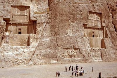 May 9, 2019 Naqsh-e Rustam: The Incredible Tombs and Rockface Reliefs of the Sassanian Kings
 June 20, 2019 Zoroastrianism: The Oldest Monotheistic Faith is Now on the Verge of Extinction
 December 10, 2019 Loung Pordaeng: The Bespectacled Monk Mummy of Wat Khunaram
 April 13, 2020 The Deviant Spiritualism of an Indian Tribe That Practices Cannibalism And Necrophilia
The post The Nasir al-Mulk Mosque Hosts a Kaleidoscopic Play of Lights Reflecting the Morning Sun appeared first on .
]]>The post Tree of 40 Fruits: A Patchwork Canopy of Myriad Fruits appeared first on .
]]>
Tree of 40 Fruit at Syracuse University campus, United States. (Sam Van Aken/Wikimedia Commons)
A single tree bearing 40 different varieties of fruits sounds like something out of science fiction, or maybe a fantasy novel. Sam Van Aken, an art professor with a penchant for agricultural experiments, has transformed this seemingly “mythical” concept into a tangible reality.
What is a Tree of 40 Fruit?
The Tree of 40 Fruit embodies an entire orchard’s produce under a single canopy. The tree bears forty different types of stone fruits- including popular varieties like cherries, apricots, nectarines. A majority, however, comprises ‘antique’ species that seem to fade from existence, if not already extinct. While in summer the tree is ripe with a plethora of unique fruits, it is truly a sight to behold in spring with its branches blooming into myriad pastel blossoms.

The various fruits of the “Tree of 40 fruit”. (Sam Van Aken/Wikimedia Commons)
What inspired the creation of the Tree of 40 Fruit?
Sam Van Aken envisioned the Tree of 40 Fruit to be a piece of natural art. A sculptor himself, Aken deemed the Tree to be like a sculpture that would evolve itself over time if the transformation based on his grafting process was optimally controlled. The Tree of 40 Fruit was conceptualized by Aken as a conservation project. An orchard renowned for producing various native American and heirloom stone fruits on the verge of existence at the New York State Agricultural Experiment Station was shutting down due to lack of funding when Aken stepped in. He bought the orchard in 2008 and thus began the journey towards creating the Tree of 40 Fruit.
Read more: Meet the Rainbow Colour Eucalyptus Tree—Native to the Philippines, Indonesia and Papua New Guinea
How was the tree created?
Aken conducted his project of creating the Tree of 40 Fruit in the orchard he bought, experimenting with approximately 250 varieties of stone fruit trees he had at his disposal. He used ‘chip grafting’ which entails a small slice of a tree (including a bud) on a single pre-existing tree. Aken had already prepared the tree for this process by conducting a few graftings onto the root system. Once the parent tree had reached the age of two, he proceeded to chip-grafting various species onto the tree branches. Once the vascular systems of the plants fuse, they grow as though a single tree. Limiting himself to exclusively stone fruit trees ensured that the grafts Aken was working with were compatible with each other. In addition, Aken had carefully studied the blooming patterns and fruiting timeline of each species and ensured they worked in cohesion after the grafting process. His meticulous experimentation and research finally culminated after five years when Aken had his Tree of 40 Fruit ready.

Fruits harvested from the “Tree of 40 fruit”. (Sam Van Aken/Wikimedia Commons)
How many such trees exist?
While the first was a massive success, Aken did not limit himself to a single Tree of 40 Fruit. He went on to create 21 other such trees, seven of which are in New York. The rest are distributed across the country in parks or in private collections.
Significance of the Trees of 40 Fruit
“They all maintain their own genetic variety”, Aken says about the various species housed within a single Tree of 40 Fruit. This helps preserve numerous ‘heirloom’ species of stone fruits on the verge of extinction due to not being commercially viable. A conservation effort, Aken has helped preserve the various species in all their uniqueness- whether it is in their appearance or taste and aroma. Though the trees are a spectacle bound to draw the awe of onlookers, Aken has made it clear that none of the fruits from the Trees of 40 Fruit are for commercial production and his art is an attempt at preservation.
For more unusual stories & intriguing news follow STSTW Media on Instagram and Facebook. Also, join our live chat discussion on Twitter.
Do you have a story/photo for us?
We welcome your contribution at [email protected]. Please include your name, city, state, and country.
Fact Analysis:
STSTW Media strives to deliver accurate information through careful research. However, things can go wrong. If you find the above article inaccurate or biased, please let us know at [email protected].
RELATED
 August 30, 2018 Saving the Kakapo – The World’s Strangest Parrot
 April 8, 2019 The Manchineel Tree: One of the Most Toxic and Dangerous Tree in the World
 March 6, 2019 The Silky Anteater: The Nocturnal Dweller of the Tropical Rainforests
 May 16, 2020 Xylaria Polymorpha: A Macabre Mushroom that Resembles a Dead Man’s Fingers
The post Tree of 40 Fruits: A Patchwork Canopy of Myriad Fruits appeared first on .
]]>The post In the Early Days Samsung Sold Dried Fish & Noodles. Five Companies That Reinvented Themselves appeared first on .
]]>NOKIA

Nokia silk toilet papers. (Andrei!/Flickr)
This popular cell-phone company was a household name in the early 2000s. Though the Nokia Group now manufactures networking gear and software, the company has had a lucrative past that extends beyond the telecom industry. First established as a southern Finland pulp mill in 1865, Nokia had dabbled in most upcoming industries such as electrical power generation and telephones, till they finally settled on the telecom industry in the 1980s.

Nokia mobile phones from the 2000s. (Santeri Viinamäki/Wikimedia Commons)
Through the course of the company’s evolution over 155 years, it has sold everything from toilet paper to car tyres. The Nokia Corporation was reborn in 1967 after Nokia, Kaapelitehdas and Finnish Rubber Works merge to focus on the paper, electronics, rubber, and cable markets together. This gave them a huge scope of operation and in their heydays, Nokia churned out everything from rubber footwear, tyres and toilet paper, to televisions, cables, computers, military equipment, and phones.
NINTENDO
Nintendo Co. Ltd. is one of the most popular video game companies in the world. This Japanese enterprise has made some of the most iconic consoles, such as the GameBoy, Nintendo DS, and Wii, and phenomenal video game franchises including The Legend of Zelda, Animal Crossing, and of course Pokémon, Yet their origin was quite different. This 130-year-old company was set up by Fusajiro Yamauchi as Nintendo Koppai on September 23, 1889.

Nintendo’s first headquarters in Kyoto, Japan in 1889. (株式会社灰孝本店 許諾/Wikimedia Commons)
At its inception, Nintendo sold hand-painted gaming cards called Hanafuda, which became their claim to fame. These cards became a rage through Japan and everyone used them, right from children to the Yakuza (notorious gangsters) and gambling dens.

Hanafuda. (Japanexperterna.se/Wikimedia Commons)
Nintendo’s business boomed owing to their niche playing cards, and they decided to capitalise on this and make plastic-coated cards with Disney characters. This move went in their favour as Nintendo went on to become the biggest playing-card seller in Japan. Over the years, the company has expanded to explore many ventures, including instant ramen noodles and taxi service, before making the gaming industry their sole focus.
Read more: Saudi Aramco, the World’s Most Profitable Company
SONY
Sony is a Japanese-origin multinational brand that is one of the foremost in the consumer and professional electronics industry. This 75-year-old company, set up as Tokyo Tsushin Kenkyujo (Totsuken) by Masaru Ibuka in 1945, began on a different note. A radio repair company in the wake of World War II, Totsuken was not doing very well. Their sudden experiment to make an electric rice cooker was a massive failure even at a testing stage and was never unveiled to the public.

Sony rice cooker. (Cjchunt/Wikimedia Commons)
Tokyo Tsushin Kogyo K.K. or Totsuko, was an attempt to give the failing company a new lease of life through a merger. Totsuko’s target market was the telecommunications industry, and they put great emphasis on research and development. The first official product of the company was a Power Megaphone, and they finally gained momentum with the manufacture of the ‘Soni-Tape’ in 1950, which was Japan’s first recording tape of this kind. Totsuko finally became ‘Sony’ in 1955, when the company explored the international market following the success of many electronic innovations over the years.
IBM
IBM, or International Business Machines Corporation, is one of the largest technology and consulting companies in the world. A multinational company headquartered in the US, IBM finds its roots back to a company founded in 1911 called the Computing-Tabulating-Recording Company (C-T-R), which itself was a merger of three smaller companies.

IBM 1920’s sale catalogue showing clocks, scales and tabulating equipment. (CTR/Wikimedia Commons)
IBM is renowned for being global changemakers with its innovative technology solutions, and it all began with a plethora of machines by C-T-R that focused on collecting, quantifying, and analyzing information. One of C-T-R’s most popular products was a tabulating machine that was used to conduct a population census in multiple countries, including Canada and Russia. Over the course of its evolution through the initial years, C-T-R experimented with a lot of different products, some successful and some sub-par, ranging from meat choppers and bacon slicers to coffee mills and commercial computing scales.
SAMSUNG
Samsung is a South-Korean origin global pioneer in the electronics industry. While they do not have their eggs in one basket, as innovators in the electronics, defence, construction, heavy industry, insurance, and even entertainment industries, this is not a new phenomenon for the business giant.

Samsung trading company in the 1930s. (Wikimedia Commons)
When Samsung was founded by Lee Byung-Chul in 1938, it began as a trading company and grocery store that sold a variety of products- ranging from vegetables and dried fish to their own brand of noodles. After the Korean War, the company built a sugar refinery and the largest woollen mill in the country. Samsung soon diversified into textiles, insurance and retail in quick succession. Today, the company is responsible for producing one-fifth of the gross export from South Korea.
For more unusual stories & intriguing news follow STSTW Media on Instagram and Facebook. Also, join our live chat discussion on Twitter.
Do you have a story/photo for us?
We welcome your contribution at [email protected]. Please include your name, city, state, and country.
Fact Analysis:
STSTW Media strives to deliver accurate information through careful research. However, things can go wrong. If you find the above article inaccurate or biased, please let us know at [email protected].
RELATED
 December 6, 2019 Ross Ulbricht: The Creator of the Booming Dark Net E-Commerce Network
 February 28, 2019 Under the Sea: Do Fishes Dream?
 March 9, 2020 Newly Released Book The Panama Papers Unveil the Indian Side of the Biggest Global Corruption Scandal
 February 26, 2020 Newly Released “From Oberoi to Oyo” – A Close Look into the Revolution of the Indian Hospitality Industry
The post In the Early Days Samsung Sold Dried Fish & Noodles. Five Companies That Reinvented Themselves appeared first on .
]]>The post The Clermont-Ferrand Cathedral: A Beautiful Gothic Structure Made of Black Lava Stone appeared first on .
]]>
Clermont-Ferrand Cathedral. (Fabien1309/Wikimedia Commons)
The Clermont-Ferrand Cathedral, or the Cathédrale Notre-Dame-de-l’Assomption, looks like something out of a dark fairytale. The dark looming structure of this Gothic Cathedral, with its windows ablaze from the stunning medieval stained glass, stands atop a hill and cuts an iconic visage. Built through the 13th and 14th centuries, the Clermont-Ferrand Cathedral is the French National Monument and the seat of the Archbishops of Clermont.
Location
The Clermont-Ferrand Cathedral is located in the town of Clermont-Ferrand in the Auvergne, which is in the south-central region of France. Situated right at the heart of France’s volcanic region, the town of Clermont-Ferrand is surrounded by a chain of dormant volcanoes that is the largest in Europe.

At length it is in known as Cathedral of Our Lady of the Assumption of Clermont-Ferrand. (Fabien1309/Wikimedia Commons)
Built from black lava rocks
The Clermont-Ferrand Cathedral is built entirely using black lava stone and in the Gothic style of architecture. The Cathedral’s twin spires rise to an astounding height of 96.1 meters and overlook the largest dormant volcano of the surrounding range, the Puy-de-Dôme.
The ginormous steeples are perhaps the most dominating feature of not only the cathedral, but the entire town. The Clermont-Ferrand Cathedral also houses a 10th Century crypt, which is the oldest section of the cathedral. Besides the stunning medieval glass painting on the windows that depict the saints and their rise to martyrdom, the complex contains a vast number of Gothic wall paintings which are some best preserved medieval frescoes.

The main entrance of Clermont-Ferrand Cathedral. (Fabien1309/Wikimedia Commons)

Side view of the cathedral. (jean-louis Zimmermann/Flickr)
The nave of the Cathedral is surrounded by columns made of the same black lava stone, lending a sombre atmosphere within. The light through the stained windows pouring into the black cathedral interiors creates a mesmerising chiaroscuro effect. The black stone ceiling soars to 30 metres. An intricate 16th century clock housed within adds another point of interest. The clock chimes as the automatons of the two Roman gods Mars and Faunus beat the head of Saturn, the elderly Lord of Time.
The exterior facade of the Clermont-Ferrand Cathedral displays the quintessential Gargoyles which are integral to cathedral architecture. These Gargoyles help with drainage by pouring out accumulated water through their gaping mouths in case of heavy rain. Next to the Cathedral complex lies the Place de la Victoire, which exhibits the statue of Pope Urban II.
A long story
The Clermont-Ferrand Cathedral, interestingly, is not the only cathedral to have stood on the spot. The building was in fact built atop the remnants of two previous structures. The crypt housed within the Cathedral, as well as various other vestiges of the previous churches, has been seamlessly incorporated into the foundation and structure of the Cathedral. Constructions for the Clermont-Ferrand Cathedral began in 1248, but it was not officially completed until 1908. The Hundred Years’ War (1337-1453) and the French Revolution (1789-1799), and both their far-reaching repercussions hindered the construction process. The completion process could only begin as late as 1866.

The crypt inside Clermont-Ferrand Cathedral was discovered in 1885. (L.Falchero/Le Duc)
The construction of the existent facade of the Clermont-Ferrand Cathedral started in 1246, under the episcopacy of Bishop Hugues de la Tour. A friend of the contemporary monarch King Louis IX, Bishop Hagues was a man of eminence and affluence. The prominent Gothic style of cathedrals from northern France inspired the structure of the Cathedral. Designed by the architect Jean Deschamps, the impact of the cathedrals at Beauvais and Amiens are significant in the designs of the Clermont-Ferrand. Deschamps’ plans did not involve any bracing arches, and the windows were not to take up all the space between the supports. The ribs of the structure drove into the arches, while the flying buttresses projected into the aisles of the Cathedral’s nave. The pillars of the choir-rotunda ingeniously created an elliptical so the light could filter in through the apsidal windows into the sanctuary. Both the choir and the transept of the Clermont-Ferrand Cathedral were completed under the Deschamps’ supervision before the architect finally passed away in 1295.

The interior of Clermont-Ferrand Cathedral. (jean-louis Zimmermann/Flickr)
While its construction was deferred, the Cathedral complex was spared extensive damage during the French Revolution owing to the pleas of a very diplomatic clergyman, Benedictine Verdier-Latour, who argued that the building could serve the people as a gathering spot. He swayed public opinion and the basic structure of the Clermont-Ferrand Cathedral stood the test of time, although its altar, choir, rood screen, and furniture faced the ravages of the Revolution.
For more unusual stories & intriguing news follow STSTW Media on Instagram and Facebook. Also, join our live chat discussion on Twitter.
Do you have a story/photo for us?
We welcome your contribution at [email protected]. Please include your name, city, state, and country.
Fact Analysis:
STSTW Media strives to deliver accurate information through careful research. However, things can go wrong. If you find the above article inaccurate or biased, please let us know at [email protected].
RELATED
 September 24, 2019 The Mahabat Maqbara and the Extraordinary Tomb of Bahar-ud-din Bhar
 November 22, 2018 33 Thomas Street: Windowless Skyscraper in the Midst of Bustling New York City
 December 26, 2018 Moscow State University: An Architectural Marvel
 August 20, 2019 Reynisfjara: The Black Sand Beach that Looks Straight out of a Gothic Novel
The post The Clermont-Ferrand Cathedral: A Beautiful Gothic Structure Made of Black Lava Stone appeared first on .
]]>The post Bartini Beriev VVA-14: The Cold War Scramble for Arms Gave Birth to an Amphibian Aircraft in Russia appeared first on .
]]>
Bartini Beriev VVA-14 in dilapidated condition. (Alex Beltyukov / Wikimedia Commons)
It takes little to almost nothing for us to take a trip back to the horrific time of the World Wars. Almost all inventions that are used more as a necessity today, either witnessed their inception or their development during the Wars, especially the Second World War. Following the disastrous Second World War, palpating tension between the United States of America and the Soviet Union gave birth to the Cold War. Under these circumstances, the 1970s saw the development of the Bartini Beriev VVA – 14, an in-ground aircraft, created by the Soviet Union.
As President Harry Truman had said in 1945, “We have to get tough with the Russians. They don’t know how to behave. They are like bulls in a China shop…We have got to teach them how to behave.”
The tension between the Soviet Union and the United States of America was a steady reverberating one. This arms race was bringing the world to the brink of mutual destruction for once and for all. The Bartini Beriev VVA-14 was quite an innovation. It had quite a few remarkable features and its capabilities, at the time, seemed endless.
The name says it all
Robert Bartini, the man behind this aircraft, was of Italian origin. The Fascist Revolution in Italy resulted in his immigration to the Soviet Union, to provide his expertise in the field of aviation.
A graduate of Milan Polytechnic Institute and trained in a Roman pilot school, Bartini practiced as an aviation engineer for several projects over the years. He gave birth to the idea of an anti-submarine aircraft in the 1960s. A collaboration with Beriev Design Bureau in the year 1972 finally produced the Bartini Beriev VVA – 14 prototype. The same year witnessed its first flight but it did not reach its full potential.

Bartini Beriev VVA-14. (Aleksander Markin. Александр Маркин / Flickr)
While working on the development of the aircraft, it was decided that the project would reach its completion in three carefully planned and executed phases. The initial phase, the VVA – 14M1, was orchestrated mainly to test and analyse the aerodynamic technology with rigid pontoons. These pontoons were soon replaced with inflatable ones that were attached to the ends of the central wings sections.
The following phase was consecutively named VVA – 14M2. It had been elevated a little higher by adding special advanced features to it. It was now capable of blasting through two engines into the cavity under its wings. These provided the aircraft with a much stronger lift than what was initially constructed. The aircraft now had vertical take-off capabilities, aided by batteries, which could generate enough power to lift the engines.
The final phase of development was quite naturally given the name VVA – 14M3. This was an aircraft that was functionally tested for vertical takeoff capabilities. It was now properly equipped with anti-submarine warfare, magnetic anomaly detection called BOR – 1 MAD and an array of modern equipment.
An aviation breakthrough
One of the most prominent features of the Bartini Beriev VVA – 14 was its ability to take off from water and fly at very high speed over large distances. While high altitude was a prime factor, it was also very important that the aircraft could skilfully fly at a low height, just above the sea surface and while using ground effect.
This project required extensive research. The first test run of the Bartini Beriev VVA-14 was incomplete, but it saw its completion in 1974. By then the inflatable pontoons were installed, thus permitting flotation and water test.

Bartini Beriev VVA-14 front view. (Mike1979 Russia / Wikimedia Commons)
A lot of research and failed tests later, the aircraft was proved to be a grand success, with a hundred and seven trips and a hundred three hours of flight time in its honour. The ultimate aim of the aircraft was to destroy the United States Navy Polaris missile submarines. Amazingly, a three persons’ crew was more than enough for a successful operation.
Amphibious: Cold-blooded beast of steel that functions over water as well
The most unique aspect of this aircraft is its structure. The Bartini Beriev VVA-14 is quite commonly referred to as the “amphibious” aircraft as well. The aircraft’s ability to function over water gives it a few features that might be called ‘amphibian-like’. Its ‘deadly’ nature also lent itself to a pun around the cold-blooded trait of amphibians.
The plane is built with an all-around metal frame that contains a few prominent and characteristic features. It contains a fuselage, central wing, sections with floats, torsion-box central wing, removable wing portions, tail, and a cruising engine’s nacelles over the fuselage.
The side sections of the plane essentially exist to fix the horizontal and vertical tail. The removable wing portions have slats, slotted flaps and ailerons, while the tail came with elevators and rudders. Aerodynamic controls governed the aeroplane above the evolution speed. However, jet vanes were used during vertical takeoff and landing.
History of the Bartini Beriev VVA-14 through the wars of the time
However, this enterprise could not graduate much further beyond the prototype and testing stage, resulting in two remarkable functioning models only. Robert Bartini, whose brainchild was this aircraft, suddenly passed away taking with him, the slow gradual progress of this project as well.
The primary aspect of the aircraft was its “wing – in – ground – effect” to travel with several very useful features. It is quite unfortunate that the aeroplane was never allowed to ripe to its fruition. Failed tests after Bartini’s death drained the Soviets of their motivation, thus, leading to the eventual cancellation of the project. The remaining prototype of the Bartini Beriev VVA-14 is currently installed in the Russian Airforce Museum in Monino, since 1987. Although, it is a significant part of history that remains on display, its dismantled state is quite a sad sight to behold. Nevertheless, history on display is always exciting.
Enjoyed this article? Also, check out “Hughes H-4 Hercules | The Largest Flying Boat That Flew for Only 26 Seconds“.
For more unusual stories & intriguing news follow STSTW Media on Instagram and Facebook. Also, join our live chat discussion on Twitter.
Do you have a story/photo for us?
We welcome your contribution at [email protected]. Please include your name, city, state, and country.
Fact Analysis:
STSTW Media strives to deliver accurate information through careful research. However, things can go wrong. If you find the above article inaccurate or biased, please let us know at [email protected].
RELATED
 October 24, 2019 Why Were the Apollo 11 Astronauts Quarantined after Returning from the Moon?
 March 17, 2019 Duga Radar: Unravelling of the Mystery Behind the Soviet Woodpecker
 June 8, 2020 The Secret US Mission to Blow Up the Moon- Project A119
 May 9, 2018 The Antonov An-225: The Longest and the Heaviest Aircraft Ever Built
The post Bartini Beriev VVA-14: The Cold War Scramble for Arms Gave Birth to an Amphibian Aircraft in Russia appeared first on .
]]>The post Li Ching-Yuen: An Extraordinary Lifespan of 256 Years, or A Hoax? appeared first on .
]]>An extraordinary life
Li Ching-Yuen was extremely skilful and had mastered Qigong, a Chinese art of breath-control and exercise similar to Tai Chi. He spent most of his life in the mountains and was born in Wanxian Sichuan, where he also breathed his last.
It is believed that Li had picked up advanced reading at a very young age, and was extremely well-educated. By the age of ten, he had travelled to several parts of Asia, including Vietnam, Gansu, Tibet, Shanxi, Manchuria, and Thailand, to gather herbs. He went on to be an acclaimed herbalist, and spent a century gathering and selling herbs. He traded in several essential herbs in Oriental medicine, such as wild ginseng, goji berry, lingzhi, gotu kola, he shou wu, and other Chinese herbs. His own diet consisted primarily of such herbs and rice wine.
Read more: ‘Ape Woman’ Julia Pastrana: The Sad and Short Life of the Ugliest Woman in the World
In 1749 when Li was around 71 years of age, he supposedly relocated to Kai Xian and joined the army under the provincial Commander- in- Chief Yeuh Jong Chyi. He served as a teacher of martial arts and as a tactical advisor in the army.
In 1926, the Chinese Warlord Wu Peifu invited Li to his residence in Beijing, to know his secret of long life. According to General Yang Sen, Li’s visit to Beijing coincides with the time Li was teaching Beijing University’s Meditation Society. Here, he was invited by the famous author and meditation master, Yin Shi Zi.
In 1927, General Yang Sen of the National Revolutionary Army, invited Li to his residence situated in Wan Xian, Sichuan, where one of Li’s earliest known photographs was taken.

Photograph of Li Ching-Yuen taken in 1927. (Wikimedia Commons)
Li is believed to have produced approximately 180 descendants and had 24 wives in his lifetime. When Li died of natural causes on 6th May 1933, in Kai Xian, Sichuan, China, his twenty-fourth wife was only 60 years old.
General Yang Sen’s account of Li Ching-Yuen
After Li Ching-Yuen’s death, General Yang Sen wrote a report about him titled ‘A Factual Account of the 250 Year-Old Good-Luck Man’ (一个250岁长寿老人的真实记载). In his report, the General outlines the probable timeline of Li’s lifespan. In his report, he describes Li as “He has good eyesight and a brisk stride; Li stands seven feet tall, has very long fingernails, and a ruddy complexion.”
According to the General, Li served as a tactical and a topography advisor in the army of General Yu Zhongqi at the age of 51 years. And he retired from his military career at 71 and went to back to his profession as a herbalist, gathering herbs in the Snow Mountain in Sichuan province.
Read more: Pasqual Pinon: The Aberration of Multiple Heads
The secret of a long life
Wu Chung-Chieh, who was a professor at the Chengdu University, had found documents which affirmed that Li had been born in 1677. Owing to his exemplary service in the army, when Li turned 100 years old, the Imperial Government sent him a document congratulating him on his birthday. This was done for Li’s 150th and 200th birthdays as well. According to an article in The New York Times in 1930, Wu found records of the Imperial Chinese Government wishing Li on the latter two of these events.
One of Li’s disciples, Da Liu, a Taijiquan Master recalled Li Ching-Yuen had encountered a 500-year-old hermit in the mountains when he was himself 130 years of age. The hermit taught Li several things, including Baguazhang and Qigong, along with proper breathing instructions, as well as recommendations for an ideal longevity-enhancing diet to be followed. According to Da Liu, Li’s advanced lifespan was because “he performed the exercises every day – regularly, correctly, and with sincerity – for 120 years”. Another one of Li’s pupils said that according to Li, the secret to a long life was to “keep a quiet heart, sit like a tortoise, walk sprightly like a pigeon and sleep like a dog.” An article in The Evening Independent mentioned that Li had apparently found a magical herb when he was in the Yunan Mountains that prevented him from going old.
Li Ching-Yuen’s longevity: is it a Hoax?
However, gerontologists have dismissed these claims owing to the fact that no official documents have been found that would verify Li’s claims to such a long life. Even though there is huge confusion regarding the year of his birth, it is highly unlikely that he could have lived for so long.
The longest verified age of a person has been recorded as that of Jeanne Calment, a supercentenarian, born in February 1875, in Arles, France. Calment had lived for 122 years and 164 days when she finally passed away on 4th August 1997, at Arles. According to records, Jeanne Calment outlived both her daughter, Yvonne, as well as her grandson.
Another recorded supercentenarian is Jiroemon Kimura, a Japanese man who was born in April 1897. He died in June 2013 and was 116 years and 54 days old. Kane Tanaka, yet another Japanese man, is a supercentenarian who is still alive at the age of 117 and was born in 1903.
Although it is possible that Li Ching-Yuen lived a long life—perhaps longer than the longest recorded person. However, it is unlikely that he made it anywhere close to 256.
For more unusual stories & intriguing news follow STSTW Media on Instagram and Facebook. Also, join our live chat discussion on Twitter.
Do you have a story/photo for us?
We welcome your contribution at [email protected]. Please include your name, city, state, and country.
Fact Analysis:
STSTW Media strives to deliver accurate information through careful research. However, things can go wrong. If you find the above article inaccurate or biased, please let us know at [email protected].
RELATED
 November 8, 2019 Tim Berners-Lee, the Inventor of World Wide Web: A Leader in the Face of a Revolution
 July 10, 2018 Sky Burial: The Ritual of Feeding the Dead to the Vultures
 August 10, 2018 Balut: A Filipino Delicacy Not Many Have the Stomach to Digest
 October 18, 2019 Frederick Law Olmsted – Father of American Landscape Architecture
The post Li Ching-Yuen: An Extraordinary Lifespan of 256 Years, or A Hoax? appeared first on .
]]>The post Mehran Karimi Nasseri’s 18 Years Stay at the Airport appeared first on .
]]>
Mehran Karimi Nasseri in 2005. (Saint Martin / Wikimedia Commons)
A man by the name of Mehran Karimi Nasseri, remained an accidental resident of Terminal 1 at the Charles De Gaulle International Airport between August 26, 1988 to July 2006. Nasseri’s actual intention was to head out to the United Kingdom. However, a sad mix of strange refugee laws, and the absence of documentation, left the Iranian displaced at an airport terminal for a very long time. Although Nasseri claimed to be Iranian, he also claimed that he had been exiled from Iran, having lost his Iranian citizenship over a difference in political views. It is because of this claim that he had asked for political asylum from Iran.
It is difficult to understand the advent of his story because Nasseri himself asserted different versions through time. What is undeniably obvious, however, is that for around 18 years, despite having his own assets close by, Mehran Karimi Nasseri lived in the terminal of the Paris airport.
18 years at the Parisian airport terminal
There was nothing special about Mehran Karimi Nasseri’s life before his accidental stay at the Parisian Airport. Born to a middle-class family in 1943 Iran, he had a truly average youth. At the age of 30, he travelled to the United Kingdom to complete his studies at the University of Bradford, which was roughly a 3-year stay.
Nasseri’s mother revealed to him that she was actually not his biological mother and that his biological mother was a Scottish Nurse who had an illicit affair with his father. This made him believe that he was actually a citizen of the United Kingdom and that he might as well apply for British citizenship. While this seemed easy and right out of a movie, it proved to be rather disastrous.
In 1988, Nasseri travelled to London en route from Paris. It is at this point, that Nasseri’s story gets dubious. He claimed that his required documents were in a briefcase that had been stolen when he was on a train in Paris. Consequently, when he reached Heathrow Airport in London, Passport Control deported him back to France due to his lack of documentation. He did not have a passport or a Visa, and according to the law, he was not permitted to be in the UK. On being deported to France, he encountered more trouble at Charles De Gaulle International Airport.
Since he did not have any documentation on him, he was not allowed to leave Charles De Gaulle Airport either. With such a strange event occurring, Nasseri and the people around him assumed that his stay would be extended to a few weeks at the most. Little did he know, he would end up spending 18 years of his life in that airport terminal.
He spent the next 18 years making the airport his home and stayed on a red bench that he made his personal spot. He spent his time reading books and newspapers around the various shops at the terminal. He had his luggage tucked beside him all the time and the airport provided him with basic amenities like bathroom, showers and even laundry. He lived by spending his life savings and managed to survive just fine because whatever he needed was at his disposal and always just a step away.

Mehran Karimi Nasseri in the terminal. (Docpi / Wikimedia Commons)
The terminal
After a few years passed by, a company called Dreamworks Animations made a movie about his tragic story and offered him a payroll of 250,000 dollars. The movie was named “The Terminal” which was directed by Steven Spielberg, and elicited a great response from the audience as well as critics. The movie starred Tom Hanks, Catherine Zeta-Jones, and Stanley Tucci.
Aftermath
While all seemed to work out fine, Belgium claimed to have given Nasseri citizenship 7 years into his stay at the terminal, and France had granted him a residence permit as well. Belgian law states that a refugee who left the country after being accepted could not return, thus Nasseri ended up blacklisted from Belgium. The offers from France and Belgium were refuted by him, claiming that the documents were fake and that he had been granted citizenship by the United Kingdom under the name Sir Alfred Mehran in 1981.
Nasseri’s nationality was listed as Iranian under the new papers he was assigned, which was not necessarily the only reason he refused to accept the helping hand from the other nations. Nasseri insisted and hoped that he could head back to the United Kingdom. Not only did this surprise his lawyer Christian Bourguet; a human rights lawyer, who stayed by his side for 10 years, it also surprised people around the world as to why he did not get up and leave. It would have been practical and the best alternative to staying at an airport. People naturally assumed that he had become delusional and lost his mind. Journalists from all over the world began pouring in and wanted to take interviews of the famed Nasseri, resident of Terminal 1, Charles De Gaulle Airport. Perhaps the theory about Nasseri’s delusions was somewhat true, considering altered versions of the story were told by Nasseri himself. One of the most mind boggling alterations was when he claimed to be Swedish, and also claimed that he had arrived there by a submarine.
Mehran Karimi Nasseri’s departure from terminal 1
His first departure from Charles De Gaulle Airport Terminal 1 in 2006 was not voluntary. He had fallen sick and had to be taken to the hospital because of an unknown ailment. His ailment was never disclosed to the press and he was kept for 6 months for recurring treatments. After his rather long stay at the hospital, he was moved to a hotel near the airport. This was the first time in 18 years that Nasseri had left the airport. Later in 2008, he was granted freedom by the Government of France succeeding which he stayed in the suburbs of Paris, still a homeless, and state-less, man. All the speculation would have been solved if only the thief who stole Nasseri’s passport would have been caught. Or did he truly arrive by a submarine? Perhaps we will never know for sure.
Enjoyed this article? Also, check out “Martin Laurello: The Astounding ‘Human Owl’ Who Could Turn His Head Around By 180 Degrees“.
For more unusual stories & intriguing news follow STSTW Media on Instagram and Facebook. Also, join our live chat discussion on Twitter.
Do you have a story for us?
We welcome your contribution at [email protected]. Please include your name, city, state, and country.
Fact Analysis:
STSTW Media strives to deliver accurate information through careful research. However, things can go wrong. If you find the above article inaccurate or biased, please let us know at [email protected].
RELATED
 September 22, 2019 Leonarda Cianciulli: The Ill-fated Correggio Killer who Made Soap and Cookies of Her Victims
 March 10, 2019 Barra Airport, Scotland: Where Planes Take Off and Land on a Beach
 March 12, 2020 The Quirky Palate and Gourmet Adventures of Charles Darwin
 February 17, 2019 The Catacombs of Paris: A City of the Dead Under the City of Love
The post Mehran Karimi Nasseri’s 18 Years Stay at the Airport appeared first on .
]]>The post Xylaria Polymorpha: A Macabre Mushroom that Resembles a Dead Man’s Fingers appeared first on .
]]>
Xylaria polymorpha, commonly known as dead man’s fingers. (Virginia Arboretum / Flickr)
Saprobic fungi grow on and derive its nutrients from dead or decaying plants and tree barks. One such saprobic fungus is the Xylaria Polymorpha that bears an uncanny resemblance to the fingers of a dead charred human and hence acquired the name Dead Man’s Fingers. Typically, a fungus has several stages of growth and ‘mushrooms’ are the reproductive stage of the Xylaria Polymorpha. At this stage, it grows crooked and is yellowish on the tips, much like decaying fingers.

Xylaria polymorpha during its early stage. (AJ Cann / Flickr)
Where can you come across one?
Britain, Ireland and many parts of North America are home to Xylaria polymorpha. The fungus is generally found on the forest floors near remains of dead trees like apple, maple, elm and beech. Several factors contribute to its growth, the most decisive being temperature and moisture. Spring provides optimal balance and temperature for its growth, resulting in big clusters of the fungus around dead tree stumps.

Xylaria Polymorpha growing on a dead tree. (Björn S… / Flickr)
The anatomy of a dead man’s fingers
During its lifespan, it keeps changing its size and colour, which is how it came to be named Xylaria polymorpha, meaning “many shapes”. As mentioned earlier, when young, it exhibits a pale bluish body colour along with a whitish tip. The coating of asexual spores gives its body a blue colour. After it gets a little mature, it attains a brownish-black colour with a coating of sexual, spore-producing, perithecia. It is during this stage that it resembles a dead man’s fingers, often during summer. And as it matures, it can grow up to a length of 14 cm and a thickness of roughly 5.5 cm.
The black coating donned by the mature fungi contains asci, which are essential to the production of the spores. This fungus belongs to the phylum Ascomycota, which is by far the largest section of the fungal kingdom. The spores of these fungi contain guttules—oil like drops and help in reproduction. Each ascus contains 8 spores. Interestingly, despite being a fungus, its texture is like that of wood and is hard.
Read more: Socotra Island of Yemen- The Most Alien-Looking Place on Earth
Why do they look so distinctive?
Wood is mainly composed of cellulose and lignin, with glucans acting as glue. The colours that are displayed by the Xylaria Polymporpha are because of rot fungi. White rot fungi consume or rather digest the lignin and white cellulose remains, hence resulting in the whitish tip during the pre-maturity stage. In the maturity and post-maturity stage, brown rot fungi digest the cellulose and only the brown lignin is remaining, due to which the brown and blackish colouration occurs as it continues to decay. It is precisely due to this appearance and the fact that Xylaria Polymorpha reaches out of the ground that it is called Dead Man’s Fingers. People who are not equipped with information about the fungi can easily mistake it for human fingers sticking out of the ground.
Similar species
There are three species of Xylaria that are so strikingly similar to Xylaria Polymorpha, that they could be wrongly identified and mistaken for Dead Man’s Fingers. Xylaria hypoxylon is a species that resembles the entire anatomy of the Xylaria Polymorpha, except that it is distinctly thinner. On the other hand, Xylaria Longiana is completely identical to Xylaria Polymorpha with the exception of it having smaller spores. There is no other structural difference between the two at all. The differences between some species are so subtle that they cannot be distinguished when we observe them with the naked eye. However, they can be easily segregated based on lab examination of samples of their cultures. Interestingly, this holds true only for the mature mushrooms. At a prematurity stage, the fungi are practically indiscernible even under a microscope.

Xylaria hypoxylon. (James Lindsey / Wikimedia Commons)
Similarities are also observed in the Cordycipitaceae family of mushrooms, but they are identified as parasites. Another group of similar mushrooms is known as Earth Tongue, but they do not form perithecia and are distinguishable from Xylaria Polymorpha on close observation.

Yellow earth tongue. (Bernard Spragg. NZ / Flickr)
Uses of Xylaria polymorpha
Although a lot of mushroom varieties are edible and find their way into various cuisines, the Xylaria polymorpha is inedible when it is mature and may have adverse effects on the human digestive system. There are, however, delicacies that are prepared with shavings of the Xylaria Polymorpha during its premature stage.
The Xylaria Polymorpha has found use in the indigenous Indian medical system of Ayurveda. The powdered fruiting body of the fungus is mixed with sugar and consumed by women after giving birth to promote lactation.
The fruiting body of the fungus is also the source of two polypropionates which have come to be known as xylarinic acids A and B. These acids have anti-fungal properties and helps combat against plant-pathogenic fungi.
Enjoyed this article? Also, check out “The Manchineel Tree: One of the Most Toxic and Dangerous Tree in the World“.
Do you have a story for us?
We welcome your contribution at [email protected]. Please include your name, city, state, and country.
Fact Analysis:
STSTW Media strives to deliver accurate information through careful research. However, things can go wrong. If you find the above article inaccurate or biased, please let us know at [email protected].
RELATED
 July 5, 2019 Rainbow Eucalyptus: A Stunning Demonstration of Nature’s Vibrant Art
- April 8, 2019 The Manchineel Tree: One of the Most Toxic and Dangerous Tree in the World
 June 19, 2020 Tree of 40 Fruits: A Patchwork Canopy of Myriad Fruits
- April 14, 2019 Fingal’s Cave: The Musical Geometry of Nature’s Domain
The post Xylaria Polymorpha: A Macabre Mushroom that Resembles a Dead Man’s Fingers appeared first on .
]]>The post Elephant Beach: The Dazzling Sandy Beach in Andaman and Nicobar Islands Perfect for an Exotic Vacation appeared first on .
]]>
Elephant Beach, Andaman and Nicobar Islands, India. (Senorhorst Jahnsen / Flickr)
Elephant Beach is one of the hottest spots on Havelock Island, in Andaman and Nicobar, India. The Elephant Beach is a public beach with bright coral reefs that spans up to a depth of one metre. It is one of the most popular beaches out there that attracts a ton of visitors every year. The sandy white beaches and clear blue-green water make for an ideal location for a variety of water sports. The region also houses mesmerising diverse marine creatures. Sea walking, swimming, snorkelling, kayaking, and bird-watching are some of the fun activities that the Elephant Beach offers its tourists.
Interestingly, the beach got its name as the elephants were the main means of transportation back in the day, and tourists arrived in that exotic manner.
Although there are no elephants to be seen on the island today, elephants are sometimes brought here to visit by a forest officer.
How to get to the Elephant Beach?
Elephant Beach is located very close to Havelock Island, takes about twenty minutes by boat from the docks. To reach Havelock Island, you must first reach Port Blair and then take a ferry boat to Havelock since it does not have an airport. The journey from Port Blair to Havelock Island on the ferry takes about one and a half hours, measuring to seventy kilometers. The journey from here to the Elephant beaches is the bat of an eyelid by boat.
You could also have an amazing therapeutic walk to the beach instead of riding a boat. The path is covered with lush green trees adding to one’s soothing and holistic experience. One can also use a public bus, hire a bike or take an auto to get to the Beach from Havelock today.
Spending a day amidst the white sands and sparkly water
Scuba diving is one of the most sought after activities here, a chance to live and experience the world underwater. When one has had enough of water, there are other beaches around the Elephant Beach to explore such as Kalapather Beach, Radhanagar Brach and Govindnagar Beach.
As much as the beach offers to feed one’s soul, feeding the body could prove to be a task owing to the lack of proper restaurants on the beach. There are a few shacks few and far in between, and small stalls for refreshments and some light snacks. However, though restaurants on Havelock island has a plethora of food options to devour. Tour agencies usually provide packages to tourists.
The last ferry from the beach leaves at around 3:30 pm and the Elephant Beach completely shut down at four ‘o clock. A carefully planned itinerary is essential to spend one whole afternoon to enjoy all the activities the beach has to offer.
When is the ideal time to visit the beach?
The Elephant Beach is blessed with tropical weather all year round. One can, as a result, drop by whenever in the mood for an exotic vacation by the sea. The ideal time to visit Elephant Beach, however, is sometime between November and February. During this time of the year, the sea remains absolutely calm and cool. To enjoy bright and sunny weather there, April and June are the months to visit.
Amenities available
Hospitals are not available on the beach. However, first aid kits are available all over the beach. If travelling through an agency, they will provide any emergency care need. Since the Andaman and Nicobar Islands are within the Indian Union Territory, most Indian networks work just fine. However, there could be a few signal issues as the beach is relatively isolated. Resorts are available in Havelock Island, which is just twenty minutes away from the Elephant Beach.
The cost of the boat ride is dependent on various service providers and the season but usually ranges between rupees 750 to 1250 Indian Rupees. It is crucial to keep in mind that the Elephant Beach is not open throughout the day. It is only open for day trips from around 7 am in the morning, and shuts down entirely by 4 pm.
Enjoyed this article? Also, check out “Barra Airport, Scotland: Where Planes Take Off and Land on a Beach“.
Fact Analysis:
STSTW Media strives to deliver accurate information through careful research. However, things can go wrong. If you find the above article inaccurate or biased, please let us know at [email protected].
RELATED
 July 6, 2019 Playa de Gulpiyuri: The Tiny Beach in the Principality of Asturias in Spain
 December 6, 2018 Cancun Underwater Museum: A Sunken Museum Dedicated to Conserving Marine Life
 May 26, 2019 Neptune Memorial Reef: An Eco-Friendly Underwater Graveyard Off the Florida Coast
 November 25, 2018 North Sentinel Island: Home to an Uncontacted, Hostile and Primitive Tribe
The post Elephant Beach: The Dazzling Sandy Beach in Andaman and Nicobar Islands Perfect for an Exotic Vacation appeared first on .
]]>The post An Interior Design Masterpiece That Bears Testimony to an Artist’s Strife for Perfection appeared first on .
]]>
The peacock room. (Smithsonian’s Freer and Sackler Galleries / Flickr)
Located in the Freer Gallery of Art in Washington DC, one can visit the Harmony in Blue and Gold: The Peacock Room (commonly referred asThe Peacock Room). Created by James McNeill Whistler and Thomas Jeckyll, The Peacock Room is considered to be one of the most decorative masterpieces. This room is considered to have one of the most richly decorated interiors and is one of the greatest surviving examples of the Anglo-Japanese style. Painted sometime around 1866-77, Whistler used a rich palette of blue-greens with white over-glazing, as well as a metallic gold leaf for the room.
What is ‘The Peacock Room’?
Owned by Frederick Richards Leyland, a British shipping magnate, The Peacock Room was originally designed as a dining room for Leyland’s townhouse located at Kensington, London. Leyland employed the services of the British architect, Richard Norman Shaw, to remodel and redecorate his home. Shaw assigned Thomas Jeckyll, another British architect, to remodel the dining room. Jeckyll specialized in the Anglo-Japanese style, and perceived the dining room as a ‘porcelain room’.
An aesthetic marvel
This room’s intended use was to display Leyland’s collection of exquisite blue-and-white Chinese porcelain, most of which belonged to the Qing dynasty of the Kangxi era. Jeckyll created spindled walnut shelves with very intricate latticework to hold these porcelain pieces on display.

Shelving in The Peacock Room. (Sarah Stierch / CC BY 4.0)
Jeckyll decorated the room with wall hangings from the 16th century of Cuir de Cordoue, which arrived in England as a part of the dowry belonging to Catherine of Aragon. The painted hangings symbolised her union with Henry VIII, and comprised of an open pomegranate and red Tudor roses. For centuries, the hangings could be found on the walls of a house in Norfolk, till Leyland bought them for £1,000.
To the north of the room, the expat artist Whistler’s painting hung, which was the focal point of the room. The subject of the famed painting was Christina Spartali, an Anglo-Greek beauty, whom every artist hoped to have as a muse in her lifetime. The painting is one of Whistler’s greatest works and is aptly titled “The Princess from the Land of Porcelain” while it enjoys its position of honour amidst Leyland’s porcelain collection.

The Princess from the Land of Porcelain by James Abbott McNeill Whistler. (National Endowment for the Humanities / Wikimedia Commons)
A Spontaneous Artistic Marvel

Portrait of Thomas Jeckyll. (Wikimedia Commons)
Jeckyll had nearly completed his work when he suddenly fell ill, and was forced to abandon the project. At the time, Whistler, who was working on the decorations for the entrance hall at Leyland’s house, said he could lend a hand in finishing the work at the dining room. Whistler was concerned that the red roses on the leather hangings were clashing with his painting of ‘The Princess’.
Whistler suggested a minor alteration to the room and wanted to retouch the leather with yellow paint, to which Leyland agreed. He also gave Whistler permission to decorate the wainscoting and the cornice with a “wave pattern” which was derived from Jeckyll’s design of the leaded glass door. After authorising Whistler to make these minor alterations to the dining room, Leyland left for Liverpool for some work.
Instead of making minor alterations like he said he would, Whistler painted the room in vivid colours of blue, green and gold. Whistler said,
“… I just painted on. I went on ―without design or sketch― it grew as I painted. And toward the end I reached such a point of perfection ―putting in every touch with such freedom― … And the harmony in blue and gold developing, you know, I forgot everything in my joy in it.”
Whistler wrote a letter to Leyland, in which he told him that he had a “gorgeous surprise” for him. Leyland was not only surprised, but also shocked at Whistler’s expenditure on embellishments which was approximately $200,000 more than what he expected. Leyland admonished Whistler, and the two had a huge argument until Leyland agreed to pay half the amount.

James McNeill Whistler. (The Metropolitan Museum of Art)
After this, Whistler did some more work on the room. He painted two peacocks on the wall opposite his painting of ‘The Princess’. In the mural, the two birds are seen facing each other, as if they are about to start fighting, and there are silver shillings strewn on the ground around them. Whistler named the mural ‘Art and Money; or, the Story of the Room’. He also went ahead and painted a leather wall which was very expensive, with a coat of Prussian blue paint.

The Peacock Room by Whistler. (Smithsonian’s Freer and Sackler Galleries / Flickr)
‘The Peacock Room’ changing hands
According to Lee Glazer, a curator of American art, after Whistler finished his work in 1877, Leyland threatened him with a horse-whipping if he was seen near the house ever again. However, Leyland kept Whistler’s work.

Frederick Richards Leyland. (John Parsons / Wikimedia Commons)
Leyland passed away in 1892, and a few years later, Charles Lang Freer, a railroad-car manufacturer who was a dedicated collector of Whistler’s works, acquired the ‘Peacock Room’, after having bought ‘The Princess’ earlier.
He had the ‘Peacock Room’ installed in his mansion in Detroit, which provided a setting for Freer’s own vast collection of Asian pottery and stoneware. In 1906, thirteen years prior to his death, Freer left his Whistler collection, including the ‘Peacock Room,’ to the Smithsonian.
“The Peacock Room’ today
After the death of Charles Lang Freer in 1919, the ‘Peacock Room’ was permanently installed in the Freer Gallery of Art in Washington DC, at the Smithsonian. The gallery was first opened to the public in 1923. In 2011, several curators spent months looking through archival photographs of the original installation of the ceramics in Leyland’s home, carrying forward research that a legacy such as this entails. They intended to reinstate it to the original aesthetics it might have presented back in Leyland’s dining room.

The Peacock Room, ca. 1890. (Linda Merrill / Wikimedia Commons)
In January 2016, the ‘Peacock Room’, along with some parts of the gallery, was closed for renovation. It was reopened to the public in the summer of 2017, with its walls lined with 177 quintessential Chinese porcelain pieces in an effort to have it resemble its glory in the 1870s.
Now, the shutters to the ‘Peacock Room’ are only opened once a month, which allows visitors to see the room through a very specific perspective, and makes the sighting that much more exclusive and close to how the artist envisioned it 200 years ago. When the shutters are opened, the room is flooded with natural light which highlights and accentuates the striking blue, green and gold tones in the room. The shutters of the Peacock Room are kept open exclusively on “the third Thursday of each month” from 12 noon to 5:30 pm.

Another side of the wall inside The Peacock Room. (Smithsonian)
Lee Glazer, the Curator of American Art at Smithsonian Institution said,
“The shadows and subtle colours proved a huge problem for the camera… Whistler would have been pleased.”
The wry remark points to the exclusivity of the experience of witnessing the ‘Peacock Room’ in person, and also at the subversive art of its great painter who lost himself in a passionate frenzy while completing room till it matched his ideals of perfection.
Enjoyed this article? Also, check out “The Fascinating ‘Amber Room’: The Fabled ‘Eighth Wonder’ of the World“.
Fact Analysis:
STSTW Media strives to deliver accurate information through careful research. However, things can go wrong. If you find the above article inaccurate or biased, please let us know at [email protected].
RELATED
 March 5, 2020 The Fascinating ‘Amber Room’: The Fabled ‘Eighth Wonder’ of the World
 January 9, 2019 Peacock Clock: An 18th Century Automaton Marvel
 June 26, 2019 The Concorde Jet: The Golden Run and Tragic Fall of the Legendary Aircraft
- November 22, 2018 33 Thomas Street: Windowless Skyscraper in the Midst of Bustling New York City
The post An Interior Design Masterpiece That Bears Testimony to an Artist’s Strife for Perfection appeared first on .
]]>The post Trump Gives Green-Light for Moon-Mining: How Does it Affect Outer Space Politics? appeared first on .
]]>
Artistic impression of a future moon colony. (NASA / SAIC / Pat Rawlings)
Amidst the deadly Coronavirus pandemic that has struck the entire world, Donald Trump, the President of the U.S., signed an executive order on April 6 that has a far-reaching impact on international relations and outer space politics. The treaty asserts that the U.S. does not think of space as a “global commons”. Therefore, it shall allow the country to mine lunar resources without requiring an international treaty to permit it. The White House believes that the water, ice and other lunar resources are available for the taking for the country of United States, which will help them in the establishment and consolidation of human presence on the moon.
Benefits of space mining
Sarah Cruddas, a space journalist, believes that mining the Moon would be rather beneficial and will aid humans to go further into space, like Mars, for instance. She also said that the Moon could operate as “an intergalactic petrol station” since it has resources essential for rocket fuel–hydrogen and oxygen. If there was a petrol station in space itself, it would mean that rockets could travel further in space as fuel limitations would no longer be a concern. Cruddas simplifies this idea with an analogy saying,
“It’s like not taking a kitchen sink when you go on holiday. We shouldn’t need to take everything with us when we go into space”.
According to Benjamin Sovacool, a professor of energy policy at the University of Sussex, humankind is aggressively blowing a hole through the resources at our disposal. Professor Sovacool believes that mining on the moon for resources could help in the building of things like electric cars, which would be beneficial in protecting the environment for the long haul. However, he also reiterates that space mining does not provide any short-term solutions in dealing with climate change.
The moon treaty of 1979
The ‘1979 Agreement Governing the Activities of States on the Moon and Other Celestial Bodies’, more commonly referred to as the ‘Moon Treaty of 1979’, stipulates that nations may not mine resources in outer space. However, several space-faring countries of the world including the U.S do not recognise the treaty. Countries that are already engaged in spaceflights or intend to do so have not adopted the Moon Treaty.
In fact, earlier in 1967 a treaty was signed called the ‘1967 Outer Space Treaty’, according to which, the use of lunar resources was allowed. Also, in 2015, Congress passed a law according to which American companies and citizens would be allowed to use moon and asteroid resources.
Though it was agreed that any nation can not claim the moon as their property, but currently it quite resembles maritime laws. Sarah Cruddas says, “If you go there, find it and mine it – it’s yours to keep.”Professor Sovacool explains that the typical argument for space settlement is that it will be our only escape since we will eventually ruin Earth’s ecosystem beyond repair. It is a viewpoint that asserts that the sole way to preserve a future for mankind is by seriously considering space settlement.
What does Trump’s executive order entail?
According to the executive order signed by President Trump, it is made clear that the U.S not only does not see space as a “global commons”, but it also makes things very official. According to administrative sources, the executive order was underway for nearly a year. The order also states that there are commercial partners taking part in an “innovative and sustainable program” which is being led by the U.S in order to “lead the return of humans to the Moon for long-term exploration and utilization.” The treaty states that a logical extension of this plan is to carry out human missions to Mars and other destinations in the long run.
In 2018, NASA, the space agency of the United States, had announced their plans to send astronauts to the moon by 2024, which had last been attempted in1972. NASA’s program for crewed space exploration, also known as ‘Artemis’ plans to send two of their astronauts to the moon by 2024 and aims to “establish a sustainable human presence on and around Earth’s nearest neighbour by 2028”. According to NASA officials, lunar resources, especially the water ice which is said to be found abundantly on the floors of the polar craters, is probably the doorway to the beginning of Artemis’ huge ambitions.
Scott Pace, who is the deputy assistant to Trump, along with being the Executive Secretary of the U.S National Space Council, said: “This executive order establishes U.S. policy toward the recovery and use of space resources, such as water and certain minerals, in order to encourage the commercial development of space.”
Dissenting views and a space race
The U.S has received many dissenting views, one of which belongs to the Russian space agency ‘Roscosmos’ which has condemned the executive order and labelled it colonialism. The deputy director-general of Roscosmos, Sergey Saviliev said, on the matter of international cooperation, “Attempts to expropriate outer space and aggressive plans to actually seize territories of other planets hardly set the countries (on course for) fruitful cooperation.” He proceeded to liken it to and remind us of the impact of British Colonialism specifically, and Colonialism as a concept, and how it has gone down in the annals of history.
However, despite criticising the U.S for its move about mining on the moon, Russia is not too far behind. They have expressed their plans to hopefully establish a permanent base on the moon sometime after 2025 in order to extract Helium.
China too has similar plans as Russia and the U.S with regard to asteroid mining and space explorations. In fact, there are talks that China and Russia may even team up in order to establish a “joint lunar and deep space data centre with hubs in both the countries”.
The ESA, or European Space Agency, has also expressed explicit interest in moon mining.
Trump’s space mission in a nutshell
Trump’s lunar development plans rely heavily on the cooperation between the private sectors and the U.S. Government. The signing of this latest executive order by Donald Trump will quite possibly not only strengthen the position of the U.S on an economical front but also in terms of their military strength. This aggressive encouragement for the activity of moon mining given by Trump may be considered a result of his presidential pursuits. He has consistently shown a very active interest in outer space over the years. He has endeavoured to lift regulations that hindered several mining projects which were given under the presidential rule of Barack Obama. In 2019, the United States became the only country to have an independent space force, cementing the nation’s position as a forerunner in the space race.
Enjoyed this article? Also, check out “A Glimpse into the Exciting World of Space Tourism“.
Fact Analysis:
STSTW Media strives to deliver accurate information through careful research. However, things can go wrong. If you find the above article inaccurate or biased, please let us know at [email protected].
RELATED
 May 21, 2020 Yes, we need a global investigation into Covid-19 origin, but not for scoring trivial political points
 April 30, 2019 A Glimpse into the Exciting World of Space Tourism
- October 24, 2019 Why Were the Apollo 11 Astronauts Quarantined after Returning from the Moon?
 October 21, 2018 Did Man Really Land on Moon? The Dilemma of Apollo 11’s Missing Tapes
The post Trump Gives Green-Light for Moon-Mining: How Does it Affect Outer Space Politics? appeared first on .
]]>The post Changing the Skull’s Shape to Adhere to the Community’s Beauty Standards appeared first on .
]]>
Artificial cranial deformation. (Wellcome Collection)
Artificial Cranial Deformation is a body alteration practise that has been a part of a variety of cultures since times immemorial. This practice refers to the intentional alteration or modification of the shape of an individual’s skull. What is interesting about the evolution of this practice is that the cultures it was prominent in were, in fact, all separated by geographical and chronological barriers. The desired shape – which may be conical, rounded or elongated – is brought about by distorting the normal growth of a child’s skull by application of force. In most cultures, the practice of head-binding begins Sat birth – for that is the time when the skull is most pliable. Artificial cranial deformation is very rare today – but it still occurs in places like the Pacific island nation of Vanuatu.
History of Artificial Cranial Deformation
Prehistoric times
Historians believe that artificial cranial deformation existed long before written or recorded history. One of the earliest examples of intentional cranial deformation dates back to the 9th Millennium BC. Remains of such modified skulls were found in the Shanidar Cave of Iraq. These remains were of the proto-Neolithic Homo sapiens component of the human race. In 400 BC, the great Greek physician Hippocrates wrote of the Macrocephali (long-heads), who were named for their head-binding practices. The Macrocephali were an ancient tribe of indigenous Africans or Indians. This is generally considered to be the earliest written record of artificial cranial deformation.
Old world

Deformed skull of a woman from the early 6th century Allemannic culture. (Anagoria / Wikimedia Commons)
The practice of head-binding was very much prevalent among important nomadic groups of the Old World. One of the most notable examples of this is amongst the Huns—nomads and warriors who frequently terrorised the Eastern Roman Empire. Written records and archaeological findings provide considerable evidence that the Huns practised artificial cranial deformation prolifically.
Another notable nomadic group that practised cranial deformation is the Alan group of people. The Alans were an Iranian nomadic demographic that was the ancestors of the Great Vandal Kingdom.
Age of antiquity
In the period of Late Antiquity, artificial cranial deformation was widely performed by a large number of East Germanic tribes. These tribes were descended from the Huns and included the Gepids, the Ostrogoths, the Heruli and the Burgundians. In some tribes like the Burgundians and the Thuringian, only women participated in the practice of head-binding. Evidence of artificial cranial deformation has not been found amongst West Germanic tribes.
The practice of head-binding and cranial deformation was brought to the Middle Eastern region in the 1st century AD by the tribes who created the Kushan Empire. These regions included Bactria and Sogdiana. These areas now comprise modern-day Afghanistan, Iraq and Kazakhstan.
The Americas
Artificial cranial deformation was widely practised by a large number of North and South American native tribes. The practice of head-binding was prevalent in the Mayan and Inca Civilization as well. In North America, the tribes living in the Chinookan and Choctaw regions also practised artificial cranial deformation. A group of Indians, called the Salish people, practised a form of head-binding that made their heads appear rounder. A subgroup of the Salish, the Bitterroot Salish, was referred to as “Flathead Indians”, just because they did not perform this specific custom. Nooksack Indians performed head-binding by strapping an infant’s head to their cradleboard.
Other areas
Artificial cranial deformation was also performed customarily by the Lucayan people of the Bahamas, amongst the indigenous tribes of the islands of Hawaii, Tahiti, Samoa and Paumotu. According to recently unearthed evidence, head-binding was also performed by the Aboriginal Australian Tribes and in the French district of Toulouse well into the 20th century.
The Mangbetu people of Africa too practised head-binding and they stood out to European explorers because of their elongated heads. The Mangbetu continued to practice artificial cranial deformation until the early 1900s when the custom began to die out.
This was mainly due to a medical myth, where parents would tightly bind the heads of newborn babies to prevent accidents. This practice of head-binding resulting in the Toulousain Deformation is called bandeau.

From the Scenes from every land by Grosvenor, Gilbert Hovey, 1875-1966, National Geographic Society (U.S.).
Methods and varieties
As discussed earlier, the practice of artificial cranial deformation usually started right after birth. At this stage, the skull is soft and almost malleable. It is continued regularly for the next few years until the desired shape has been achieved. Different methods of head-binding exist for achieving different skull shapes. The general practice is binding the infant’s head tightly with cloth or planks of wood to coax it into the rounded or elongated shape. Desired shapes include rounded, flattened, elongated and conical.

Artistic depiction of methods that were used by Maya peoples to shape a child’s head. (Fruitpunchline / Wikimedia Commons)
Why was this practised at all?
The motivations behind the practice of artificial cranial deformation have been studied and debated upon by historians all over the world. One of the most widely accepted theories is that it was practised to signify group affiliation or social status. An elongated skull or a rounded skull was considered aesthetically pleasing or desirable in certain cultures. To improve the social prospects of children, they were subjected to this procedure. In Mayan society, having an artificially deformed skull was a symbol of wealth, power and higher social status. In the North American native tribes, having a specifically shaped skull was a way of tribe affiliation or belonging. In France, head-binding was practised as a result of a pseudoscientific notion and medical myth.
Artificial cranial deformation is one of the most interesting phenomena that historians have been studying for a long time. It has been practised since prehistoric times by cultural groups that were widely separated and did not have any common link. However, all of them practised head-binding for the same basic reasons. Even today, in the islands of Vanuatu, individuals with distorted skulls are thought to be more intelligent and spiritually enlightened. Appearance has always been closely linked to social position and privilege and continues to be the same even today. The only difference is that modern-day civilizations have radically different standards of beauty and aesthetics.
Enjoyed this article? Also, check out “Trepanation: Unusual Medical Procedure of Drilling Hole in the Skull“.
Fact Analysis:
STSTW Media strives to deliver accurate information through careful research. However, things can go wrong. If you find the above article inaccurate or biased, please let us know at [email protected].
RELATED
- March 12, 2020 The Quirky Palate and Gourmet Adventures of Charles Darwin
 November 26, 2018 Penitentes – The Remarkable Ice Pillars of the Atacama Desert
 October 12, 2019 Trepanation: Unusual Medical Procedure of Drilling Hole in the Skull
 January 27, 2019 Madagascar Hissing Cockroach: An Unusual Wild Insect That Has Now Replaced Popular House Pets
The post Changing the Skull’s Shape to Adhere to the Community’s Beauty Standards appeared first on .
]]>The post The Ancient Multistory Underground Cities of Turkey Housed Thousands of People appeared first on .
]]>
Derinkuyu Underground City in Cappadocia, Turkey. (Nevit Dilmen / Wikimedia Commons)
Located in the Nevşehir Province, in the Derinkuyu district of Turkey, exists one of the oldest underground cities in the world. Extending to a depth of approximately 200 ft, this ancient underground city is believed to have housed upwards of 20,000 people, along with their domestic animals and food storage. Derinkuyu also happens to be one of the largest excavated underground cities in Turkey, amongst the several other complexes that were found underground scattered throughout Cappadocia.
Location
Among the 36 cities that were discovered in Cappadocia, in Central Anatolia, the deepest city is Derinkuyu underground city, while the widest one discovered is the Kaymakli underground city. Derinkuyu is a troglodyte cave city and is located 40 km away from Goreme at an approximate depth of 85 metres. It is considered as one of the many subterranean cities that were carved out of ‘tuff’, a volcanic ash rock.

Kaymakli Underground City in Cappadocia, Turkey. (Nevit Dilmen / Wikimedia Commons)
Who built Derinkuyu?
While it is unanimously accepted that the Hittites were the predominant settlers of the Anatolia region from 1600 BCE to 1200 BCE, archaeologists could not verify precisely when Derinkuyu was built, and by whom. Over time, the Hittite group had scattered to form smaller groups due to several invasions and wars. As a result, the Phrygians were believed to have migrated into and settled in that area from the Balkans.
According to several scholars, if it were to be hypothesized that the Hittites built Derinkuyu, it must have been well before 1200 BCE. The other strand of research has led scholars to believe that the subterranean city of Derinkuyu was built by the Phrygians between 1200 BCE and 800 BCE. These are the only two conjectures to have stood the test of time. This is primarily because all the other groups who dwelled in Cappadocia, including the Persians, Greeks, Macedonians and Syrians, had migrated to the region much later than the estimated period of construction of the underground city. The tunnel system, along with the chapels and churches, may have undergone expansion in the hands of later settlers.
Considering the Cappadocians were a Christian minority, they often faced religious persecution alongside invasions, and had resorted to the underground-city as their haven. Later, during the Byzantine period, when the Arab-Byzantine wars occurred, Derinkuyu was popularly used by the Muslim Arabs for shelter.
One of the earliest written records of underground cities in Cappadocia belongs to a Greek soldier-historian named Xenophon, from 370 BCE. In his work, ‘Anabasis’, he says,
“The houses here were underground, with a mouth like that of a well, but spacious below; and while entrances were tunnelled down for the beasts of burden, the human inhabitants descended by a ladder. In the houses were goats, sheep, cattle, fowls, and their young; and all the animals were reared and took their fodder there in the houses.”
The stunning urban planning of the underground-city
While the underground cities were not built feasibly for long-term underground dwelling, they were capable of withstanding any kind of attack and could house a large number of citizens along with their livestock for a sufficiently long span of time.

Cross section of the underground city. (Wikimedia Commons)
The underground city of Derinkuyu is believed to have over 600 doors that lead into it, some of which have been found hidden within courtyards and residences on the surface. The area primarily comprises of the usual rooms that could be found in an underground city, such as refectories, churches, cellars, wineries, storage rooms and stables, among others. Apart from these typical rooms, the second floor is believed to have had a missionary school housed within a rather large room and had a “barrel vaulted ceiling”. To the left of this missionary school, the city probably had study rooms for the students.

School inside the underground city. (Martijn Munneke / Wikimedia Commons)
The descent from the third and fourth floors was by means of a vertical staircase, which ultimately led into a “cruciform plan church” which was housed on the lowest floor. The underground city also had a 55-metre deep ventilation shaft which perhaps also functioned as a well. In order to protect the city-dwellers from poisoning in case of a raid, not every floor was provided with a water well that went up all the way to the surface. Supposedly, Derinkuyu also has 15,000 other ventilation shafts that were used to provide fresh and clean air in the depths of the underground city.
The city-planning of Derinkuyu was urban in style, and quite possibly, very complex. They had a vast network of passages and tunnels, as well as stepped pits and inclined corridors, which were used to link family rooms and other communal spaces. People were believed to have gathered in these communal spaces to pray, socialise, and work. The underground city did not lack any necessity and had ample provisions for chimneys, wells, stables, water tanks, stores, as well as niches for oil lamps. In fact, the underground city even had isolated designated areas for the dead to be housed, until they could be buried properly according to the prevalent customs.
The underground city was very meticulously planned and had accurately balanced moving stones that looked like ordinary millstones, which were used to block corridors in case the settlement was under attack.

Stones were rolled over to close entrances in case of an attack. (Nevit Dilmen / Wikimedia Commons)
Derinkuyu rediscovered
For a very long time, the underground city of Derinkuyu has remained hidden under rubble. It is only recently, in 1963, when this astounding city was rediscovered and brought to light. During the renovations of his house in Cappadocia, a Turkish man decided to take out a wall in his basement. However, he was surprised to find a secret room behind it. On continuing his digging, he found what seemed to be a labyrinth of thousands of rooms. This led to the discovery of one of the largest underground cities in central Turkey.
Derinkuyu is a hotbed of tourism
Six years after the underground city of Derinkuyu was discovered, it was first opened to the public. Even though approximately only 10 per cent of the entire city is available for public viewing, it is definitely worth a visit.
While visiting Cappadocia, several tourists also take this opportunity to visit two of the largest open-air museums there, as well as the most renowned underground cities- the Goreme Open-Air Museum, the Zelve Open-Air Museum, as well as the Kaymakli underground city, the Ihlara Valley, and the Uchisar.

Steps inside Kaymakli underground city leading different level. (Nevit Dilmen / Wikimedia Commons)
Some of the other tourist attractions around Derinkuyu include Ortahisar, Avanos, Pasabag, Devrent, Hsibektas and Gulsehir. These places are primarily rock-cut castles, valleys, and settlements, whereas Avanos is believed to be the centre of pottery since the age of the Hittites. Cappadocia also has some ancient cave churches in the, as well as Caravanserais, which are 13th-century hotels on the silk road.
Özkonak Underground City: A Sister City
Derinkuyu, however, is not the sole underground city in the Cappadocia region. The Kaymakli and Özkonak are two other sister megalopolis’ that stretches through the depths of this area.
Özkonak Underground City is located under a small village by the same name near Avanos. Akin to Derinkuyu, the Özkonak too was hidden beneath the ravages of time until as recent as 1972, when a farmer accidentally chanced upon it. He was trying to find the cause behind the water for his crops draining underground too soon when he stumbled upon this megalopolis with ten underground levels. Similar to Derinkuyu and Kaymakli, Özkonak too has a labyrinth of underground chambers and an unusually well-engineered water system and network for ventilation. It even had a primitive communication system built across the levels. However, Özkonak differs from the other underground cities due to the ingenious addition of oil holes above all the city entrances. These holes functioned as a defence mechanism by allowing the city-dwellers to pour hot oil over invaders.
Though significantly smaller and less impressive as a structure than Derinkuyu or Kaymakli, Özkonak Underground City still has some amount of tourism centred around it sustained by the overall interest in the Cappadocia region and Derinkuyu.
Enjoyed this article? Also, check out “Photos: Underground Town of Australia, Coober Pedy“.
Fact Analysis:
STSTW Media strives to deliver accurate information through careful research. However, things can go wrong. If you find the above article inaccurate or biased, please let us know at [email protected].
RELATED
 December 28, 2018 Hakan Sukur – The Superstar Striker Exiled by Erdogan
 July 2, 2019 Varosha: The Abandoned Luxury Retreat in the Mediterranean
 July 7, 2018 Doomsday Vault: A Colossal Gene Bank with Over 1 Million Seed Varieties
 October 7, 2019 Anti Tank Dog: The Soviet ‘Masterplan’ that Backfired to Disastrous Effects
The post The Ancient Multistory Underground Cities of Turkey Housed Thousands of People appeared first on .
]]>The post The Deviant Spiritualism of an Indian Tribe That Practices Cannibalism And Necrophilia appeared first on .
]]>
An Aghori sadhu. (Aravindan Ganesan / Flickr)
IN ALMOST EVERY religion, there has been some sort of deviancy in beliefs that render these sects of believers as outcasts by society. One such religious sect is the Aghori, who despite some very strange and radical beliefs, fall under the wide umbrella of Hinduism. Although they are a part of the Hindu culture, they have been denounced by every other sect of the Hindu religion. Society has never accepted their extremist beliefs, especially considering that a key part of their religious beliefs is to consume human flesh. What is bizarre is that it is not just fresh human flesh they consume, but they are also known to eat cadavers that would be dug up from graves. They are said to mostly live near Varanasi and are often found near the banks of the Ganges River. Although they have a bizarre lifestyle, there is more to the Aghori sect than just cannibalism.
Religious beliefs
There are some extreme rituals that are followed by the nomadic tribe of India, the Aghoris. These including cannibalism, and adorning their body with jewellery made of human bones and skulls- as ornamentation as well as certain ceremonial purposes. The members of this cult are devout followers of Lord Shiva, who has been depicted as the God of Destruction in the religious texts of Hinduism. Since a lot of their rituals and spiritual beliefs are centered on death, they are often found living near burial grounds or cremation grounds. This leads them to have direct access to the corpses, bones and skulls that they use for their practices. The Aghori Tribe is believed to have certain capabilities that allow them to manipulate people’s minds and cure them of a variety of illnesses, both mental and physical. Some believe that the severe penance of the Aghoris gives them the ability to see into the future.
Read more: North Sentinel Island: Home to an Uncontacted, Hostile and Primitive Tribe
Aghori practices
One of their deviant practices entails that during the course of their rituals while chanting mantras, they offer alcohol and cannabis to please their violent and unrestrained deity, Lord Shiva.

An Aghori smoking chillum (smoking pipe). (Mike Behnken / Flickr)
Another very prominent practice adopted by the Aghoris is to obtain flesh from corpses floating in the Ganges River.
In fact, a lot of people submerge the bodies of their family members inside the water completely so that they can avoid being eaten by the Aghori.
This does not always work since the Aghoris are determined and very often dive deep and scoop the body out of the water in order to complete their rituals. After having successfully obtained a corpse, they consume it under the auspicious light of the new moon and offer their prayers to Lord Shiva.

Moving the dead from Manikarnika Ghat to the River Ganges. (Michal Huniewicz / Wikimedia Commons)
While they follow Lord Shiva, there is another goddess that they offer their prayers to. Goddess Kali, the wild and primal consort of Lord Shiva, according to them demands only three things from the Aghori- meat, alcohol and sex. These demands fall right in line with their usual practices.
Before consuming the cadaver, to please the Goddess, the Aghori indulge in the bizarre and shocking ritual of performing intercourse with the deceased human.
However, this only occurs once they find a suitable corpse that they believe holds the potential to fulfil the Goddess.
The Aghori philosophy
The Aghori are very prominent in their appearance-with the ashes of the dead smeared across their entire body and dressed in black loincloths or robes. Living a more ‘real’ life, free from worldly attachments and conventions, is what they believe in and preach the same. They believe that there should be no taboos or restrictions imposed on people; there should be no limitations on free will and personal liberty. In fact, swearing and cussing are considered quite acceptable and natural within the cult, since they speak whatever comes to their mind.

An Aghori sadhu with ash smeared all over the body. (Bhutri / Wikimedia Commons)
Becoming an Aghori
Becoming an Aghori is not easy since there should be a guru who teaches his pupil perseverance and penance (Tapasya) for twelve long years. The attainment of ‘moksha’, or enlightenment, is the highest achievement within the C, and the Aghori perform rigorous penance, accompanied with meditation, on top of a human corpse.
Demonised perception by mainstream society
Although the rituals performed by the Aghori tribe is highly controversial, there have been several instances where people have confirmed that they are, in fact, very benevolent as human beings. Not only do they honor their practice with a very rigid belief system and code of conduct, but they also honor the dead with equal importance.
Given their unrestrained lifestyle and taboo practices of drug use, necrophilia, and cannibalism, it is but natural that mainstream society steers clear of them. However, based on field reports, not only has the kindness and benevolent nature of the Aghoris been reiterated time and again, they also found out that despite the practice of cannibalism, their belief does not preach hate.

An Aghori sadhu with a human skull, c. 1875. (Wikimedia Commons)
The very famous saying, “Beauty lies in the eye of the beholder”, holds very true for the Aghori cult. Their entire belief is based on finding positivity and light in the darkest of places. Disgust, fear, anger and other such negative emotions hold no place in their spectrum of belief. According to them, all humans are equal and deserve unconditional love and respect.
Cannabis culture
Around the world, cannabis has been considered a recreational drug that gives people a sense of pleasure and helps them relax.
According to their religious beliefs, the Aghori are supposed to consume marijuana on the pretext that it would appease the gods.
Additionally, they have a staunch belief that it helps them concentrate on mantras and perform rigorous yoga in order to honor Lord Shiva. The sect vehemently denies consuming it for mere pleasure, and they assert that it is consumed by them in order to live in the culture of their lord and seek enlightenment in the way that is prescribed to them.
While drug abuse is conventionally frowned upon, and even illegal in most countries—it has never been a problem for the Aghori. Despite their heavy consumption of marijuana, the Aghori exhibit eerie sobriety and calmness. Not only do they never indulge in violence, they never distribute the hashish or weed they consume outside their own tribe.
Enjoyed this article? Also, check out “The Disappearance of Michael Rockefeller: One of the Most Enduring Unsolved Modern Mysteries“.
Do you have a story for us?
We welcome your contribution at [email protected]. Please include your name, city, state, and country.
Fact Analysis:
STSTW Media strives to deliver accurate information through careful research. However, things can go wrong. If you find the above article inaccurate or biased, please let us know at [email protected].
RELATED
 May 27, 2018 1972 Andes Plane Crash- The Descent to Cannibalism
 September 26, 2019 HMS Terror: A British Warship That Was Lost for Over 170 Years
 August 19, 2019 The Bedouin People: A Desert-Dwelling Tribe That Has Preserved Its Age-Old Traditions for Many Centuries
 August 24, 2020 Whale Temple: Where Vietnamese Worship Whales and Revere their Carcasses
The post The Deviant Spiritualism of an Indian Tribe That Practices Cannibalism And Necrophilia appeared first on .
]]>The post Mary Ann Bevan- Story of the World’s “Ugliest Woman” and Her Life with Acromegaly appeared first on .
]]>
Mary Ann Bevan. (Wikimedia Commons)
Women across time and geographical boundaries have been stereotyped in their pursuit of physical ideals of beauty. In fact, the adjective ‘feminine’ itself has come to be synonymous with grace and beauty. For a woman to not be ‘feminine’, convention implies, she is not attractive. Mary Ann Bevan was a lady who famously bore the brunt of losing her ‘femininity’ and beauty, but turned the tide and profited from it.
Born in 1874 to a large family in London, Mary Ann was a conventionally attractive and charming young woman and led an ordinary city life. Her empathetic and compassionate nature led her to work as a nurse, which was a rather noble profession. Like any other woman, Mary Ann too dreamed of getting married to a handsome young man, building a family and eventually embracing motherhood. Little did she know, her dreams would come true but at the cost of her beauty. Over the years, Mary Ann Bevan came to be recognized as the world’s ‘Ugliest Woman’.
An unfortunate life
At the age of 29, in 1903, Mary Ann Webster married a handsome young man named Thomas Bevan. Upon her marriage, she came to be known as Mary Ann Bevan and had 4 children with Thomas. She paid a heavy price for Motherhood as she was since struck with one illness after another. Migraines, muscle pains, deteriorating eyesight, and various other problems began to torment her as Mary Ann’s health began to deteriorate. Bad luck followed her persistently through the years, and 11 years after her marriage, her husband passed away and left her as a widow with 4 young children to fend for. Worse still, her husband left her with almost no money to cater to her and her children’s basic needs. However, Mary Ann Bevan rose to the occasion and strove to do anything possible to keep her children well-fed and support them through life.
A strange metamorphosis
As her health deteriorated, her appearance began to change over time. Her basic facial structure metamorphosed in an abnormal manner, making her look more and more masculine by the day. Not only her face but her entire body changed with larger limbs and a larger torso. This was the onset of a rare disease called Acromegaly, which stems from a neuroendocrine disorder. As a consequence of this disorder, there is an increase in growth hormones in the body which leads to the enlargement of soft tissue. It also results in the development of a benign tumour, known as a pituitary adenoma. Though this disorder is now treatable, back in the 20th century, it had no cure.

Photo of Mary Ann Bevan captioned as “the world’s ugliest woman”. (American Philosophical Society)
A stroke of luck
With the passing of her husband, Mary Ann had to look for a job that would pay her enough to sustain her four children and herself. She applied to a number of prospective employers, but was turned away time and again owing to her physical abnormalities. Labelled as a “freak”, she ran out of options for daily jobs and was struggling to make her ends meet.
Out of the blue, Mary Ann came across a contest for the title of the “World’s Ugliest Woman”. Contrary to her rosy dreams as a beautiful young woman, she set forth to participate in this humiliating competition and surprisingly won it. She received a fairly large sum of money as a prize which allowed her to support her family freely for a while. However, her win also led to her being publicized in newspapers and openly mocked and humiliated. As gruelling as it was, she refused to bow down to adversity and chose to look at the silver lining: the tag of a “freak” could be exploited to feed her family. Eventually, Coney Island’s Dreamland Show invited Mary Ann to the United States of America to display her ugly appearance for profit.
Life as a celebrated “freak”
Although people ridiculed her, being at a circus brought Mary Ann Bevan a stable job and significant prosperity. In Coney Island’s Dreamland Show, she found solidarity and a unique kinship in being surrounded by people with unique characteristics. The notable circus ‘displays’ of the time included a bearded woman, Siamese twins, Giant men, Dwarves, all of whom had been labelled as ‘freaks’ by society. She spent the majority of her life working for the circus. She had forsaken her personal dignity to fulfill the needs of her children. Mary Ann Bevan had become a sensation in the circus community, and had come to take pride and ownership in her title as the “World’s Ugliest Woman”. Though she toured extensively around the globe, she returned to Europe only once in her lifetime as part of an exhibition.
Mary Ann Bevan became a source of entertainment for people and her pictures started appearing on postcards and greeting cards as a joke at the expense of her physical appearance. This raised a lot of legitimate concern among people, including her doctor, Harvey Cushing, who appealed to the Time Magazine against the same. There was an influx of demands on humanitarian grounds to stop making public statements and joking about her appearance as she suffered from a dangerous medical condition. As a prognosis of Acromegaly, Mary Ann Bevan died at the age of 59, in 1933. Even as late as 2006, her picture made a re-appearance in birthday cards, published by a company known as Hallmark Cards. At the appeal of several empathetic people and doctors, the company retracted these cards apologizing for having hurt any sentiments. The company claimed they were unaware that her unattractive physical appearance was owing to a fatal disease.
The last days of Mary Ann Bevan
Despite all the ridicule and humiliation, Mary Ann Bevan led a content life since she was able to selflessly provide for her children. Her final request to her children before she passed away was to have her buried in England. As she succumbed to her disorder and passed away, Mary Ann’s children buried her in Brockley Cemetery in England. She still serves as an inspirational figure for those who deal with Acromegaly. Mary Ann Bevan was a true feminist icon who proved that beauty is skin deep, and paved the way for people to accept their appearance and be proud of themselves as they were.
Enjoyed this article? Also, check out “‘Ape Woman’ Julia Pastrana: The Sad and Short Life of the Ugliest Woman in the World“.
Fact Analysis:
STSTW Media strives to deliver accurate information through careful research. However, things can go wrong. If you find the above article inaccurate or biased, please let us know at [email protected].
RELATED
 February 9, 2020 P. T. Barnum: The Colourful Life of the ‘Greatest Showman’ to Have Lived
 July 30, 2019 Robert Wadlow: Trials and Tribulations of the World’s Tallest Man
 October 3, 2019 Martin Laurello: The Astounding ‘Human Owl’ Who Could Turn His Head Around By 180 Degrees
 October 5, 2019 Jim Corbett: A White Hunter Who Became Saviour of Tigers
The post Mary Ann Bevan- Story of the World’s “Ugliest Woman” and Her Life with Acromegaly appeared first on .
]]>The post USNS Comfort: A Ship of Hope Amidst Corona Crisis appeared first on .
]]>
The hospital ship USNS Comfort (T-AH 20). (U.S. Navy photo)
The United States Navy boasts of some of the best and largest ships in the world. One such ship is the USNS Comfort (T-AH-20) which functions as a gigantic floating hospital and is currently stationed in New York City. The USNS Comfort is currently aiding New York City to combat the overcrowding in light of the global pandemic caused by the mutant coronavirus strain, COVID-19. The ship is nearly four decades old but can still house up to 2000 people, including crew and patients.
Interestingly, when the ship was initially constructed, it was to be used as an oil supertanker and was named the SS Rose City. The US Navy had given out a contract to the National Steel and Shipbuilding Company for this ship, along with its sister ship- the USNS Mercy. In 1987, the US Navy purchased both the ships from them to have them deployed.
Structure of the ship
Standing at 100 feet tall, the ship’s height is comparable to that of a ten-storeyed building. It has a deep draft and has the capacity to displace 70,743 tons of water. Over 894 feet long (272 meters), the USNS Comfort areas across a length of approximately 3 football fields. It is so large that, it must often be moored a mile away from the shore at the docking stations in ports.

USNS Comfort being escorted to New York Harbor, March 30, 2020. (U.S. Coast Guard)
A large day-and-night helipad has been provided within to accommodate large military-grade helicopters deployed to pick-up and drop patients during a crisis. The ship’s look, a stark white surface with a number of red crosses, helps to illustrate its purpose and protect the crew and cargo against violent naval attacks or piracy. Patients from the ships docked alongside the USNS Comfort are also allowed in.
Medical facilities within the ship
The USNS Comfort can be completely prepared and crewed in just about five days. The life force of the ship are the 12 operating rooms and 1,000 beds that support the different required levels of care. It houses 500 beds that are allotted for minimal case needs, 400 beds for intermediate cases, 20 designated for surgical recovery, and a further 80 for intensive care patients. The USNS Comfort has the capacity to receive and care for 200 patients every day.

Hospital beds aboard the USNS Comfort. (Ministerio de Defensa del Perú / Flickr)
The ship has a stellar full-scale medical facility that even includes a dental clinic, four x-ray machines, and a CT scanner. A pair of oxygen-producing plants, an optometry lab, and coolers to hold 5,000 units of blood, are integral assets of the ship. The various other onboard services include a satellite lab and a central area for sterile causality receiving. A medical supply department, along with a well-stocked pharmacy, is all included within the hull of this singular vessel. To support the smooth functioning of the medical facility, the ship has a huge laundry operation and its own morgue.

Surgery being carried out aboard the hospital ship USNS Comfort (T-AH 20). (U.S. Navy photo)
A logistical drawback
Despite its humongous size, the USNS Comfort faced major logistical disadvantages since it was not built to be a hospital. This made the process of moving around patients extremely tedious and a lot of additional safety measures had to be put in place to avoid any critical damage to the patients.
A major issue within the ship pertains to patient movement through the ship’s rooms and hallways. Since it was originally built as an oil tanker, the bulkheads used to remove the oil were left in place and the refits did not have hatches between them. The majority of the movement of patients from one part of the ship to another had to be made by moving the patients up to the main deck. They were then moved down again into other parts of the ship. This round-about route owing to the hallways not being effective for patient movement made the process rather cumbersome.
The many relief voyages of USNS Comfort
The USNS Comfort has been deployed for support at disasters and warzones alike, including ‘Operation Desert Storm’, ‘Operation Iraqi Freedom’ and the 2010 Haitian Earthquake. The ship has played an integral role in providing medical aids during all these operations.
1994: An exception to this would include the ship’s role during ‘Operation Uphold Democracy’ in 1994. In this case, when an internal unrest arose in Haiti, the USNS Comfort was sent in not as a hospital, but as a processing centre for the migrants. Civilian personnel were boarded instead of doctors to ID and process the Haitian migrants. Out of the 1,100 people who were processed, 400 were transported to Guantanamo Bay, Cuba, where the ship arrived in the month of June. Later that year, however, the USNS Comfort returned to Haiti as a hospital to receive casualties from the continued unrest and provide medical supplies. The ship finally went back to the homeport in October 1994.
2001: ‘Operation Noble Eagle’ was one of the most important deployments for the USNS Comfort. On September 12, 2001, the ship left for New York owing to the historic terrorist attack on 9/11. At pier 92 in Manhattan, the ship docked itself on September 14. During the stopover, 541 relief workers were treated for their many injuries, including near-fatal respiratory ailments. Navy personnel also provided mental counselling, and the workers were provided services by the local massage therapists. For this outstanding performance, the USNS Comfort received the Navy Unit Commendation medal.
2005: During ‘Joint Task Force Katrina’, the USNS Comfort had to leave Baltimore for the Gulf Coast with a mere two days of preparation to provide aid to those affected by Hurricane Katrina. Across the target sites in Mississippi and New Orleans, the ship treated 2,000 patients and remained in the area for medical aid for seven weeks thereafter. The ship was awarded the National Defence Medal for her impressive and tireless duty.
2007: The ship also ran an American humanitarian mission which commenced in June 2007 and provided access to healthcare for roughly 12 Central American, South American and Caribbean nations. Consequently, the USNS Comfort helped further the President’s agenda to increase Social Justice in the Western Hemisphere. This promoted the goodwill of the US and served the purpose of training their military in medical aid.
A beacon of hope amidst COVID-19 crisis
The USNS Comfort has been deployed on the East Coast with Navy Capt. Patrick Amersbach at the helm to provide hospital relief from the impact of COVID-19. USNS Mercy (T-AH-19), its sister ship, is the headship of this class of hospital ships in non-commissioned service with the United States Navy. Under the command of Navy Capt. John R. Rotruck, Mercy has been deployed to the West Coast of the US. March 27, 2020, marked the arrival of Mercy at Los Angeles Port while Comfort docked at New York City soon after on March 30. The aim of the two ships is to treat patients other than those with COVID-19 through medical and surgical care, freeing up land-based hospitals to deal with the deadly virus.
The two ships, though occupied scantily at the moment, is working to provide support during the pandemic. The staff on board is diligently helping move patients as fast as they can during this global crisis in order to provide medical assistance to those who are in need. In the weeks to come as the number of COVID-19 cases boom exponentially, the USNS Comfort and USNS Mercy could be vital assets that help turn the tide.
Enjoyed this article? Also, check out “MS The World: Life on Board the World’s Largest Residential Cruise Ship“.
Fact Analysis:
STSTW Media strives to deliver accurate information through careful research. However, things can go wrong. If you find the above article inaccurate or biased, please let us know at [email protected].
RELATED
 June 3, 2019 MS The World: Life on Board the World’s Largest Residential Cruise Ship
 September 19, 2019 Sea Shadow (IX-529): The Story of Surreal Stealth Ships Which Defy the Enemy’s Stranglehold and Strike
 May 7, 2019 RP FLIP: Ship Turned Research Platform which Sinks for a Cause
 December 9, 2018 CSCL Globe: The Largest Container Vessel in the World, Until MSC Oscar Usurped its Ranking
The post USNS Comfort: A Ship of Hope Amidst Corona Crisis appeared first on .
]]>The post The Insidious Practice of Bear Bile Farming appeared first on .
]]>
Bear bile farming: A bear named Elizabeth kept in a small cramped cage so that her bile can be extracted. (Photo by the Asian Animal Protection Network in Huizhou Farm, Vietnam)
Chinese medicine practitioners who follow traditional methods use a digestive fluid called bile, secreted from the liver of a bear. The harvest is usually taken from ‘bile bears’, sometimes known as battery bears. A whopping 12,000 bears are subject to bile farming in South Korea, Laos, Myanmar, China and Vietnam.

Asiatic Black Bear. (Guérin Nicolas / Wikimedia Commons)
UDCA or ursodiol, a secondary acid and metabolic by-product of intestinal bacteria are found in bears- mainly Asiatic black bear, Sun Bear and Brown Bear, although other species are also used. The Giant Panda, also of the bear family, is not used for bile farming since it does not produce UDCA.
The Asiatic Black Bear and the Brown Bear have been listed in the “Red List of Threatened Animals” by the International Union of Conservation for Nature, due to the effect of bile farming on their population. Although hunting was prevalent earlier, it has since been cut down. Factory farming has been adopted since hunting was banned in the 1980s.
Oriental medicine and bear bile
Chinese medicine practitioners were the first to use bile as a medicinal product, and its first-ever documented use was in Tang Ban Cao of the Tang dynasty. There are several techniques employed in bile extraction which are all surgical procedures. According to research conducted by Humane Society of United States, the bile produced by a single bear is about 10-20 ml, twice a day.
Bear bile to treat COVID-19
Although WHO has confirmed there’s no cure for COVID-19, the Chinese government has suggested the use of Tan Re Qing injection—on a list published March 4 by China’s National Health Commission, reports National Geographic. Tan Re Qing contains bear bile composed of high levels of ursodiol, that is believed to pacify and alleviate the symptoms of the novel coronavirus disease.
How is bile farming conducted? – methods of extraction
1. Repeated percutaneous biliary drainage
This is a technique that involves locating the gallbladder through ultrasound imagery. After this, the organ is pierced and the bile is taken out.
2. Permanent implantation
Permanent implantation is a technique in which a tube is surgically inserted into the gall bladder via the abdomen. The tube stays there till the time the bear is subjected to bile farming- which may even be for up to 20 years.
3. Catheterization
This process involves the insertion of a steel or perspex catheter into the gall bladder of the bear. The catheter lies under the skin from the abdomen to the hip, and promotes safety for the person who extracts the bile as it is located at a safe distance from the bear’s head.
4. Full-jacket method
The full-jacket method employs the use of a catheter as well. However, in this case, the catheter is permanently inserted into the animal, and the bile is collected in a plastic bag which is in a metal box worn by the bear. This has been considered one of the most inhumane methods by researchers who visited the bear farms.
5. Free drip method
For the free drip method, a hole is surgically made in the bear’s gall bladder, and the product directly drips out from the organ. This is not by any means a safe method for extracting bear bile, as it leaves the wound open for infection putting the animal’s life at risk.
6. Direct extraction by killing
Finally, the now-banned method for bear bile extraction involves the killing of the bear to directly extract the bile from the bear’s gall bladder.
Atrocities committed during bile farming
Bears are subject to bile extraction right from the age of three, and spans for a duration of five to ten years. An average bear provides 2.2kg of bile over 5 years. While in captivity for bile farming, these bears are kept in cages that are often so small in size that they cannot stand up to their full height nor move back and forth. In other cases, they are kept in crush cages with practically no space at the sides, these cages are used to restrain the bear and hold them steady for bile extraction.

Bile bear kept in a cage for bile extraction. (Asian Animal Protection Network)
Apart from these horrific procedures, bears are also subjected to declawing and removal of their hind teeth so that they cannot harm themselves or mutilate their body parts in any way. These precautions help to avoid any reduction in the quality of the bile product obtained from the bears.
By-products from bile farming
Meat, fur, claws and even bear paws, apart from the bear bile, are a part of the huge industry that involves both legal and illegal trade. According to research conducted in 2015, Malaysia had a majority of medicinal products that contained bear bile. In China, only 7600 bears are officially accounted for in the process of bile farming, but according to the amount of produce that is discovered Chinese officials claim that it is equivalent to the product obtained by the slaughter of 10,000 bears.
In the United States, some parks had bear carcasses lying around which indicated poaching. Later it was discovered that the wild bears were being hunted for bile and a smuggling operation was being conducted by a large organization which led to the death of an approximate of 40,000 bears per year. In Virginia, 52 people were held responsible and were taken into custody by officials for the possession of 300 gall bladders. Raw bile, bile pills and powder are among the most popular products that are a part of the bile farming industry. As astounding as it may seem, the products extracted and sold in the market generates a whopping $2 billion in revenue in a year.

Examples of bear bile products seized by the Hong Kong Government. (U.S. Government Accountability Office / Flickr)
Concerns on bile farming and animal protection organizations
Due to the extensive bile farming activities and poaching, among other illegal activities, the number of bears in the world has drastically deteriorated. In 1994, the Chinese government imposed a number of rules to avoid cruelty in bile farming. They issued a proclamation stating that no external object was to be inserted into the body of a bear. Only bears that met certain criteria were to be used. The criteria set was that the bear should be at least 3 years of age and heavier than 100 kg. It was enforced as a “Technical Code for raising Black Bears” with utmost hygiene and care.
In South Korea, bear farming was declared illegal in the year 1992. However, there was no rule on the killing of bears over the age of ten. Even the Vietnamese government declared bile farming illegal in 2005. Despite the enforcement of such a law, the practice is still prevalent and bear farms continued their work illegally. Bear sanctuaries were opened both in Vietnam and China where over 500 bears were rescued by a charitable organization called Animals Asia.
Enjoyed this article? Also, check out “Tiger Farms: Where a Shady ‘Tiger Conservation Business’ Puts the Entire Feline Population at a Greater Risk“.
Fact Analysis:
STSTW Media strives to deliver accurate information through careful research. However, things can go wrong. If you find the above article inaccurate or biased, please let us know at [email protected].
RELATED
 February 28, 2020 Humanzee: Was Oliver the Chimp a Missing Link Between Humans and Apes?
 August 1, 2019 Tiger Temple: A Clandestine Tiger-Breeding Facility Run by Monks
- May 1, 2020 Mental Health in Times of COVID-19
 August 7, 2019 Ham – The Chimpanzee that Paved Way for Launch of Manned Spacecrafts
The post The Insidious Practice of Bear Bile Farming appeared first on .
]]>The post Panopticon: The Ultimate Prison Design and the Theory Around It appeared first on .
]]>
Plan of panopticon prison based on Jeremy Bentham’s concept. (The works of Jeremy Bentham vol. IV, 172-3)
In the 18th century, Jeremy Bentham, a theoretical jurist and the earliest expounder of utilitarianism, proposed the concept of the Panopticon. The Panopticon was a type of institutional building designed to permit a single security guard to observe the activity of all convicts, without the convicts being able to detect the surveillance that they are subjected to.
The architectural design of the proposed structure consists of a rotunda- a structure which has a circular shape- constructed with glass windows and walls facing the center. In this concept, every cell has a single convict and each cell faces the center where the guards are positioned in a tower.

Inside the now-abandoned prison building at Presidio Modelo, Isla de Pinos in Cuba. (Friman / Wikimedia Commons)
Due to this genius design, security costs would be minimal and it would also leave the convicts open in terms of vulnerability. This would also promote a general improvement of behaviour among them due to the constant psychological pressure of not knowing when or how they are being observed.
The structure and its conception
The name Panopticon was derived from a famous Greek mythological figure named Argus Panoptes– a mythical all-seeing giant with a hundred eyes. While it is widely known that it was Jeremy Bentham’s genius that led to the conceptualization of the Panopticon, very few know that it was originally his brother’s idea that was materialized.
Bentham’s brother Samuel was employed in Russia at the Krichev estate where the workforce was rather unskilled. To supervise them efficiently, Samuel devised a method of placing a table and chair in the center, while the factory workers did their job and he kept an eye on all of them simultaneously. When Bentham went to visit his brother, he observed this technique of supervision and applied it to architectural design, specifically for prisons. This is how the Panopticon came to be.
Wiley Reveley was the architect who sketched drawings for Bentham and materialized his concept of the Panopticon on paper. A statement was made by Bentham regarding the 1843 plans, which quoted the structure as a “new mode of obtaining power of mind over mind, in quantity hitherto without example”. Although Bentham managed to persuade the Prime Minister, William Pitt the Younger, to allocate funds for a National Penitentiary, it invoked a stream of problems due to which the project was later discarded.
Prisons based on the panopticon
The National Penitentiary in Millbank, Westminster, London opened up in 1821, which later came to be known as Millbank Prison. It was the first prison constructed based on Bentham’s ideology. Millbank Prison was marked as a failure due to a lack of cooperation from the convicts. It became controversial owing to the idea that the facility failed to extract valuable labour out of its resident convicts.

Plan of Millbank Prison. (G.P. Holford / Wikimedia Commons)
A small prison constructed for women in Lancaster, England by Joseph Gandy, was similar to the Panopticon plans that were proposed by Bentham. The K wing in Lancaster Castle Prison also has strikingly similar features to that of the Panopticon.
The Pentonville Prison in London, England was constructed after Bentham’s death in 1832, and it laid the foundation for the construction of 54 other such prisons in Victorian Britain. Joshua Jebb had reiterated the plans, but also proposed a modification- inclusion of radial prison wings with a central tower for the guards. While Bentham’s concept was for constant surveillance, the new plans did not support the idea of constant surveillance.
Cuban President Gerardo Machado made it possible for the Presidio Modelo on Isla de Pinos in Cuba to be constructed which would implement Bentham’s theory right down to the details. Fidel Castro had also been convicted and sent to Presidio Modelo, whereupon his arrival there was a population of 6000 in a mere 4 floors. This contributed to unhealthy conditions and an overpopulated prison.

Presidio Modelo. (Friman / Wikimedia Commons)
Haarlem, Breda and Arnhem penitentiaries in the Netherlands were historical Panopticon prisons. They had strikingly similar features to Bentham’s design, but failed in the aspect that the guards could not completely observe the convicts at all times. There were parts of the cells that could not be seen from certain angles by the guards. In 2006, a new era emerged with the construction of digitally enabled Panopticon prison- Lelystad Prison. Each of the 150 convicts were electronically tagged and a mere 6 guards were required for surveillance rather than the usual 15.
Philosophy of panopticon: modern surveillance and digital panopticon
A French philosopher named Michael Foucault spoke about the Panopticon in his work “Discipline and Punish”. He emphasized the idea of the Panopticon be recognized as a system of power and a tool for political propaganda. Sociologist David Lyon also quoted
“no single metaphor or model is adequate to the task of summing up what is central to contemporary surveillance, but important clues are available in Nineteen Eighty-Four and in Bentham’s Panopticon”.
Another French philosopher Gilles Deleuze observed that the emergence of digital surveillance in schools, hospitals and other such institutions promoted efficient management of production and consumption. Derrick Jensen and George Draffan mentioned Bentham as one of the pioneers of modern surveillance.
The philosophy of Panopticon was applied to new era technology known as Closed Circuit Television Camera or CCTV. A centralized control room enabled security guards to keep an eye on every step of an individual in a crowded area just by sitting in a room. The essence of a digital Panopticon thus came into play in the everyday life of a new age society.
Groundbreaking modern panopticon technology
Internet Of Things (IoT), a rather popular concept in today’s digital world, emphasizes the interconnectivity of objects. Each object is connected to the internet. In fact, smart devices are essentially keeping all-time surveillance on every individual. Apple’s Homekit and Google’s Brillo are among the few devices deeply embedded into a wider array of networks that collect information with every passing moment. This creates a pool of data that is monitored by corporations targeting every individual according to their specific needs. GPS-enabled trackers, smartwatches, smart speakers and even glasses. All these devices communicate constantly giving out every piece of information about us.
While everything about these devices seems to amuse us, they give corporations and governments the power to have all-round surveillance on us. The question arises that with the biased governance in the modern world, isn’t the world becoming Bentham’s idea of the Panopticon? Is there a single moment that we are not being watched?
Enjoyed this article? Also, check out “Wind in the Willows: The Singing Ringing Tree“.
Fact Analysis:
STSTW Media strives to deliver accurate information through careful research. However, things can go wrong. If you find the above article inaccurate or biased, please let us know at [email protected].
RELATED
 June 1, 2020 The Clermont-Ferrand Cathedral: A Beautiful Gothic Structure Made of Black Lava Stone
 April 1, 2020 Going Public: A Guide to the Wild World of Securities and Investments
 December 10, 2018 Nakagin Capsule Tower: A Futuristic Building from the Past, Which Might Just Not See the Future
 May 16, 2019 What is a Micronation? and Some of the Most Popular Micronations in the World
The post Panopticon: The Ultimate Prison Design and the Theory Around It appeared first on .
]]>The post The Quirky Palate and Gourmet Adventures of Charles Darwin appeared first on .
]]>
Charles Darwin. (Julia Margaret Cameron / Wikimedia Commons)
Every enthusiast has their own idealistic ways to drive their passion. Among these, scientists are a fairly odd bunch who go to great lengths in search of the elusive solutions they are on the lookout for. Not falling short of eccentric traditions and methods, scientists have even resorted to eating organisms that they have themselves discovered. Charles Darwin, one of the influential figures in science, is one such individual who was quite open about his strange diet. While eating an endangered species might otherwise be absolutely horrifying to the scientific community, eating the organism you have discovered yourself might give you a free pass.
Charles Robert Darwin also conceived the theory of Natural Selection, along with his famed Theory of Evolution, which he came to through a series of detailed investigations in natural sciences. Due to his contributions to shaping our conception of anthropology and the evolution of humankind, Darwin may be regarded as one of the most influential figures in the field of science and has had the honour of being buried in Westminster Abbey.
Dine with Darwin
Charles Darwin’s appreciation for animals and their evolutionary traits is not unnoticed. While they contributed to his scientific discoveries which changed the face of how we perceive evolution, they also contributed to his ghastly appetite. Darwin considered the human palate to be vast and capable of devouring various species of beasts and birds that the world had to offer. According to him, what was unknown to the human palate offered savoury delights along with a fundamental insight into the existence of the beast that was being devoured.
The glutton club
His habit of indulgence was furthered by him being a member of the Glutton Club at Cambridge, where a select group of people shared the same ideology and dared to indulge in the various species of exotic animals. The Glutton Club was short lived. They mostly feasted upon birds and were able to indulge in a few species like hawks, a heron-like wading bird called a Bittern and several other bird species. However, when they came upon a brown owl they lost their appetite stating that it was an indescribable kind of flesh.
A strong will is what makes a scientist devote himself to the journey that has been embarked upon, and this is a major characteristic that has been displayed by Charles Darwin. Despite the dissolution of the Glutton Club, he continued on his culinary adventures.
A culinary adventure aboard the HMS Beagle
While he was in the Galapagos Islands, he tasted several species of iguana. He tasted armadillo which he and several other sailors aboard the HMS Beagle claimed tasted like duck. Not only did he taste the famed ‘Giant Tortoise’, which is now an endangered species in the Galapagos Islands, but he managed to make a savoury delight by frying them. What’s more, is that he made a bold choice and managed to even savour the contents of the tortoise’s bladder. Upon tasting an entire cup, he claimed it was limpid in taste and only slightly bitter. He even dined on something as spectacular as a puma, only to say that the meat of a puma had a taste which was “remarkably like veal”. Among several species of rodents, he consumed a 20 pound rodent, which was believed to be an ‘agouti’, and described it as the best meal he had ever tasted and continued to feast on it.
The unfortunate Christmas day dinner
People make a lot of mistakes and blunders in their lifetime, only to regret it later on. Charles Darwin unknowingly made a terrible mistake that he considered one of the biggest blunders of his life. It was a culinary blunder that came in the form of 1833’s Christmas Day Dinner. Darwin’s team, knowing that he enjoys the unique savoury delights, prepared him a rather special meal that consisted of a Rhea. It is a large flightless bird similar to an Emu that is native to Altiplano and Patagonia in South America. It is known as the lesser Rhea, or Rhea Darwinii which derived its name from Darwin himself. This Rhea was a smaller, much rarer bird than the common Rhea. While Darwin was feasting upon the precious creature, he realized the bird’s importance, as the creature he had been frantically looking for during his entire journey, and immediately stopped his meal and gathered the remaining bits of the bird which included its head, neck, a few feathers and its legs. As scrumptious as the meal was, he instantly regretted it. The value of the bird dawned upon him, due to which he sent the remaining parts of the bird back to England for safekeeping.
Darwin’s Illness: Killer parasite
After leading a rather content life, Darwin succumbed to an illness that gradually took a toll on him and led to his death. He suffered palpitations, vomiting, stomach problems, severe boils and trembling, primarily due to stress from work. The cause of his illness was unknown at first and any attempts at treatment seemed to have no effect. Later on, he was diagnosed with angina pectoris or coronary thrombosis. It was later speculated that he was bitten by the “Kissing Bug” while he was in Mendoza, Argentina in 1835. He exhibited a variety of symptoms including cardiac disease and chronic headaches. Doctors then came to the conclusion that he had what was called the “Chagas Disease”. T.Cruzi is the name of the infecting parasite that got Darwin into this predicament.
He died a happy man on 19 April 1882. His ideas and contributions were revolutionary at the very least. He was honoured with burial at Westminster Abbey close to Sir Isaac Newton and John Herschel. In the end, it all boiled down to contracting a disease from doing what he loved in his quest for scientific discovery.
Enjoyed this article? Also, check out “Tarrare: The Man Who Ate Too Much Yet Stopped at Nothing“.
Fact Analysis:
STSTW Media strives to deliver accurate information through careful research. However, things can go wrong. If you find the above article inaccurate or biased, please let us know at [email protected].
RELATED
 January 10, 2020 Margaret Howe Lovatt: Strange Case of a Male Dolphin Falling in Love with a Young Lady
- October 12, 2019 Trepanation: Unusual Medical Procedure of Drilling Hole in the Skull
 April 23, 2020 Changing the Skull’s Shape to Adhere to the Community’s Beauty Standards
  May 20, 2020 Mehran Karimi Nasseri’s 18 Years Stay at the Airport
The post The Quirky Palate and Gourmet Adventures of Charles Darwin appeared first on .
]]>The post Ada Blackjack: The Woman Who Survived Against All Odds in a Freezing Arctic Island appeared first on .
]]>
Ada Blackjack. (Wikimedia Commons)
Ada Blackjack was a 23-year-old Inupiat woman who was stranded on a remote island north of Siberia during a compromised expedition. This is her story of courage, endurance and survival which lasted over two years.
The Blackjacks: Luck was never on their side
At the young age of sixteen, Ada met her husband Jack Blackjack, a local dog musher. The young couple soon gave birth to three children. But as luck would have it, two out of their three offspring did not survive. The pain of losing their children was unbearable, and it soon affected the once happy couple. This was followed with Jack’s abandonment of Ada and their only living child, five-year-old Bennet on the Seward Peninsula in 1921. A destitute Ada, thus, began her journey. She walked about forty miles back to Nome, Alaska, her hometown, with her young son.
When Bennet would get too tired, she carried him. Soon, Bennet got afflicted with tuberculosis, and Ada could not provide enough resources that would nurse him back to health. It was at that time when she heard about an expedition on its way to Wrangel Island looking for a local seamstress fluent in English. Vowing to earn enough for her son, Ada temporarily left her son in an orphanage and joined the expedition.
A doomed enterprise
Wrangel Island is situated in the Arctic Ocean, about a hundred miles north of the Siberian coast, and over two hundred and fifty miles from Alaska. The Island is literally in the middle of nowhere and is enveloped by unbearable cold. The surrounding water is usually frozen most of the year making passage impossible. The island is desolate and of good proportions, which fell in the eye of a Canadian explorer Vilhjalmur Stefansson. He had applied to the Canadian government for possession of the island, but was rejected.
In 1921, he came up with a new plan of claiming the island for Britain. To do that, he planned to send a crew of people to the island to begin preparations. The party included Frederick Maurer, E. Lorne Knight, and Milton Galle. They even considered recruiting an Eskimo family, who would cook and maintain the camp. Although a lot of them were interested, except Ada, nobody showed up. Ada faced a lot of misgivings, which included the fact that she was being accompanied by a party of Alaskan Natives.

Ada Blackjack with the expedition crew. (Internet Archive)
The calm before the storm
On 6th September 1921, the crew set sail with six months of supplies, unaware of the disaster that would ensue. A ten-day journey later, the crew reached Wrangel Island and immediately raised the British flag, claiming the land under King George. Life on the island fell into a routine of hunting, cooking, building furniture, signing each day off with jokes and hymns. They set up meteorological instruments, and all seemed convenient except one aspect- there were not enough animals to hunt and feed on.

The camp at Wrangel Island. (Internet Archive)
The initial plan was that by the upcoming summer a supply ship would replenish their limited supplies. But an icy storm in June froze the ocean around the island, hindering access by ships. Back in Alaska, however, Stefansson could not raise enough money for a relief ship. It was not until August when one, named Teddy Bear, embarked on the journey but was a failure. The men on the island had foresight enough to ration their supplies. They had to relocate because they had used all the surrounding wood, fed on whatever they found, and soon one by one the men began to drop like flies.
The first to succumb to ill health was Knight, whom Blackjack tried to nurse back to health. Meanwhile, on January 29, the others left to find help promising to be back, but they never did. Knight eventually died on June 22nd. “There, with only a dead man as a companion, surrounded by seas of ice, Ada Blackjack wrote the real epic of the North,” reported The World magazine in 1927.
Ada Blackjack: A survivor
It was not until August 1923 when Ada finally saw the light of day. “I must stay alive,” Blackjack recalled later, was the thought which kept her going despite the adversities. She used Knight’s rifle to shoot seals to make shoe soles, read Bible, and walked on the beach to keep going through her day. She was a feeble and shy little woman, terrified of polar bears, but with unimaginable tenacity. In the three months, after the death and disappearance of her companions, she was alone and learnt how to shoot birds, trap white foxes, lookout for polar bears, crafted a skin boat out of driftwood and so much more. She threw herself in the need to survive for her son.

Left: Ada Blackjack standing. Right: Ada removing blubber from a seal. (Internet Archive)
This remarkable story of Ada’s two-year stay in the Arctic is inscribed in time as a book by Jennifer Niven by the name of Ada Blackjack: A true story of survival in the Arctic. The book documents in detail the struggle the crew underwent on the expedition in Wrangel Island due to a wilful negligent venture organized by Stefansson. As it turns out, the island had been under Russian occupation since 1916, all along the time the crew lived there. It is now a Russian wildlife refuge.
Enjoyed this article? Also, check out “Juana Maria: The Isolated Woman of the Remote San Nicolas Island“.
Fact Analysis:
STSTW Media strives to deliver accurate information through careful research. However, things can go wrong. If you find the above article inaccurate or biased, please let us know at [email protected].
RELATED
 April 24, 2018 The Greatest Survivor, Hugh Glass
 December 31, 2018 Juana Maria: The Isolated Woman of the Remote San Nicolas Island
 April 9, 2019 Verkhoyansk: Sitting on Permafrost with a Temperature Range of 105 Degrees Celsius
 November 24, 2018 A Tale of Resilience: Poon Lim, the Chinese Sailor who Survived 133 Days Castaway in the Atlantic Ocean
The post Ada Blackjack: The Woman Who Survived Against All Odds in a Freezing Arctic Island appeared first on .
]]>The post Kintsukuroi: The Japanese Art of Fixing Pottery Reflects a Much Deeper Philosophy appeared first on .
]]>
Kintsugi or Kintsukuroi repair work. (Haragayato / Wikimedia Commons)
Kintsukuroi, which means “golden repair” in Japanese, is the Japanese art of mending broken pottery or ceramics. It is achieved by mending the areas of breakage with lacquer dusted or mixed with powdered gold, silver or platinum. Kintsukuroi is also called kintsugi. Kintsugi is quite akin to the technique of maki-e. The underlying philosophy of kintsugi is that breakage and repair are treated as part of the natural history of an object, instead of something that must be disguised. Cracked or broken ceramic vessels are made immensely beautiful by highlighting the repairs with gold or silver.
The origin of Kintsukuroi
The art of lacquerware has been practised in Japan for hundreds of years. It is one of the best known cultural traditions in the country. Experts in the field are of the opinion that at some point in history, kintsugi must have been combined with maki-e as a replacement for other pottery and ceramic repair techniques. Although kintsugi is practised primarily by Japanese craftsmen, it was also practised widely by craftsmen in Korea, China, and Vietnam.
Kintsukuroi became an important part of Japanese culture after it became closely associated with the ceramic vessels used for the traditional Japanese tea ceremony of chanoyu.
There is a theory that kintsugi as an art form possibly originated when the 15th-century Japanese shogun Ashikaga Yoshimasa sent back a damaged Chinese tea-bowl for repairs. Which was then repaired with ugly metal staples and returned back to China. This prompted Japanese craftsmen to look for more beautiful and aesthetic means of repair.
The collectors were so drawn to the art that they deliberately smashed pottery to repair using kintsugi.

Kintsugi “golden joinery”. (Haragayato / Wikimedia Commons)
The philosophy behind the practice of Kintsukuroi
The philosophy of Kintsukuroi is derived from the Japanese philosophy of wabi-sabi. Wabi-sabi is a world-view that teaches an individual to embrace the flawed and imperfect. It confers with the Buddhist teaching of the ‘three marks of existence’. These are impermanence, suffering, and emptiness. The underlying philosophy is based around the acceptance of the transient and imperfect. The goal is to develop a more heightened idea of beauty where people look much further beyond the surface beauty of an object. In traditional Japanese aesthetics, kintsugi embraces the properties of roughness, asymmetry, simplicity, intimacy, and austerity.
Types of joinery in Kintsukuroi
There are a few major styles or joinery types in Kintsukuroi.
1. Crack Method
Gold dust, resin, and lacquer are used to attach broken pieces with minimal overlap from missing places. In the crack method of kintsugi, the gold lacquer finish highlights the beauty of the piece of ceramic that has been repaired.

A tea bowl repaired with gold lacquer. (Daderot / Wikimedia Commons)
2. Piece Method
The piecing method is used when an entire piece of ceramic is missing and is not available. The gap in the ceramic piece is filled in with a gold-lacquer compound.
3. Joint Call
In this method, a patchwork effect is created by using a similarly shaped but non-matching piece of ceramic from another vessel to replace the gap in another vessel. Using these techniques of Kintsukuroi, craftsmen repair broken ceramic vessels and make them aesthetically pleasing.
Mio Heki – A notable Kintsukuroi artist
Mio Heki, a Japanese artist, is one of the most renowned practitioners of Kintsukuroi today. Heki uses urushi, resin-like sap of the urushi tree, to repair objects. And when exposed to moisture and air, this resin becomes hard and plastic-like. After obtaining a degree in art, Heki was completely enamoured by the art of urushi. For many years, she started taking on temple repair jobs that varied in size and magnitude. On working so closely with lacquer, Mio Heki became a top expert in the field of lacquerware and kintsugi.
Hiko is also known for her charming practice of using only natural products while creating her beautiful masterpieces. Her craft elicits full use of the humid climate of Japan, the richness of the soil of Kyoto and her special handmade tools. All her different spatulas and cabinets are made out of different kinds of wood. As kintsukuroi is very delicate work, each wooden spatula serves a different purpose. As Heki is a master of the art, her deft fingers can quickly repair a broken piece of ceramic using the beautiful method of kintsugi.
Enjoyed this article? Also, check out “Osamu Tezuka: The Walt Disney of Japan“.
Fact Analysis:
STSTW Media strives to deliver accurate information through careful research. However, things can go wrong. If you find the above article inaccurate or biased, please let us know at [email protected].
RELATED
- March 5, 2020 The Fascinating ‘Amber Room’: The Fabled ‘Eighth Wonder’ of the World
 September 16, 2020 Betty Robinson: How a Plane Crash Survivor Became the Fastest Woman of Her Time
 December 20, 2018 The Fascinating Tale of the Lost Treasure of the Beale Ciphers
 July 14, 2019 Unit 731: Gruesome Human-Experimentation To Test Biological And Chemical Warfare In Japan During WWII
The post Kintsukuroi: The Japanese Art of Fixing Pottery Reflects a Much Deeper Philosophy appeared first on .
]]>The post The Acoustic Kitty Project: Weird Feline Spies of the ’60s appeared first on .
]]>
Photo of a cat. (Alvesgaspar / Wikimedia Commons)
The Acoustic Kitty Project was a project undertaken by the Central Intelligence Agency to spy on the Soviets during the Cold War. The CIA was tasked by the United States government to obtain and analyze information to avoid threats to National Security. Kitty here indicates a cat, which was trained to spy on enemies and gain intel by listening in on their conversations. Through surgery, the cats would have a recording and transmission device fit into its body which served the purpose of the entire project. While most operations are classified and never reach the public, Acoustic Kitty was open to the public in 2001. The Central Intelligence Agency Directorate of Science and Technology took up this project because they saw a lot of scope in the way animal engineering was advancing. Another advantage was the way cats are mostly undetected by people and can move around without causing any suspicion.
Feline intervention
The CIA observed that cats are virtually undetectable and are present at the oddest locations with absolute ease. The intention to use cats to spy on the Soviets was rather sudden. While on a mission, a few federal agents observed that the place was crawling with cats and this was reported back to the headquarters, after which a plan sprang into action to launch the Acoustic Kitty Project.
The reasons for the Acoustic Kitty Project are obvious; cats are stealthy creatures that go unnoticed. They are also rather curious and sometimes poke where they don’t belong. With the right training, the CIA believed they could extract any required information. So to start with, the CIA hired a veterinary surgeon to perform a procedure on a test cat which involved implanting a small radio transmitter on its back and in its ear canal was a microphone. These two devices needed to be connected somehow, so a wire was placed across its fur along with batteries to power the two devices.
Cats are similar to humans and are able to distinguish between various noises. The CIA believed that it could be possible to train cats to eavesdrop only on selective and relevant conversations, unlike mechanical bugs that record everything in their vicinity.
A learning curve
Any kind of training has its problems, and this particular project had many bumps in its course. The first and foremost issue was the batteries that were put in place to power the devices. Since a cat is rather small in size, only small batteries were used, which didn’t last long enough as it should have. Another issue was the cat’s hunger. It was observed that every time it got hungry, it would avoid the mission at hand and focus on how to get food and stray off the path. Due to this little hitch along the way, the CIA equipped the cat with a wire that sent signals to the cat’s brain or neural system to overrule its hunger impulses, and stay on the mission at hand. Yet another problem was the machinery that was put onto the cat, the CIA needed to maintain its cover so it had to make sure the equipment wasn’t protruding out of the cat’s body. A high-tech listening device was not easy to accomplish due to the lack of sophisticated technology and equipment back in the day. A lot of time was devoted to the Acoustic Kitty Project along with considerable resources that surmounted to huge losses faced by the agency.
It took the CIA five years to complete the project and $20 million which if you account for today with inflation, amounts to nearly $160 million. The Acoustic Kitty was also given the name of a feline-android hybrid or what normal people would call a cyborg cat. After the rather long training process, the Acoustic Kitty was ready to take on its first mission. The mission was to eavesdrop on the conversation of two men sitting in a Soviet compound inside a park located in Washington, D.C. When the agents released the cat to partake in its mission what they expected was simple, that the cat would go along unnoticed and record the conversation of the two individuals in the Soviet compound and return unharmed.
As soon as the cat was released, it darted out across the street and it was abruptly hit by a taxicab and squashed to death. The death of this cat resulted in a loss of 20 million dollars and the project was scrapped by the CIA in 1967. According to a senior fellow at the National Security Archive in Washington, who goes by the name of Jeffrey Richelson, project Acoustic Kitty wouldn’t have survived very long even if the cat would have successfully completed the mission. The costs associated with it were too high and technology came around to be more sophisticated than the feline spies.
Acoustic kitty’s failure
What was initially a heavily redacted memo was now open to the public. The title of the memo was “Views on Trained Cats” and it classified Acoustic Kitty as not a complete failure. Scientists at the time made huge progress in animal engineering. According to the document, the highly trained cats did not serve the purpose of the CIA’s highly specialized needs and was not practical. The program also did not account for environmental and security concerns, if a mission were conducted on unknown grounds.
The memo also specified that the training indicated that the cats could move short distances effectively. This in itself according to them was a scientific achievement. Although this particular project was a failure, animal engineering did not stop. With a joint effort by the Pentagon’s Defense Advanced Research Projects Agency and the University of Berkeley, scientists managed to advance in the animal engineering field and remotely control insects, even something as small as a beetle with the sophisticated technology available. Rest assured, it can be safe to assume that conversations around cats are not dangerous in today’s world.
Enjoyed this article? Also, check out “Project MKUltra: CIA’s Cold War Conspiracy to Secretly Control Human Mind Goes Wrong“.
Fact Analysis:
STSTW Media strives to deliver accurate information through careful research. However, things can go wrong. If you find the above article inaccurate or biased, please let us know at [email protected].
RELATED
 April 28, 2019 Project MKUltra: CIA’s Cold War Conspiracy to Secretly Control Human Mind Goes Wrong
 May 10, 2018 Bloop: Large Mysterious Animal of the Deep Sea? or Ice quakes?
 June 28, 2019 Rain of Animals: A Rare Scientific Phenomenon Where Animals Seem to Fall from the Sky Inexplicably
- January 27, 2019 Madagascar Hissing Cockroach: An Unusual Wild Insect That Has Now Replaced Popular House Pets
The post The Acoustic Kitty Project: Weird Feline Spies of the ’60s appeared first on .
]]>The post Bonnie and Clyde: The Infamous Criminal Duo That Terrorised the Midwest in the 1900s appeared first on .
]]>
Photo of Bonnie and Clyde, March 1933. (Library of Congress)
The notoriously popular duo, Bonnie and Clyde, were criminals who operated during the years of the Great Depression. The pair was responsible for several crimes, including countless murders and robberies.
Clyde was responsible for several killings and was wanted for robbery, murder, as well as state charges of kidnapping. Despite Bonnie and Clyde’s activities since 1929, it was only in late 1932, that the FBI, then known as the Bureau of Investigation, first became interested in the duo’s activities.
The origin of ‘Bonnie and Clyde’
The pair first met in January 1930, in Texas, and fell in love. Bonnie, 19, was married to a man who had been imprisoned for murder. While Clyde Champion Barrow 21, was unmarried. Shortly afterwards, he was arrested for a burglary and sent to jail. He tried to escape prison by using a gun, which Bonnie had smuggled to him. However, he was recaptured and sent back to prison. In February 1932, Clyde got out on parole and joined Bonnie as they embarked upon a life of crime.
Bonnie and Clyde were suspects for innumerable criminal activities. In their many years of living a criminal life, they were believed to have committed at least thirteen murders. Clyde was under suspicion for the murder of two police officers in Joplin, a place near Missouri. He was also suspected to have kidnapped two people in rural Louisiana.
The pair was spotted many times and was allegedly connected to multiple bank robberies and automobile thefts. Clyde’s long list of criminal activities kept growing exponentially.
The Barrow Gang and their crime spree
In 1932, after Clyde was released from prison, the pair began traveling. In 1933, Clyde’s brother, Ivan M. “Buck” Barrow was released from the Texas State Prison and was granted a full pardon by the Governor. Buck, and his wife Blanche, joined Bonnie, Clyde, and Jones. The gang carried out several huge robberies and were in the headlines for days. They narrowly escaped encounters with the law several times. However, on July 29, 1933, in Iowa, they were caught in a shootout with the police. During this encounter, Buck Barrow was heavily injured and Blanche was arrested. Later in November 1933, Jones was also taken into custody by the sheriff’s office in Houston.
The same year, on November 22, the sheriff and his deputies of Dallas, Texas set up a trap for the duo. The police tried to catch Bonnie and Clyde near Grand Prairie in Texas, but they escaped. They stole an attorney’s car on the highway which was later found abandoned in Miami, Oklahoma. Later that year, on December 21, they robbed a citizen at Shreveport in Louisiana.
In 1934, on January 16, five prisoners escaped from Eastham State Prison Farm in Waldo, Texas. It was Bonnie and Clyde who helped the prisoners escape. Among the prisoners who escaped, Raymond Hamilton (whose sentence was to be over 200 years in prison) and Henry Methvin of Louisiana were included.
The ambush and death of Bonnie & Clyde
In 1934, Bonnie Parker and Clyde Barrow stole a Ford Fordor Deluxe Sedan, which they subsequently used to roam around all of the Midwest, leaving a trail of murders and robberies in their wake. The car they stole was an extremely popular variant among criminal gangs and gangsters of the era, owing to its inconspicuous and rather common appearance. It also had a V8 engine, and the odds of escaping law enforcers were quite high, as the cars used by the police were relatively much slower.
Their shortcoming, however, was taking the stolen vehicle out of the state they stole it in. As it still retained the original number-plate belonging to that particular state, it attracted quite a bit of attention. It is also important to remember that Bonnie and Clyde were operating during the Great Depression, and people did not really have the money to drive long distances- thereby making the duo’s ‘inconspicuous’ car, rather conspicuous.
The police ambushed the pair at a roadblock in Louisiana after following them. The police feared that issuing any kind of warning to the two would enable them to escape once again. Instead, the officers kept shooting at Bonnie and Clyde trapped within their own vehicle, until all signs of activity ceased. The infamous criminal duo died a desperate death on 23 May 1934, in this police encounter. Even though the two had died, their stolen car continued to go places.
The rendezvous of the death car
Interestingly, even after the duo was eliminated, Bonnie and Clyde’s famous rendezvous car continued to go places. The ‘Death Car’, as it was popularly known, with its bullet holes and blood splatters became a huge tourist attraction. Since then, it was moved around to serve as an attraction at carnivals, flea markets, state fairs, as well as amusement parks.


The car (Ford Deluxe V-8) Bonnie and Clyde died in. (Wikimedia Commons)
For a considerable period of time, the ‘Death Car’ was in Princeton, Massachusetts, at the Museum of Antique Autos. In the 1970s, the car was relocated to a race track in Nevada where people could sit in the car paying a dollar. A decade later, it was moved to a car museum in Las Vegas, and just ten years after, to a casino located near the California-Nevada state line. However, the Death Car was once again reallocated- this time to another casino situated on the other side of the freeway. Since then, Bonnie and Clyde’s infamous get-away car has been spotted in multiple casinos in Iowa, Missouri, and northern Nevada- and a few replicas have also been reported.
Where is the death car now?
In recent years, the real Death Car is parked in Primm, Nevada, at its home casino called ‘Whiskey Pete’s Casino’. It can be found on a carpet which is right next to the cashier’s cage. To vouch for the authenticity of the car it is accompanied by several letters.
The car has been put on display behind glass panels with doors tied and shut to prevent visitors from sitting inside it. The interior of the car is clearly visible, and the exterior- peppered with bullet holes, is quite a sight to behold. Two mannequins on display next to the car, cradle weapons as they strike a pose like Bonnie and Clyde.
Bonnie and Clyde in pop culture
Crime, romance, and a tragic end- the lives of Bonnie and Clyde were practically a recipe for a Hollywood blockbuster. A film titled “Bonnie and Clyde” was made in 1967, directed by Arthur Penn and starring Faye Dunaway and Warren Beatty, that definitely lived up to the expectations. It became a cult classic and turned the crime duo into a pop-culture phenomenon. Serge Gainsbourg and Brigitte Bardot released a duet, “Bonnie and Clyde” romanticizing the life of the pair, in 1968. The song was based on a poem called “The Trail’s End” written by Bonnie a few weeks before her death. This song became the forerunner of many songs to come, by artists ranging from Beyonce and Jay Z to Scarlett Johansson, and stage performances.
Decades after their infamous death, the duo are still alive in pop-culture as the “Romeo and Juliet” of the crime world.
Enjoyed this article? Also, check out “The Story of the Ingenious and Daring Escape from the Alcatraz“.
Fact Analysis:
STSTW Media strives to deliver accurate information through careful research. However, things can go wrong. If you find the above article inaccurate or biased, please let us know at [email protected].
RELATED
 December 22, 2018 Greenbrier Ghost: When Trial Court was Forced to Record a Testimony from a Ghost
 October 2, 2019 Remembering the Bone-Chilling Story of the Missing Sodder Children
 August 21, 2018 Enriqueta Martí: The Vampiress of El Raval
 April 26, 2019 The Story of the Ingenious and Daring Escape from the Alcatraz
The post Bonnie and Clyde: The Infamous Criminal Duo That Terrorised the Midwest in the 1900s appeared first on .
]]>The post P. T. Barnum: The Colourful Life of the ‘Greatest Showman’ to Have Lived appeared first on .
]]>
P. T. Barnum and circus performer General Tom Thumb, circa 1850. (National Portrait Gallery)
Phineas Taylor Barnum, more commonly known as P. T. Barnum, has been hailed as the ‘Greatest Showman’ to have ever lived. Barnum was born on July 5, 1810 in Bethel, Connecticut. He was an American promoter, who became extremely successful when he moved to New York City.
He is famed to have created some of the most popular things like the beauty pageant for babies, the moving billboard, and the outdoor spotlight among other things. He was responsible for the most successful and popular museum and circus during his time. He organized exhibits featuring ‘freaks’ that were a part of his sideshow. These included midgets, giants, women with beards, fat women, a man without a leg, a boy without an arm, and two dwarfs who were from Ohio (famously known as the “Wild Men of Borneo”).
Other than being a brilliant showman, Barnum was also very good at sales and essentially scamming people. He sold tickets to people saying that he was showcasing a mermaid, whereas in reality, it was only a tail of a fish that was attached to the body of a female orangutan with the head of a baboon. He called it the “Feejee Mermaid”, which was only a hoax that he employed to promote his American Museum. The Hollywood blockbuster, “The Greatest Showman Ever”, starring Hugh Jackman is based on the colourful life of Barnum.

Feejee Mermaid at Barnum’s American Museum. (Daderot / Wikimedia Commons)
Early Life of P. T. Barnum: Making of the greatest showman
P. T. Barnum’s father, Philo Barnum, was a man who wore many hats. He was a farmer, grocer, tailor, as well as a tavern keeper. His father had two wives, who bore him a total of ten children. P. T. Barnum was his father’s sixth child by a woman named Irene. Barnum’s grandfather was rather boisterous and occasionally liked to indulge in practical jokes. It was his grandfather’s personality and love for practical jokes that Barnum inculcated, which aided his legendary rise in the show business. Barnum spoke about his grandfather saying that, he “would go farther, wait longer, work harder, and contrive deeper, to carry out a practical joke, than for anything else under heaven”.
P. T. Barnum worked with his father as a farmer till 1825. After his father passed away, Barnum began to work at a general store. He married Charity Hallet in 1829. The two had four daughters, though their youngest daughter died as a child.
The start of his career: The gig that changed his life
In the summer of 1835, when Barnum was only 25 years old he got into the entertainment industry. One of his customers, Coley Bartram, told Barnum about an African American woman named Joice Heth. Bartram was aware of Barnum’s fascination for the ‘rare’ and the ‘strange’. He said that Heth was a “curiosity”, who was allegedly a nurse to the former president of America, George Washington. She was apparently 161 years old.
Barnum went to Philadelphia to see Joice Heth after he also came across a newspaper article, according to which she was “one of the greatest natural curiosities ever witnessed”. Intrigued, Barnum decided to take Heth to New York, to showcase her and earn money. He labelled her as “the greatest curiosity in the world”.

The poster announcing Joice Heth. (J. Booth & Son, 147 Fulton St NY)
However, people’s interest in Heth soon began to fade, and Barnum then took her to New England. He later, spread a rumour saying that she was not human but in fact an automaton. He said, “What purports to be a remarkably old woman is simply a curiously constructed automaton, made up of whalebone, India rubber and numberless springs…”
After Heth died, her autopsy revealed that she could not have been more than 75 to 80 years of age. Barnum was exposed as a hustler. However, he solved this problem by saying that the real Joice Heth was still alive and living in Connecticut. Through this chapter in his life, Barnum wrote, “I had at last found my true vocation.”
Barnum’s American Museum
In 1841, Barnum bought Scudder’s American Museum which was for sale, and he called it “Barnum’s American Museum”. This was his “ladder” to success in the show business. Within the first three years, since Barnum had purchased the museum, he had earned over $100,000. He ran the museum from 1841 to 1868.
Inside his museum, Barnum showcased several “odd” creatures that he took meticulous care to find. He had “giants”, Native Americans, dog shows, the Feejee Mermaid, as well as a working replica of the famous Niagara Falls. In 1842, he found Charles Stratton who was only 25 inches tall and weighed a mere 15 pounds. Stratton was four years old when he met Barnum. Barnum took the opportunity to showcase the boy and advertised him saying, “General Tom Thumb, a dwarf of eleven years of age, just arrived from England.” Stratton’s popularity as ‘General Tom Thumb’ led to a huge travelling tour to Europe where they met Queen Victoria, the monarch of Britain.

P. T. Barnum with General Tom Thumb. (Charles DeForest Fredricks)
In the 1850s, he began managing Jenny Lind, who was called the “Swedish Nightingale”. Barnum told her that she would receive $1000 for each show that she performed in the United States and in Canada. Even though he had never heard the opera singer sing before, he promoted and publicised her shows hoping to improve his image. Lind performed 150 shows, and Barnum earned a profit of more than $500,000.
In 1865, there was a massive fire which destroyed Barnum’s Museum. However, he opened another museum subsequently. Unfortunately, this too burned to the ground due to a fire in March 1868.
The greatest showman and his legacy
In 1871, Barnum started his travelling circus, which later came to be known as the Ringling Bros. and Barnum & Bailey Circus. Initially, after leaving the museum business, Barnum had partnered with Dan Castello and William C. Coup, who were both circus owners. Together they started ‘Barnum’s Grand Travelling Museum, Menagerie, Caravan and Hippodrome’, and Barnum had complete control till 1875. He referred to it as “The Greatest Show on Earth”.
In 1881, he partnered with two circus managers, James A. Bailey and James L. Hutchinson, and the very next year, they introduced an elephant to the circus, from the Zoological Society of London. Jumbo, the elephant was 11.5 feet in height and weighed approximately 6.5 tonnes. Like all of Barnum’s other ‘exhibits’, Jumbo was also a tremendous hit with the audience.
Due to his old age, Barnum gave up the complete control of his circus in 1887. The circus was subsequently renamed as the “Barnum and Bailey Greatest Show on Earth”. He died in Bridgeport, Connecticut, in 1891. Following his death, the rivals of the Barnum and Bailey Show, the Ringling Brothers, bought it. The two were merged to form the ‘Ringling Bros. and Barnum & Bailey Combined Shows’. In May 2017, this legendary circus founded by P. T. Barnum held its last performance, but the gilded appellation of the ‘Greatest Showman’ lives on.
Enjoyed this article? Also, check out “Martin Laurello: The Astounding ‘Human Owl’ Who Could Turn His Head Around By 180 Degrees“.
Fact Analysis:
STSTW Media strives to deliver accurate information through careful research. However, things can go wrong. If you find the above article inaccurate or biased, please let us know at [email protected].
RELATED
- April 8, 2020 Mary Ann Bevan- Story of the World’s “Ugliest Woman” and Her Life with Acromegaly
- October 3, 2019 Martin Laurello: The Astounding ‘Human Owl’ Who Could Turn His Head Around By 180 Degrees
- July 30, 2019 Robert Wadlow: Trials and Tribulations of the World’s Tallest Man
 June 6, 2019 Spaghetti Tree Hoax: When BBC Convinced a Million Viewers That Spaghetti Came from Trees
The post P. T. Barnum: The Colourful Life of the ‘Greatest Showman’ to Have Lived appeared first on .
]]>The post Angel Oak: The Magnificent Giant Live Oak of Charleston appeared first on .
]]>
Angel Oak in Johns Island, South Carolina, US. (Pxhere)
Approximately 4 to 5 centuries ago a majestic tree by the name of the Angel Oak grew in Angel Oak Park near Charleston on Johns Island. The Angel Oak, also a Southern live oak, situated in South Carolina stands tall at 66.5 ft (20 m). The scientific name of this variant of oak is Quercus virginiana.
The Angel Oak, being one of the oldest oaks in Southern Carolina has a circumference of approximately 28 ft (8.5 m) and it produces shade that covers roughly 17,200 square ft. The longest branch of this tree is said to be at least 187 m. The magnificent tree was also registered as the 210th tree by the Live Oak Society.
What’s so angelic about the Angel Oak?
The Angel Oak derives its name from the couple who owned the Angel Estate, Justus and Martha Waight Angel.
According to records of ownership, the tree and the land on which it stands, belonged to Abraham Waight, who was given the land as part of a land grant in 1717. Abraham Wraight was a very rich man, who was also the owner of several plantations. The land had been in the Waight family for many generations and was one of their most valued lands. In 1810, when Martha Waight Tucker married Justus Angel, the estate was a part of their marriage settlement which was a norm in those times. Today, this magnificent tree is the focal point of the Angel Oak Park in South Carolina and is owned by the city of Charleston.
Some people may claim that the Angel Oak is the oldest tree found to the east of the Mississippi River. However, there are many bald cypress trees that can be found throughout North and South Carolina that are estimated to be much older.
Local legends state that appearances of ‘angels’ around the tree that happened to be the ghosts of former slaves adds another layer of meaning to the name of the tree.
Charleston’s iconic Angel Oak tree
In 1989, the Angel Oak was severely damaged during Hurricane Hugo but it has recovered since then and continues to grow. Southern live oaks are said to be native to the lowland country. They are said to grow more outward than upward. However, due to its age, the Angel Oak does both. The branches of the tree extend in all directions, with some going underground and then growing back up above the surface. The tree’s trunk is extremely heavy and large, with some branches dropping to the ground which is a popular trait of extremely old oak trees. Over the years, the Angel Oak has survived rough weather including hurricanes, earthquakes, floods as well as human interference.

The branches of Angel Oak tree. (Chuck Allen / Flickr)
Recently, there was a plan for apartment development near the mighty Angel Oak, which was scrutinised and fought against by South Carolina Coastal Conservation League. They argued that the development of the apartment complex would alter the flow of groundwater to the tree. This would clear the “nearby forests whose root systems” were intertwined with the Angel Oak.
The Angel Oak is also said to have featured prominently in Emily Nelson’s novel “The Heart of a Child”. The area also hosts a number of artistic social events throughout the seasons of spring and summer. In 2000, it was acknowledged as a Millennium Tree, and it was the South Carolina Heritage Tree of the year in 2004.
Why visit the grand Angel Oak of Charleston?
The elegant tree and the surrounding greenery make it a popular and grand venue for several events like professional photo shoots, receptions and weddings. The Angel Oak serves as a magnificent backdrop for almost any occasion. For all the shutterbugs and people who love to be photographed, the Angel Oak provides one of the best photo opportunities. Its position also affords a beautiful panoramic view of the area.
There are also several picnic spots near the precious Angel Oak. Visitors are allowed to have a picnic and enjoy the view under its huge canopy. The entire atmosphere exudes a certain serenity and quiet warmth.
There are a host of local gift shops in and around the area that have photo prints, postcards and other items. If you take a tour around the city, you will notice that most of the small tourist shops are quite vintage in their setting.
Angel Oak under threat
There have been several indirect threats against the Angel Oak, because the trees in the surrounding forest were going to be felled. It affects the tree’s root system and the ecosystem surrounding it. During a torrential downpour, the surrounding trees are what protects the Angel Oak’s root system and prevent heavy erosion of the soil. They provide “shelter from storms” and also provide adequate moisture and drainage. It is absolutely essential, thus, to not only focus on the tree but the protection of its surroundings which sustain it. Before reaching the tree’s roots, bark, and leaves, it filters several harmful pollutants. Consequently, any development around it could be harmful to its survival.

Ferns growing on the angel oak. (Lil Rose / Flickr)
The South Carolina Environmental Law Project and the Lowcountry Open Land Trust deserve much credit for their work. Their efforts are behind the Angel Oak still standing tall and proud today. In order to prevent the limbs from breaking off, adjustments have been made to the ancient tree. Wooden and metal posts have been put up, along with steel wires, to help the larger and more unstable branches.
An Experience to Remember
Located at 3688 Angel Oak Road, it is 12 miles from downtown and is surrounded by unique restaurants nearby. One of the many wonderful restaurants is the ‘Fat Hen’ which has a “French Lowcountry dining experience”. They serve dinner six days a week and are renowned for their scrumptious Sunday brunch. There are several other tasteful restaurants that may be found in Johns Island near the Angel Oak.
Enjoyed this article? Also, check out “The Story of the Last Tree of Ténéré is Short and Sad“.
Fact Analysis:
STSTW Media strives to deliver accurate information through careful research. However, things can go wrong. If you find the above article inaccurate or biased, please let us know at [email protected].
RELATED
 October 11, 2018 Socotra Island of Yemen: The Most Alien-Looking Place on Earth
 March 29, 2019 The Unsolved Mystery Behind the Devil’s Tramping Ground in North Carolina
 April 25, 2020 Trigona Spinipes: The Combative Stingless Bee that Lives in Dung
- August 30, 2018 Saving the Kakapo – The World’s Strangest Parrot
The post Angel Oak: The Magnificent Giant Live Oak of Charleston appeared first on .
]]>The post British Overseas Territories: Modern Remnants of a Colonial Past appeared first on .
]]>
Map showing British Overseas Territories. (Rob984 / Wikimedia Commons)
Accounts of the British Empire’s colonization of numerous countries across the world are endless and legendary. Even today, the British Empire’s jurisdiction and sovereignty extend over fourteen different territories across the world, together constituting the British Overseas Territories or the United Kingdom Overseas Territories. Gibraltar, Bermuda, British Antarctic Territory, and British Indian Ocean Territory are the most prominent, amongst these overseas territories of the British Empire.
The territories were formed either due to not being granted independence since the colonial heydays, or from a consensual and independent decision by vote to remain territories of the United Kingdom. The British overlook the defence and foreign relations aspects of these countries, most of which have their own governing bodies. Nonetheless, respects are paid to the present British monarch as the Head of State.
A brief history of British colonisation and de-colonisation
Plantation is a time-tested method of colonization, dating back to the early 16th century. Establishing a colonial base was done by planting cotton or tobacco on a new or undiscovered area of land, enabling settlers to mark their territories. An unofficial method, but the British utilized this to capture first Newfoundland in Canada, and then following in close succession- North America in 1607, starting with Jamestown in Virginia. The wreckage of Virginia Company’s flagship in 1609 resulted in the occupancy of Bermuda.
Soon there was no stopping the British from practically taking over the world. They reached the zenith of their glory in the year 1920, having acquired about a quarter of the key trade and agricultural locations in the world upon branching into Asia and Africa. It is a rare occurrence to come across places without a history of an encounter with the British. It was not until the mid-19th century to the early 20th century, that the colonized overturned those in power by becoming self-governing bodies and then eventually attaining independence. The earliest to declare themselves free from British Rule were Canada, Australia, New Zealand and South Africa, which started to be referred to as ‘Dominions’, but shortly after the Second World War the rest of the colonies followed suit.
What constitutes British overseas territories?
The British Overseas Territories primarily consist of Island regions on the Caribbean, Atlantic, and Pacific. Anguilla, British Virgin Islands, Montserrat, and the Cayman Islands constitute the Caribbean territories. Bermuda, Falkland Islands, Saint Helena, South Georgia and the South Sandwich Islands, and Turks and Caicos Islands make up the regions in the North and South Atlantic under the British monarchy. British Indian Ocean Territory on the Indian Ocean, Gibraltar in Southern Europe, the Pitcairn Islands on the Pacific Ocean, Sovereign Base Areas of Akrotiri and Dhekelia on the Mediterranean, and British Antarctic Territory in Antarctica are the other regions that constitute the British Overseas Territories.
British overseas territories: an overview
Amidst the mass decolonization of the British Rule some of the colonies remained under British Monarchy, formulating eventually into the British Overseas Territories. Governed by the Crown as the Head of State, currently Queen Elizabeth II, representatives are appointed in each territory to exercise the monarch’s executive power. These representatives are either Governors or Commissioners, depending on the native system of governance. Their responsibility lies in appointing the Head of the Government, politicians in senior posts, cooperating with the UK government, and carrying out ceremonial duties if any.
While legal systems and courts of law within the territories are independent and unique to one another, they are founded upon the judicial system of England. However, smaller territories are benefactors of UK-based lawyers or judges due to their limited resources. Interference of the United Kingdom comes to rescue during serious cases, considering the UK features as one of the most powerful countries in the world, and with an abundance of resources. The British generously and selflessly provide a contribution and helps places that are still reeling from the impact of the colonial period.
Citizenship
The British Overseas Territories lie in a murky category where they are independent in certain areas, and definitely not in some others. While they have independent governing bodies, the residents of these nations do not have a nationality of their own and are possessors of two citizenships- British Overseas Territories Citizenship (BOTC) and British citizenship. The territories are relegated to simply being extensions of the British ‘Empire’ with possible hopes of independence in the future.”
The British overseas territories act (2002)
In 2002, a British Overseas Territories Act was passed by the Parliament of the United Kingdom which made changes to the British Nationality Act (1981), thereby allowing citizens of all the territories to obtain citizenship of Britain. With exception to the people in Gibraltar and Falkland Islands, none of the other citizens of these Overseas Territories benefited from this provision in the past. The passing of the law was a direct result of the end to the British sovereignty over Hong Kong, five years prior to this. Thereafter, Hong Kong proved to have a larger population of British citizens than all the other territories put together.
This Act has opened up various opportunities to the people living in these territories. They not only hold a British passport, they are also not subjected to British Immigration Laws if they chose to travel or reside in the United Kingdom. They can be active members of British society, with the ability to join the police force, the military, and exercise their rights under the Human Rights Act. However, with Britain’s decision to exit the European Union, a debate stirred amongst these Overseas ‘British’ Citizens. The British Overseas Territories Act (2002) enabled them citizenship of the European Union as long as Britain remained a member. Consequently, Brexit plunged them into waves of fear and worry.
A brighter future: co-operation and co-existence
Matters of disputed sovereignty are quite prominent in the Overseas Territories, as is typical of political scenarios. For instance, British Indian Ocean Territory is in a long-standing dispute with Mauritius. Nonetheless, according to the Foreign and Commonwealth Office, Britain’s policy governing the states mainly cover six areas- Defence, Economy, Environment, Betterment of the Government, Welfare and Development of the Communities, and Foreign relations. Britain also quite generously provides financial aid, while maintaining healthy ties by conducting regular meeting with the governing bodies.
Interestingly, while the English language remains of great importance amongst the Overseas citizens, it is not the native vernacular amongst the people. For instance, Greek and Turkish are spoken in Akrotiri and Dhekelia, while the people of Bermuda speak Bermudan English. The currency in use also varies from place to place, but its value is at par with the British Pound. The British Overseas Territories are biodiversity hubs with close to 180 endemic plant species in total. Protection of the environment is a top priority, where both the United Kingdom and local governing bodies have worked in unison. The Local and British Government have, over the years, come to an understanding that has allowed them to optimize the governance of the territories and lead them out of the darker pitfalls of the ‘Colonial’ past.
Enjoyed this article? Also, check out “The Expansion of US Military Bases Overseas and How India Finally Surrenders its Neutrality“.
Fact Analysis:
STSTW Media strives to deliver accurate information through careful research. However, things can go wrong. If you find the above article inaccurate or biased, please let us know at [email protected].
RELATED
 May 8, 2019 The Expansion of US Military Bases Overseas and How India Finally Surrenders its Neutrality
 March 28, 2019 Fort Montgomery: When North America Made a ‘Monumental’ Mistake on the Other Side of the Border
 April 27, 2020 Tipu Sultan: The Pioneer of Rocket Artillery
 July 24, 2019 Ancient Pyramids of Sudan from the Nubian Empire
The post British Overseas Territories: Modern Remnants of a Colonial Past appeared first on .
]]>The post Lithopedion: The Extremely Rare Medical Condition of Having a ‘Stone Baby’ appeared first on .
]]>
Lithopedion or stone baby. (National Museum of Health and Medicine / Flickr)
A lithopedion is an extremely rare medical phenomenon which occurs when a foetus dies during an abdominal or ectopic pregnancy. At this stage, the deceased foetus is very large and cannot be reabsorbed by the mother’s body. The mother’s immune system immediately calcifies the foetus on the outside, as part of a foreign object granuloma. The granuloma prevents infection by shielding the mother’s body from the dead tissue of the deceased foetus. The word “lithopedion” comes from the Greek words Lithos (stone) and Pedios (child). The medical condition accompanying the phenomenon is called lithopedia.
Lithopedia generally occurs in the time period between 14 weeks to a pregnancy that has been carried for a full term. It is not uncommon for lithopedion occurrences to remain undiagnosed and undiscovered for very long periods of time – even decades. A lot of the women who were found to be carrying lithopedions had already gone through menopause at the time. The process of detection of a lithopedion is an invasive one – requiring an intensive and thorough X-Ray Analysis. According to one reputed medical report, there have only been 300 known cases of a lithopedion in the world, recorded over 400 years of written medical history. The chance of an abdominal pregnancy is 1 in 11,000 pregnancies. Of these abdominal pregnancies, the probability of a lithopedion is 1.5%. Interestingly, many women carrying a lithopedion have had several successful pregnancies without any complications at all.

A calcified fetus. (National Museum of Health and Medicine / Flickr)
History of lithopedions
The oldest known lithopedion remains was found at an archaeological dig at Bering Sinkhole in Kerr County, Texas. Carbon dating revealed it to date as far back as 1100 BC. Another stone baby was discovered at a Gallo-Roman excavation site in Costebelle, South France. This specimen dated back to the 4th century.
Abu al-Qasim, a Spanish Muslim physician, described the medical condition of lithopedia for the first time in his 10th century medical treatise. In the 18th century Europe, physicians had discovered and documented many instances of lithopedia in sheep and hares. The French surgeon Sauveur Francois Morand described lithopedia to the French Royal Academy of Sciences in 1948. He used lithopedia to demonstrate the similarity in the process of foetal development in all viviparous organisms. The prevention of lithopedia was an argument in favour of the newly discovered medical procedure of caesarean section or c-section.
In 1880, the German physician and scientist Friedrich Kuchenmeister reviewed the 47 documented cases of lithopedia available then and categorised the condition into three sub-groups. When calcification occurs on the placental membrane and not the foetus, it is called a lithokelyphos (stone sheath). When the foetus is fully calcified after entering the abdominal cavity, it is called a lithotecnon (stone child). When both the foetus and the sac are calcified, then it is called a lithokelyphopedion (stone sheath and child).
Pathology
An ectopic pregnancy is a rare complication during pregnancy during which the fertilised egg does not implant inside the uterus and instead does so in the abdominal cavity. Quite naturally, the fertilised egg cannot survive outside the uterus. If allowed to grow, it can cause serious damage to the mother’s health by damaging nearby organs and causing blood loss. In very rare cases, ectopic pregnancies result in the formation of lithopedions. The mother’s immune system treats the baby as a foreign object and attacks it, encasing it in a calciferous substance.
Notable Reported Cases of a Lithopedion
Abulcasis’ lithopedion
The first recorded lithopedion was described by the Spanish Muslim physician Abulcasis who lived in Cordova, the capital city of the Umayyad Caliphate in Spain. The exact date of the pregnancy is unknown, however, Abulcasis made his diagnosis in the late 10th century. The patient was pregnant on two separate occasions but she never gave birth. After a significant amount of time, she developed a large swelling in her navel area which turned into a suppurating wound that would not heal. The bleeding and suppuration continued until Abulcasis surgically removed several foetal bones from the mother’s body. The patient recovered even though the suppuration would not cease.
Colombe Charti
One of the most well-known cases of a lithopedion originates from France in the 16th century. In 1554, Madame Colombe Charti became pregnant for the first time at forty years of age. She went into labour and her contractions stopped, but the baby was never born. Madame Charti lay in bed for the next 3 years recovering from her painful and tiring pregnancy. After she passed away 28 years later, her husband enlisted the services of two surgeons to conduct an autopsy so that he could find out the truth. The physicians discovered a completely formed baby girl. The foetus had grown very advanced as the physicians discovered evidence of hair and even a single tooth. By 1653, this lithopedion was in the possession of King Frederick III of Denmark who allowed the scientist Thomas Bartholin to look at it, but not examine it further.
Marguerite Mathieu
One of the most controversial and well-documented cases of a lithopedion dates back to 1653 in Toulouse, France. Marguerite Mathieu, from the village of Viulas, had given birth to ten children but only three had survived infancy. At the age of 37, she became pregnant again and carried the baby to a full-term and broke her water. However, she never gave birth despite the best efforts of the attending physicians. She suffered from abdominal pain all her life and could only be somewhat comfortable while she was lying down, making her practically bedridden. Her case became very notorious and controversial and people said that her symptoms were due to a spell cast by a rejected midwife who was a witch. After her death, her family conducted an autopsy. The autopsy was conducted by four doctors and three surgeons and it took three days. They found a calcified umbilical cord, a placenta and a fully formed baby boy that almost weighed 4 kilograms. This lithopedion was extensively studied and described by one of the attending doctors, Francois Boyle.
A lithopedion is one of the most wondrous and fascinating medical phenomena. The human body is fascinating and its resilience and adaptability still manage to surprise doctors and researchers who have spent their whole lives studying it. To protect itself from a foreign object competing for resources, the mother’s body takes the necessary steps to protect itself. This eventually results in a petrified stone baby or a lithopedion.
Enjoyed this article? Also, check out “The ‘Immortal’ cells of Henrietta Lacks that Revolutionised Medical Research“.
Fact Analysis:
STSTW Media strives to deliver accurate information through careful research. However, things can go wrong. If you find the above article inaccurate or biased, please let us know at [email protected].
RELATED
 November 17, 2018 Xenotransplantation: Transplanting Vital Organs from Animals into Humans
 May 29, 2019 The Rise and Fall of the Victorian Era Creepy Therapeutic Treatment Called Electric Bath
 May 14, 2019 Burke and Hare: Two Body Snatching Serial Killers Who Sold Corpses for Anatomical Science
 May 11, 2019 Iron Lung: The History of the Present Day Breathing Machines
The post Lithopedion: The Extremely Rare Medical Condition of Having a ‘Stone Baby’ appeared first on .
]]>The post Australian Bushfires: Deadly Yet an Inextricable Part of the Australian Ecosystem appeared first on .
]]>
Bushfires in Australia. (bert knottenbeld / Flickr)
In Australia, bushfires occur almost every other day and continue with a rapid movement across any terrain. Even though fires may be considered more like a bane than a boon, Australia’s ecosystem has adapted to these bushfires and, in fact, it forms an integral part of its ecosystem. Some bushfires are naturally occurring while some are man-made. Although we have no control over the natural fires that occur, the human population of the region can implement certain safety measures to reduce the damage caused by these bushfires.
What causes the bushfires?
Bushfires spread quite rapidly compared to normal fire, however, it is not as fast as the outbreak of a deadly grassfire. The reason why Bushfires are such a common occurrence in Australia may be attributed to the presence of elements like fallen leaves, barks, and other dry material, that are easily combustible. The weather conditions in Australia are favourable for bushfires, as the scorching heat maintains a constant state of drought in parts of the continent. These factors coupled with strong winds make it just the right combination for the fires to start. While most of the causes are from activities conducted by humans, sometimes the widespread devastation caused by bushfires is triggered by lightning. Emission of greenhouse gases, sparks from power lines, and global warming caused by humans, are other contributing factors to the increasing bushfires in the Australian subcontinent.
Fire ecology of Australia
The Department of Biodiversity, Conservation and Attractions of Western Australia states “Many plants hold their seeds in thick woody fruits or capsules, where they are protected from fire. The heat of the fire assists in opening the capsules, allowing the seeds to be shed within a few days. When the seeds fall to the ground they land in the ash bed, which is high in the nutrients needed for strong seedling growth.”
Bushfires, over the years, have actually become an essential part of the Australian ecosystem. Many of the indigenous flora has evolved to not only survive the flames, but also to benefit from them. The plants have adapted themselves to survive by sporting thick barks, leaf sheaths, below-ground roots, and underground stems. One interesting adaptation is above-ground re-sprouting that uses epicormic buds for reproduction, in the event of a fire. These buds are located below the bark thus ensuring their safety in case of a bushfire. This unique adaptation of fire-activated seeds has helped increase productivity in farms and other forest areas. Once the foliage has been cleared by bushfires, the sunlight falls directly on the soil. This improves soil quality and facilitates improved regeneration of the plants. These plants are termed as “Pyrophytic plants”.

A panoramic photo of a wildlife refuge recovering from forest fire over a period of two years. (U.S. Fish and Wildlife Service Southeast Region)
Fires used by birds and humans
The Australian Aboriginal Lore is a species of bird that has set a precedent for both humans and other birds to draw inspiration. In order to capture their prey, the Australian Aboriginal lore has been using fire for centuries to hunt their prey, following which other species of birds such as the Australian Raptor have also used fire as a means of hunting. Humans have also followed suit and made changes to their ways of farming and clearing out the lands for fresh crops.
Australian Aborigines, or what we call indigenous Australians, have made progress in using pyro-techniques more effectively by understanding how the birds use it to hunt their prey. It is considered a tradition in the indigenous tribe and has been a part of their culture. Some tribes have discontinued the use of pyro-techniques owing to the lack of control they have over the fire. The technique called fire-stick farming, dating back to over 120,000 years ago, had also evolved as a pyro-technique for farming. Though this technique was discontinued by most, officials in Australia are considering using these aboriginal farming techniques to control the fires growing frequency of bushfires, and improve the current condition of land management employed by the modern-day farmers.
Effects of the fires
The air quality of a region is quite a critical factor that governs the over-all health of the populace. The forest fires have ensured that the air quality in Australia is sub-par, which is especially concerning for big cities, like Sydney, that suffer from air quality more than 20 times worse than desirable. Consequently, people suffer from intense respiratory issues and other ailments making their daily life difficult.
A technique called ‘back burning’ has been used to get rid of any vegetation that may serve as fuel for future fires caused by man-made or natural factors. This involves the burning of bushes in a controlled manner which can ideally be put out at any time. Even though the concept was to have controlled bushfire outbreaks, some have spiralled out of control and claimed lives and damaged property.
Among other things, loss of livestock is very common during bushfires.
Bushfires changing the climate?
With the increasing intensity and number of bushfires, it has been established by the Bureau of Meteorology in Victoria that the phenomenon is generating its own weather conditions. This weather incites thunder and lightning which are generating more bushfires as time progresses. The clouds that are forming due to the bushfires are called pyro-cumulonimbus clouds and are also generating smoke-filled air which degrades the general air quality. Due to the sheer intensity of the bushfires and strong winds coupled with the Pyro-cumulonimbus clouds, there have been instances where a fire vortex or fire-tornado is created and causes severe damage to the areas in its path.
The fires are causing so much devastation across Australia at the moment that people are constantly evacuating their homes and taking shelter in public spaces such as beaches and parks that have a wide-open space and are less prone to bushfires. While the bushfires generate their own weather, they are also making the sky look red. People have been asked to be prepared for the worst.
Loss of habitat
While us humans can escape and evacuate promptly when danger strikes, most animals may not be able to do the same and end up getting trapped in the blaze.
Koalas are an integral part of the Australian wildlife and have recently been under threat because of the increasing bushfires occurring in and around Sydney. In one such case, a koala bear had been wandering and found itself trapped in a bushfire. Luckily a woman had spotted that koala bear from far away, the woman rescued the koala from the blaze by covering it with her own shirt. However, unable to recover from the burns the koala later succumbed to burn injuries.
What we can take from this is that humans are not the only ones being affected by the bushfires in Australia. Putting up effective countermeasures will not only help humans but also animals who are extremely helpless in such conditions. While Koalas remain an integral part of Australia’s ecosystem, they are under a massive threat. The Australian Koala Foundation places the death toll of the animal at a thousand and counting. The bushfires have destroyed more than eighty percent of their habitat and have rendered the remaining “functionally extinct” since the koalas only consume parts of the eucalyptus trees, which have been burnt down in the bushfires. Roughly only 43,000 koalas are still left in the wild, and measures need to be taken to safeguard the ecosystem successfully.
Countermeasures for the bushfires
With almost 4 million hectares of land consumed by bushfires and countless lives lost, the Australian Government has made plans to counter the bushfires by deploying naval and air forces to help people evacuate and at the same time assist the firefighters to mitigate the fires. To avoid more sparking of bushfires, certain areas have been cut off from any form of electricity. Scott Morrison, the Australian Prime Minister has pledged to reduce the greenhouse gas emissions down by 26-28% which if followed, will reduce bushfires drastically due to reduced heat conditions. While all that may seem like a plan for the future, the areas that have already been affected are getting support from the government in terms of money, food, fuel, and water. Most importantly, people are being evacuated in an orderly manner to help them escape the rampaging bushfires.
Want to share photos of the Australian bushfire? Email your photos to [email protected].
Enjoyed this article? Also, check out “Forest Fire: Birds Deliberately Setting Forests on Fire to Flush Out Prey“.
Fact Analysis:
STSTW Media strives to deliver accurate information through careful research. However, things can go wrong. If you find the above article inaccurate or biased, please let us know at [email protected].
RELATED
 April 20, 2019 Forest Fire: Birds Deliberately Setting Forests on Fire to Flush Out Prey
 May 10, 2019 The Great Emu War: When Thousands of Emus Evaded Australian Armed Forces and Won the War
- March 2, 2019 Wave Rock: Where a Massive Prehistoric Wave, Just About to Break, is Etched Permanently in Stone
 January 15, 2019 Pink Lakes: Where Rose-Tinted Lakes Surrounded By Lush Greenery Are Truly a Sight to Behold
The post Australian Bushfires: Deadly Yet an Inextricable Part of the Australian Ecosystem appeared first on .
]]>The post Stanford Torus & Bernal Sphere: Model Space Colonies for Mankind to Set up Base in Space appeared first on .
]]>
Space colony concepts from the ’70s. (NASA)
A NASA backed study that took place in 1975 gave rise to two space colony form factors- the Bernal Sphere, and the O’Neill Cylinders. A third concept also arose from the same study which was an amalgamation of the first two space colonies to form a doughnut-shaped ring in structure. This concept is known as Stanford Torus, which derives its name from Stanford University where the research was conducted during the 1975 NASA Summer Study. “Torus” in Greek or Latin stands for ‘doughnut’ or ‘bagel’.
A background to space colonization
In 1869, Edward Everett Hale wrote and published “The Brick Moon”, a story about a satellite made of bricks which are sent into space. Though it exists only for navigation reasons, it actually accidentally brings people aboard. After several trials and tribulations, the characters realize that they were in a space station. This was one of the earliest depictions of space travel and a space colony. Space travel has captured our imagination since the dawn of our civilization. From wanting to visit the mighty Gods who ‘live in the heavens’, to the modern desire to go to the moon, it has always been a significant part of literature. But space colonization, in itself, is a very modern concept.
Authors like Robert A. Heinlein and Issac Asimov, and scientists such as Carl Sagan, have all advocated for a unified effort to conquer the stars. Much of the modern idea of space colonialism was first postulated and then published in the year 1975. Stanford University and NASA Space Camp did collaborative research, speculating the future of Space Stations as postulated in Space Settlements: A Design Study. Over nineteen professors across various fields and a few student-volunteers got together for a 10-week program to construct a fairly accurate picture of how humans can, on a large scale, establish their habitat in space.
Stanford Torus
Proposed by NASA, The Stanford Torus is a doughnut-shaped ring that is one mile in diameter and is designed to house over 10,000 people in space. It is designed to be a self-sufficient colony, completely capable of producing food, support manufacturing and enable residential capabilities akin to that on Earth.
The Stanford Torus would rotate at the speed of 1 revolution per minute just to produce a weak artificial gravity. It would require a highly reflective mirror, angled at 45 degrees, to provide sunlight to generate electricity and for agriculture. The estimated energy requirements have been calculated to be as high as 18 kW per person.

An artistic depiction of a Stanford torus’s exterior. (Don Davis / NASA)
Manufacturing the Torus would be a challenge in itself. Since the mass would probably weigh over 10 million tonnes, how would one expect to extract that amount of materials from Earth? The answer is simple: the moon. Futurists predict that the materials would be extracted from our moon, considering that the moon is rich in materials such as aluminium. They also suggested that humans could also smelt those materials through the power of the sun, i.e. solar furnaces. This is a viable option since the sun would be a simple, efficient and nearly limitless source of fuel.
The colony would also need to generate a lot of heat. To provide for that, radiators as large as 900,000m2 would be installed, to generate heat as hot as 280 K. The ring is also connected to a hub via a number of “spokes”, which serve as conduits for people and materials travelling to the hub.
The interior space of the Torus would be used for residential areas, shaped into large “Valleys” having Earth-like features. The Torus would probably look like a long and narrow glacial valley with its residential complex resembling “a bustling suburb”.
Bernal Sphere
The Bernal Sphere was first proposed by an Irish scientist named John Desmond Bernal, through his book ‘The World, the Flesh, & the Devil’ in 1929. There he talks about the future of humankind and its future habitat in space. In his original design, he had imagined a non-rotating shell, 16 km in diameter, capable of holding a population of around 20,000-30,000 people.

An artistic depiction of a Bernal sphere’s exterior. (Rick Guidice / NASA)

The internal view of a Bernal sphere. (Rick Guidice / NASA)
However, the modern conception of the Bernal Sphere comes from Gerard K. O’Neill (who was the technical director in the Stanford-NASA collaboration camp). O’Neill had further expanded on the hypothetical settlement, originally conceived by Bernard, in his book “The High Frontier: Human Colonies in Space”.
O’Neill imagines our sphere into two incarnations:
–Island One: In its first incarnation, Island One, the diameter was decreased to 500m and the shell rotated at 1.6 RPM to produce complete artificial gravity. O’Neill also envisioned that his structure would support populations up to 10,000 people and would have a dedicated agriculture section called “the Crystal Palace”. Like the Torus, it would also use external mirrors to reflect sunlight for both electricity and farming. O’ Neill’s choice of the sphere was aimed towards resolving air pressure and radiation-related issues.
–Island Two: A larger incarnation, Island Two, was to have a spherical diameter over 1.8 km. This Island is, however, designed as a manufacturing space: emphasising less on housing and more on industrial production.
Can space colonies soon be our reality?
There are a lot of problems with the design of either of the two settlements, the Stanford Torus and the Bernal Sphere. The first drawback is the energy requirements. We certainly cannot use exhaustible forms of energy such as fossil fuels as a primary source of energy for these projects. At the same time, secondary renewable sources of energy, such as solar energy, have very low efficiency (as low as 22%). There is also a larger problem: most of the materials involved are required in humongous quantities, and would be impossible to extract from Earth, itself. Even with suggestions such as extracting materials from Mars or Saturn’s moons, the sheer costs of transportation itself would be backbreaking.
One of the potential solutions to this problem is to invest in Green Energy as much as possible. Improving technologies such as solar energy would help us in the long run. Renewable resources could be a really reliable source of energy in the vast emptiness of space.
Arthur C. Clarke once said that ideas pass through three stages:
STEP 1: “Impossible”
STEP 2: “Possible, but not really sustainable in the long run”
STEP 3: “It was a great idea all along.”
The reality of space travel and habitation, however, depends on the economics of the future. If history is the true predictor of the future, then the possibilities are not that far off the mark.
Enjoyed this article? Also, check out “A Glimpse into the Exciting World of Space Tourism“.
Fact Analysis:
STSTW Media strives to deliver accurate information through careful research. However, things can go wrong. If you find the above article inaccurate or biased, please let us know at [email protected].
RELATED
 January 16, 2019 Sex in Space – Is It Possible? and Why It is Important
 February 15, 2019 NASA’s Deep Space Network: How We Communicate with Space Probes Billions of Miles from Earth
 September 27, 2018 Truth Behind The Black Knight Satellite Conspiracy Theory
 March 3, 2019 Space Debris: The Growing Hazard of Man-Made Debris in Space
The post Stanford Torus & Bernal Sphere: Model Space Colonies for Mankind to Set up Base in Space appeared first on .
]]>The post Scaly-foot Gastropod: A Snail with an Iron Armour That Lives Near the Hydrothermal Vents appeared first on .
]]>
Scaly-foot gastropod: Three discovered varieties of C. squamiferum: Kairei, Longqi, Solitaire (left to right). (Chong Chen / Wikimedia Commons)
The scaly-foot snail or scaly-foot gastropod has an ironclad body, with a metal shell wrapped around its delicate interior. Its scientific name is Chrysomallon Squamiferum and is commonly referred to as the “Sea Pangolin”. This species was only recently discovered by researchers in 2003, and they live at astonishing depths of about 9,500 feet, on the seafloor near hydrothermal vents in parts of the Indian Ocean.
The scaly-foot snail has been listed as an endangered species in the Red List by the International Union for Conservation of Nature, owing to human activities like Deep Sea Mining that have contributed to the destruction of its natural habitat. The scaly-foot snail’s habitat also lends itself to the production of high-quality metal ores, as the hydrothermal vents are a rich source for iron sulfides and a lot of other minerals. This encourages deep-sea mining to be conducted on a very large scale.
A coping mechanism for surviving an extreme habitat
With the scaly-foot snail’s habitat located about 1.5 miles below the sea level, the oxygen levels at these depths are rather low. Near the hydrothermal vents, temperatures can go up to 400 degrees Celsius (750 degrees Fahrenheit). These conditions make life here extremely challenging, however, the scaly-foot snail has adapted and survived these conditions owing to its special physiological features.

Scaly-foot gastropod in its natural habitat. (Wikimedia Commons)
The scaly-foot snail has developed a heart that is proportionately much larger compared to the size of its body. In fact, it has the largest heart to body proportion in the entire animal kingdom. The gigantic heart helps in proper blood circulation as well as enhanced oxygen exchange, thus combating the extremely low levels of oxygen.
To withstand the extreme temperature and pressures near the hydrothermal vents, the snail has developed an iron-clad shell. Scientists believe that the shell is produced from the toxic iron sulfides pouring out of the vents with the help of microbes. Its shell is covered in greigite and pyrite. Pyrite is known as “Fool’s Gold” and greigite is magnetic in nature which means the animal would actually get stuck to magnets.
Biological adaptations to fend off marine predators
The scaly-foot snail has a tough exterior and exhibits scales made of calcium carbonate. To combat predators, the ‘weaker’ species tend to adapt. A three-layered shell structure has served adequately for the scaly-foot gastropod. The shell comprises an outer layer- mainly composed of iron sulfide granules which give the shell its metallic covering, a thick organic middle layer, and a calcified inner layer.
Apart from this, the snail also has several energy dissipation mechanisms that help fend off predators. Such mechanisms also protect the shell from cracking when pressure is applied by predators like crabs.
The scaly-foot snail gets its name from the metallic scales present on the lower part of its body. This is also an adaptation to combat venom injected by predators into their delicate bodies. That being said, even if there were no metallic scales on its body, the snail could simply retract when attacked by a predator, and eventually float away due to the volatile nature of hydrothermal vents.
Food habits
The food source of the scaly-foot gastropod mainly comprises of the microbes that react with the chemicals on its shell. These microbes are essentially chemoautotrophic endosymbiotic bacteria that survive on the snail’s body. At the same time, they provide all the nutrition that the scaly-foot snail requires.
Reproductive system and other anatomical features
The scaly-foot snail has been classified as a simultaneous hermaphrodite, meaning it has both female and male reproductive organs. It has a genital opening which is located right beside the mantle edge. Research also shows that it has a non-ganglionated nervous system and, a very simple digestive system. The ctenidium is an important part of the scaly-foot gastropod’s anatomy, housing the blood sinuses. The posterior of the ctenidium contains the rather well-developed and large heart of the snail.
Variations of the scaly-foot snail

Illustration of the two varieties of scaly-foot gastropod. (Rachel Caauwe / Wikimedia Commons)
There are essentially two varieties of the scaly-foot snail, both in roughly the same habitat and under the same conditions. The reason for the differences between the two variants- the black scaly-foot snail and the white scaly-foot snail- arises due to the difference in the bacteria involved that causes the colouration. The Black scaly-foot snail has a certain bacteria which the white supposedly lacks. These bacteria are highly beneficial for the species and help make the iron sulfide shell. Not only that, but it also combats the toxicity from the hydrothermal vents and makes the armour/shell of the snail naturally poisonous. The colouration of each snail also varies depending on the amount of iron near the hydrothermal vent where the snail resides.
Deep-sea mining and its effect on the scaly-foot gastropod
Vacuuming is the process used to collect minerals off the seabed. This deep-sea mining activity has resulted in the destruction of the habitat of the scaly-foot gastropod. The International Seabed Authority (ISA) is developing a few rules and regulations that will be put in place to curb the destruction of the gastropod’s habitat. The 168 member body formed by the United Nations, has a clock ticking till 2020 to put together these new rules. As the demand for rare minerals that support modern technology increases, the deep-sea mining activities also gradually increase to fulfil those requirements. One can only make the activity more sustainable, as completely doing away with it is not an option.
Curbing an environmental disaster
Several experts have stated that there is no substitute for the habitat in which the scaly-foot gastropod thrives. Activist group Greenpeace wants to put a halt to mining activities until the deep ocean is understood better. However, instead of conserving the nature and the snail’s habitat, the International Seabed Authority has been specifically selling off mining contracts and serving the industry to benefit them monetarily.
Many hydrothermal vents are rich in gold, zinc, cobalt, lithium, manganese, and copper that are highly beneficial to the industry. To maximize the output of these metals from the seabed, 500,000 square miles of the seabed floor have been licensed off without caring for the natural habitat of the deep-sea creatures. The scaly-foot snail is only the first creature to be declared endangered due to deep-sea mining. According to scientists, there might be another 14 species of snails and other deep-sea creatures to be added to the IUCN Red List of Endangered Animals, due to mining conducted in these areas. Recently, 28 scientists wrote a letter to the authorities of the ISA requesting a halt to the mining activities, before irreversible damage is done to the seabed. The scaly-foot snail is one of its kind and faces a very big threat to its existence. To sustain this unique species, urgent action needs to be taken to promote its conservation.
Enjoyed this article? Also, check out “Hoosier Cavefish: The Blind Cavefish from Indiana Named after Their NCAA Basketball League“.
Fact Analysis:
STSTW Media strives to deliver accurate information through careful research. However, things can go wrong. If you find the above article inaccurate or biased, please let us know at [email protected].
RELATED
 June 30, 2018 The Near Endangered Honduran White Bat of Central America
 November 11, 2019 Bristlecone Pine: The Oldest Trees of Our Planet
 May 24, 2019 Himalayan Monal: The Nine-Coloured Bird of the Himalayas
- April 14, 2019 Fingal’s Cave: The Musical Geometry of Nature’s Domain
The post Scaly-foot Gastropod: A Snail with an Iron Armour That Lives Near the Hydrothermal Vents appeared first on .
]]>The post Punta del Hidalgo Lighthouse: A Celebration of Modern Architecture and Traditional Utility appeared first on .
]]>
Punta del Hidalgo Lighthouse. (Inkaroad / Wikimedia Commons)
The Punta del Hidalgo Lighthouse is a very elegant and charmingly constructed lighthouse, with a whiff of that ‘modernity’ which took the world by storm in the twentieth century. Situated on the Northeast coast of Tenerife in the Canary Islands, it is an angular piece of architecture that stretches 50 metres (160 ft) high.
Lighthouses are prominent constructions that stand tall and alone, as answers to prayers for those at sea. Thousands of lighthouses continue to exist around the world, some occupied while some are deserted, but all of them are nestled well in the laces of stories that have been strung around them.
A stairway to heaven
Modern Architecture has a focus on sleek and elegant design without excessive frills. The overall look, even if imaginative and artistically inclined, never sacrifices on utilitarianism. The Punta del Hidalgo reflects these very facets of modern architecture.
The structure is constructed as a unique angular design with unequal, irregular pillars piled up one on top of the other, in ascending order. It is formed on a triangular base, the smallest vortex supporting the lowest, tiniest pillar and so forth.

Lighthouse of Punta del Hidalgo. (Klaus D. Peter, Gummersbach, Germany / Wikimedia Commons)
The smaller pillars combine together to form a large square pillar facing the sea while supporting a small light post. The façade of the Lighthouse is reminiscent of a giant stairway rising towards the sky. The appearance of the lighthouse is striking and prominent to sailors and tourists both, acting as a homing beacon for those at sea. Light from this lighthouse can be seen up to 16 nautical miles in a systematic pattern of two flashes of white light every seven seconds.
A unique traditional structure steeped in modernity
Safety and precaution at sea have always been a huge issue. News of shipwrecks, unforeseen boundaries or rocks crashing onto a ship has consistently resulted in tragedies beyond imagination. Thus came the maritime lighting plan in the 1980s whose aim was to include more lights along the Canary Islands, in an effort to provide as much protection as possible.
The year 1992 witnessed the completion of this iconic structure and within the next two years, it had actively begun operating. The height of the lighthouse is about one hundred and sixty feet, built out of specially reinforced concrete. This special material is made by embedding steel into concrete as a reinforcing element that adds to its tensile strength and ductility. Coloured concrete was also used to provide the structure of the Punta del Hidalgo lighthouse with an elegant white finish.
The lighthouse sisters
Maintained by the Port Authority of the Province of Santa Cruz de Tenerife, Punta del Hidalgo is one of the seven other lighthouses along the coastline of Tenerife. Punta del Hidalgo is accompanied by two other modern sister lighthouses along the edge of the island- Puerto de la Cruz, and Buenavista Lighthouse.
Puerto de la Cruz
The Puerto de la Cruz is another such iconic construction, like the Punta del Hidalgo, which embraces the coast of Tenerife. Part of the same maritime lighting plan, this lighthouse is situated on the southwest of the Punta de Hidalgo. Puerto de la Cruz lighthouse is situated within a seafront car park. It is commonly referred to as a “remarkable modern design” and is built of a metal framework of dark coloured steel. It encircles an exposed flight of stairs that leads to the top of the lighthouse. It is about thirty-one feet above the sea level but stands in contrasting colours from Punta de Hidalgo. The fascinating view from the top to the base of the lighthouse almost brings to mind Hitchcock’s Vertigo.
Buenavista Lighthouse
The structure and facade of the Buenavista lighthouse can be rightly referred to as one of the most elegant and artistically built lighthouses in the world. The Buenavista lighthouse is also known as Punta de Buenavista. It is located on the west of Puerto de la Cruz and has an iconic resemblance to a corkscrew.
The lighthouse was built completely about ten years after the maritime plan was drawn up back in the 1980s. Two concrete towers rise up, one like a square and the other spirals upwards. The spiral staircase leads to the top of the tower which houses a lantern room and galleries. A height of twenty hundred and fifty-three feet above sea level, its light reaches about twenty nautical miles. There is a systematic pattern of about four flashes of light that appear every eleven seconds.

Buenavista Lighthouse. (Dreizung / Wikimedia Commons)
An escapist’s paradise
A lighthouse continues to be a successfully useful navigational aid for maritime purposes. In spite of its traditional use, these modern lighthouses stand apart in terms of their unique visual and structural aesthetic. The Punta del Hidalgo lighthouse is dipped in an overwhelming aura of poise and elegance. The lighthouse, therefore, is a very popular tourist spot for the free-spirited, or the one with a discerning eye for design. It is a relaxing getaway from the chaos and crowd of the city. The lighthouse makes for the perfect backdrop for lazing through the day engrossed in a book, till the sunset bathes the sea in flame-like hues. What’s more, the Punta del Hidalgo forms the ideal backdrop for the vacationing millennial ever in search of an aesthetic Instagram photo. A secret getaway spot nestled at the edge of the Canary Islands, Punta del Hidalgo, has earned its nickname as the ‘beacon of hope’.
Enjoyed this article? Also, check out “Astana: An Ultra Modern Capital City Right in the Middle of Vast Empty Grasslands“.
Fact Analysis:
STSTW Media strives to deliver accurate information through careful research. However, things can go wrong. If you find the above article inaccurate or biased, please let us know at [email protected].
RELATED
 March 22, 2019 Sagrada Familia: An Unfinished, Colossal Spanish Basilica, Under Construction for More than 136 Years
- December 10, 2018 Nakagin Capsule Tower: A Futuristic Building from the Past, Which Might Just Not See the Future
 November 15, 2019 Digital Beijing Building: The Landmark of 2008 Beijing Olympics is Now a Virtual Museum and Exhibition Centre
  June 10, 2019 DC Towers: The Project That Revolutionised the Cityscape Of Vienna
The post Punta del Hidalgo Lighthouse: A Celebration of Modern Architecture and Traditional Utility appeared first on .
]]>The post Rakotzbrücke: ‘The Devil’s Bridge’ which Looks Straight Out of a Fairytale appeared first on .
]]>
Rakotzbrücke devil’s bridge. Kromlau, Germany. (A.Landgraf / Wikimedia Commons)
Located in Kromlauer Park, Gablenz, Saxony in Germany, the Rakotzbrücke is also known as the ‘Devil’s Bridge’. In medieval Europe, bridges that were built out of stone or masonry were known as ‘devil’s bridges’ as they had an unusual architectural design and incorporated newly developed technologies that fascinated the contemporary populace. There are many similar Devil’s bridges across Europe, and each of them having a folktale associated with their origin.
The majority of the Devil’s bridges can be found in France (numbering to 40), while the others can be found peppered all over Europe, including in Bulgaria, Switzerland, Estonia, Slovenia, Italy, Romania, United Kingdom, and Spain. The Rakotzbrücke in Germany, however, is one of the most beautiful Devil’s bridges to be found across all of Europe
Origin of the Rakotzbrücke
It is believed that the bridge was built in the year 1860, and was commissioned by a knight named Friedrich Herrmann, who belonged to the local town of Kromlau.
Nestled in the forest of Kromlauer Park, the Rakotzbrücke or the ‘Devil’s Bridge’ is believed to be a miraculous and dangerous marvel that was apparently, according to local folktales, built by Satan himself. The bridge was built using local stones, and completed by hand to form a perfect half-circle. When the water reflects the bridge, it is deceptive as it gives the illusion of a perfect circle upon the stagnant glassy water of the lake.

Rakotzbrücke. (Dirk Förster / Flickr)
According to local legends, the knight who built the bridge called upon the Devil for help. He is believed to have convinced the Devil to help him finish building the bridge, on the condition that the Devil would have the first living thing to cross the bridge for himself. The builders supposedly agreed to this condition and the Devil helped them finish building the bridge. However, they tricked the Devil by making a hen or a goat cross the bridge first, which angered the Devil. The Devil killed the animal before leaving, and the builders were saved. However, one of the legends say that the builder sacrificed himself to the Devil to save the community
Structure of the Rakotzbrücke
The Rakotzbrücke can be found within the Azalea and Rhododendron Park, which is approximately 3.73 miles away from the Germany – Poland border and is 35 metres long. The park is a perfect example of an English garden, containing several water bodies like lakes and ponds, and Gothic architecture. The park is accessible by the public, except for the bridge which is closed, and no one is allowed to cross it to preserve the ancient fragile structure.
Another interesting aspect of the bridge is that the bridge has thin rock spirals on either side, which look like the natural basalt columns that are quite commonly occurring in Germany. The bridge is a perfect mixture of fieldstone and basalt, and is an absolutely stunning and fairytale-esque sight.

Basalt columns on the sides of Rakotzbrücke. (svolks / Wikimedia Commons)
Tourism in Rakotzbrücke
According to most tourists, the best time to visit the Rakotzbrücke is during autumn, when nature is in all its colourful glory. The surrounding landscape has different hues and the view of the bridge is almost surreal.
Summer is not the ideal time to visit the Devil’s bridge, as it remains extremely crowded during this season. During the winters, the sun is not out for too long, and the lake remains frozen, which makes it difficult for people to see any reflections. However, when it begins to get a little warmer, the snow begins to melt and creates shimmering reflections of the bridge on the ice.

Rakotzbrücke without water. (Yvette0010 / Wikimedia Commons)
The popular way to reach the Kromlauer Park that houses the Rakotzbrücke Devil’s Bridge, is via car- amounting to a roughly two-hour drive from Berlin. It must be noted that other than this bridge, there is not much to see in Kromlauer Park. However, this does not typically deter tourists as the drive up to the park, with its spectacular rustic landscape, is worth the effort. However, as there is not much to see in the immediate vicinity other than the bridge itself, tourists typically visit the Rakotzbrücke Devil’s Bridge on their way to the next destination.
Key Destinations Near the Rakotzbrücke
The UNESCO World Heritage Site, the Muskau Park, is located on the border of Germany and Poland, and is another landscaped park. It is rather picturesque with its gardens and the castle, and not too far from there is the quaint town of Görlitz, where one of Wes Anderson’s brilliant movies, ‘The Grand Budapest Hotel’ was shot.

Muskau Park. (Hedwig Storch / Wikimedia Commons)
If one ventures further south, there is a wonderful adventure park called, Kulturinsel Einsiedel, which appeals to children and adults alike. The amusement park has numerous hidden hallways and secret passages, which are rather appealing to an adventurous soul.
Renovation of the Bridge in 2018
The bridge was under renovation through 2018, and according to the locals, it would take a year to complete the re-construction. The bridge, as well as the lake was fenced in for the very same reason. For people who only visit the bridge, it would always be considered to wise to check if it was available for public viewing or not.
Enjoyed this article? Also, check out “Overtoun Bridge: A Mysterious Site from Where Dogs Leap to Their Deaths“.
Fact Analysis:
STSTW Media strives to deliver accurate information through careful research. However, things can go wrong. If you find the above article inaccurate or biased, please let us know at [email protected].
RELATED
 January 17, 2019 Pamban Bridge: A Historic Indian Sea Bridge That Was Built on Modern Principles
 March 17, 2020 Transylvania: Home to Dracula, the Barbarians and the Path Breaking Architecture
 January 22, 2019 Ämari Pilots’ Cemetery: Where Aircraft Tail Fins Adorn Soviet Pilots’ Tombstones
 November 3, 2018 Capilano Suspension Bridge: A 129 Year Old Bridge that Continues to Draw Intrigued Visitors
The post Rakotzbrücke: ‘The Devil’s Bridge’ which Looks Straight Out of a Fairytale appeared first on .
]]>The post Ross Ulbricht: The Creator of the Booming Dark Net E-Commerce Network appeared first on .
]]>
Ross Ulbricht. (U.S. Department of Justice; U.S. State Department)
The Internet is at everyone’s fingertips today, but not many know about the extensive ‘dark net’ lurking right under the surface. The Dark Net consists of complex networks that are accessible by unique and exclusive software, which require specific commands and authorizations in order to follow through with the rather unusual communication protocols. These protocols are followed by both the users, as well as the creators, such that people who use the general internet are unable to access the dark web. Originally, the term darknet referred to networks that were undetectable by ARPANET. It was able to retrieve information from the ARPANET but was virtually invisible. The popularity of Dark Net only increased when a paper was published, “The Darknet and the Future of Content Distribution”.
Applications and special browsing facilities like TOR (The Onion Router) were released to allow people to surf the Dark Net anonymously, keeping their identities safe. Since their identities are well protected, most people have consistently used the darknet as a safe house for free speech and expression, but have lately also resorted to illegal activities surrounding narcotics, human trafficking and extreme scamming. One of the masterminds behind the so-called Dark Net sites that boomed the drug trade around the world is Ross Ulbricht.
Ross Ulbricht: The mastermind of darknet e-commerce
Born on March 27, 1984, Ross Ulbricht graduated from high school in 2002, and attended the University of Texas at Dallas. Availing a full academic scholarship, he graduated with a bachelor’s degree in physics in 2006. After the completion of his undergraduate program, he went on to complete his master’s degree from Pennsylvania State University in 2009, specializing in the field of material science engineering and crystallography.
He also developed an interest in libertarian economic theory and was inspired by political philosophies that were described by the likes of Ludwig von Mises and Ron Paul. His thoughts after graduating were to become an entrepreneur, since he found being in a regular 9-to-5 job while being stuck to a desk rather unsatisfactory. His LinkedIn profile stated, “I am creating an economic simulation to give people a first-hand experience of what it would be like to live in a world without the systemic use of force”. He later went on to start a venture by the name of “Good Wagon Books” with his friend Donny Palmertree, building a platform for the online sale of used or second-hand books.
Silk Road e-commerce
Ulbricht’s ideologies and inspirations led to his eventual vision where he wanted to create a system that maintained anonymity. People could buy or sell any goods that they wanted, with absolute freedom as long as it did not prove to be harmful to other people. The name that came to be of this free market was known as Silk Road which employed the use of Tor and Bitcoin. Tor ensures anonymity whereas Bitcoin is the cryptocurrency that is used for transactions on the Dark Net market. Bitcoin wallets usually are linked to the user’s identity. But in some cases, people can avoid linking their identity, which leads to considerable anonymity during the transactions. However, even if people do not link their identity, it does leave a trail on the internet, which if traced leads back to a delivery address and eventually to the user.
Ross William Ulbricht, however, soon became a felon, who was taken into custody on charges of operating a Dark Net market, online drug trade and his genius behind the creation and operation of “Silk Road”. His alias on the internet was “Dread Pirate Roberts”, a character from a novel and film adaptation of “The Princess Bride”. Several other charges were pressed on him by the United States government which included hacking, money laundering and trafficking of fraudulent identity documents. The FBI seized 144,000 Bitcoins from Ross Ulbricht, which is worth 1.05 billion US Dollar as of today.
The arrest of Ross Ulbricht
Gary Alford, an IRS investigator with DEA, was the first to move in on Ross Ulbricht. The link was made by the username ‘altoid’, which Ulbricht used to address a programming query. Following this, he gave his email address which contained sensitive information related to him, including his full name.
Accused of being the mastermind behind the Silk Road website, Ulbricht was arrested by the FBI, at the Glen Park branch of the San Francisco Library. The incident of his arrest was rather dramatic, but it was effective as they managed to get hold of the incriminating evidence from his laptop. Two agents were in the guise of a quarrelling couple and had sufficiently distracted Ulbricht, after which a third agent retrieved the information required from his laptop by handing it over to Thomas Kiernan who then acquired the files by connecting a USB Flash drive in one of the USB ports.
On August 21, 2014, charges were pressed against Ulbricht and a trial was carried out, succeeding which he was sentenced to double life-imprisonment plus forty years. There was no bail amount set for him because he had committed non-bailable offences, and there was absolutely no possibility of parole. During his trial, there were six murder allegations, out of which five were later dismissed due to lack of evidence.
Ulbricht’s appeals and imprisonment
While it is not entirely known that the pseudonym “Dread Pirate Roberts” was used exclusively by Ulbricht, the government seems to have made their decision. Ulbricht’s trials and sentencing gained a lot of momentum and his supporters appealed for him to be set free and have signed several petitions in order to do so. Ulbricht and his lawyers also filed an appeal claiming that the website was supposed to be an online marketplace that was free and not restricting people and their expression of thoughts. His appeal included arguments which claimed that there were discrepancies in the Fourth Amendment regarding the digital age.
This raised a series of questions on the validity of the constitution regarding technology and its proprietary uses. His appeal was rejected by the United States Court of Appeals and he remains incarcerated for the rest of his life. The Dark Net was a multi-million dollar idea that got Ulbricht the prosperity he so desperately wanted, but it also led to his downfall because of the illicit activities that entailed.
There has been activity under the pseudonym Dread Pirate Roberts even after Ulbricht’s incarceration so it has been clearly indicated that he may not be the only one to use “Dread Pirate Roberts” and we will never know whether or not he was the only creator, the only mastermind behind the legendary “Silk Road”.
Link to the petition to free Ross Ulbricht.
Enjoyed this article? Also, check out “Tim Berners-Lee, the Inventor of World Wide Web: A Leader in the Face of a Revolution“.
Fact Analysis:
STSTW Media strives to deliver accurate information through careful research. However, things can go wrong. If you find the above article inaccurate or biased, please let us know at [email protected].
RELATED
- November 8, 2019 Tim Berners-Lee, the Inventor of World Wide Web: A Leader in the Face of a Revolution
 May 30, 2020 How Trump’s Phony War with Twitter is Going to Affect the Internet
 June 6, 2020 In the Early Days Samsung Sold Dried Fish & Noodles. Five Companies That Reinvented Themselves
 May 25, 2019 The Secret Behind the Centennial Light that Continues to Defy Planned Obsolescence
The post Ross Ulbricht: The Creator of the Booming Dark Net E-Commerce Network appeared first on .
]]>The post Pan-American Highway: The Longest Road in the World Measuring About 30,000 Kilometres appeared first on .
]]>
Pan-American Highway. (A. Duarte / Flickr)
Constructed in the year 1936, the Pan-American Highway is a web of roads stretching across the continents of North and South America. The nomenclature for this particular mode of transport is a representation of the fact that the highway connects almost all of the Pacific coastal countries. According to the Guinness World Records, this highway is the world’s longest motorable road of about forty-eight thousand kilometres, in total length with a break of about one hundred and sixty kilometres which is called the Darién Gap.

Pan-American Highway map. (© Seaweege / Wikimedia Commons)
Pan-American Highway: Bildungsroman
Imagine being on a road trip that is equivalent to living through a time-lapse depicting changing weather conditions. A journey on the Pan-American Highway will allow you to experience exactly this. The highway passes through a diversification of climates and ecological types, including dense forests, arid deserts, barren Tundra regions, mountains, prairies et al. However, some of these places have a chance of being extremely dangerous.
Beginning at Prudhoe Bay in Alaska, North America the highway winds down till Ushuaia, in Argentina. Originally, the concept of connecting the two tips of the Americas witnessed its first proposal in 1889 at the First Pan-American Conference, as a rail road. The idea never saw the light of day, but what did was the highway at the Fifth International Conference of American States in 1923. This eventually resulted in an agreement for the speedy construction of the highway, five years later.
The Darién Gap: A leap of faith
The only flaw in the entire project, which is unavoidable, is the fact that the highway does not have a direct link from Central America to South America. This disruption in the construction is also quite commonly referred to as the Darién Gap. The Darién Gap is a stretch of marshland which terminates the highway at Turbo, Columbia and Yaviza, Panama. The gap is about a hundred and twenty-five miles of dense forests, unruly rivers, low and rugged mountains. Construction through the swamp, marshes and rivers would have been a very expensive project. Although, elimination of this gap is tireless and has had endless effort invested over several years.

Map of Darien Gap. (Milenioscuro / Wikimedia Commons)
Proposal of bridging this gap is a controversial one with constant conflict with environmentalists. The proposal has been acted about a couple of times. Fortunately, though, the environmentalists could hinder progress with evidence of irrevocable environmental damage. The Darién Gap is, quite naturally, an abode for adventurers. Several attempts have been made of driving through this gap, chancing upon more failures that success. The only option, however, that satisfies both conflicting sides is the construction of a ferry link from Columbia to a new ferry port in Panama.
Highway to death
As convenient as such a highway may sound, all is not so well regarding the journey across it, and the entire route contains several challenging sections that require more precaution than one might believe. One of these is popularly known as “Cerro de la Muerte” which literally translates to “Mountain of Death” or “Summit of Death.” The history behind its name is the fact that crossing the mountains from Valle Central is a three or four day trek on foot or on animals. In the past, the mountains witnessed several travellers succumbing to the cold and rain.
The main reason behind the danger of crossing this region via the highway is its sudden elevation. The highway reaches a peak from which two routes break off. One is a hiking trail and the other is a passage for vehicles to pass through. This region is generally considered to be the point of the highest elevation on the Pan-American Highway in Central America with an altitude of ten thousand nine hundred and forty-two feet. At this height, temperatures dip to below freezing point at night, but it is balanced by the shining sun during the day. Susceptibility to sun burns, however, is relatively easy due to the thin air.
Pan-American Highway: Toeing the line
The Pan-American Highway has many such fascinating tales associated with it. Thousands of people are always attempting to drive through this highway only to return with truckloads of memories to cherish. Tim Cahill, a famous travel writer set a record from Ushuaia to Prudhoe Bay in 24 days. He went on to write a book called Road Fever, about his experience.
The Pan-American Highway is a journey of scenic wonder. It is often featured on bucket lists for several people around the world. It is essential that enough research and exhaustive preparation is carried out from beforehand. It is of utmost importance that a map of the entire journey be carried and should be thoroughly read. It is a very long trip and duration varies from traveller to traveller, usually ranging between nine to twenty-four months unless you are Tim Cahill. It is truly a once in a lifetime experience, a chance to drop into countries like it’s the next neighbourhood, overstaying your welcome over a cup of tea or a glass of beer only to hit the next explorable paradise.
Enjoyed this article? Also, check out “China’s ‘One Belt, One Road’ – The Economic Project That Might Reshape the World“.
Fact Analysis:
STSTW Media strives to deliver accurate information through careful research. However, things can go wrong. If you find the above article inaccurate or biased, please let us know at [email protected].
RELATED
 December 8, 2019 National Highway 44: The Longest National Highway of India from Srinagar to Kanyakumari
 August 18, 2019 The Trans-Alaska Pipeline System – An Engineering Marvel of the 20th Century
- February 19, 2019 Pontcysyllte Aqueduct: A High-Rise Canal-Connect Made of Cast Iron, an Engineering Marvel
 June 7, 2019 Sewers of Paris: The Massive Underground Sewers That Keep Paris Clean
The post Pan-American Highway: The Longest Road in the World Measuring About 30,000 Kilometres appeared first on .
]]>The post Aurora Borealis & Aurora Australis: Nature’s Mesmerising Light-Show appeared first on .
]]>
Aurora at Fairbanks, United States. (Tommy Tang / Wikimedia Commons)
Aurora, the goddess of light in Roman mythologies, was also considered to be an embodiment of dawn. It is after her that the French philosopher, Petrus Gassendus, had coined the terms ‘Aurora Borealis’ and ‘Aurora Australis’, way back in the 16th century.
The Latin term ‘Aurora’, means ‘light’, while the terms ‘Borealis’ and ‘Australis’ indicate ‘Northern’ and ‘Southern’ respectively. As the name suggests, Aurora Borealis and Aurora Australis are lights that shine over the polar skies of the northern and southern hemisphere, respectively. They are visible in a specific polar belt in each of the hemispheres and appear as a ripple-like show of fluorescent colours in the dark night sky.
How are Aurora Borealis and Aurora Australis formed?
When there is an onset of storms in the sun’s surface, it releases a vast amount of solar charged particles, some of which tend to travel towards our planet. Once they come in contact with the earth’s atmosphere and magnetic field, a reaction takes place which hypes the atoms present in the scenario and lights them up. This further causes these magical lights to form and take shape.
When do Aurora Borealis and Aurora Australis occur?
Aurora Borealis and Aurora Australis are phenomena that depend entirely on solar activities and therefore aren’t very predictable. One can only be sure of them occurring about two hours before they actually occur. There are a few things that contribute to seeing the best, most beautiful exhibit of these lights, the most prominent one being the solar cycles. The sun has an 11-year cycle. In these 11 years, there are phases where the solar activities are extremely high, and then there are phases where they stoop really low. These changes in solar activity levels affect the formation of the lights drastically. The higher the solar activity, the more charged particles come Earth’s way, and the more intense the formation of lights is. On the other hand, when the situation counteracts and the solar activity is low, there are much lesser charged particles, and the aurora lights are comparatively dull. The year 2014 marked the most glorious of all aurora exhibits in the 11-year tenure of the cycle.

Aurora borealis. (pexels)
It is evident that the lights never stop occurring since there is always some amount of solar activity taking place. However, in order for human eyes to see the phenomena occur, an ideal time and setting is required. The view can, however, be experienced in its true magnificence, only when it is viewed in the dark. This automatically cancels the possibility of watching the aurora during the day. We must keep in mind that in the two poles, the days don’t go through the proper cycle of brightly lit daytime and dark nights. Rather, the duration of the ‘day’ depends entirely on the seasons. As far as the time of the year is concerned, winter is deemed the most ideal time to witness the Aurora Borealis and Aurora Australis. The winter season in the North is from April to August, and in the South, it is March to September.

Aurora from space. (NASA)
Why do we see Aurora Borealis and Aurora Australis only near the poles?
Aurora Borealis can only be seen at very high latitudes, beyond the Arctic Circle in the North. It can be best observed from areas such as Norway, Finland, Iceland, Alaska, Sweden, and even in some parts of Canada. Aurora Australis can be seen in the higher latitudes of the Southern Hemisphere, particularly in Antarctica, and in certain places of New Zealand. The Auroras can’t be seen everywhere, and the reason for the same lies in the way the Earth’s magnetic field acts. Since the magnetic fields of our planet are weaker near the Poles, the solar-charged particles find an easier entrance to the planet’s atmosphere through them. Consequently, the charged particles collide with the particles present in the atmosphere to form these beautiful displays of coloured lights.

Artist rendering of Solar Storm striking earth’s magnetic field. (NASA)
Do Aurora Borealis and Aurora Australis affect the earth in any way?
The solar energy charged particles that enter the earth are foreign materials. When they enter our atmosphere, they expand the same by a tiny margin. This disturbance disrupts the electromagnetic field, and affects the radio waves too, thus disturbing the transmission of information. The solar particles’ magnetic energy, when combined with the Earth’s magnetic energy, holds the potential of disrupting the proper functioning of electrical devices. In extreme cases, the lights might be a sign of the onset of a geomagnetic storm. Although such extremities have not been witnessed of late, and neither do they affect the onlookers as they occur such high up into the atmosphere. Geomagnetic storms hold the potential of wreaking havoc to the technological aspect of our planet, if not the environmental.
Related: What Would Happen if Solar Storm of 1859 Occurred Today?
What would happen if we didn’t have the Aurora lights?
As of yet, there isn’t any research or answers to this question. It will perhaps not affect the world much to not have the Aurora lights flickering above our heads. It would rather lead to the stabilization of the earth’s magnetic field and the atmosphere. Probably the usage of instruments that require electronic, magnetic and radio wave assistance will be easier as well. On the other hand, we will be missing out on nature’s own spectacular light show. The lights also stand as a record of the solar activities and it will become a lot tougher to document the same without the assistance of the Aurora phenomenon. Thus we can conclude, the eradication of this occurrence will perhaps not affect the Earth much. It will, however, conversely affect a lot of research, and there would be one less wonder for us to ponder about!
Aurora lights and mythology
The Aurora lights have had many mythological references and associations since mankind first took note of them. In many indigenous communities, the Northern and Southern lights are taken as the spirits of their ancestors that watch over them. Many believed it carries with it bad omens of some terrible calamity. In Norse mythology, the lights were taken to be proof of the existence of their gods, and were thus of religious importance to the Vikings.
For ages, this natural phenomenon has awed mankind, so much so that it has evolved into a literal hobby for some. Called ‘light chasing’, the activity is quite similar to that of bird watching. Here, however, instead of going to exotic jungles to watch pretty birds, one goes to Arctic countries, and the like to experience the Aurora lights. These lights are at once mysterious, stunningly beautiful, and a scientific marvel, depending on how you perceive them.
Enjoyed this article? Also, check out “Light Pillars, an Insight into Nature’s Spectacular Optical Phenomenon“.
Fact Analysis:
STSTW Media strives to deliver accurate information through careful research. However, things can go wrong. If you find the above article inaccurate or biased, please let us know at [email protected].
RELATED
 August 20, 2018 Noctilucent Clouds: Shining in the Summer Twilight Sky
 November 20, 2019 Solifugae: Unique Creatures That Are Neither True Scorpions Nor True Spiders
 July 29, 2019 Hoosier Cavefish: The Blind Cavefish from Indiana Named after Their NCAA Basketball League
- March 6, 2019 The Silky Anteater: The Nocturnal Dweller of the Tropical Rainforests
The post Aurora Borealis & Aurora Australis: Nature’s Mesmerising Light-Show appeared first on .
]]>The post Digital Beijing Building: The Landmark of 2008 Beijing Olympics is Now a Virtual Museum and Exhibition Centre appeared first on .
]]>
Digital Beijing Building. (颐园新居 / Wikimedia Commons)
China is home to a building that represents modern-day technology at its peak. The Beijing Digital Building was borne out of a promise made by the Beijing Municipal Government to present the most technological content in history during the 2008 Beijing Olympics, branding it as a ‘Digital Olympics’. The Beijing Digital Building was to be the symbol of this enterprise.
Location of Digital Beijing Building
The Building’s location was strategically picked so it could be in the same zone as the Olympics Centre, the National Swimming Centre, etc. Located at the north-western intersection of Beichen West and Anxiang North roads on Olympic Green, in the Chaoyang District of Beijing, China, the Digital Beijing Building’s primary purpose was to store information and serve as a control centre during the Beijing Olympics.
Conception
What’s interesting is that to build this architectural marvel, a contest was held to effectively pick from a host of spectacular designs that could have been the “Digital Beijing Building”. Ultimately, it was Pei Zhu whose design was selected from amongst the eight participants in the contest. The work on the building began in 2005, and it was officially completed on November 3, 2007.

Side view of the Digital Beijing Building. (Hat600 / Wikimedia Commons)
While retaining the essence of Chinese heritage and traditional designs, the building also reflects what a futuristic building looks like. Fascinatingly, from the different angles and vantage points, the Digital Beijing Building can be observed both as a circuit board and a bar code.
Overall design
While the design stands unique, it has been compared to Orwell’s Ministry of Truth. While having 2 levels that go underground, it has an elevation of 11 floors above-ground. The four different blocks that constitute the building, when viewed one after another, are reminiscent of symmetrical dominos in a line that could be tipped over. These four blocks appear to be disconnected from each other when viewed aerially, but in reality, it is connected at a large central point that provides passage to people to go from one block to another. The disconnected bit makes it look like a barcode in the sense that there are alternating gaps after each block.
Construction
Chinese philosophy dictates that when there is any kind of progress, the natural realm creates a connection automatically. The progress made can be of any kind, be it physical, technological, or scientific. To reflect this philosophy from the very materials used as building-blocks itself, two relatively advanced materials were used in the construction of the Digital Beijing Building, which were newly developed and had been tested by Zhu earlier for one of his projects. Fibre-reinforced plastic was used for the exteriors, and the material proved to be conducive for use on the inside as well, thus rendering an effect that was strikingly similar to the “urban carpet” which was the mastermind of Zaha Hadid. This would be a “digital carpet” and had enough tensile strength to hold pedestrians walking on bridges made of this material. A part of the exterior was composed of aluminium which was supplied by a local beverage maker and was made to look like stone if viewed from a distance.
Eco-friendly design
The flat roof helps in the collection of rainwater, which is then harvested and passed through filters to be used in the building. An LED lighting system throughout the building equipped with certain advanced features helps in the effective reduction of the quantity of electricity used.
Glass and concrete panels are integrated into the exterior plane of the building, with certain basic metallic shafts in the empty spaces situated between the four blocks. The glass curtain panel reduces the overall energy usage by reducing the intensity of heat that enters the building, thereby reducing the amount of energy that would have otherwise been used for air-conditioning and cooling mechanisms. When the sun sets, the green LED lights, which are set in the grooves of the walls on the east side of the building, are turned on.
The Beijing Digital Building today
Sprawling across an area of 100,000 square meters, and standing tall at 57 meters, the building was used as a data centre during the Olympics, following which it was converted into a virtual museum. The Digital Beijing Building has proved critical to various technological companies for displaying their digital products and services. The philosophy of its creators when the building was first conceptualized was that the Beijing Digital Building would never effectively be ‘complete’. They hoped it would be continuously renovated and improved upon to keep pace with the changing technology and needs of the era.
Enjoyed this article? Also, check out “33 Thomas Street: Windowless Skyscraper in the Midst of Bustling New York City“.
Fact Analysis:
STSTW Media strives to deliver accurate information through careful research. However, things can go wrong. If you find the above article inaccurate or biased, please let us know at [email protected].
RELATED
 September 10, 2019 Amazon Spheres: An Unexpected Rainforest in the Amazon HQ at Seattle
- December 10, 2018 Nakagin Capsule Tower: A Futuristic Building from the Past, Which Might Just Not See the Future
 December 18, 2019 Punta del Hidalgo Lighthouse: A Celebration of Modern Architecture and Traditional Utility
- June 10, 2019 DC Towers: The Project That Revolutionised the Cityscape Of Vienna
The post Digital Beijing Building: The Landmark of 2008 Beijing Olympics is Now a Virtual Museum and Exhibition Centre appeared first on .
]]>The post Tim Berners-Lee, the Inventor of World Wide Web: A Leader in the Face of a Revolution appeared first on .
]]>
Sir Tim Berners-Lee. (Paul Clarke / Wikimedia Commons)
Right from our smartphones and computers, today, we have access to endless knowledge, which can create revolutions, connect to people, even save a life- all through the Internet. The sheer power of a few clicks to bring the world at our fingertips was bestowed upon us by the genius Tim Berners-Lee. An English computer scientist and engineer, Berners teaches at the prestigious Massachusetts Institute of Technology, as well as the University of Oxford. He also founded the World Wide Web Consortium, of which he is currently the director.
The World Wide Web, Tim Berners-Lee’s greatest contribution to the world has been a breakthrough discovery for our modern lifestyle and has even earned him a knighthood from the Queen of England for his remarkable work. Information was previously-stored directly on our computers, complicating the act of sharing it or accessing it. The need to overcome this difficulty was the driving force behind this immense breakthrough.
The World Wide Web – The know it all
It is often mistakenly believed that the World Wide Web and the Internet refer to the same thing. The World Wide Web permits access to a world of knowledge in the form of web pages, pictures, videos, movies, and books, including an array of memes among other things. However, this does not equate to the Internet, which is actually the underlying network connection that connects individuals across the world, while at the same time providing the portal to every person to all of the limitless data. The common lingo for the World Wide Web is simply “The Web.”
Formulated in HTML and accessed through HTTP, the World Wide Web is a network of online content. It is almost like a collection of HTML pages that are interlinked with one another, in simplified terms. HTML refers to Hyper Text Mark-up Language and is a form of computer language that is used to create web pages. Whereas, HTTP stands for HyperText Transfer Protocol that determines the distribution and transmission of messages, and the activity to be displayed on the screen as per the commands that were provided.
Tim Berners-Lee: The man behind it
“Sites need to be able to interact in one single, universal space,’’ is what Time Berners-Lee’s aim was when creating this invention that has changed the world. This came to be in the year 1989, first as a proposal, that was quickly followed up with the implementation of a very successful communication between a HyperText Transfer Protocol and server via the internet. Shortly after his graduation, Tim joined CERN as an independent contractor. CERN is a European organisation developed for nuclear research. During his tenure there, he proposed a project that involved the concept of hypertext, a constant process of sharing and updating information among researchers. To support this idea, he built the first prototype: ENQUIRE.
The world was in severe demand for an automated information sharing system, especially between scientists and universities around the world. It was more of an act of desperation that conceived the Web. The original method of retrieving information required one to log in to individual computers that stored it- sometimes requiring you to even learn the program individually designed for the computer. This was definitely a step up; saving time and efforts. Hence, in March 1989 Tim produced the first proposal for this technological breakthrough. It was called Information Management: A Proposal, which was not immediately welcomed on board.
Following shortly, in October 1990 Tim produced three fundamental technologies that form the solid base on which the Web was created. These were; HTML, HTTP, and URI (more commonly referred to as URL). URI is an acronym for Uniform Resource Identifier, or Uniform Resource Locator, which is a unique address used to locate resources on the Web. The end of this year witnessed the creation of the first web page, naming; CERN httpd. The ‘d’ stands for Daemon which was a computer program. By the next year, the first web page was created- info.cern.ch, and soon people outside the CERN family was invited for a test drive.

The world’s first web server was set up on NeXT workstation. It was used by Tim Berners-Lee. (Coolcaesar / Wikimedia Commons)
The World Wide Win
“The fastest growing communications medium of all time, the internet has changed the shape of modern life forever. We can connect with each other instantly, all over the world,” was stated by the British Council as they ranked the World Wide Web to be the best invention to have happened in the longest time. The invention of the Web brought a revolution in terms of accessibility and availability of information, in the past only available from libraries and bookstores. On realising the potential of his creation, Berners acknowledged that one of the main catalysts behind the success of the World Wide Web is the fact that all this information is not proprietary or monetized. In order to secure this principle, Berners founded the World Wide Web Consortium which is an international community that ensures that the Web continues to follow the basic standards, which is termed as ‘Open Web’. The Open Web gives everyone the power to publish all kinds of content on the Web, code, and implement the web standards; and finally, to access or utilize information found online.

Tim Berners-Lee, circa 1990. (ITU Pictures / Flickr)
The Web does not advocate discrimination or decentralisation, which implies that posts on the Web should be completely free of surveillance, censorship, permissions from a central authority and Net Neutrality. The creation of the Web and its standards was not subject to secrecy or privacy. Instead, the codes were written involving a wide range of participation by experts. It is this method of universality amongst the Berners’ team that contributed towards the achievement of this unprecedented success. However, these boundaries keep facing limitations in the fields of politics, scientific research, education and culture. To counteract these problems, Tim founded the World Wide Web Foundation that aims to advance the methods of the Open Web. Although these basic standards continue to face limitations, the principles never waver- keeping the world wide web as a trusted and indispensable part of our modern day-to-day existence.
Enjoyed this article? Also, check out “Submarine Communications Cables: All That It Takes to Keep the Internet Up and Running“.
Fact Analysis:
STSTW Media strives to deliver accurate information through careful research. However, things can go wrong. If you find the above article inaccurate or biased, please let us know at [email protected].
RELATED
- December 6, 2019 Ross Ulbricht: The Creator of the Booming Dark Net E-Commerce Network
 October 14, 2019 Project Loon: A Series of Hot-Air Balloons in the Stratosphere That Bring Connectivity to the Remotest Places
 June 23, 2019 Submarine Communications Cables: All That It Takes to Keep the Internet Up and Running
 December 8, 2018 The Superconducting Super Collider: How the USA Abandoned Its Most Expensive Science Project
The post Tim Berners-Lee, the Inventor of World Wide Web: A Leader in the Face of a Revolution appeared first on .
]]>The post The Great Molasses Flood: A Sticky Disaster appeared first on .
]]>
Great Molasses Flood, 1919. (Boston Public Library / Flickr)
January 15, 1919, witnessed the disruption of hundreds of lives in a matter of a few minutes causing irrevocable damage. A large storage tank of fifty feet height and ninety feet width, filled with 2,300,000 US gallons (8,706,447 litres) of molasses burst open into the streets near Keany Square, at the Purity Distilling Company. With an approximate speed of fifty-six kilometres per hour, the molasses crashed into the lives of hundreds of people at approximately 12:30 pm in the afternoon.

Molasses tank before the disaster. (The Bostonian Society)
Investigations into the matter revealed a much more complex background to what had appeared to be a mere vehicle malfunction. The tank was transporting the molasses to the purity plant which is located in between Willow Street and Evereteze Way in Cambridge. The molasses were required to make alcohol and munitions by the company; United States Industrial Alcohol. Industrial alcohol was in high demand during World War I.
As a result, in order to meet the ever-increasing demand, compromises were made in the business. The by-product of this compromise was inefficient tanks that ultimately caused this horrifying disaster. Since construction was rushed without much attention to detail, the tanks were ill-equipped with transportation of such large amount of molasses. The tanks often made strange noises and leaked molasses on to the streets when in transit. Complaints from employees about potential hazards fell on to deaf ears and complete inconsideration. Nobody seemed to be bothered about the lives that were at risk or the magnitude of the potential disaster.
A reverberating death sentence
It was quite a regular day in Commercial Street (Boston), as claimed by the records when describing the calm before the storm that engulfed the city. Right at the moment, all hell broke loose, it was said that the sound of the pouring sweet syrup was similar to that of gunfire. It made the buildings
“cringe up as though they were made of pasteboard.”
There were three children in close proximity to the tank: Antonio, his sister Marie, and their friend Pasquale, gathering wood for their homes. All these lives came to a roaring halt by the sound of the burst tank bleeding molasses into the streets. A firehouse was completely wiped out by the cascading fifteen-foot wall of syrup. It even managed to hurl a truck into the Boston Harbour. Stephen Puleo in a report in Boston Post explains,
“Molasses, waist deep, covered the street and swirled and bubbled about the wreckage…. Here and there struggled a form—whether it was animal or human being was impossible to tell. Only an upheaval, thrashing about in the sticky mass, showed where any life was…”

Rescue operations at the disaster site. (Wikimedia Commons)
Rescue operations arrived immediately but the molasses made it quite difficult to rescue people. The low temperature in Boston at the time was, unfortunately, conducive to hasten the cooling of the molasses. The victims were trapped and suffocating within the sticky, and quickly solidifying, mass. The first to arrive at the scene were a hundred and sixteen cadets from USS Nantucket, followed closely by the Boston Police, Red Cross, Army and Navy personnel. While some of the nurses dove into the molasses to help the trapped, others tended to the injured, all working tirelessly through the night. Volunteers searched for and tried to rescue victims for about four days straight. Makeshift hospitals were built to swiftly tend to the survivors.

The aftermath of the Great Molasses Flood. (Wikimedia Commons)
The Great Molasses Flood: A bittersweet end
Boston once again returned to its usual state of affairs, though it took time and perseverance. The citizens banded together to clean up the streets using saltwater along with sand, taking weeks of scrubbing. The environmental damage was unimaginable, rendering the Boston Harbour choked up. United States Industrial Alcohol Company was in possession of the Purity Distilling by 1917 making them equally liable to the disaster. Local residents filed a class-action lawsuit against the company which deserves three cheers for being a major milestone that paved the way for modern corporate regulations. The company tried to navigate their way out by blaming the blast on “anarchists” but they failed and were made to shell out about $628,000 in damages—the equivalent of around $8 million today, with compensation of $7,000 to relatives of each victim.
This tragedy has successfully managed to seep into local folklore. A common rumour still prevalent in the region is that the area still smells of molasses, apparently, on hot summer days. Although the residue of the sticky substance has been rubbed into non-existence, spots of molasses can still be seen on a plaque at Commercial Street and Copp’s Hill Terrace that marks the point where the tank had burst apart. It birthed the famous tag line, “Everything a Bostonian touched was sticky.”

Great Molasses Flood plaque near the disaster site. (MLHalsey / Wikimedia Commons)
Thanks to innumerable visitors on-site, they carried the molasses with them everywhere they went. While undoubtedly a horrifying accident, the Great Molasses Flood nevertheless evokes a sense of ludicrousness at the situation.
Enjoyed this article? Also, check out “2004 Indian Ocean Earthquake & Tsunami: Remembering the 230,000 People Killed in Its Wake“.
Fact Analysis:
STSTW Media strives to deliver accurate information through careful research. However, things can go wrong. If you find the above article inaccurate or biased, please let us know at [email protected].
RELATED
 May 8, 2020 Styrene: The Deadly Toxic Fume Behind Vizag Gas Leak Accident
 May 21, 2020 Cyclone Amphan Leaves a Trail of Destruction in West Bengal and Odisha
 October 15, 2019 Deepwater Horizon Oil Spill: The flare Up of the Depleting Fossil Fuel
 September 5, 2019 The Great Fire of London: The Blaze That Destroyed 80% of England’s Capital
The post The Great Molasses Flood: A Sticky Disaster appeared first on .
]]>The post Why Were the Apollo 11 Astronauts Quarantined after Returning from the Moon? appeared first on .
]]>
President Richard Nixon welcoming the Apollo 11 astronauts while they are quarantined. (GPA Photo Archive / Flickr)
The Cold War was a tense political stalemate that lasted for many years, affecting the lives of millions of people all over the world. The Space Race was a significant element of the Cold War. It was an uncompromising competition played out by the USA and the USSR. In the beginning, the USSR was successful in a lot of space-related achievements. The Soviet cosmonaut Yuri Gagarin became the first human ever to go into space. However, the United States grabbed an enormous advantage on July 20, 1969 when they successfully managed to send astronauts to the moon as part of the Apollo 11 mission.
The Apollo 11 mission
Pre-launch
On July 16, 1969, the Apollo 11 mission was launched from Kennedy Space Center in Florida with the help of a Saturn V rocket. Apollo 11 was the fifth crewed mission of NASA’s ambitious Apollo program. The Apollo 11 spacecraft could be divided into three important parts – the command module (CM), the lunar module (LM) and the service module (SM). The CM had a cabin where the three astronauts would reside and it is the only part which returned to earth. The SM provided the CM and LM with electrical power, propulsion, oxygen and water. This was achieved with the help of revolutionary hydrogen fuel cells. The lunar module (LM) had two stages – one for descent onto the lunar surface and the other for an ascent stage back into the lunar orbit. The crew consisted of Neil Armstrong, Edwin “Buzz” Aldrin, and Michael Collins.
Launch
The launch was viewed by at least a million spectators from the highways and beaches close to Merritt Island. Many dignitaries were present at the launch, including former president Lyndon Johnson and his wife Lady Bird Johnson. On July 19, the Apollo 11 spacecraft passed by the moon and fired its propulsion systems and entered lunar orbit. The Sea of Tranquillity was selected as the landing zone because earlier surveys had established the place as relatively flat and smooth.
Moon landing
The lunar module landed on the lunar surface at 20:17:40 UTC. Consequently, the Apollo 11 mission allowed human beings to set foot on the moon for the first time- with astronaut Neil Armstrong making history as the first man on the moon, soon followed by astronaut Edwin “Buzz” Aldrin.
Ascent into lunar orbit
The lunar module made its ascent and rendezvous with the CM on 21st July 1969.
Apollo 11 Quarantine
After splashdown
The USS Hornet, a US Navy aircraft carrier was selected as the primary recovery and rescue ship for the Apollo 11 mission. The Mobile Quarantine Facility (MQF) was also placed on-board of the recovery ship. At the time, NASA did not know for sure that the conditions on the moon were completely sterile. They considered that there was a chance of the Apollo astronauts bringing back alien pathogens with them from the moon. For this reason, NASA extracted the astronauts and immediately placed them in Biological Isolation Garments (BIGs). Then, they were placed in a life raft.

Apollo 11 crew wearing biological isolation garments while being rescued. (NASA)
In the life raft, the three astronauts were rubbed with sodium hypochlorite (bleach). The Columbia was rubbed down with Betadine so as to remove even the faintest traces of lunar dust. The astronauts were subsequently transported by helicopter to the USS Hornet, which was lowered into the hangar bay via the ship’s elevator. The astronauts walked 30 feet to the MQF. They had to stay in their BIGs until they were safely situated within the MQF. For good measure, the life raft that carried the astronauts was also shot and drowned.

Apollo 11 astronauts exiting the recovery pick up helicopter to board the U.S.S. Hornet aircraft (NASA)

Mobile Quarantine Facility (MQF) being lowered from USS Hornet recovery ship. (NASA)
What is the Mobile Quarantine Facility (MQF)?
The Mobile Quarantine Facility, or the MQF, is a repurposed airstream trailer which was used by NASA for quarantining astronauts returning from the Apollo missions. The astronauts would then begin the three-week process of earth-based quarantine. The MQF also housed an engineer who operated the entire trailer and an in-house physician. While the astronauts were in the MQF aboard the USS Hornet, they were visited by President Nixon. The astronauts were also visited by their wives while they were in the MQF.
After Nixon departed, the Columbia (CM) was lifted by crane and placed next to the MQF. They were both connected by a flexible tunnel so that the astronauts could retrieve the lunar samples, data tapes and photographic film. When the Hornet returned to Pearl Harbour, the entire MQF was airlifted to the Lunar Receiving Laboratory (LRL) situated at the Lyndon B. Johnson Space Center in Houston, Texas.
The Extra-Terrestrial Exposure (ETE) law
The Extra-Terrestrial Exposure Law was the popular name for the set of official regulations adopted by NASA during 1969-1977. As scientists did not exactly know that space and the moon were completely sterile, they did not want the astronauts to bring back any dangerous pathogens. According to this law, the 21-day quarantine process of all moonbound astronauts was made mandatory. In 1977, it was proved beyond any doubt that the moon was completely sterile and NASA removed the Extra-Terrestrial Exposure Law from its set of regulations. Following this, the US Government also removed this law from its federal regulations.
Reason for revocation of the ETE law
The lunar samples brought back during the Apollo 11 mission were analysed thoroughly by scientists at NASA. After extensive testing, it was established without any doubt that the moon was completely sterile and there were no life forms of any kind residing in the lunar samples. The entire reason for the quarantine of the Apollo 11 astronauts was to prevent the spread of “space germs”. Although it can seem preposterous now, it was a necessary precaution that had to be taken for the safety of everyone else.
All three astronauts rode in ticker-tape parades organised in their honour in New York and Chicago on August 13, 1969. On the same day, there was a State Dinner organised in their honour which was attended by members of Congress, foreign dignitaries and important US politicians at the Century Plaza Hotel at Los Angeles. President Richard Nixon and Vice-President Spiro Agnew presented all the three astronauts with the Presidential Medal of Freedom.

Apollo 11 ticker tape parade. (NASA / Bill Taub)
Putting humans on the moon is one of the most significant scientific achievements of the 20th century and it is awe-inspiring. It is also a remarkable endeavour, considering that humans had invented reliable flight technology only fifty years ago.
Fact Analysis:
STSTW Media strives to deliver accurate information through careful research. However, things can go wrong. If you find the above article inaccurate or biased, please let us know at [email protected]
RELATED
 May 27, 2020 Bartini Beriev VVA-14: The Cold War Scramble for Arms Gave Birth to an Amphibian Aircraft in Russia
 February 26, 2019 Skylab: The Space Station that Failed in Spite of Brilliant Conception and Brave Execution
- March 17, 2019 Duga Radar: Unravelling of the Mystery Behind the Soviet Woodpecker
 December 17, 2019 Lost Cosmonauts of USSR: Did the Soviet Union Cover up its Secret Cosmonaut Casualties?
The post Why Were the Apollo 11 Astronauts Quarantined after Returning from the Moon? appeared first on .
]]>The post Brief History of Cricket: From a Suburban Pastime to a Gentleman’s Game appeared first on .
]]>
A match being played in Sydney Cricket Ground, 1892. (Charles Bayliss / National Library of Australia)
Cricket may be regarded as one of the most favoured team sports in the world. It is a bat-and-ball game played between two teams of eleven players each on a field with a pitch at its centre. The dimensions of the pitch are very specific – it is 22 yards (20.12m) long and 10 feet (3.05m) wide. At each end of the pitch, there is a wicket. A wicket is a set of three wooden stumps and two bails balanced on top of the stumps. The batting side tries to score runs by hitting the balls delivered by the fielding side. The fielding side tries to dismiss the batsmen at the pitch by hitting the stumps or catching the ball. The team which manages to score more runs is the winner of the match. In most official games of cricket, matches are officiated by two field officials known as umpires. It is the umpire’s job to settle all on-field disputes regarding dismissals, runs scored etc.
In recent international matches, the games are also adjudicated by a third umpire and a match referee. There are various formats in the game of cricket, the oldest being Test cricket. In recent years, One Day International (ODI) formats and Twenty20 formats have gained immense popularity.
History of cricket
Cricket is a game with disputed origins. However, most historians and researchers have reached a consensus that cricket was probably created during Saxon or Norman times. According to experts, cricket was invented by children living in the Weald region, an area of South-Eastern England filled with dense woods and clearings. Until the 17th century, cricket was mainly treated as a children’s game. An increasing number of adults started taking up cricket during the early 17th century. The first reference to cricket being played by adults was 1611. In the same year, an old published dictionary defined cricket as a boys’ game. It is also believed that cricket was probably derived from the ancient game of bowls. Interestingly, the 1611 reference to cricket was actually a court case against two men who were prosecuted for playing cricket instead of going to church.

History of the cricket bat. (Wikimedia Commons)
The seventeenth-century
A number of recorded references to cricket continue to appear right until the English Civil War in 1642. These references indicate that cricket had become a popular adult sport and it was being contested by parish teams. It was a popular pastime and was mainly played by villages and church parishes. After the Civil War ended in 1648, the new Puritan government outlawed “unlawful assemblies”, thus effectively banning raucous games such as football and rugby. This new government also forced citizens to undergo a stricter observance of the Sabbath. Since the Sabbath was the only free time available to commoners, the interest and activity in cricket waned during the mid-17th century.
However, the popularity of cricket increased enormously in the exclusive “public schools” such as Winchester School and St Paul’s School. The noble classes started to participate in cricket and adopted it as their own. In 1660, after the Restoration, cricket regained its mass popularity among the common people. It started attracting gamblers and by the end of the 17th century, it had become a significant gambling sport. When Freedom of the Press was granted in 1696, cricket matches started being reported in newspapers. However, until the mid-18th century, press reports focused on the betting rather than the play.
The eighteenth-century
The first county teams were formed after the Restoration and introduced the concept of patronage. Gamblers started to form their own teams in an attempt to strengthen their bets. Members of the nobility started employing “local experts” from villages to strengthen the teams they supported and were patrons of. Some of the notable patrons included the 2nd Duke of Richmond, Sir William Gage and Viscount Alan Brodrick. This was also the time period in which cricket started moving out of England into the colonies of Britain. It was introduced to North America, Canada, West Indies, India and Australia by English colonists. However, cricket never became popular in Canada, where it was only played by the rich British-Canadian elite.
Given the growing influence of gambling, many of the patrons decided to lay down strict and clear rules regarding cricket. This led to the development of many of the basic laws of cricket. This included pitch dimensions, bat and ball, dismissals, boundaries etc. In 1727, the Duke of Richmond and Sir Alan Brodrick drew up the Articles of Agreement to determine the code of practice of each particular game. In 1744, the Laws of Cricket were officially codified and the Laws were updated in 1774 to include new laws such as leg before wicket (lbw), middle stump and maximum bat width. These laws were codified by the “Star and Garter Club” who would eventually go on to establish the Marylebone Cricket Club (MCC) at Lord’s in London.
The nineteenth-century
Cricket underwent a massive reorganisation in the 19th century. The modern-day county clubs were formed, starting with Sussex in 1839. The first “international squad”, called the England-Eleven was created by William Clarke, an English cricketer and team manager. Through a commercial venture, cricket was popularised in districts where the nobility never introduced cricket. This growth in the popularity of cricket was bolstered by the development of a connecting railway network. Cricket spread to the colonies and was instantly popular over there. In 1864, Wisden Cricketers’ Almanack was first published.
The first international matches also started in the 19th century, with the first match being played between the United States and Canada in 1844. In 1877, an England touring team played against two Australian teams. These are now regarded as the original test matches. The tense competition between Australia and England gave rise to The Ashes.
The twentieth century
More and more nations started becoming Test nations, including South Africa, India, West Indies and New Zealand. The Imperial Cricket Conference (ICC) was founded in 1909 by representatives from England, Australia and South Africa. This was eventually renamed to the International Cricket Council in 1989. The first limited-overs match took place in Melbourne in 1971 and was incredibly popular. Following this, the ICC established the Cricket World Cup and the first World Cup was organised in England in 1975.
Cricket today
Cricket is now a massively popular game and evokes strong feelings among spectators and players alike. There is a passionate cricket rivalry that is shared between many countries – the most notable example being the subcontinental nations of India and Pakistan. Countries like Ireland, Afghanistan and Kenya have also started to participate in the Cricket World Cup in earnest. There is also a steep rise in the popularity of Women’s Cricket.
All in all, cricket is a very influential game with a rich history. A good match of cricket is one of the most exciting sights in the world.
Enjoyed this article? Also, check out “Iftikhar Ali Khan Pataudi – The Only Cricketer Who Played for Both England and India“.
Fact Analysis:
STSTW Media strives to deliver accurate information through careful research. However, things can go wrong. If you find the above article inaccurate or biased, please let us know at [email protected].
RELATED
 November 11, 2018 1896 Olympics – Taking a Trip Down The Memory Lane
 February 17, 2020 Sailing Ships: A Brief History Into the Beginning and End of Plain Sailing of the Ancient Boats
 August 11, 2018 Masada in Israel: Did 967 Rebellious Jews Really Commit Mass Suicide Here?
 August 3, 2019 Ivan the Terrible: The First Tsar of Russia and His Reign of Terror
The post Brief History of Cricket: From a Suburban Pastime to a Gentleman’s Game appeared first on .
]]>The post Project Loon: A Series of Hot-Air Balloons in the Stratosphere That Bring Connectivity to the Remotest Places appeared first on .
]]>
Project loon high-altitude balloon being released. (Source: Loon)
Project Loon is a project that is undertaken by Google to provide rural and remote areas with internet access. A subordinate company of Alphabet Inc., Loon LLC, was formed to fulfil the task. Loon consists of a large network of balloons that are made to float on the “edge of space”, thereby providing the means of connection for people in the areas of the world that do not have proper or any access to the internet.
The company uses hot air balloons that are placed in the stratosphere at an altitude ranging between 18 km to 25 km. These balloons create a wireless network up in the air which has a speed of up to 4G- LTE. Project Loon was previously a research and development project that had been started by X, which was formerly known as Google X. It later developed into a company of its own, now known as Loon LLC.
Timeline of Project Loon
The idea to start project Loon began in 2008, when Google considered approaching Space Data Corporation to achieve something similar. Space Data Corp. is a company that provides wireless service & solutions for commercial and government users in regions with poor or no wireless coverage. They have previously achieved this by, sending internet-beaming balloon which carries them up to 32 km in the air, helping truckers and oil companies connect in the southern part of the United States. However, this contract between Google and Space Data Corp. did not materialise and Project Loon got delayed.
The project unofficially began in 2011 and started being developed under Google X, when they ran a number of trial runs in Central Valley, California. The project officially began on 14 June, 2013, and was announced as a project by Google.

Loon balloon after launch. (Source: Loon)
Google ran a pilot experiment in Christchurch, Canterbury, New Zealand with 30 antenna-equipped balloons on 16 June, 2013. It was launched in collaboration with the Civil Aviation Authority from the Tekapo area of the South Island. There were at least 50 local families in the Christchurch area who tested the connection.
After the trial run at New Zealand proved to be a success, Google had plans to send 300 balloons up to make a continuous string around various countries.
In May 2014, Astro Teller, the laboratories director of Google X, made an announcement saying that they would be creating a temporary base station which may be leased by mobile operators of the countries. Later that year, from the months of May to June, Google ran tests in Piaui, Brazil, on the loon balloons providing internet access, and had their first LTE experiments as well as the launch near the equator.
Google also partnered with France’s space agency Centre National d’études Spatiales (CNES), on the project in 2014. Over the next few years, they began to develop the project further so they could make the balloons last longer in the stratosphere. The number of days a balloon could survive in the stratosphere increased over a period of time from 50 days, to 130 days, and peaked at 187 days mark.
In 2016, Google also made an announcement saying that they had managed to attain a stable ‘laser connection’ between two balloons which spanned over a distance of 100 km. In the same year, they tested their auto launcher known as “Chicken Little”, at Roosevelt Roads which was an old naval station in Ceiba, Puerto Rico. However, in 2017, after the destruction that Hurricane Maria left in its wake, Google received authorisation to provide Puerto Rico with emergency LTE coverage immediately.
Loon also had a commercial agreement with Telkom Kenya, according to which Loon is supposed to be able to provide connectivity even to the most inaccessible and unserviceable regions of Kenya by 2019.

Loon stratospheric balloon. (Source: Loon)
The Loon balloon
The balloons used by Loon are produced by Raven Aerostar, and are made of polyethylene plastic which is approximately 0.076 mm thick. Each balloon is approximated to be the size of a tennis court, measuring 15 metres across and 12 metres tall, when it is fully inflated.
The balloons are made to withstand the harsh conditions prevalent in the stratosphere, and can survive there for a minimum of 100 days. The balloons can also endure huge fluctuations in temperature ranging from temperatures as low as -90°C to high temperatures right up to150°C.

Google loon balloon (Source: Loon)
The altitude of the stratospheric balloon is controlled by the ballonet, which is a smaller inner balloon. The change in airflow in the ballonet regulates the loon’s altitude.
The balloons consist of four crucial parts – the flight capsule, the solar panels, transceivers, and the parachute. The solar panels keep the equipment powered during the day time, and also charge an onboard battery for night time operation. The flight capsule consists of the system to command and control the balloon. The transceivers are used to transmit internet signals across the network of balloons which is sent down for people to access the internet. The parachute is used for control and descent of the balloon.

Solar panel used on loon balloon. (Source: Loon)
Project Loon in recent times
Project Loon reached a huge milestone in 2019, where Alphabet Inc.’s hot air balloons covered over 40 million kilometres. The balloon also created a record of its flight hours for a total of one million hours.
The loon balloons have automation software that collects data on wind forecast and accordingly builds maps on where it should travel. According to the head of engineering, Salvatore Candido, it is the software that directs and redirects the movements of the balloon and not the team of engineers that monitor them. Candido said,
“The first balloon allowed to fully execute this technique set a flight time record from Puerto Rico to Peru. I had never simultaneously felt smarter and dumber at the same time.”
Enjoyed this article? Also, check out “Submarine Communications Cables: All That It Takes to Keep the Internet Up and Running“.
Fact Analysis:
STSTW Media strives to deliver accurate information through careful research. However, things can go wrong. If you find the above article inaccurate or biased, please let us know at [email protected].
RELATED
 April 18, 2019 Optical Telegraph: Communication Before the Internet
- June 23, 2019 Submarine Communications Cables: All That It Takes to Keep the Internet Up and Running
- November 8, 2019 Tim Berners-Lee, the Inventor of World Wide Web: A Leader in the Face of a Revolution
 February 23, 2019 Project Riese: Hitler’s Shadowy Incomplete Underground Complex that Remains a Mystery
The post Project Loon: A Series of Hot-Air Balloons in the Stratosphere That Bring Connectivity to the Remotest Places appeared first on .
]]>The post Colossus Computer: A WWII Era Cipher Machine was the First-Ever Programmable Computer appeared first on .
]]>
The colossus computer being operated by two Wrens. (The National Archives)
The origin of arguably one of the greatest modern inventions of man remains somewhat unknown to a major section of the world’s populace. We always, however, tend to forget the point of inception for all these geniuses, that is, the Colossus Computer. This was the first-ever programmable computer that was made in the history of technology.
The time of the Second World War witnessed a lot of rapid technological advancements that were necessary for the War. It birthed a number of inventions that are useful even today, while some others have provided the starting point to another major invention. The Colossus Computer was one such invention of the time by British code breakers. Its use was the cryptanalysis of the Lorenz Cipher. A stroke of luck and a group of absolute geniuses with a singular agenda was the formula that brought to life this critical invention.
Colossus computer: The secret of Bletchley Park
The German military used meticulous electronic transmissions to send important messages during the War that were intercepted by the British through two methods. One was the Enigma that used Morse code. The other is the less popular, codename Fish, that used electric teletypewriter technology to transmit messages between Hitler and his army high command in Berlin. Fish was a cipher machine, Lorenz SZ – 40/42, that the British called “Tunny.” In 1942, a lengthy technical battle later, the British code breakers finally succeeded in deciphering Tunny. The Colossus computer was consequently built to perform a fundamental function in this process at electronic speed. Prior to the invention of the Colossus, these British code breakers came out with a similar but much less reliable teleprinter cipher machine.

The Lorenz SZ42 machine. (TedColes / Wikimedia Commons)
Heath Robinson: WW2 codebreaking machine
Max Newman produced the functional specification of Heath Robinson and its engineering design was put together by Frank Morrell. The concept of the machine was brought to life, but the machine was anything but useful. The electromechanical parts were slow and it failed to synchronize the two test- paper tapes. One had the enciphered message, and the other had a part of the keystream of the Lorenz machine. Following this, the Colossus was created by the Department of Communications of British Foreign Office, which used electronic circuits for deciphering messages sent over the radio. The team was lead by Thomas Flowers and Maxwell Newman with important roles by Alan Turing and C. E. Wynn-Williams. The project was carried out in great secrecy at Government Code and Cipher School in Bletchley Park.

Tommy Harold Flowers. (Wikimedia Commons)
Tommy Flowers and his magic beanstalk
Tommy Flowers designed the Colossus. He was initially brought in to design the Heath Robinson’s combining unit but the function of tapes failed to impress him. He then came up with a design of his own that used an electronic analogue of the Lorenz machine and completely rejected the use of tapes. This design was then presented to Maxwell Newman, but the idea of one to two thousand thermionic valves (vacuum tubes) within a single machine was met with scepticism. Consequently, Tommy Flowers’ proposal was rejected.
Several other Robinsons were ordered thereafter. Eventually, persistence on Flowers’ part resulted in the birth of Mark 1 Colossus with advancements to the design. It had a record of one thousand and six hundred thermionic valves.
Colossus: The breakthrough
German operators often used the same wheel settings for two different messages which were famously called ‘depths.’ The interception of this was what pushed the British to the breakthrough they achieved in 1941. The operation of Tunny had an important process which included the operator sending a message of an unenciphered group of twelve letters that informed the receiver the starting position of the twelve letters. As per this, whatever the first letter was, the receiver would set his first psi-wheel position corresponding to the instruction. Two messages with the same indicator were all that the British needed to incur a depth. Since the first was corrupted due to atmospheric noise, the message was resent but with little deviations and abbreviations. An identical message would leave the British none the wiser.
The end: Start of a new beginning
The end of the War was accompanied by orders of Churchill for the destruction or dismantling of the Colossus machines. However, two of the machines were kept aside during the Cold War. Unfortunately, they were met with the same fate when technological advancements outgrew them. In 1991, however, saw the resurrection of the idea of the reinvention of the Colossus by Tony Sale. Thus began the journey of recreating this legendary machine with very limited knowledge about it. In 1996, the first part of the project was put on display in the presence of HRH, the Duke of Kent, and Tommy Flowers. The project reached its completion in 2007 and it was staged in an international Cipher Challenge contest.
As Flowers said,
“…I was told that the secret of Colossus was to be kept indefinitely… I was naturally disappointed. I was in no doubt, once it was a proven success, that Colossus was a historic breakthrough…”
It was perhaps the most heartbreakingly poignant ends that could be given to a “war hero” of the Colossus’ magnificent stature.

The reconstructed version of colossus computer at The National Museum of Computing, Bletchley Park. (TedColes / Wikimedia Commons)
Life has become tenfold simpler than it used to be back in the olden days. Operating a computer today has become child’s play, requiring you to simply open the appropriate program. This was not a possibility with the Colossus, because it was not able to store programs. To make it function as per requirements, modifications to the machine was required that included wiring, switching and plugging meticulously by hand. This entire process was a tiresome and hectic one, with the operators taking up almost three weeks to set up and debug a program. These machines are more famously called “program-controlled” computers. This sets up a comparison with the modern-day computers which are “stored – program” computers. The basic principle of the stored computer is only a thread of a long thought-process pulled out of Turing’s mind, in 1936. It is fascinating how far we have come with technology and how far we are yet to go.
Enjoyed this article? Also, check out “Deep Blue – The IBM Chess Computer that Beat Chess Grand Master Garry Kasparov in 1997“.
Fact Analysis:
STSTW Media strives to deliver accurate information through careful research. However, things can go wrong. If you find the above article inaccurate or biased, please let us know at [email protected].
RELATED
 November 4, 2018 The Turk: 18th Century Automaton Chess Player was a Forerunner of Computer Age
 March 12, 2019 Important New Discovery May Provide Insights into the Construction of the Pyramid of Giza
 April 10, 2019 Euphonia: The Sad Story of Joseph Faber and His Creepy Machine That Made Ghostly Sounds
- February 6, 2019 Tipu’s Tiger: Tipu Sultan’s Macabre 18th Century Mechanical Toy That Doubled Up As a Pipe Organ
The post Colossus Computer: A WWII Era Cipher Machine was the First-Ever Programmable Computer appeared first on .
]]>The post Anti Tank Dog: The Soviet ‘Masterplan’ that Backfired to Disastrous Effects appeared first on .
]]>
Anti Tank Dog: A war dog approaching a tank. (♪_Lisa_♪ / Flickr)
During the Second World War, the Soviet Union came up with the novel concept of ‘Anti Tank Dog’ or ‘Hundminen’, also commonly known as ‘Dog Mines’. They used dogs, particularly German Shepherds, and attached explosives to their backs. These dogs had been specifically trained to look for food under the German tanks- however; they inadvertently proved to become one of Germany’s greatest weapons during the First World War.
Background
When dogs first began to be employed during the First World War, their tasks were fairly basic. They were deployed primarily for conducting searches, and to warn soldiers about any incoming dangers- such as gas or artillery attacks. It was the Soviets, who first began the use of animal weaponry during the war.
From the 1920s, more emphasis began to be put on dogs, and they began to aid the military. In 1924, a ‘dog training school’ was established in Moscow, as the dogs were intended to be used in a multitude of fields in the war efforts, including communication, search, as well as rescue missions. In order to be able to carry out these nuanced tasks, the dogs needed to be trained by experts. The preferred breed amongst those enrolled in these do training schools, was the German Shepherd.

Soviet military dog training school, 1931. (Wikimedia Commons)
The military also hired police dog trainers, circus trainers, animal scientists, and hunters, to train the dogs already at the training camps that had been set up.
Training the dogs & initial set-backs
The dogs were initially trained to do simple tasks like carrying supplies, tracking mines and rescue missions, which they seemed to have a natural affinity towards. In the early 1930s, the idea to use dogs to behave as anti-tank weapons took shape, and the dogs at training camps subsequently began to be instructed for these new missions.
The initial idea behind the ‘Anti Tank Dog’ was that the dogs would run up to the tanks, with a bomb strapped to them. On reaching the tanks, they were supposed to pull on a belt with their teeth in order to release the bomb, and then quickly return to their handler. The handler would then either detonate the bomb with a remote, or a timer would be set and the bomb would go off at the set time.
Anti tank dog: A novel idea
However, this idea did not work out very well as quite often the dogs would be unable to release the bomb with their teeth. The task proved to be quite harrowing for the poor animals and they would return to their handlers without having released the bomb, and would be severely reprimanded as such a mistake could prove fatal on the battlefield. Another problem the dogs faced that soon became a detriment to the program, was the fact that they had been trained to go under a single tank. When they saw multiple tanks, the dogs would get confused and return to their controllers with the explosives still attached to their backs.
In order to simplify things and combat the shortcomings of the program, the Soviets came up with a new idea. The dogs were trained to find an enemy tank, but this time around, the bombs would explode once they came in contact with their target. The hapless dogs were taught to dive under the tanks of the enemy, while a wooden lever would be sticking out of their harnesses- which on coming in contact with the tank would trigger the explosives and blow up the tank, as well as the carrier-dog to ashes.
The training procedure was inhumane and brutal, with the dogs kept starving, and food was kept under the practice tanks for them, thus conditioning them to believe that all tanks had food under them. To take their training one step forward, typical sounds associated with battle, such as gunfire, were added to the background during their training so that the dogs would get acclimatised, and not get scared in the battlefield.
The backfire of the anti tank dog
By 1941, the dogs began to be used quite commonly during the war, and around 30 canines were deployed at the frontlines of the Eastern Front, when the Germans attacked. However, the masterplan of the Soviets to employ dogs as anti tank weapons backfired miserably due to multiple reasons.
On the battlefield, the animals were being physically shot at and they were definitely not equipped to execute the mission under such circumstances. They refused to dive under the tanks out of fear, and would retreat to the trenches- often detonating the bomb there, inadvertently killing or grievously injuring many of the Soviet soldiers themselves.
Another reason for the failure of Anti Tank Dog was that these animals had been trained with Soviet tanks, whose engines emitted a diesel smell, which the dogs got familiarised with. Instead of diving under German tanks that used petrol, these dogs would often dive under the familiar Soviet tanks in search of ‘food’, once again setting off the bomb, and leading to the death of many Soviets.
Some of the dogs, however, persisted and continued to run beside the tanks until they stopped, but were shot fatally in the process. Out of the 30 dogs from the original pack, only four of them had been able to actually detonate their bombs near German tanks. Six dogs had retreated to the trenches of the Soviets and exploded, and three of them had been shot and were taken away by the Germans.
Some debatable success of the anti tank dogs
The Anti Tank Dogs did, however, have some degree of success during the war. At the Battle of Kursk, sixteen dogs had been deployed, and twelve German tanks were consequently destroyed. This mission by the Anti Tank Dogs is reportedly one of the most successful ‘anti tank’ ventures. The Soviets also said that the Anti Tank Dogs had destroyed a total of 13 tanks at Stalingrad.
According to the Soviet government’s reports, the Anti Tank Dogs had supposedly destroyed approximately 300 tanks. However, this hardly seems believable and was probably fabricated by the Soviets, who were clearly trying to justify the merciless sacrifice of these animals.
The end of the anti tank dog
Even though the use of Anti Tank Dogs had decreased significantly 1942 onwards, dogs were continued to be trained for the purpose up until 1996. Although the Soviets have used Anti Tank Dogs more than any other nation, some other countries like Japan and the United States trained them for use as well.
Even in recent times, around 2007, bombs were attached to dogs, when rebels had tried to use them in a similar manner to the Soviet Anti Tank Dogs, and deploy them during the Iraq War. However, only one incident was reported about a bomb exploding while being attached to a dog. Protests rose all over the world, and many Muslims too expressed their outrage.
Enjoyed this article? Also, check out “Ghost Army of 23rd Headquarters Special Troops Dodged Enemy by Fooling and Scooting“.
Fact Analysis:
STSTW Media strives to deliver accurate information through careful research. However, things can go wrong. If you find the above article inaccurate or biased, please let us know at [email protected].
RELATED
 September 7, 2018 Ghost Army of 23rd Headquarters Special Troops Dodged Enemy by Fooling and Scooting
 January 3, 2020 Dazzle Camouflage: The Wonder That Worked in World War I
 November 2, 2018 The Tale of Topsy the Elephant That was Electrocuted, Poisoned and Strangulated
 June 28, 2018 Simo Hayha: World’s Deadliest Sniper with 505 Confirmed Kills
The post Anti Tank Dog: The Soviet ‘Masterplan’ that Backfired to Disastrous Effects appeared first on .
]]>The post Martin Laurello: The Astounding ‘Human Owl’ Who Could Turn His Head Around By 180 Degrees appeared first on .
]]>
Martin Laurello with his head turned at a bar. (Artem Servadze / Wikimedia Commons)
The Life and Times of the Human Owl
Originally from Nuremberg, Germany, Martin Laurello migrated to the United States of America in 1921, along with several other people who suffered from rare conditions like Laurello himself. He was a German- American performer, who was given the stage name of ‘The Human Owl’.
Being able to turn his head around by 180 degrees is not a feat that even Laurello could possibly have achieved overnight. Laurello spent three years practicing to slowly twist his head little by little until he was finally able to achieve this feat. He worked with many performing groups like ‘Ripley’s Believe It Or Not’, ‘Ringling Brothers’, as well as with ‘Barnum and Bailey’. Percilla Berjano, also known as the ‘Monkey Girl’, was Laurello’s fellow performer and spoke out about him, confirming that he “could put his head all the way around.”

Martin Laurello with his head turned 180 degrees around. (Wikimedia Commons)
When Martin Laurello was working at the Bailey Circus he came to be known as ‘Bobby the Boy with the Revolving Head’. He is also believed to have worked at Hubert’s Museum during the winter, which is based in New York City. He also worked with the Ringling Brothers, as well as in Coney Island, after his stint at Hubert’s Museum. In the 1930s, Laurello attracted huge crowds when he was working at ‘Ripley’s Believe It or Not! Odditoriums’.
When Laurello would twist his head, he was not able to breathe. However, he was able to drink. During performances, he would prefer wearing a white shirt, and could walk straight, even when he twisted his head to look backwards.
Personal Life
Very less is known about Martin Laurello’s personal life as there is practically no documentation of it. It is however known that he had abandoned his wife, and she had lodged a complaint against him via telegram. Consequently, the Baltimore police had arrested Laurello.
Martin Joe Laurello and his Pets
Other than being able to rotate his head, Laurello was also known for training various animals, particularly cats and dogs, to perform acrobatics. He would typically begin his act with the animals that he had trained himself. One of his famous acts was one where two cats were made to wear gloves, and would box each other. Laurello also had an act where he would have two dogs engage in a dance routine together. Laurello had a dog named ‘Frisco’ who had been trained to walk only on his hind legs, like a human, and it could even smoke a cigar while carrying an umbrella. It was only after his animals had performed their acts that Laurello would proceed to astonish his audience with his signature act of twisting his head around by 180 degrees, and showcase the anatomical wonder that he was.

A postcard showing Martin Laurello’s pets. (Unknown)
Speculations
Being of German descent, Laurello was supposedly a Nazi supporter and according to his fellow performer Berjano, he “didn’t like the American flag”. His last performance was supposedly in 1945 with Ripley, after which he probably chose to retire. Following his retirement, no one knows what happened to Laurello, according to rumours he passed away in the 1950s.
Enjoyed this article? Also, check out “Leonard Trask: The Man Who Conquered Disability“.
Fact Analysis:
STSTW Media strives to deliver accurate information through careful research. However, things can go wrong. If you find the above article inaccurate or biased, please let us know at [email protected].
RELATED
 March 13, 2019 ‘Ape Woman’ Julia Pastrana: The Sad and Short Life of the Ugliest Woman in the World
- July 30, 2019 Robert Wadlow: Trials and Tribulations of the World’s Tallest Man
- April 8, 2020 Mary Ann Bevan- Story of the World’s “Ugliest Woman” and Her Life with Acromegaly
 September 29, 2019 Chang and Eng Bunker: The Famous Congenitally Fused Twins That Brought the Term ‘Siamese Twins’ in Vogue
The post Martin Laurello: The Astounding ‘Human Owl’ Who Could Turn His Head Around By 180 Degrees appeared first on .
]]>The post Tsavo Man-Eaters: A Pair of Rogue Lions That Killed Nearly 135 People appeared first on .
]]>
Oil painting of Tsavo man-eaters by John Banovich. (Banovich Art / Wikimedia Commons)
The Tsavo Man-Eaters were a couple of lions that belonged to the Tsavo region, and were responsible for the death of several construction workers in the area. The pair of man-eating lions were infamous for their characteristic manner of attacking and killing people. They went on to attack and devour approximately 135 people, all of who were working on the Kenya-Uganda Railway, just within the span of a few months- in 1898 from March to December.
History of the Tsavo Man-Eaters
As far as history recalls, Tsavo lions have always been known to be man-eaters. While they are smaller than the Serengeti lions that are found to the west of Mount Kilimanjaro, Tsavo lions are more ferocious and known for their notorious deviancy. They have sparser to practically no manes because of the harsh environment they live in. A pride of Tsavo lions are usually smaller and consist of only one male having breeding rights and about 10 females.
In earlier times, when slave trading roads were developed from Tsavo to get to Mombasa for the Arabian slave caravans, quite often some of the slaves would die or be on the brink of death. In such cases, the slaves would be left behind, and would become prey to scavengers. It is believed that these instances were responsible for giving the Tsavo lions a taste of human flesh, which would later become a serious problem in the 19th century.
Samuel Kasiki, who is the deputy director of the Biodiversity Research and Monitoring, and is associated with the Kenya Wildlife Service said,
“The death rate was high … the bodies of slaves who died or were dying were left… So the lions may have gotten their taste for human flesh by eating the corpses.”
The reign of terror of the Tsavo Man-Eaters
In March 1898, the British Lieutenant Colonel General John Henry Patterson visited Kenya, with several Indian workers accompanying him. He intended to build a bridge over the Tsavo River, which was supposed to be a part of the Kenya- Uganda Railway Project.

Lieutenant-Colonel John Henry Patterson. (Wikimedia Commons)
According to Bruce Patterson (not a relative of John Henry Patterson), who wrote a book called ‘The Lions of Tsavo’, the project was doomed from the start. He wrote in his book, “Few of the men at the railhead knew that the name itself was a warning.” Tsavo meant ‘place of slaughter’ in their native language. It was considered to be a bad omen and was a reference to the several killings by the people of the Masai tribe who would attack tribes that were much weaker than them.
Soon after Lt. Col. Patterson and his workers arrived, it came to their notice that their porter had gone missing. A search was conducted almost immediately when the people came across the devoured and mutilated body of the porter.
In his book “The Man-eaters of Tsavo”, 1907, Lt. Col. Patterson wrote about the terrible sight. He wrote,
“On reaching the spot … a dreadful spectacle presented itself … covered with blood and morsels of flesh and bones”.
This was an account of his first encounter with the Tsavo Man-Eaters. Then and there, he had resolved to rid the region of these vicious creatures no matter the cost.
Patterson had experience hunting tigers back when he was in India, and was well-suited to put a stop to the notorious lions and their activities. He came up with various methods to try and put a stop to the two man-eating Tsavo lions. Patterson put up barriers of thorns, lit bonfires at night, and became extremely vigilant and gave orders for curfews. However, none of it really yielded any results, and almost as though it had provoked the deadly duo, the attacks only got more gruesome.
The lions would attack the camps of the workers at night, and drag them out of their tents to devour them. According to most reports, the ferocious predators were believed to have killed at least 135 people that year. However, the official company reports say that the official number of deaths is close to 40.
One of the people who were working on the railway project wrote, “Hundreds of men fell victims to these savage creatures … left not a trace behind them.” The two lions were named ‘Darkness’ and ‘Ghost’ because of their stealthy nature while hunting their prey at the dark hours of the night.
The end of the Tsavo Man-Eaters

Colonel Patterson with the first of the two Tsavo man-eaters after being shot. (Field Museum / Wikimedia Commons)
Despite all his efforts, it took Lieutenant Colonel Patterson several months to kill the two Tsavo lions that had been on a rampage. Patterson killed the first lion on December 9, 1898, and it took him another three weeks to hunt and kill the second one.

The second Tsavo lion after being shot. (Wikimedia Commons)
Upon the death of the lions, it was found that the two lions had gone rogue and did not belong to any particular pride. Both of them had no manes, and each of them was a little more than nine feet long. However, in comparison to the other lions in the area, the two predators were much larger in size. This may have been due to the excessive amount of food that they had gained access to.
With the looming threat of the lion attacks vanishing, the workers resumed the project and the bridge was completed in February 1899. Patterson was hailed as a hero, and he kept the skin and the skulls of the two lions. He later sold them for $5,000 to the Field Museum of Natural History in Chicago, where they were stuffed and put on display for visitors, and continues to remain there till date.

Tsavo Man-Eater on display in Field Museum of Natural History. (Superx308 / Wikimedia Commons)
Modern research and depiction in popular culture
According to Bruce Patterson, who is a zoologist at the museum in Chicago, several chemical tests have been conducted which revealed that the lions had eaten exclusively human flesh for several months before they had been killed.
However, there is not much difference between the Tsavo lions of present-day and the lions from the 19th century. Patterson said that they attack people for the same reason as before – “our encroachment into what was once the territory of lions.” Modern research has, however, pointed out that the reason behind the man-eating tendencies of the Tsavo Man-Eaters could have been due to their poor dental health. Sporting multiple injuries within their maw, it must have been difficult for them to catch their regular prey in the wild, and thus resorted to pouncing on the much-less-agile and often less alert and readily available humans in their territory.

The skulls of the infamous Tsavo Man-Eaters. (Superx308 / Wikimedia Commons)
The stories of the two Tsavo man-eaters have been the basis for many films including, ‘Men Against the Sun’ (1952), ‘Killers of Kilimanjaro’ (1956), as well as ‘The Ghost and the Darkness’ (1996).
Enjoyed this article? Also, check out “Mapogo Lions: The Six Legendary Lions That Meant ‘Bloody’ Business in Their Quest for Dominance“.
Fact Analysis:
STSTW Media strives to deliver accurate information through careful research. However, things can go wrong. If you find the above article inaccurate or biased, please let us know at [email protected].
Recommended Read:
The Man-Eaters of Tsavo | By John Henry Patterson
RELATED
 August 17, 2019 Euphrates River: A Dying River that Birthed One of the Oldest Civilisations
 January 31, 2020 Angel Oak: The Magnificent Giant Live Oak of Charleston
 September 16, 2019 Maned Wolf: The Existential Crisis of Chrysocyon – the Golden Dog That Looks Like a Fox
 October 11, 2019 Champawat Tiger: The Killer of 436 Humans is a Case of Animal-Need Pitted against Human-Greed
The post Tsavo Man-Eaters: A Pair of Rogue Lions That Killed Nearly 135 People appeared first on .
]]>The post HMS Terror: A British Warship That Was Lost for Over 170 Years appeared first on .
]]>
Engraving of HMS Terror by George Back. (George Back / Wikimedia Commons)
The HMS Terror was built and commissioned in the year 1812 for the British Royal Navy, to serve as a specialized warship and bomb vessel. Although the ship played a major role in the battles of 1812, she commenced her journey as a bomb vessel only in 1813 when Fort McHenry was bombarded in the Battle of Baltimore.
Two decades later, she was transformed into a polar exploration ship. The HMS Terror was a part of George Back’s Arctic expedition from 1836-37, Ross expedition from 1839-1843, and Sir John Franklin’s expedition to force the Northwest Passage in 1845. The Sir John Franklin’s expedition, however, proved to be the HMS Terror’s last voyage as the ship, along with all its crew, as well as the HMS Erebus, got lost in the Arctic waters, never to be found again.
Warship to exploration vessel
After suffering damages in one of the many battles it was deployed in, the HMS Terror was decommissioned as a military vessel in 1828. In the mid-1830s, however, the ship came back into service as it was remodelled into a state of the art exploration vessel, with incomparable features. The British left no expense spared to furnish this exploration vessel- from equipping it with sturdy iron plating around the hull, to including a very powerful propeller. HMS Terror became the first vessel to be equipped with an onboard desalination plant for turning seawater to freshwater. The ship was fully-loaded with rations sufficient — about 32,000 pounds of meat, 1,000 pounds of raisins, 58,000 gallons of pickles, and about 7,650L (2,000 US gal) of liquor for a 134 man strong crew, including the captain of the vessel. Although there were 5 sailors who were honourably discharged and sent back home, it continued sailing through the waters at full speed.
Photo of Sir John Franklin. (Maritim Greenwich Souvenir Guide, London 1993)
Sir John Franklin commandeering over the HMS Terror, and its companionship the HMS Erebus headed the expedition. His second in command, Captain Francis Cozier was in charge of the HMS Terror. Back in 1845, a number of countries sought to establish dominance over new land and sea routes. The Northwest Passage happened to be one of these much sought-after routes, being eyed by multiple nations, including Russia. The two ships, HMS Terror and HMS Erebus, set out to explore this route.

Captain Francis Crozier. (Francis Rawdon Moira Crozier)
Last sightings and cannibalism
The sister vessels HMS Erebus and HMS Terror made certain stops along their way to the Northwest Passage. Among their last stops were Scotland’s Orkney Islands, and Greenland, before the two ships completely disappeared, never to be heard from again. Two whaling ships had last spotted them when the vessels were on their course to Canada’s remote Baffin Island. After a couple of years when they did not return and no contact was made by any of the ship’s crew, search parties were dispatched in order to find them.
Human carcasses and bones were found aboard the shipwreck and scattered around the area where the ship had sunk. Bones were cracked in half according to reports by the local Inuit which led to the presumption that the crew members had resorted to cannibalism for survival. Later in the 1980s and 1990s, remains were found with knife marks on them which indicated dismembering of limbs and the bone marrow of fellow crew members before they were consumed.
Divers and drones
Parks Canada, a Canadian government agency had launched a search expedition for the wreckage in cooperation with the Inuit. Parks Canada archaeologists employed the use of professional divers as well as state of the art drones. Diving did not prove to be especially fruitful, owing to the extreme conditions such as pressure and the freezing temperatures. The use of drones allowed even the most remote areas of the ship, fragile and untouched by humans, to be explored and 3D imaging was used to create a map of the ship. Places like hatchways, crew cabins’ skylights, officers’ mess hall, and the captain’s stateroom were thoroughly looked into for any evidence required to ascertain the reason for sinking.
Eerily enough, all the doors were wide open, but all rooms appear to be unharmed with no signs of violence. Photographs from the wreckage indicated that the ship was in a rather pristine condition, including the condition of the personal belongings of the crew. A letter known as the Victory Point Note was found which had two handwritten messages. The first letter was signed by Franklin, and stated “all well” in May 1847, and the second mentioned that there were two dozen casualties aboard the HMS Terror, including Sir John Franklin in April 1848.
Extraordinary mystery: How did HMS Terror sink?
To this day it remains unknown, why the HMS Terror sank. Despite sustained attempts at researching the wreckage, there was no evidence that could ascertain why either the HMS Terror or the HMS Erebus would sink. They were made to withstand the extreme polar conditions and did so with absolute certainty. Even in the wreckage, all documents, cabinets, drawers etc were in top-notch condition and were in the exact place they were supposed to be in. Lead Archaeologist Ryan Harris said, “I’ve never seen anything like this”.
Three corpses were discovered by American and British search parties in Beechey Island. A 20-year-old was among the three who passed away on January 1, 1846, and was covered in permafrost for nearly 140 years. The autopsy of his malnourished body revealed he suffered from lead poisoning and botulism, which eventually made scientists arrive at the conclusion that the canned food on-board was responsible for causing lead poisoning and botulism amongst the crew.
HMS Terror wreck site & the understanding between Canada and Britain
While the wreckage has been successfully located by officials, its precise location has not been disclosed to prevent it from being looted by sea pirates. As a part of an agreement between Britain and Canada, Britain handed over the wreck of both HMS Erebus and HMS Terror to be placed under the care of the Inuit Heritage Trust, along with most of the artefacts and gold from the ship. Owing to the favourable weather conditions, a number of attempts were made in August 2019 to explore the wreckage further. Due to the layers of silt formed on the wreck which may damage the contents of Captain Francis Crozier’s cabin, Parks Canada is yet to explore that part of the vessel. There is speculation that the Captain’s cabin holds a lot of valuable materials, and also houses the secret behind why the HMS Terror sank.

Dish set from HMS Terror. (Oaktree b / Wikimedia Commons)
The region where the HMS Terror had sunk has been named Terror Bay in its honour. There are no survivor accounts or tangible proof of why the HMS Terror remained in such pristine condition or why it sunk with all its crew members on board. Till future expeditions unearth some new evidence, the HMS terror’s last voyage remains an unexplained mystery.
Trivia: Did you know that the US Presidential office desk is made from a barque-rigged ship called HMS Resolute? HMS Resolute was one among the six ships to be sent out for rescuing Sir John Franklin.
Fact Analysis:
STSTW Media strives to deliver accurate information through careful research. However, things can go wrong. If you find the above article inaccurate or biased, please let us know at [email protected].
RELATED
 July 29, 2018 SS Baychimo: The Phantom Ship That Haunts the Arctic Waters
 March 21, 2019 Andrée’s Arctic Balloon Expedition of 1897: A Peek into the Doomed North Pole Flight
 September 7, 2019 The Disappearance of Michael Rockefeller: One of the Most Enduring Unsolved Modern Mysteries
- April 13, 2020 The Deviant Spiritualism of an Indian Tribe That Practices Cannibalism And Necrophilia
The post HMS Terror: A British Warship That Was Lost for Over 170 Years appeared first on .
]]>The post The Newby-McMahon Building: A Four-Storey Building That Is ‘the World’s Littlest Skyscraper’ appeared first on .
]]>Growth in the economy encouraged the townspeople to believe in the construction of the skyscraper. The project proposal in 1919 met with next to no negativity, and investors raced to make themselves a part of the game plan that J.D McMahon had put forth. Entirely unaware, they would all be duped and would eventually witness the construction of the world’s littlest skyscraper.

Newby-McMahon Building in Wichita Falls, Texas. (Travis K. Witt / Wikimedia Commons)
The original gameplan
A massive boom in the industry hit the town of Wichita in the 1900s upon the discovery of a petroleum reservoir, which led to a sporadic population explosion, ultimately resulting in an increase in the workforce. McMahon was not the first to propose the idea of constructing an office space for the rapidly growing industry. Earlier in 1906, Augustus Newby, a railwayman had successfully constructed a one-story building that was used as an office space. It was around the corner at the end of a street named “Seventh and La Salle”. However, the Newby building proved to be inadequate to house the workforce it needed to, and had to be reconstructed to accommodate the need for more office space. A one-story building would not be enough for the massive workforce that had moved into the town.
McMahon’s strategy
The idea of a skyscraper in a little town with a mere investment of $200,000 amused investors, but they rushed in to be a part of the project nonetheless. J.D. McMahon was the owner of an oil construction company whose office was in a one-story brick building on the corner of Seventh and La Salle. He then came up with the idea of building a skyscraper in the empty plot next to his office. During the expansion, he had, incidentally, taken no permission from the landowner of the lot and used his own company to build the skyscraper. Little did the investors know that the skyscraper — or so it was called, was just a four-story building. The investors had been successfully duped out of their money by McMahon.

The one-story building next to the Newby-McMahon Building. (Michael Barera / Wikimedia Commons)
How exactly he got investors to sign on papers is another story altogether. Very few people actually pay attention to detail, and as it seems, these investors who believed in McMahon were not one of them. The proposed plan for the building was 480 inches and not 480 feet. They simply failed to notice that the stroke was double and not single. While investors took this to court after the construction was done and they were shocked by the finished product- it eventually yielded nothing as the plans were indeed for 480 inches, which they had all signed off together. As a result, when the elevator company that had been given the contract learned of the proceedings happening in court, they backed out and left the lot with no elevator to scale the floors. An internal stairway was built after several years, which helped to access the other floors. Before that, a ladder was used to climb to the upper floors of the alleged ‘skyscraper’.
The stories behind the Newby-McMahon Building
The multi-story skyscraper, the Newby-McMahon Building, has had multiple ‘stories’ associated with it, post its construction. There has been speculation amongst residents, who stated that the entire structure could be a decoration with just a water tower stored within it. Some residents say that it is a facility where firefighters engage in practice drills to train in their heavy suits. Some even believe that it was used as a place for bootleggers to smuggle during the Prohibition. It was also rumored that the building had been used as a set for a 1950s themed movie. However, most of this can be dismissed as rumours and small-town gossip running wild in Wichita.

Newby-McMahon Building from two angles. (Michael Barera / Wikimedia Commons)
In reality, the four-story building has housed various businesses, although in the initial years after its construction it was left as a vacant lot. This vacancy had been a source of great embarrassment for the investors as well as the locals in the area. After the economy was uplifted post the Great Depression, the Newby-McMahon Building went on to house a barbershop and various local eateries, all of which eventually moved out. A local business that went by the name of Marvin Groves Electric, partnered with a local architecture firm called Bundy, Young, Sims and Potter, and invested $3,748 and restored the structure.
To keep, or not to keep?
There have been several instances where parts of the society living in the area have put forward their views on the matter of the building. Half the people wanted the Newby-McMahon Building to be torn down out of sheer embarrassment, while the other half worked to save it. What we can conclude, is that the building had always been a source of controversy. On several occasions, the building had been scheduled to be demolished, but that kept being postponed until it was eventually given to a local heritage society.
Still standing tall
Years later, after an investment of roughly $250,000, the Newby-McMahon Building now houses an antique store and an artist’s studio, both of which are thriving. Upon the complete restoration of the building, it has also been declared a Texas Historic Landmark. Additionally, the Newby-McMahon Building has also been added to the National Register of Historic Places and is part of the Depot Square Historic District of Wichita Falls.

A Plaque attached to the Newby-McMahon Building. (Solomon Chaim / Wikimedia Commons)
It was given the epithet “World’s littlest skyscraper” as a result of its feature on a television show called ‘Ripley’s Believe it or Not’ where they explained how J.D McMahon had successfully conned the investors of the small town, and was absconding after pocketing a large chunk of the $200,000. In today’s economy, those $200,000 would amount to a whopping 2.7 million USD.
Enjoyed this article? You would also love “Stanley Clifford Weyman Found Adventure in Being a Serial Impostor“.
Fact Analysis:
STSTW Media strives to deliver accurate information through careful research. However, things can go wrong. If you find the above article inaccurate or biased, please let us know at [email protected].
RELATED
 September 17, 2019 Gereja Ayam: The ‘Chicken Church’ of Indonesia Was Meant to Serve As a Prayer House for All Religions
 April 28, 2018 Is the Story of ‘Zana’ the Ape-Woman who could Outrun a Horse True? or a Myth?
 November 30, 2018 Replica Constructions of World-Famous Cities and Towns in China: Tianducheng, Thames Town, and Hallstatt
 February 22, 2020 The Acoustic Kitty Project: Weird Feline Spies of the ’60s
The post The Newby-McMahon Building: A Four-Storey Building That Is ‘the World’s Littlest Skyscraper’ appeared first on .
]]>The post ʻOumuamua: A Mysterious Interstellar Rock Discovered in Our Solar System appeared first on .
]]>
An artistic impression of ‘Oumuamua. (European Southern Observatory / M. Kornmesser)
A mystery rock was spotted in our solar system on October 2017, which ended up sparking a lot of questions amongst the scientific community all over the world. This rock has been given the name ʻOumuamua – a Hawaiian word that basically stands for “scout or messenger from the distant past”. Prior to the detection of ʻOumuamua, we were unaware of the presence of any such interstellar objects present in our solar system.
The only feature that marked the rock as something that might belong to our solar system itself, was its composition of minerals and a characteristic reddish hue. Apart from these qualities, it appeared to be a space rock unlike anything ever spotted before. Shaped like a cigar, ʻOumuamua is nearly 400 meters in length. Not only that, the peculiar nature of the rock also includes the characteristic way it moves- spinning its way through space. Researchers say that it may be a ‘planetesimal fragment’, in the sense that during the formation of a planet in another solar system, it got ejected into space as a result of several factors which may include gravity and explosion of gases.
Discovery of the mystery rock
Observed from the Pan-STARRS1 telescope at the University of Hawaii, funded by NASA’s Near-Earth Object Observations program (NEOO), the ʻOumuamua was initially categorized as a comet. Later on, scientists decided it may be an asteroid due to the unusual activity exhibited by the space rock. Prior to this, interstellar objects were just a theory put forward by scientists. The arrival of the ʻOumuamua confirmed these theories that had plagued scientists for years. Observations made by researchers conclude that it is likely that the space rock has traversed its way through space for millions of years before finally entering our Solar System.
After the momentous discovery of the ʻOumuamua was made at the University of Hawaii, several telescopes were used to continue studying the interstellar object further. These included the European Organisation for Astronomical Research’s (ESO’s) Very Large Telescope (VLT) in Chile to measure its brightness, orbit and color. Space telescopes like the Hubble and Spitzer tracked the movement and speed of the interstellar object. The speed of the ʻOumuamua was marked as 98,400 mph (158,360 km/h) relative to the sun.
Peculiar characteristic traits of ʻOumuamua
With the help of images combined with ESO’s telescope and FORS instrument, a team of researchers, led by Karen Meech of Institute of Astronomy in Hawaii, discovered that the brightness factor of the space rock varies by 10 every 7.3 hours as it spins on its axis. This variation is a characteristic of the ʻOumuamua as a result of its peculiar size. The ratio of its length to width varies by a factor of 10 as well. The length to width ratio of typical space rocks tends to vary by 1:3. There is no evidence of any water or ice present on the surface of the rock, no dust present inside or around it, and it is a completely inert object right to its core.

ʻOumuamua’s changing brightness as it rotates. It appears the brightest when its full length is facing towards the Earth. (NASA / JPL-Caltech)
There are four classifications for a space rock with respect to its eccentricity. They could be circular, elliptical, parabolic, or hyperbolic. The ʻOumuamua happens to have a hyperbolic eccentricity. It was observed that most rocks having hyperbolic eccentricities have values greater than 1- typically around 1.0001. Astonishingly, the ʻOumuamua had a measured eccentricity of 1.2.
ʻOumuamua: An alien probe?
The space rock exhibited, interestingly, added acceleration as it reached deeper into our Solar System. Due to this occurrence, the ʻOumuamua was almost classified as an alien probe, being controlled by organisms that were from beyond our known world. However, data indicated that there was no such possibility, since there was no sign of activity on the rock itself. Also, owing to the sheer speed by which it travelled through space, it would be nearly impossible for any organism to exist on it. There was still speculation amongst certain scientific and extra-terrestrial enthusiasts’ fraternities as the extremities an alien organism may survive our beyond what we have been able to ascertain as definite.
The mystery behind the ʻOumuamua’s change in trajectory
Slight deviations noticed in the path of the space rock are not just an effect of gravitational forces, but could also be due to loss in mass. The thrust could have occurred due to the heating up of the surface, which would eventually lead to the formation of a comet tail comprised of several gases. As this did not actually occur, it ended up puzzling scientists till they realized that the Oumuaumua was actually inert in nature. Not only that, there are several other factors, including the rotation period, that come into play.
In the case of loss in mass and formation of a cometary tail, the rotation period around its axis would have varied. Fragmentation of the rock would have caused an abrupt kick in speed, but that did not happen either. Authors Shmuel Bialy and Abraham Loeb suggest that the change in trajectory could be due to solar radiation pressure.
Study of space rocks
Further study of the interstellar rock was declared impossible, due to the lack of adequate technology. No rockets made by humans would be able to catch up with the Oumuaumua. The gravitational net between Jupiter and the Sun hold the possibility to trap interstellar objects entering our Solar System in the future, but this is just a theoretical speculation at the moment.
ʻOumuamua 2.0
Looking forward, the Large Synoptic Survey Telescope will be operational by 2020-2022, and make the study of space rocks much easier.
On August 30th, 2019, Gennady Borisov detected another interstellar object that appeared to be something we might call the ʻOumuamua 2.0. As observed by NASA’s Scout system, it appears to have an unusual orbit, and measurements taken by compiling data provided by the Canada-France-Hawaii Telescope classify the object as an interstellar space rock. Its closest approach would be in the month of December.
Assumptions have been made regarding the trajectory and traits of this rock, and it is under constant observation. Whether a cometary tail will appear, or not, in the course of its path is the question. Bumps in speed have also been kept a look-out for, to confirm the interstellar nature of the rock. If there is no out-gassing, no tail, and no explanation regarding its origin, the nature of the ʻOumuamua 2.0 will be confirmed, and will aid in our study of the increasingly frequent detections of interstellar objects.
Enjoyed this article? You would also love “Truth Behind The Black Knight Satellite Conspiracy Theory“.
Fact Analysis:
STSTW Media strives to deliver accurate information through careful research. However, things can go wrong. If you find the above article inaccurate or biased, please let us know at [email protected].
RELATED
- September 27, 2018 Truth Behind The Black Knight Satellite Conspiracy Theory
 October 30, 2018 Tunguska Event and the Vulnerability of Our Universe
 September 1, 2018 Gliese 581g: A Habitable Exoplanet or Just Another Celestial Object Orbiting a Star?
 July 23, 2019 Pale Blue Dot: The Iconic Photograph Showing How Microscopic But Brilliant Earth Is
The post ʻOumuamua: A Mysterious Interstellar Rock Discovered in Our Solar System appeared first on .
]]>The post Gereja Ayam: The ‘Chicken Church’ of Indonesia Was Meant to Serve As a Prayer House for All Religions appeared first on .
]]>
Gereja Ayam or Indonesia’s Chicken Church. (Matt Smith / Flickr)
Gereja Ayam is a church that had been constructed as a prayer house for all religions. Located in Magelang, in Central Java, Indonesia the structure of the church was essentially supposed to be in the shape of a dove. However, the structure oddly resembles that of a hen or a chicken instead, which led to it being commonly known as the “Chicken Church”.
The inspiration behind the Gereja Ayam
The construction of the building began in the 1990s, and the foundation was laid by Daniel Alamsjah. He claimed that he had been inspired by a dream that he had seen the year before, where he witnessed God, and was guided to build a prayer house. Despite being a Christian, the prayer house that Alamsjah was building was meant to be for people from all faiths to pray or meditate in.
Following his divine instructions, Alamsjah decided to build the church on a forested hill, called Rhema Hill, situated in Magelang. The structure of the church was quite possibly one of the largest buildings to resemble a bird- with a giant head, accompanied by opulent and embellished tail feathers.

Gereja Ayam from behind. (Matt Smith / Flickr)
The dispute-riddled construction of the Gereja Ayam
As soon as Alamsjah began the construction of the Gereja Ayam, he started to face a lot of resistance. The native residents of the area surrounding Magelang were Muslims. They did not try to understand Alamsjah’s vision, and neither did they care that the structure he was building was not just a church, but a common prayer house. The Gereja Ayam would have its doors open for all sects of people- essentially anyone willing to climb up the hill. However, unwilling to understand Alamsjah’s cause or his work, some local residents of the area filed complaints against the construction of the Church. This hampered Alamsjah’s work to a great extent and caused his progress to slow down exponentially.
As funds started to dwindle, by the year 2000, the construction of the prayer house was stopped completely. Since he did not have money at hand, Alamsjah could not even afford a caretaker for the building, and soon the unfinished prayer house began to crumble before the ravages of time.
Why ‘Chicken Church’?
The Gereja Ayam, is a huge towering structure atop a hill, occupying a vast area of land. The area where the prayer house was constructed was a 3,500 square yards plot of land, bought by Alamsjah for 2 million rupiah- approximating to $140.

The crown of Gereja Ayam. (Matt Smith / Flickr)
Alamsjah insisted that the final structure of the Church had to resemble the image he had seen in his prophetic dream as closely as possible. He had planned for the facade of the building to be akin to a dove, with a crown on its head to proclaim its holy nature. The exterior of the structure incorporates a red beak, a white head, and an enormously long and grey body. Unfortunately, the crown reminded people of the crest of a rooster, and not something that could denote the holiness of a dove. At the stage when the construction process was halted, the entire structure seemed to resemble a chicken- thus prompting its nickname, ‘Chicken Church’.
The structure in Alamsjah’s dream inspiration had two floors, with several side rooms that were to serve as private spaces for prayer. The lower floor was supposed to serve as a rehabilitation centre with a juvenile outreach program, among other charitable services. Alamsjah himself said,
“The rehabilitation that happened at this prayer house was for therapy for disabled children, drug addicts, crazy people and disturbed youth who wanted to fight.”
At least 30 local men were provided with employment during the construction of this building.
Gereja Ayam: A major tourist attraction
Magelang, Central Java, has evolved into one of the most popular tourist spots in the country of Indonesia, owing to the location of the famous Borobudur Temple there. The Borobudur Temple was built in the 9th century and now qualifies as a UNESCO World Heritage Site. The Gereja Ayum is just about three miles from this busy temple. In fact, despite being a crumbling structure, the “Chicken Church” of Gereja Ayum owes much of its popularity to its prominent location- allowing people to “accidentally” discover the interesting facade on their way out of the Borobudur Temple.
In 2016, there was a documentary called ‘Into the Inferno’ which had a prominent segment featuring the Gereja Ayam, thus propelling the structure further into the limelight.

Gereja Ayam from the front. (Matt Smith / Flickr)
Now that people have taken cognizance of the existence of the quirky structure and interesting history of the Gereja Ayum, it has become quite the hub for global tourism. As photographs began to go around, word of this interesting structure kept spreading further. Consequently, Alamsjah began to charge a nominal admission fee to allow entry into the church. Though measuring to under a dollar per person, Alamsjah began to amass quite a fortune from this entry fee, owing to the increased footfall at the location. Alamsjah planned to use these funds to re-start the process of building and renovating the Church. In recent years, the ‘Chicken Church’ has become a huge attraction not only amongst tourists, but also couples posing for wedding photographs, and even occasionally people who hope to get married at the Gereja Ayum.
Gereja Ayam today
In August 2019, Alamsjah, who is close to 70 years old now, was finally able to complete constructing certain aspects of the building. He completed the construction of the windows and was also successful in paving the roads.
The prayer rooms that were underground have been remodelled and the grounds that surround the church are being looked after. The place is now more visually stimulating as the inner walls of the rooms have been decorated with paintings and murals by local artists.
Enjoyed this article? You would also love “A Four-Storey Building That Is ‘the World’s Littlest Skyscraper“.
Fact Analysis:
STSTW Media strives to deliver accurate information through careful research. However, things can go wrong. If you find the above article inaccurate or biased, please let us know at [email protected].
RELATED
 September 23, 2019 The Newby-McMahon Building: A Four-Storey Building That Is ‘the World’s Littlest Skyscraper’
- March 22, 2019 Sagrada Familia: An Unfinished, Colossal Spanish Basilica, Under Construction for More than 136 Years
 May 12, 2019 Cambodia’s Magnificent Angkor Wat: One of the Largest Religious Monuments in the World
 April 24, 2018 What is a Life Size Model of Noah’s Ark doing in Kentucky?
The post Gereja Ayam: The ‘Chicken Church’ of Indonesia Was Meant to Serve As a Prayer House for All Religions appeared first on .
]]>The post Osamu Tezuka: The Walt Disney of Japan appeared first on .
]]>
Osamu Tezuka. (Unknown)
Osamu Tezuka, also known as the ‘Walt Disney of Japan’ was a renowned manga craftsman, sketch artist, artist, and filmmaker. He was born on 3rd November 1928, in Toyonaka, Osaka (Japan). His productive yield, spearheading strategies, and creative redefinitions of classifications earned him high accolades and he came to be regarded as the ‘The Father of Manga’.
He is frequently viewed as the Japanese equivalent of Walt Disney, who filled in as a noteworthy inspiration during Tezuka’s developmental years. Tezuka didn’t just change the fate of manga, he practically transformed anime into the global phenomenon that it is today. Tezuka started what was known as the manga insurgency in Japan with his “New Treasure Island” which was distributed in 1947.
Early Life: From being bullied to finding solace in Disney
Tezuka was the oldest child of Yutaka and Fumiko Tezuka. The Tezuka family was prosperous and knowledgeable. While his father Yutaka worked in the executives at Sumitomo Metals, his mother’s family had long served the military. At the age of five, Tezuka’s family moved to the town of Kohama, in Hyogo prefecture (present-day city of Takarazuka). When he was seven, he got admitted to Osaka city Ikeda primary school. Because of his diminutive stature, he was tormented a great deal in school.
Tezuka’s father was a massive fan of comics and enlivened motion pictures, and he would do a private screening of films he purchased at his home. When his father first introduced him to Disney films, he ended up fixated on the movies and started to imitate them. He became huge Disney motion pictures fan himself, seeing the movies on numerous occasions in succession. His favourite Disney film was Bambi, which he watched countless times. His mother was a decent storyteller, and would recount stories to a young Tezuka. This initiation to storytelling at a formative age, later enabled Tezuka to compose story-length funnies, which were as energizing as viewing a motion picture. Tezuka was also fascinated by the works of Suiho Tagawa and Unno Juza.
Becoming the godfather of manga
Throughout his illustrious career, Tezuka was involved in numerous projects which were integral in the Manga revolution in Japan. His amazing yield would bring forth perhaps the most compelling, fruitful, and generally welcomed manga arrangements, including most notably “Jungle Emperor”, “Astro Boy”, “Tetsuwan Atom”, “Black Jack”, “Magma Taishi”, “Mitsume ga tooru” “Message to Adolf”, “Pheonix” and “Buddha“- all of which won several accolades with “Pheonix” being his masterpiece. Throughout his profession, Tezuka made and composed more than 700 manga arrangements- involving 170,000 pages of drawings, and another 200,000 pages of anime storyboards and contents.
Production career: Creating a living picture
Tezuka entered the animation industry in 1961 and founded Mushi Productions. With his initial innovations and experiments, “Astro Boy” was broadcasted in 1963 as the first locally delivered energized program on Japanese TV. The 30-minute program lasted for endless weeks on TV (of which 193 scenes were created) served as a catalyst for the anime wave in Japan. “Astro Boy” wound up one of the best manga and anime establishments and sold more than 100 million copies around the world, making it the tenth-top rated manga arrangement ever. It has been highlighted on various ‘Most Noteworthy Anime Ever’ records and has inspired a slew of creators in their own work. It also became the first Japanese anime series to be broadcast overseas.
“Jungle Emperor” is also a notable mention for becoming the first Japanese animated series to be produced in full colour. In 1968, Osamu Tezuka founded a Japanese animation studio named Tezuka Productions Co. Ltd. The studio is extremely popular for having animated the likes of the “Astro Boy” series, “Marvelous Melmo”, and “Dear Brother”, to name a few.
The Walt Disney of Japan: Influences of Disney in Osamu Tezuka’s works
Osamu Tezuka is not just viewed as a manga artist with one of the most extensive bodies of work, but also as one of the most lauded in the field. His signature style borrowed from Walt Disney, the method of drawing characters with the enormous rounded expressive eyes which tell a story of their own. The Vitalist idea of life left a profound impression on Tezuka as well. The impact of Walt Disney upon Tezuka’s style and creative vision is enormous. Since early on, Tezuka had a resolute dedication to Disney, and even as a grown-up, he continued to watch Bambi on different occasions. The impact of Disney goes further into the topical level by taking references from Bambi into his own work, for instance, in “Jungle Emperor”.
Personal life and interests
In 1959, Tezuka wedded Etsuko Okada at a Takarazuka Hotel. Their child Makoto Tezuka went on to become a movie and anime director. Tezuka also guided some notable personalities such as Shotaro Ishinomori and Go Nagai.
The Japanese artist also had a keen interest in Baseball and authorized the “grown-up” variant of his character Kimba the White Lion as the logo for the Seibu Lions of the Nippon Professional Baseball League. As mentioned previously, he was an avid follower of Walt Disney and in 1964, he got the opportunity to finally meet his idol at the New York World’s Fair. In 1986, Tezuka expressed that Disney needed to enlist him for a potential sci-fi venture. Tezuka was an enthusiast of the Superman franchise and was made a privileged executive of the Superman Fan Club in Japan.
Death and legacy of the “father of manga”
Osamu Tezuka passed away on February 9, 1989, at the age of 60 in Osaka Honshu, leaving behind a legacy that would inspire future artists, filmmakers, and manga-enthusiasts to follow his footsteps. Artists, for example, Akira Toriyama (“Dr. Droop”, “Lady Red”, “Dragon Ball”) have been indebted to Tezuka for stylistic inspiration and motivation for their work.
In 1990, The National Museum of Modern Art in Tokyo organized an open display of Dr. Tezuka’s works in 1990. It was the first-ever for a commercial manga artist. The Japanese government released stamps to commemorate him in 1997. From 2003, the Japanese toy organization Kaiyodo started producing a progression of figurines delineating Tezuka’s art. The impact that Tezuka has left on manga artists is unquestionable, and his contributions in the industry that led to anime and manga becoming the global phenomenon that it is today, is incomparable.
Enjoyed this article? Also, check out “Neuschwanstein Castle: The Iconic Bavarian Castle That Inspired the Disney Castle“
Fact Analysis:
STSTW Media strives to deliver accurate information through careful research. However, things can go wrong. If you find the above article inaccurate or biased, please let us know at [email protected].
RELATED
 July 31, 2018 Seppuku: The Japanese Suicide Ritual, Where Death is Better Than Disgrace
 October 9, 2019 Japan’s Declining Population: A Wonderful Country with a Problematic Future
 October 30, 2019 Japanese Kamikaze Pilots: Transcending Life and Death for their Country
 April 27, 2019 Neuschwanstein Castle: The Story Behind the Iconic Bavarian Castle That Inspired the Disney Castle
The post Osamu Tezuka: The Walt Disney of Japan appeared first on .
]]>The post Amazon Spheres: An Unexpected Rainforest in the Amazon HQ at Seattle appeared first on .
]]>
The exterior of the Amazon Spheres. (Biodin / Wikimedia Commons)
Located on 2111 7th Avenue, in Seattle, Washington are the Amazon Spheres- three spherical orbs that form a part of the Amazon headquarters campus. The Amazon Spheres are an architectural marvel, containing a makeshift replica of the Amazon rainforests with over 40,000 plants, right within a bustling metropolitan.

Amazon Spheres from above. (SounderBruce / Wikimedia Commons)
Amazon.com, Inc. is an American multinational company having global offices in more than 30 countries. It is an e-commerce platform that also deals with artificial intelligence, cloud computing, and digital streaming. It is among one of the Big Four technology companies, a prestigious list which also features Apple, Facebook and Google.
The Amazon Spheres were designed by Naramore, Bain, Brady & Johanson or NBBJ, along with the landscape firm Site Workshop, and the structural engineering firm Magnusson Klemencic Associates. Amazon employees have exclusive access to the spheres as their workspace, but weekly tours enable the public to access the Spheres as well as an exhibit situated on the ground floor.
Construction of the Amazon Spheres: Blueprint to the architectural marvel
Early in 2010, Amazon began to develop their headquarters campus, for which they required a rather large space. They acquired three blocks in the Denny Triangle area in 2012 and started to work on the design. The initial idea was of a six-storey building having a multi-purpose workspace as well as a conference centre. However, this plan was abandoned, and the design was later remodelled to include the spherical conservatory and an artificial rainforest we see today.
In May 2013, the new design for the Amazon HQ was produced, which was being developed by the NBBJ since 2012. This design invoked a mixed reaction from the project design review board of the city, which deemed the project to be “bold”. However, there were several concerns voiced by them regarding access to the public, the lack of cover for protection in case of rain, as well as the tremendous amount of energy that would be required in order to acclimatize the vast area.
The Amazon Spheres incorporated glass “Catalan spheres”, an intricate geometric form, to cocoon the organic forms. This high state-of-the-art design was introduced by NBBJ in August to replace the previously installed steel structures. Approval for this remodelling only arrived in October 2013, from the city’s design review board after some minor changes suggested by the board were made to the understructure.

Amazon spheres under construction. (SounderBruce / Flickr)
The foundation for constructing the Spheres was laid in 2015 and the initial pieces of the Amazonian Spheres, which were made of steel, began taking shape by February 2016. White paint was chosen to be the primary colour on the steel. Later in April, glass panels were placed on top of the steel structures. An Australian tree fern located in the Redmond greenhouse was the first plant that was relocated and planted in the Sphere, in May 2017.
Design of the Spheres
The panels of the three glass orbs are pentagonal hexecontahedron in shape. Interestingly, these panels seem to intersect each other. The resulting form is known as a ‘Catalan sphere’, which is a complex Archimedean solid. The amount of glass and steel used in the structure is nothing short of extraordinary, measuring up to a whopping 2643 panes of glass and 620 short tonnes of steel. This architectural marvel occupies a space equivalent to half a city block, and stands tall with the height of each sphere varying from 80 to 95 ft.
These orbs serve the dual purpose of being a workspace, as well as a relaxation centre in the form of an employee lounge. Varying from three to four storeys in height, the three glass orbs contain at least 40,000 plants, a meeting space, and also surprisingly accommodate retail stores. Located under the Day 1 building on Lenora Street, the headquarters campus of Amazon is a sight to behold.


Inside the Amazon Spheres. (Ashlyn Gehrett / Flickr)
The sphere occupying the majority of the space is located in the very centre. It also boasts of a stairwell shaft wrapped in a “living wall” with 25,000 plants, which also consists of carnivorous species belonging to Asia. The basic facilities like a cafeteria, stairways, elevators, bathrooms, meeting spaces, tables and benches, are all incorporated into the design seamlessly. These meeting spaces, tables and benches can accommodate an astonishing number of 800 people in total.

The “living wall” in Amazon Sphere. (Evan Chakroff / Flickr)
Flora and Fauna within the Amazon Spheres
There is a unique assortment of plants from various countries of the world housed within the Amazon Spheres. The western and eastern orbs are divided into an Old World garden and New World garden, respectively. The Old World garden is located near the Sixth Avenue entrance to the Spheres and is a hub for African and South-east Asian species. On the other hand, the New World garden on Seventh Avenue houses species native to Central and Southern America, and Australia. A full time horticulturalist was employed to maintain the plants over tenure of three years at a greenhouse in Redmond. The orbs maintain a temperature of 72 degrees Fahrenheit and 60% humidity.

The largest inhabitant in the sphere Ficus Rubiginosa being watered by a gentle mist. (SounderBruce / Flickr)
On June 17, the largest tree, a Ficus rubiginosa nicknamed “Rubi”, was placed inside the Spheres with the help of a crane. There is a wooden seating area next to Rubi, which resembles a “bird’s nest” and is placed at the edge of a sort of suspension bridge.

Amazon sphere’s nest. (Ashlyn Gehrett / Flickr)

One of the two corpse flower at Amazon Spheres. (hypothetical_E / Flickr)
Corpse flowers, the largest and smelliest flowers in the world, are extremely rare and bloom only once in 7 years. The Amazon Spheres facility boasts of housing two bloomed Corpse flowers- ‘Morticia’ in October 2018 and ‘Bellatrix’ in June 2019. Considering these flowers stay in bloom for only 48 hours and can measure up to the staggering height of 9 feet, it is but natural that they attracted a huge crowd.
Other plants that are found within the spheres include the staghorn fern, Begonia sizemoreae, Passiflora antioquiensis, peacock plant, and the Coelogyne speciosa (a species of orchid native to Malaysia). Bright coloured flowers line the pathways through the Spheres, and quite often the plants are sprayed with a gentle stream of water.
A lot of thought has gone into creating this remarkable space, there are also several paludariums and terrariums scattered throughout the Spheres. These modified aquariums have both terrestrial as well as aquatic plants and specimens along with several types of fish.
In order to establish a proper conservatory-esque environment, beneficial insects are released inside the Spheres to prevent any bad bugs like aphids from existing. This is absolutely necessary as they cannot spray pesticides around people who work or visit the Spheres.
Bezo’s Balls
These magnificent orbs, also popularly known as “Bezo’s Balls” have often been compared to the Space Needle- built in 1962 for the Century 21 Exposition. According to initial reports, it was supposed that Amazon had spent an estimated USD 4 Billion on the Amazon Spheres project. Amazon later disclosed that the whopping sum was used for the design and construction of the entire Seattle HQ campus, and not just the Spheres. However, Amazon desisted from disclosing the actual figures. The total cost of the improvements made on the block, based on current estimates, measure to around 284 Million USD.
Today, Bezos’ Balls or the Amazon Spheres have become a well-known milestone, as well as a popular spot for tourists in the Denny Triangle area of Seattle. Jeff Bezos, the CEO of Amazon, inaugurated the complex structure officially using an Alexa voice command. The dedication for the Spheres was made on 29th January 2018, by Jeff Bezos, Mayor Jenny Durkan, County Executive Dow Constantine and Governor Jay Inslee. The facility opened to the employees of Amazon the very next day, alongside a public exhibit called the “Understory” that is situated below the Spheres.
Visiting Amazon Spheres
The Amazon headquarters opens its doors to the public once a week, providing them with guided tours and the campus also holds a weekend reservation program that only happens twice in a month. This enables the common people to update themselves with new astounding technology, as well as experience the insides of an architectural marvel such as the Amazon Spheres.
For more details about visiting Amazon Spheres click here.
Enjoyed this article? Also, check out “Biosphere 2: A Self-Sustaining Artificial Ecological System“.
Special thanks to Ashlyn Gehrett for releasing the photos of the Sphere in creative commons.
Fact Analysis:
STSTW Media strives to deliver accurate information through careful research. However, things can go wrong. If you find the above article inaccurate or biased, please let us know at [email protected].
RELATED
- November 15, 2019 Digital Beijing Building: The Landmark of 2008 Beijing Olympics is Now a Virtual Museum and Exhibition Centre
- December 10, 2018 Nakagin Capsule Tower: A Futuristic Building from the Past, Which Might Just Not See the Future
- June 10, 2019 DC Towers: The Project That Revolutionised the Cityscape Of Vienna
- March 22, 2019 Sagrada Familia: An Unfinished, Colossal Spanish Basilica, Under Construction for More than 136 Years
The post Amazon Spheres: An Unexpected Rainforest in the Amazon HQ at Seattle appeared first on .
]]>The post The Disappearance of Michael Rockefeller: One of the Most Enduring Unsolved Modern Mysteries appeared first on .
]]>
Michael Rockefeller. (HurayforZay / Wikimedia Commons)
Michael Rockefeller was the son of American businessman and future United States Vice-President, Nelson Rockefeller, and was a fourth-generation descendant of the influential and famous Rockefeller family. On 19th November 1961, Michael Rockefeller mysteriously disappeared during an expedition to the Asmat province of Netherlands New Guinea. This region is now a part of the Indonesian province of Papua. His disappearance is one of the most enduring and prominent unsolved mysteries of the 20th century. Michael Rockefeller was neither recovered nor rescued despite an extensive search operation overseen by his father, Nelson Rockefeller.
Michael Rockefeller: An exceptional individual
Michael Rockefeller was the youngest child of Nelson Rockefeller and Mary Todhunter Clark Rockefeller. Rockefeller’s early education was completed at The Buckley School, a premium boarding institution based in upstate New York. After graduating from there, he went on to study at the Phillips Exeter Academy in New Hampshire. Michael Rockefeller was an exceptional student and he was also a student senator and a varsity wrestler. He went on to attend Harvard University and graduated cum laude with a Bachelor of Arts in Economics and History. In 1960, he served in the United States Army as a private for six months.
After his brief military service, he went on an expedition for Harvard’s Peabody Museum of Archaeology and Ethnology to research the Dani tribe of Netherlands, New Guinea in 1960. This expedition produced Dead Birds, a documentary film about the ethnic diversity of the Netherlands-New Guinea people. Rockefeller left this expedition for a brief period, in order to study the Asmat tribe from the southern part of Dutch New Guinea, with a friend. After he returned home from the Peabody Expedition he almost immediately returned to Dutch New Guinea to further study the Asmat people and collect Asmat art.
The disappearance
On November 17, 1961, Michael Rockefeller was 5 kilometres from the New Guinea shore, with the Dutch anthropologist René Wassing, in a pontoon boat. The pontoon boat carrying Rockefeller and Wassing was swamped, and it overturned. René and Michael were set adrift in a dugout canoe that measured up to 40 feet. Their local guides rose to the occasion and tried to swim to their rescue, but were a tad too late. After drifting for some time, Rockefeller abandoned René in the boat and tried to swim to the shore. According to René, Rockefeller had said, “I think I can make it,” before making a break for it. The canoe had drifted away quite a bit, and was now 12 miles (19 km) from the shore. René was rescued the next day, but Michael Rockefeller was never seen again.
Despite an intensive, expensive and lengthy search and rescue effort mounted by Nelson Rockefeller and his considerable resources, Rockefeller’s body was not recovered. At the time, his disappearance was a major news item and can be considered a major point in the popular culture of the 1960s. As the canoe was very far from shore, the most plausible theory about his disappearance is that he succumbed to exhaustion and exposure. This probably led to him drowning.
Speculations about Rockefeller’s disappearance
There is also speculation that Rockefeller might have been attacked and eaten by sharks or saltwater crocodiles. The Betsj River of Western Papua is infested with saltwater crocodiles and sharks, which are hyper carnivorous apex predators. As headhunting and cannibalism were still prevalent in some areas of the Asmat region in 1961, there is also wide speculation that Rockefeller was captured and killed after he arrived onshore.
An American journalist Milt Machlin travelled to the same region in 1969 to investigate Rockefeller’s disappearance. After extensive investigation, he said that there was absolutely no evidence of Rockefeller being held captive or living as a Kurtz-like figure in the jungle. However, he said that there was a lot of circumstantial evidence that pointed to the idea that Rockefeller had been killed.
If Rockefeller had successfully swum to the Asmat shore, he would have arrived at the village of Otsjanep. A few months before his disappearance, several of the village elders had been killed by the imperial Dutch patrol. This provides some rationale that Rockefeller might have been killed by the Asmat people of Otsjanep as retribution. Experts say that the Asmat did not practice headhunting and cannibalism indiscriminately. Instead, the tribe only indulged in such practices for the sake of vengeance or retribution, in a vicious tit-for-tat style. It is actually quite plausible that Michael Rockefeller found himself to be an inadvertent victim of the tribe’s thirst for vengeance.
Discourse about Rockefeller in popular culture
Author Paul Toohey opined that Michael Rockefeller’s mother had solicited the services of a private investigator to investigate Rockefeller’s disappearance, in his book Rocky Goes West. Whether these claims have any truth in them is debatable, but Toohey was certain in the knowledge of the Private Investigator bartering a boat engine with the Asmat tribe, in exchange of the skulls of three men. Toohey believed, these skulls belonged to the only white men who ever fell victim to the tribe. The Investigator thereafter returned to New York and presented the skulls to Mrs Rockefeller as proof of her son’s demise. The veracity of this incident has never been proven but the History Channel reported that Mrs Rockefeller did pay a $250,000 reward to a private investigator for the final proof that her son had expired.
Keep The River On Your Right is an acclaimed documentary film where the anthropologist Tobias Schneebaum alleges that he spoke to Asmat tribesmen who recalled finding Rockefeller washed up on the riverside and eating him. In 2014, the author and investigator Carl Hoffman published a book about his investigation into Rockefeller’s disappearance. During his many visits to the village of Otsjanep, Hoffman heard stories of Rockefeller being captured and killed after washing up on the Asmat shore.
Many of the artefacts and art collected by Rockefeller are now on display at the Metropolitan Museum of Art, which is one of the world’s most renowned art museums located in New York City. His work is under the “Michael C. Rockefeller Wing”. The disappearance of Michael Rockefeller became a major event in the popular culture of the 1960s and the entire 20th century. There have been numerous books, documentaries, comics and films made that chronicle the disappearance and provide theories as to how it might have happened. In 2012, Michael Rockefeller’s twin sister Mary Rockefeller published an autobiography and memoir titled When Grief Calls Forth the Healing.
Enjoyed this article? Also, check out “Bohemian Grove: A Club for the Rich and Powerful or an All-Male Secret Society?“
Fact Analysis:
STSTW Media strives to deliver accurate information through careful research. However, things can go wrong. If you find the above article inaccurate or biased, please let us know at [email protected].
RELATED
- September 26, 2019 HMS Terror: A British Warship That Was Lost for Over 170 Years
- May 9, 2019 Naqsh-e Rustam: The Incredible Tombs and Rockface Reliefs of the Sassanian Kings
- March 21, 2019 Andrée’s Arctic Balloon Expedition of 1897: A Peek into the Doomed North Pole Flight
 November 8, 2018 Voynich Manuscript: An Enduring, Undecipherable Mystery of the Literary World
The post The Disappearance of Michael Rockefeller: One of the Most Enduring Unsolved Modern Mysteries appeared first on .
]]>The post Saudi Aramco, the World’s Most Profitable Company is a Flag-bearer of Women’s Empowerment & Sustainability appeared first on .
]]>
Saudi Aramco’s headquarters in Dhahran, Saudi Arabia. (Eagleamn / Wikimedia Commons)
Located in Dhahran, Saudi Arabia, is Saudi Aramco, also known as the Saudi Arabian Oil Company is Saudi Arabia’s National Petroleum and Natural Gas Company. It was founded in 1933 and was formerly called the California-Arabian Standard Oil Company, and in 1944 it was known as the Arabian – American Oil Company. However, forty-four years later, in 1988, it came to be known as Saudi Arabian Oil Company or Saudi Aramco.
Saudi Aramco happens to be one of the world’s most profitable companies, according to Bloomberg News that had the opportunity to look at its accounts. Being one of the largest companies in the world in terms of revenue, Saudi Aramco is said to have the second largest daily oil production in the world, as well as the largest crude oil reserves, second only to Venezuela, at approximately 270 billion barrels or more.
In April 2018, Saudi Aramco’s financial data was leaked and analysts at Bloomberg said that the value of the company was at least 1.2 trillion dollars. However, in contradiction to the analysts at Bloomberg, officials at Saudi had estimated the official value of the company to be at least 2 trillion dollars.
Formation of Saudi Aramco
During the First World War, there was a shortage of oil and several American companies had been excluded from Mesopotamia under the “San Remo Petroleum Agreement” of 1920, by the two countries – the United Kingdom and France. However, in 1921, the American secretary of commerce, Herbert Hoover, introduced an “Open Door Policy”.

First oil well in Bahrain, 1931. (Bahraini government)
Among the US companies that had been looking for new sources to obtain oil from abroad, Standard Oil of California (SoCal) was one of them. In May 1932, SoCal hit upon oil in Bahrain through one of its subsidiaries, the Bahrain Petroleum Co. (BAPCO). This incident increased the intrigue revolving around the prospects of oil in the Arabian mainland. However, on 29th May 1933, the government of Saudi Arabia agreed to let SoCal to survey Saudi Arabia for oil, and were granted a concession as opposed to Iraq Petroleum Co. SoCal handed over the concession to California-Arabian Standard Oil (CASOC) which was also one of their subsidiaries.
Having no success with locating oil, in 1936 the Texas Oil Co. (Texaco) bought 50% of the concession. Finally, in 1938, they tasted their first success in Dhahran, where they had their seventh drill site and was called Dammam No.7. It produced over 1500 barrels in one day that gave the company a boost of confidence to continue to grow. In 1944 the name of the company was changed to Arabian American Oil Co. (Aramco), and four years later in 1948, the number of shareholders grew. Standard Oil of New Jersey (also known as Exxon) owned 30% of the company, Socony Vacuum (later known as Mobil) owned 10% of the company whereas Texaco and SoCal each continued to have 30% of the company.

Dammam No. 7, the first commercial well in Saudi Arabia, 1938. (Wikimedia Commons)
Expansion of Aramco
The Gas Initiative was announced in May 2001, by Saudi Arabia and according to the proposal there would be 3 joint ventures with 8 IOCs (International Oil Company) that would be employed for “gas exploration on pure upstream acreage”. The first Core Venture included the regions of South Ghawar and northern Rub’ Al-Khali. The second of these Ventures comprised the Red Sea whereas the third Core Venture included the areas of Shaybah and Kidan. However, in 2003 a partnership was formed between Royal Dutch Shell, Total S.A. and Saudi Aramco in Core Venture 3. Core Venture 1 separated to form three joint ventures where Saudi Aramco held 20% of shares, with Lukoil, Sinopec and Repsol.
In 2004, Aramco had begun to produce at least 8.6 million barrels in one day, and by 2005 they had decided to increase their production and hoped that their capacity would increase to 12.5 million barrels in one day. In order to do so, they launched their five – year plan and doubled their drilling rigs and also increased their refining capacity. In the same year, Saudi Aramco was estimated to have a market value of 781 billion dollars and had established itself as the world’s largest company.
When crude oil prices hiked in June 2008 and exceeded 130 dollars a barrel, Aramco increased their production to 9.7 million barrels per day. However in January 2009, when the prices dropped Aramco announced that they would decrease their production to 7.7 million barrels per day.
Aramco had a turnout of over 400 million scf (standard cubic feet) in one day once it started production from the Karan Gas Field in 2011. In September 2018, the Wall Street Journal stated that Aramco had been thinking about investing 1 billion dollars in international technology firms.
Women’s empowerment
Saudi Aramco has always been aware of the importance of women’s empowerment, and they were one of the first organizations in Saudi Arabia to have hired their first female employee in 1964. Maintaining the ratio of women to men has always been important for the company. Keeping this in mind, Saudi Aramco introduced two programs. The first one was an initiative taken to pay attention to women in business while the second was an initiative that focused primarily on thrusting women into leadership. In the past decade, the organization doubled the women in the workforce. Hiring female engineers has also become one of Saudi Aramco’s priorities, and the company has made special efforts to do so.
Environmental responsibility
For the longest time, concern for the environment has been a Saudi Aramco commitment. In 1963, the company started their very first plan to protect the environment. According to this plan, any form of pollution like air, land, groundwater and land was to be monitored and controlled.
The company has an Environment Protection Department which makes sure that the organization works in an “environmentally responsible” way. Saudi Aramco also promotes recycling programs for paper and printer toner cartridges, as well as several awareness programs. These awareness programs are not only available in company communities, but also community schools. There are many company initiatives, like the Mangrove Seedling Transplantation campaign and cleaning drives for the desert or the beach that have over hundreds of volunteers every year.
The company is also associated with several regional, as well as international, agencies such as Gulf Area Oil Companies Mutual Aid Organization and the International Petroleum Industry Environmental Conservation Association. These associations are a medium of communication between the oil industry and international organizations that discuss several environmental issues.
Enjoyed this article? Also, check out “Vast Oil Reserves Buried Under Rub’ al Khali the Largest Sand Desert in the World“.
Fact Analysis:
STSTW Media strives to deliver accurate information through careful research. However, things can go wrong. If you find the above article inaccurate or biased, please let us know at [email protected].
RELATED
 August 2, 2019 Vast Oil Reserves Buried Under Rub’ al Khali the Largest Sand Desert in the World
- October 15, 2019 Deepwater Horizon Oil Spill: The flare Up of the Depleting Fossil Fuel
 April 21, 2020 Saibal Dasgupta on Chinese Art of Trade and What India Can Learn from its Neighbours
- May 25, 2019 The Secret Behind the Centennial Light that Continues to Defy Planned Obsolescence
The post Saudi Aramco, the World’s Most Profitable Company is a Flag-bearer of Women’s Empowerment & Sustainability appeared first on .
]]>The post Ice House: Here’s How Our Ancestors Stored Ice appeared first on .
]]>
An ice house in Barony Castle built in the year 1789. (© Copyright Jim Barton)
Way before the invention of the refrigerator, people stored ice all-year-round in special buildings called ice houses. Some of these ice houses were man-made underground chambers that were situated close to natural sources of ice, usually underground lakes. However, most of the ice houses that existed were specially constructed buildings with an exceptional quality of insulation.
During the winters, ice and snow were cut off from rivers and lakes. These blocks of ice were then taken to the ice houses, where they were packed with straw and sawdust, which acted as insulators. The ice would continue to stay frozen for many months – usually an entire year. This stored ice could later be used during the harsh summer months to make ice-cream, cold drinks and sorbet desserts. Despite the various uses of ice houses, its main function was the safe storage of perishable food.

Workers cutting blocks of ice from a frozen lake. (U.S. National Archives and Records Administration)
History of the ice house

Tablet of Zimri-Lim, where it is mentioned about an ice house to be built. (Photo by Jastrow / Wikimedia Commons)
Zimri Lim, the Ruler of Mari, a Northern Mesopotamian town, had sanctioned an ice house to be built aeons ago. This information is recorded in a cuneiform tablet from 1780 BC. Evidence points out that these primordial ice houses were regularly used in 1100 BC as well. Archaeologists have also recovered well-preserved remains of ice pits from China dating back to 700 BC.
During Alexander the Great’s military conquests starting in 336 BC, his soldiers stored ice and snow in pits that they dug in the ground. The Ancient Romans also traded ice during the summer months. This primitive Ice Trade involved snow brought in from the mountains that was stored in straw-covered pits. The snow that was stored in the bottom of the pit was sold at a much higher price than the snow that was skimmed off the top of the pit. The snow in the bottom layer was fresh and pure. It was mostly bought and used by well-to-do citizens of Rome like senators and merchants.
Ice houses in the United Kingdom
According to historians, people living in the United Kingdom were introduced to ice houses in 1660. Although there are various ways of constructing ice houses, British specimens are generally domed and brick-lined. Also, British ice houses had most of their volume safely stored underground. The shape of the ice houses was usually conical or rounded at the bottom, to hold the melted ice. These chambers were also connected to drains, which would then take away the melted water.

The exterior of Harewood House Ice House. (© Copyright John Webb)

The interior of Harewood House Ice House. (© Copyright John Webb)
It is theorised that ice houses in Britain were inspired by travellers who had seen similar construction in Italy, where farmers were known to store ice and snow in pits and cover it with straw. Until the early 1900s, ice was brought into the UK from Scandinavia. Around 1920, the inflow of ice dropped sharply as British factories perfected the manufacturing of artificial ice. Stunning examples of 19th-century ice houses can be seen scattered all over Britain in Bristol, Sussex, Warwickshire etc. The Tugnet Ice House in Spey Bay is the grandest ice house found intact in Britain. It was constructed around 1830 in order to store ice for packing the salmon that was caught in the Spey River.

Tugnet Ice House. (Photo © Anne Burgess)
The Ice Trade
The Ice Trade was a very important component of the economy of the East Coast of the USA during the early 1900s. It was especially very profitable in the New England region, where ice traders made huge amounts of money by transporting ice in straw-packed ships to the Southern states and the Caribbean Islands.

Frederic Tudor. (LOC)
Frederic Tudor, the person who founded the Ice Trade, also founded the Tudor Ice Company. He consequently came to be known as “Boston’s Ice King”. During the winter months, ice and snow were cut from the surface of lakes and shipped to an ice house by sledge. During summer, icemen delivered ice to homes in special vehicles called ice wagons. In homes, ice used to be stored in an icebox, which is a non-mechanical refrigeration device. It can be considered as a significant ancestor of the modern-day refrigerator.
After the invention of the refrigerator, home and business refrigeration became very commonplace. Slowly, the ice industry fell into decline and ice houses began to fall into disuse. In today’s world, most of the ice for household needs can be made inside a refrigerator. Ice for commercial use continues to be manufactured, distributed and sold in giant quantities for industrial purposes.

Young women delivering blocks of ice from an ice wagon, 1918. (U.S. National Archives and Records Administration)
Ice Trade in the Southern States
In the Southern states, notably Texas, ice houses are a cultural tradition. Ice merchants diversified their business and started to sell groceries, beer and soft drinks along with ice. This led to the foundation of early convenience stores. Interestingly, the 7-Eleven chain of convenience stores was also developed by Southland ice traders and manufacturers who operated out of Dallas and San Antonio. The 7-Eleven shops were previously known as the Tote’m Stores. In Texas, most of the old ice houses have now been transformed into chic al fresco bars. In a very interesting turn of events, in Texas, the word “ice house” refers to an establishment that makes most of its income by selling cold beer.
Munford, Inc. was another Southern company that diversified into convenience stores. In the 1970s, they operated a chain of stores called Majik Market. However, the company was sold in 1988 and filed for bankruptcy in 1990.
Using the example of ice houses, one can see how our lives have been simplified by virtue of modern technology. Prior to the invention of refrigeration technology, the consumption of ice was a very cumbersome and expensive process. Now, it is a staple that we do not even afford much consideration.
Yakhchal: The desert fridge

Yakhchāl in a desert, Iran. (Jeanne Menjoulet / Flickr)
Around 400 BC, Persians had invented a cooler that enabled them to store ice year-round. This cooler goes by the name of yakhchāl, which is a Persian word comprising of two words, ‘yakh’ meaning ice, and ‘chāl’ meaning pit. (Check out the full story on Yakhchāl)
The history of icehouses and ice trade in India
India’s tryst with icehouses can be traced back to the baraf khanas– buildings that stored and served ice as far back as the Mughal era. Some of these structures in Indian cities like Delhi, Lucknow, and Jaipur, have stood the test of time and are still open to visitors. The use of ice alcohol, water, and other drinks had become quite prominent in the 19th century, albeit it remained a practice that was restricted within the elite circles.
Ice was an expensive commodity which reached India at a time when the trade was already booming across Europe and America. The first ice imported to India, reportedly, came to Calcutta from Boston after being in transit for over four months. The booming of the ice-trade in India arose more as a convenience than a demand for luxury. During those days, India’s rate of export to the US was much higher than its import rate. Consequently, the ships on the return voyage were never loaded to the full capacity. To bridge the gap and make the business more economical, these ships began to be loaded with ice. This compromise ensured that the shipping of ice was actually quite cheap. That apart, it was soon realized that raw vegetables and fruits could be kept in optimum condition a lot longer if stored in ice while in transit. As a result, the demand for ice skyrocketed.
The American entrepreneur, Frederic Tudor (“Ice King”), built an icehouse in Chennai in 1842. This facility remained operational until 1882 and came to be known as Vivekanandar Illam. Though it closed down after other ways of making ice came into vogue and icehouses became passé, one can still visit the venue to see the remnants of India’s history of icehouses.

Vivekanandar Illam in Chennai, India. (SriniG / Wikimedia Commons)
Fact Analysis:
STSTW Media strives to deliver accurate information through careful research. However, things can go wrong. If you find the above article inaccurate or biased, please let us know at [email protected].
 Recommended Read:
The Ice King: Frederic Tudor and His Circle (Maritime) | by Carl Seaburg & Stanley Paterson
Genre:
Non-fiction > History
RELATED
 September 16, 2018 Yakhchal: The Indigenous Fridge of Middle-East
 July 11, 2019 The Jewel of Manipur: The Loktak Lake is the Only Floating Lake in the World
 June 11, 2020 This is the World’s First Apple Computer and It Was Released in 1976
- October 14, 2019 Project Loon: A Series of Hot-Air Balloons in the Stratosphere That Bring Connectivity to the Remotest Places
The post Ice House: Here’s How Our Ancestors Stored Ice appeared first on .
]]>The post Hoatzin Reptile Bird: A Dinosaur-Like Bird with the Digestive System of a Cow appeared first on .
]]>
Hoatzin in Peru. (Francesco Veronesi / Flickr)
The Hoatzin Reptile Bird or Opisthocomus hoazin is a species of tropical bird that is found exclusively in the mangrove forests and swamps of the Amazon and Orinoco basins in South America. This species is generally found in riparian zones – which are large areas that form the interface between rivers and land.
The reptile bird is the only living member of the genus Opisthocomus. Interestingly, this genus is the only living genus of the family Opisthocomidae. Taxonomists and naturalists have been debating the status of this particular family for decades and thus its classification is still unclear. Colloquial names for the Hoatzin include reptile bird, stinkbird, skunk bird and Canje Pheasant.
Description
The Hoatzin Reptile Bird is roughly the same size as a common pheasant. On average, it is 65 cm long and has a long neck. Like all pheasants, the Hoatzin too has a small head.

Opisthocomus hoazin. (Vince Smith / Flickr)
The bird has a large crest on top of its head which is reddish-brown in colour. This crest is one of its most striking features. Also, the Greek word Opisthocomus means “wearing long hair behind”, which is a clear reference to the bird’s stunning crest. The Hoatzin also has a featherless face and scarlet eyes. It has a long brown tail which is tipped with ochre brown. The underparts of the bird are the same sooty brown colour. The mantle, nape and the wing coverts of the reptile bird are all streaked with the same ochre brown or buff colour.
Characteristics and behaviour
The Hoatzin Reptile Bird is a herbivorous bird and prefers to eat leaves, flowers and fruits. Thus, scientists have classified it as a folivore. Since the Hoatzin lives in a riparian and swampy habitat, it has an ample bounty of food. The bird is known to clamber between branches in search of its food.
The Hoatzin has a very unusual digestive system as it has an enlarged ‘crop’, which is an expanded thin-walled section of the bird’s alimentary canal. The function of this crop is the storage and fermentation of vegetable matter that is ingested by the bird. The digestive system of the Hoatzin Reptile Bird is similar to the one present in ruminant mammals such as cows and goats. The bird has a leathery bump on the bottom of its crop which helps in balancing. Initially, it was assumed that the Hoatzin could eat only arum and mangrove leaves. But gradual observation has shown that these birds also consume the leaves of more than fifty species of Amazonian vegetation. According to a Venezuelan study, the Hoatzin’s diet consists of 82% leaves, 10% flowers and 8% fruits.
The fermentation of vegetable matter in the bird’s body gives the bird its characteristic foul odour. This is the reason behind its colloquial names “Stinkbird” and “Skunk Bird”. This bird is also very noisy and makes a variety of raucous sounds to communicate and mark territory. Hoarse calls, croaks, groans, hisses, and grunts are used by this species to communicate, along with body movements such as spreading of the wings.
Discovery of the Hoatzin
The Hoatzin Reptile Bird was first discovered and described by the German zoologist Phillip Statius Muller in 1776. Professor Muller was a famed naturalist, ornithologist and entomologist who described a large number of undiscovered tropical species. The distinctive nature of the hoatzin has been the cause of many debates regarding its taxonomy, and scientists are divided in opinion regarding its relationship with other avian species.
Its uniqueness has caused scientists to assign the bird its very own family and genus. A genome sequencing study that was published in 2012 placed the Hoatzin as the sister taxon of a clade that also includes cranes (Gruiformes) and plovers (Charadriiformes). Comprehensive genetic research that was conducted in 2015 established that the Hoatzin is the last extant species of a line of avian species that branched off around 64 million years ago. This is the same time-period when the non-avian dinosaurs were killed off in a major extinction event.
Breeding habits
The Hoatzin bird breeds seasonally and generally does so during the monsoon season. As the rainy season occurs at different times in the different parts of South America, they tend to breed according to the season in the region it is residing in. These birds are very sociable and nest in small colonies.

Hoatzins sitting on a branch. (Ricardo Sánchez / Flickr)
The females lay two or three eggs in nests that are placed on trees hanging over the water. Hoatzin chicks are unique because they are born with two claws on each wing. Immediately after birth, the chicks can use these claws to walk around on the branches without falling into the water. The chicks are fed regurgitated fermented vegetable matter by their parents.
Relationship with humans

Hoatzin Bird. (The Next Gen ScientistT / Flickr)
The Hoatzin birds are visually striking and beautiful because of their rich and vivid plumage. Additionally, it is unwary and cannot fly very well. The Hoatzin birds, however, are not hunted for game because of their objectionable odour. Their meat is also said to have a very bad taste. As a result, it is a relatively thriving species as it is usually left alone by humans. At present, the biggest threat to the Hoatzin birds is the loss of habitat caused by the deforestation of the Amazonian rainforest. If the swamps and marshes of South America continue to disappear, the bird could be in a lot more danger.
The Amazonian Basin boasts of some of the richest biodiversity available on the entire planet. The Hoatzin is one of the most interesting endemic species that can be found in these tropical rainforests of South America. The Hoatzin Reptile Bird is also of great taxonomic significance as its taxonomy has been argued and debated by naturalists for many years.
Enjoyed this article? Also, check out “An Up-Close and Personal Encounter with the Alien-Like Pacific Barreleye Fish“.
Fact Analysis:
STSTW Media strives to deliver accurate information through careful research. However, things can go wrong. If you find the above article inaccurate or biased, please let us know at [email protected].
 Recommended Read:
Handbook of the Birds of the World – Volume 16
Genre:
Non-fiction > Nature & Ecology
RELATED
 March 31, 2019 The Cano Cristales: Colombia’s Extraordinary River of Five Colors
 December 14, 2018 Vadoma: Tribe Famous for their Ostrich Foot Syndrome
- April 20, 2019 Forest Fire: Birds Deliberately Setting Forests on Fire to Flush Out Prey
 February 20, 2020 Greenland Shark: The Longest Living Vertebrates to Swim The Arctic Ocean
The post Hoatzin Reptile Bird: A Dinosaur-Like Bird with the Digestive System of a Cow appeared first on .
]]>The post Supervoid: A Giant Empty Region of ‘Nothingness’ in the Midst of Our Universe appeared first on .
]]>
The circled area is the cold spot, suggesting the presence of a supervoid. (NASA)
From time immemorial there have been abundant discoveries and unsolved questions about the Universe. Starting from the revolutionary Big Bang Theory, to the recent images of black holes, humans, rather scientists, have made remarkable discoveries about the Universe. One of the lesser-known of such marvellous discoveries is perhaps the giant hole that our Universe harbours- the ‘Supervoid.’
The Supervoid is quite literally a giant comic hole in the Universe. It is a region that shrinks everything in and around it, but it lacks the standard features of a conventional black hole. A black hole is a region of space that is created by the curving of the continuum that joins space and time. This phenomenon is typically caused by some gigantic mass. The giant hole, on the other hand, is devoid of all kinds of matter.
An endless abyss
This hole is a giant void, devoid of stars, gas and other usual matter, including the darkness that envelopes the space all around us. “Not only has no one ever found a void this big, but we never even expected to find one this size,” says researcher Lawrence Rudnick of the University of Minnesota.
The hole is nearly 1.8 billion light years across. It is not uncommon to discover voids such as this in our vast Universe- the size of this particular hole, however, is unprecedented. “Supervoids are not entirely empty, they’re under-dense,” stated András Kovács, who is a co-author at the Eötvös Loránd University in Budapest. A very important and characteristic feature of this void is its temperature. As astronomer Carlos Frenk says, “It’s like the Everest of voids.”
Cosmic Microwave Background or CMB can track radiation back to the birth of our Universe. This supervoid can be spotted on the maps of CMB as discovered by NASA’s Wilkinson Microwave Anisotropy Probe (WMAP) in 2004. This observation was later confirmed by ESA’s Planck Satellite. Recently, the Institute for Astronomy at The University of Hawaii has found evidence stating that the density of galaxies in the supervoid is actually much lower than that in the rest of the Universe.
The universe: A perforated ball of cheese
Professor Carlos Frenk, a cosmologist at the University of Durham, acknowledges that the discovery of the “Cold Spot”, as it was dubbed, had raised quite a few eyebrows. The main reason for this- the theories around it all posed a direct challenge to orthodoxy, negating some suppositions made by The Big Bang Theory. However, it was inevitable to go down the rabbit hole and research extensively to find the cause of the ‘cold spots’ and ‘supervoids’.
The Universe is, in fact, dispersed with holes and voids that are nothing but empty spaces, devoid of matter and gravitational pull. Consequently, when a particle of light (a photon) enters this void, it loses its energy but quickly regains some of it on exiting this hole. It is a known fact that the Universe is constantly expanding and changing. It is automatically presupposed that the exiting photon emerges into a medium that is less dense than what it was in when initially entering the void. Hence, the gravitational pull on the photon is a lot less than it was previously.
The photon converts its kinetic energy into a potential gravitational pull as it travels into the centre of the void. In a stationary Universe, the photon is ideally supposed to remain unchanged. But since the Universe is constantly stretching, the photon can no longer regain its original energy or the energy possessed by the other light particles in the Universe. This results in an overall drop in temperature. That is how the “cold spot” within the supervoids come to be. The exiting light from the void has a longer wavelength corresponding to the drop in temperature.
Two sets of data were used and compared to make this discovery. The scientists tested the objects that were found at infrared wavelengths by NASA’s Wide Field Survey Explorer (WISE). These were compared against the colours in visible light measured with the help of the robotic telescope Pan-STARRS1. They made a tomographic map of the galaxies that are present within the cold spot. The sudden drop in the number of galaxies led to the discovery of a region in the Universe that existed when the Universe was 11.1 billion years old.
Supervoid: A hole in the universe
Investigations around the phenomenon of supervoids, particularly this gigantic hole, are ongoing leading to new observations and new questions by the day. The biggest and most important of these issues that have come up is undoubted whether this Supervoid is a rare occurrence, or if there are more such voids out there. The discovery of other similar supervoids will help answer one of the biggest mysteries here- the relationship of the cold spots to the voids. As Dr Roberto Trotta, a cosmologist at Imperial College London said, “Now we have to figure out how does the void itself form. It’s still a rare event.” When scientists from the University of Minnesota discovered this massive hole in the Universe, they termed it as a “supervoid” with regards to the enormous size of it. This was then published in 2007 in The Astrophysical Journal.
Therefore, the Supervoid is simply an area with a lesser matter in comparison to the rest of the Universe. It is an accidental discovery as one might say, with due credits to NASA. There were investigating the spread of radiation as a result of the Big Bang due to the absence of about ten thousand galaxies when they stumbled upon this. Other voids in the Universe have thence made their appearance but none of them amounts to anywhere close to the size of the Supervoid.
Enjoyed this article? Also, check out “Gliese 581g: A Habitable Exoplanet or Just Another Celestial Object Orbiting a Star?“
Fact Analysis:
STSTW Media strives to deliver accurate information through careful research. However, things can go wrong. If you find the above article inaccurate or biased, please let us know at [email protected].
 Recommended Read:
Atlas of Astronomical Discoveries | By Govert Schilling
Genre:
Non-fiction > Space
RELATED
- September 1, 2018 Gliese 581g: A Habitable Exoplanet or Just Another Celestial Object Orbiting a Star?
 June 4, 2020 Wan Hu- The First Astronaut Propelled Into Outer Space?
 January 4, 2019 Ultima Thule: A Snowman-Shaped Celestial Body That is the Farthest Object a Space Probe Has Ever Captured
 November 2, 2018 HP Enterprise Creates History as Cloud Computing Experience Reaches Space
The post Supervoid: A Giant Empty Region of ‘Nothingness’ in the Midst of Our Universe appeared first on .
]]>The post La Pascualita: An Extremely Well-Preserved Corpse, or an Eerily Life-like Mannequin? appeared first on .
]]>
La Pascualita as displayed in the store. (Joeysodi / Wikimedia Commons)
In late 1920s Mexico, a couple gifted their daughter with what seemed like an ordinary doll at the time. Like every other child, she too outgrew her dolls and abandoned them. However, a decade later the family noticed something strange while cleaning out their attic. They believed that the doll looked somewhat different, as though it had aged. On closer inspection, they noticed that wrinkled had formed on the doll’s forehead and the fingers looked like they had developed nails. According to doll collectors, this may have occurred due to moisture and fluid degradation.
According to the family, the doll was said to have “lived” a life of its own and aged like a real person while it was in the attic. While this terrified them, they also saw this as an opportunity to earn money by selling the doll that was clearly rare. They sold the doll to a clothier, who added many intricate details to the doll and transformed it into a mannequin. While many believed that it was simply a rare and extraordinary doll, some also speculated that it may have been a body that had been embalmed in order to preserve it. The process of mummification was not new and had been practised before this as well. For a doll or a mannequin, it looked very human and realistic. It was this very feature that made the news of La Pascualita spread all over.
Why ‘La Pascualita’?
In the year 1930, news about a life-like mannequin spread like wildfire in the city of Chihuahua. It was impossible for the locals to not notice the impossibly life-like appearance of the mannequin. To add to the eeriness, people soon took notice of the close resemblance it bore to the daughter of the shop owner, Pascuala Esparza.

Close up photo of La Pascualita’s face. (© Kiara Ramirez / Used with permission / Photo has been enhanced)
An urban legend formed around the daughter who died due to the sting of a black spider on her wedding night. Locals claimed that the father turned her body into a mannequin through an embalming fluid, not having the heart to part with their beautiful daughter. The rumours turned into a much more bizarre and supernatural tale, as stories about the mannequin’s eyes ‘following them’ started spreading. Even the employees at the bridal boutique have a hard time dealing with the eerily life-like mannequin’s presence around them. One employee went on record saying:
“Every time I go near Pascualita my hands break out in a sweat. Her hands are very realistic and she even has varicose veins on her legs. I believe she’s a real person.”


Close up photo of La Pascualita’s hand. (© Kiara Ramirez / Used with permission / Photo has been enhanced)
There are a host of other stories and incidents around the mannequin. Word got around that a French magician was so enamoured by La Pascualita’s beauty, he would sneak into the store every night. He apparently brought her back to life, danced with her around the town all through the night, and would return her to her dormant state by morning.
When asked about the multitude of urban legends and horror stories revolving the mannequin, the shopkeeper simply winked and said: “Is it true? I really couldn’t say.”
Myth-busting: Corpse preservation and its logistics
On 21st January 1924, Soviet leader Vladimir Ilyich Lenin died due to complications from a gunshot wound. The original plan was to bury the body, and it was only temporarily embalmed to prevent decomposition until a formal funeral could be arranged. After a four-day-long funeral, during which tens of thousands of mourners would brave freezing temperatures in order to honour his memory, Lenin was to be buried. Four days, however, proved to be insufficient for the massive influx of mourners. After 56 days of indecisiveness, the officials determined to preserve the body permanently.
Today the body of Lenin is preserved by a team known as the ‘Lenin Lab’ that offers its services to various wealthy men and government officials. The process involves removing organs, using fluid to maintain shape, and replacing skin from time to time, all the while keeping the temperatures cool. The only things left of Lenin’s body are his skeleton, muscles, skin, and some connective tissues After a century of preservation, with extreme care and caution, there are still reports of the corpse having his skin leaf off, the left ear being non-existent, and the body having this ‘damp, ghoulish, subterranean stench’. The costs to maintain a body this long: a whopping $197,000 (estimated in 2016).
It requires a lot of time, labour, money and dedication for meticulously preserving bodies after death. Perhaps this is why the notion that a corpse in some Mexico city, with temperatures soaring over 35 degrees, showing no sign of degradation in over 8 decades, sounds highly unlikely. Hence it is only natural to discard the theory of La Pascualita being a ‘mummy’.
La Pascualita: An artistic marvel
The dismissal of the theory that La Pascualita is a preserved corpse does not necessarily diminish the intrigue around the mannequin. La Pascualita is still a well developed, well-crafted piece of art, with detailed skin texture and vein topography. The eyes of the doll are so realistically made, that it speaks volumes of the craftsmanship. The doll’s eyes look eerily human, giving one an uncomfortable feeling as though the doll is constantly staring at them from under its thick glossy lashes.
The unusual human-like appearance of La Pascualita, without the use of wax, is a phenomenal achievement in itself. The biggest tragedy to the story, however, remains that we do not know who originally made this doll. Even the family who donated the doll to the boutique where it remains in exhibition today remains anonymous and thus cannot help trace back to the creator of La Pascualita.
Enjoyed this article? Also, check out “The Count of Morbid Love: Carl Tanzler and the Dead Maria Elena“.
Fact Analysis:
STSTW Media strives to deliver accurate information through careful research. However, things can go wrong. If you find the above article inaccurate or biased, please let us know at [email protected].
RELATED
 July 9, 2019 Rosalia Lombardo: The 8,000 Skeletons, 1,252 Mummies and a Fallen Angel Who Rest Within the Catacombs of Capuchin
 June 16, 2019 Church of the Dead: Home to the Peculiar Mummies of Provincial Italy
 August 6, 2018 Story of Robert the Doll: The Alleged Haunted Doll That Receives Letters Everyday
 November 6, 2019 Paranormal Sightings in England: The Brown Lady of Raynham Hall
The post La Pascualita: An Extremely Well-Preserved Corpse, or an Eerily Life-like Mannequin? appeared first on .
]]>The post Reynisfjara: The Black Sand Beach that Looks Straight out of a Gothic Novel appeared first on .
]]>
Reynisfjara black-sand beach, Iceland. (Serge / Flickr)
Reynisfjara quite literally means ‘Reynir’s beach’. The Black Sand Beach was named after Reynir, a wealthy man from Norway who had settled in the region back in the 18th century.
Most beaches have white sand, and they are formed due to the corrosion and breaking down of light coloured minerals, rocks, and stones. The beaches form when these tiny sand particles are washed away from the parent rock by the oceans and deposited on the edges over the years. Akin to white sand beaches, black sand beaches actually form in a very similar way, but the source of the sand particles are volcanic rocks. The rivers and streams help in cutting and corroding the volcanic rocks. As they gradually reach the ocean, the strong currents do the rest of the work and granulate them further. The sand grains get sediment on the beach as each wave hits the shore. There are also certain rare instances when the lava directly hits the ocean, and upon the sudden change of temperature, erupt into multiple sharp shards. These shards thereafter go through the same process of granulation and meet their inevitable fate of becoming sand.

A volcanic rock on the beach. (Serge / Flickr)
The sand is almost always pitch black in appearance. This is because of the fact that it is located in one of the wettest and heavy-perspiration areas of Iceland. Since it’s always raining and foggy in the area, the sand doesn’t get a chance to dry up and takes a greyish look to it.

The black sand of Reynisfjara. (Callie Reed / Flickr)
Caves and columns
The beach has multiple facets that add up to its value and appeal. Apart from the beautiful black sand, that contrasts with the pearly foam from the ocean the area is also home to many active and dormant volcanoes. In fact, most of Reynisfjara Beach’s physical attributes are a contribution of these volcanoes itself. One of the most famous and photogenic areas of this beach is the Gardar, an area filled with multiple columns that are closely packed. These structures are mostly made of Basalt and other volcanic rocks. The fractures form as a result of instant cooling down of the magma, as the outside shell cools instantly, but the insides take a much longer time. Upon the gradual cooling of the core, the outside surface becomes ridged and fractured, that give it the appearance of closely packed columns on the sea bed.


Natural pillar-like formation at Reynisfjara. (dconvertini / Flickr)
There are natural caves on the Beach that have been carved out by the sea. The ferocious tides and currents of the Atlantic Ocean managed to corrode the big rocks in such a way that it had formed into beautiful caves.
Fauna at the Reynisfjara
As mentioned previously, Reynisfjara Beach has formed off volcanic ashes and rock particles for the most part, and consequently, there is a scarcity of flora and fauna in this region. There are, however, some traces of animal life in that area. Birds are the most abundant of creatures that live in this area, making nests on the top of the hills. Puffins are quite a common sight in the region. Apart from this, and there is the usual abundance of sea creatures that thrive in the frigid Atlantic waters.
Is the Reynisfjara beach dangerous?
Owing to its geographic location, this Beach has proved fatal to many tourists. The extreme currents and tides of the Atlantic Ocean, coupled with the sudden drop of height, make this an extremely dangerous beach. Tourists are under strict surveillance and have been advised against going too close to the ocean.
Elves and trolls: Folklore around the Reynisfjara
The Reynisfjara Beach with its rare and mesmerizing scenery has left many people awestruck and intrigued, and it is needless to say that there are folklores built around it.
Some of the most interesting ones are those about trolls and elves. It is believed that one time, a few trolls had attempted to pull a ship ashore, but they did not realise that the sun was coming up. Engrossed in trying to pull the ship ashore, they worked till dawn, and the sun came up. As the sun touched their skin, they turned to stones and became the stones that we now see in Gardar. There have been stories built around elves as well, who had somehow turned into the rugged basalt columns on the Beach. These stories have become an intrinsic part of the local folklore and have been passed down the generations.
Filming location
Reynisfjara Beach was used as a filming location in the famous HBO show, Game of Thrones. The world presents us with a host of marvellous natural creations and mesmerising scenes- from the Pink Lake of Australia (Lake Spenser) whose salt content makes it look like it is filled with strawberries, to the Reynisfjara Beach with its inky black sands. The Beach manages to leave all its visitors awestruck, acting as a stunning amphitheatre to host the performance presented by the roaring oceans.
Enjoyed this article? Also, check out “Playa de Gulpiyuri: The Tiny Beach in the Principality of Asturias in Spain.”
Fact Analysis:
STSTW Media strives to deliver accurate information through careful research. However, things can go wrong. If you find the above article inaccurate or biased, please let us know at [email protected].
RELATED
- July 6, 2019 Playa de Gulpiyuri: The Tiny Beach in the Principality of Asturias in Spain
- February 5, 2019 White Sands National Monument: Ace Military Testing Area and an Astounding Tourist Destination
- June 1, 2020 The Clermont-Ferrand Cathedral: A Beautiful Gothic Structure Made of Black Lava Stone
- March 2, 2019 Wave Rock: Where a Massive Prehistoric Wave, Just About to Break, is Etched Permanently in Stone
The post Reynisfjara: The Black Sand Beach that Looks Straight out of a Gothic Novel appeared first on .
]]>The post Euphrates River: A Dying River that Birthed One of the Oldest Civilisations appeared first on .
]]>
The town of Halfefi, a small farming district on the east bank of Euphrates River, Turkey. (Bernard Gagnon / Wikimedia Commons)
The Euphrates River, along with the river Tigris, are the two greatest rivers in an area that was the cradle of ancient Mesopotamian civilization. Together, the two rivers form a great river system in the Middle East. The Euphrates River is one of the most historically important and longest rivers of West Asia.
Origin of name
While there has been a lot of conjecture about the origin of the name of Euphrates, many believe that the name may have actually been of Kurdish origin. The Kurdish word fererehat means “wide flowing water”. A newer derivative of the same is believed to be “Ferat”. Another group of scholars is of the opinion that the word has its origins in Old Persian, where Ufratu means “good to cross over”. The Sumerian and Akkadian names for the Euphrates make the Indo-European etymology uncertain.
The formation and path of the Euphrates River
As mentioned previously, the Euphrates River is the longest river in the south-western region of Asia and covers a length of 2800 km. Along with the Tigris River; these two rivers form the Tigris –Euphrates River System. The river originates in Eastern Turkey where it is formed by the confluence of the rivers Murat and Karasu that are found in the Armenian Highlands. It flows through the Taurus Mountains to the Syrian Plateau and then through western and central Iraq. Here, it joins the Tigris River and continues flowing as the Shatt -Al -Arab, and empties into the Persian Gulf.
Three rivers that rise in the foothills of the Taurus Mountains in Syria, along the Syro–Turkish border, add their water to the Euphrates. They are the Sajur, the Balikh, and the Khabur. Although these rivers comparatively add little water to the river, they are the only natural tributaries of the Euphrates. Once the river enters Iraq, there are only a handful of canals that exist which connect the Euphrates basin and the Tigris basin.
Historical importance

Water wheels of Ajmiyeh, on the Euphrates near Rawa, and Ana, in Mesopotamia (present-day Iraq). Circa 1911. (Gertrude Bell)
Dating from approximately the 4th millennium BC, the Euphrates was the source of water that led to the birth of the first civilization in Sumer. Several ancient cities were located on or near the riverside, including Eridu, Mari, Nippur, Sippar, Shuruppak, Uruk and Ur. It is also one of the two rivers from where Mesopotamia draws its name as the “Land between the Rivers”.
In ancient times, the river valley was heavily irrigated which formed the centres for the Babylonian and Assyrian empires in later years. For several hundreds of years, the Euphrates River formed the eastern limit to the control of Egyptian and Roman Empires, as well as the western regions of the Persian Empire. The Battle of Karbala is said to have taken place in 680 AD near the banks of this river.
After the First World War, the Ottoman Empire was partitioned when the Southwest Asian borders were redrawn in the Treaty of Lausanne (1923). According to this treaty, the three ‘riparian states’ of the Euphrates River, indicating Turkey, France (mandate of Syria) and the United Kingdom (mandate of Iraq), were supposed to reach a mutual conclusion about the use of the water of the river, as well as any constructions of a hydraulic installation. Turkey and Iraq signed an agreement in 1946 which gave Iraq the power to construct dams on Turkish land and control the flow of the Euphrates. The agreement also stated that Turkey had to report Iraq about any hydraulic changes that it made on the river system of the Tigris-Euphrates.
Climate, vegetation and natural history of the Euphrates River
To the north of the Persian Gulf lies the huge floodplain of the Karun, Tigris and Euphrates rivers that have marshes, permanent lakes and forests. The climate in this subtropical area is hot and dry. The areas around the Tigris and the Euphrates are extremely fertile.
There has been a constant decrease in the annual rainfall which determines the type of vegetation that the area can support. The river flows through several vegetation zones that are found in this region. When the Euphrates flows through the southeast Turkish mountains and the foothills in the south, ‘xeric woodland’ is observed. The most plant species include oaks, pistachio trees, rose plants and plum plants. There are several wild varieties of cereals that are found like, oats, rye, emmer wheat and einkorn wheat. To the south of this, the Euphrates flows through a steppe landscape which is characterised by plant species like white wormwood and Chenopodiaceae.
According to research, the Euphrates Valley probably supported a riverine forest, and significant features of this forest comprise of the Oriental plane, the Euphrates poplar, the Tamarisk, the ash and several other wetland plants.
Several animals like the gazelle, onager, and the Arabian ostrich (now extinct) are believed to have been inhabitants of the steppes on the border of the Euphrates valley. The valley itself is believed to have been home to the wild boar. Other animals include the golden jackal, the gray wolf, the red fox, the leopard as well as the lion. In the mountains of southeast Turkey, the Syrian brown bear can also be found.
The Euphrates River in the Bible
According to the Bible, in Genesis 2:14 there are four rivers that flow from the Garden of Eden. The four rivers are the Pishon, the Gihon, the Tigris and the Euphrates. It is believed that the Euphrates River marked one of the boundaries of the “Promised Land” by God to the descendants of Abraham- Jacob, Isaac, and their children. According to the Bible for Hebrews, the Euphrates is simply referred to as “The River”.
Several religious texts have prophecies in them. Similarly, there is a prophecy in the Book of Revelation about the Euphrates River. According to the prophecy, in the ‘near future, the Potamos Euphrates… will dry up in preparation for the Battle of Armageddon’… “And the sixth angel poured out his vial upon the great river Euphrates; and the water thereof was dried up….”
Islamic prophecies about the Euphrates River
Like the Book of Revelation in Christianity, there are Islamic prophecies in some of the hadiths of Prophet Muhammad that also suggest that the Euphrates River will dry up. It also says that once the river dries up, it will reveal unknown treasures that will eventually lead to conflict and war across the world.
The River Euphrates under threat

Tigris-Euphrates Basin in 2006. (NASA)

Tigris-Euphrates Basin in 2009. (NASA)
Due to extreme weather conditions and excessive pollution, there is barely enough water to be able to float a canoe properly. According to the Iraqi River Police, there is garbage in the water which has turned the river a murky green and the waterway sluggish. According to recent satellite study, the Tigris – Euphrates basin has a groundwater depletion rate higher than any other place on the planet, except India. Due to the high rate of global warming in the world, it is believed that an environmental disaster is likely to be encountered as the Euphrates is drying up.
Enjoyed this article? Also, check out “Pamukkale: The Cotton Castle in a Mess of Limestone and Healing Waters“.
Fact Analysis:
STSTW Media strives to deliver accurate information through careful research. However, things can go wrong. If you find the above article inaccurate or biased, please let us know at [email protected].
 Recommended Read:
Euphrates and Tigris, Mesopotamian Ecology and Destiny | By J. Rzóska (Editor)
Genre:
Non-fiction > Life Sciences > Ecology
RELATED
 June 17, 2019 Pamukkale: The Cotton Castle in a Mess of Limestone and Healing Waters
 January 8, 2019 Proboscis Monkey: The Rare Borneo Monkey Species with an Unusually Long Nose to Lure Its Females
 September 30, 2019 Tsavo Man-Eaters: A Pair of Rogue Lions That Killed Nearly 135 People
- January 15, 2019 Pink Lakes: Where Rose-Tinted Lakes Surrounded By Lush Greenery Are Truly a Sight to Behold
The post Euphrates River: A Dying River that Birthed One of the Oldest Civilisations appeared first on .
]]>The post Puente Nuevo: The Bridge That Spans Across a Gaping Canyon to Join the City of Ronda appeared first on .
]]>
Puente Nuevo A in Ronda, Spain. (Steven Gerner / Flickr)
Approximately three centuries ago, King Felipe V, the king of Spain had a rather unconventional idea- deciding to build a bridge over the 120 m deep canyon in Ronda, Spain. The Puente Nuevo which translates roughly into “New Bridge” is one of the largest and most recent bridges that span over the 390 ft deep El Tajo canyon. This chasm has the Guadalevin River flowing through it and it divides the city of Ronda, which is in Southern Spain. This mighty bridge was constructed over a span of 34 years.
Why was the Puente Nuevo built?
In the 1700s, the city of Ronda in southern Spain had become extremely overpopulated. It stood on two sides of the deep El Tajo canyon, and there was nothing that allowed them to access the other side. This affected the even distribution of population, and the amenities provided by the city. It was almost although the two sides were two separate cities.
There were two smaller existing bridges, the Puente Romano and the Puente Arabe. They were, however, lower down, and did not directly link the two sides of ‘El Mercadillo’ (the old town) and ‘La Ciudad’ (the new town). The chasm ran between these two divisions. In the 1730s, plans were drawn up to build a new bridge across the El Tajo, which would directly link the two sides of the city and allow ease of movement.
Construction of the Puente Nuevo: a 40-year ordeal
The very first attempt at building a bridge at such a height was not an easy task. Even though the chasm was narrow, it was 390 ft deep.
Two architects, Jose Garcia and Jose Camacho, were chosen to work on this project and they began to work on a single arch design for the bridge in 1735. Despite the fact that they completed the bridge on time, it was not in good shape. The bridge collapsed in 1741 and killed nearly 50 people, mostly citizens of Ronda.
The work on the new bridge began again in 1759 at the same location. The designer of the Puente Nuevo was Domingo Lois de Monteagudo. The chief builder of this bridge was Juan Antonio Diaz Machuca, he invented a system of pulleys and also other heavy equipment for lifting large stones from the floor of the gorge. These stones were quarried and shaped and then brought up as per the requirements of the bridge. De Monteagudo was aware of the previous collapse and came up with a new design that would be sturdier and stronger than the first bridge.
He supervised the construction of the bridge right up to 1778, and by this time the bottom third of the bridge had been completed. However, by 1785, work on the bridge had come to a halt. Pascal Ruiz, who was the administrator of Ronda, called upon the expertise of Jose Martin de Aldehuela, one of Andalucía’s top architects, to complete the bridge. He had an extraordinary design that he used to build on the foundation laid by Lois De Monteagudo, ultimately turning the bridge into a work of art.
The bridge was constructed in three distinctive stages. During the first stage, the foundation of the bridge was built against the bedrock. The first arch that was built served as a foundation for the main arch. This main arch takes the bridge to a height of 90 m. In the final stage of construction, the two top arches and the room in the centre of about 60 square metres was constructed.

The arches of Puente Nuevo. (Keith Roper / Flickr)
Today, the room in the centre contains the interpretation museum of the bridge. It consists of an exhibition that describes the history of the bridge and its construction. The chamber can be entered through a square building that used to be the guardhouse at one time. It is believed that this chamber has served as a prison, and if rumours are to be believed, a torture chamber also.

A view of Puente Nuevo. (Max Pixel)
The Puente Nuevo was finally completed in 1793 and took a grand total of 34 years to build. Its span was approximately 216 feet and an impressive height of 322 feet. The bridge is supported by thick vertical suspensions that are attached to the canyon walls.
A major tourist attraction
The Puente Nuevo divides the city of Ronda, providing one of the best vantage points, and makes for an extremely sought after tourist spot. The bridge is popular not only for the ‘experience’ it entails but also as a great location for photoshoots. Overlooking the beautiful El Tajo gorge, the bridge provides a spectacular view of a sea of white quintessential Andalusian houses and endless fields. The bridge also acts as a marker for two very popular routes- one leading towards the bottom of the gorge, and the other taking you around the chasm so you can view it from multiple angles.
Enjoyed this article? Also, check out “Pontcysyllte Aqueduct: A High-Rise Canal-Connect Made of Cast Iron, an Engineering Marvel“.
Fact Analysis:
STSTW Media strives to deliver accurate information through careful research. However, things can go wrong. If you find the above article inaccurate or biased, please let us know at [email protected].
RELATED
- June 7, 2019 Sewers of Paris: The Massive Underground Sewers That Keep Paris Clean
 June 29, 2018 Armoured Vehicle-Launched Bridge: A Bridge Over Troubled Water and a Real Life Transformers
- December 8, 2019 National Highway 44: The Longest National Highway of India from Srinagar to Kanyakumari
 November 29, 2019 Pan-American Highway: The Longest Road in the World Measuring About 30,000 Kilometres
The post Puente Nuevo: The Bridge That Spans Across a Gaping Canyon to Join the City of Ronda appeared first on .
]]>The post Zebroid: Strange Equine Hybrids That Make Their Parentage Shine appeared first on .
]]>
A hebra (a cross between horse stallion and a zebra mare) in zoo Safaripark Stukenbrock, Germany. (Christine und David Schmitt / Flickr)
To understand what a Zebroid is, it is important to have knowledge of Equines. A specific genus of mammals of the family Equidae is referred to as Equus or the Equines. This family comprises of seven different species that include horses, donkeys and zebras. Consequently, a Zebroid is an offspring that results from a cross of a zebra with an equine. There are several types of Zebroids, which include Zonkey and Zorse.
Hybrid names are given as an amalgamation of the sire’s name with that of the dam. A Zonkey is the result of the cross-breeding of a zebra with a donkey. The characteristics of this animal are more akin to that of a donkey than a zebra. A Zorse, on the other hand, is an offspring of a zebra stallion with a horse mare. These hybrids also have different names based on the gender of their parents. They are usually herbivorous animals just like the other Equines.
The zonkey

Zonkey, a hybrid of a zebra father (sire) and a donkey mother. (Ruth Boraggina / Flickr)
A typical characteristic of Zebroids is that their appearance tilts more towards that of an equine rather than the zebra, apart from adopting the stripes. These stripes are generally confined to some parts of the body such as legs or neck. Zonkeys usually tend to have a dorsal stripe and a ventral stripe. They are generally of a similar size to the animals they are bred from- the donkey and zebra. Their colours through the legs and belly usually range between tan, brown, and grey with a lighter underside, making the stripes stand out further. A black mane, large head and ears give the Zonkey a donkey-like appearance.
Although the animals look strikingly similar, the behavioural characteristics of the Zonkey and donkey are not so much so. Donkeys have been domesticated for years by humans, but zebras are more on the wild side. Surprisingly, Zonkeys usually take on the aggression of their zebra parent. Zonkeys, also, are gifted with tremendous strength and stamina. The donkey’s stamina with the zebra’s strength and speed comes to a good combination in their offspring.
The zorse

Zorse, the offspring of a zebra stallion and a horse mare. (Kumana @ Wild Equines / Flickr)
An offspring of a horse with zebra ancestry is known as a Zorse. The offspring is born with some very characteristically distinct features. As is typical of Zebroids, the offspring tends to be more like the equine rather than a zebra. Consequently, a Zorse is more horse-like when it comes to their shape, size, and colour. Zebra stripes are prominent in their legs, neck and head. Zorses tend to have a short and coarse coat of fur, with colours that range between tan, brown and black. A dark mane and tail, a large head with a long muzzle, pricked up ears, and large dark eyes with long eyelashes add to the graceful appearance of the Zorse.
Unlike the Zonkey, Zorses are much more sociable animals, reflective of its parentage. Horses and zebras tend to roam the wild in herds of at least two. They are strong and muscular animals with very short flight response times. Both Horses and Zebras are known to have very good night vision, inherited by the Zorse. In addition to that, they also have a 360-degree range of vision. However, they are encumbered by two blind spots- one is at the tip of their nose, and one immediately behind them. Nonetheless, they have a keen sense of sound and smell. They are usually used as trekking animals, which transport goods and people up the mountains.
Through the stripes of time
In 1815, Lord Morton mated an Equus quagga stallion to a chestnut Arabian mare. This provoked interests amongst geneticists, and research on this kind of cross-breeding began. Charles Darwin left behind four coloured drawings of Zebroids and wrote:
“In Lord Morton’s famous hybrid from a chestnut mare and male quagga, the hybrid, and even the pure offspring subsequently produced from the mare by a black Arabian sire, were much more plainly barred across the legs than is even the pure quagga.”
In his book The Variation of Animals and Plants under Domestication, Darwin delineated a hybrid ass-zebra specimen.
In the 21st century, Zebroid breeding is a fairly common activity. This is mainly done as a supply for riding and draft animals. Zorses are bred in Africa and used when climbing up Mount Kenya. They have excellent resistance to diseases. The first Zorse that ever came to be, according to reports, was in 2001 in England, after a zebra was left in a field with a Shetland pony. The name given to this offspring was Zetland.
Unfortunately, Zebroids are also bred in bulk as attractions for the entertainment industry- whether it is in circuses, cinema, or kept as a spectacle in a zoo. The animals are often exploited for their ‘exotic’ value and are kept in inhumane conditions.
Enjoyed this article? Also, check out “Assateague Island and its Feral Horses“.
Fact Analysis:
STSTW Media strives to deliver accurate information through careful research. However, things can go wrong. If you find the above article inaccurate or biased, please let us know at [email protected].
RELATED
 October 20, 2018 Secretariat Horse: Legendary Equine with Large Heart Gene that Thundered Down the Race Track
 May 15, 2020 Assateague Island and Its Feral Horses
 September 5, 2018 Insects from Hell: Mecoptera, the Fly with a Scorpion Tail
- March 16, 2019 An Up-Close and Personal Encounter with the Alien-Like Pacific Barreleye Fish
The post Zebroid: Strange Equine Hybrids That Make Their Parentage Shine appeared first on .
]]>The post Concrete Bunkers Peppering the Country of Albania Are a Glimpse into Its Communist Past appeared first on .
]]>
Bunkers near the residential area are a common sight in Albania. (Edal Anton Lefterov / Wikimedia Commons)
The concrete bunkers of Albania are an omnipresent entity that can be located all over the country – in the middle of the streets, in the middle of fields and even on people’s lawns. These bunkers or bunkerët were largely constructed between 1960 to 1980. At the time, Albania was ruled by a communist government which was headed by the left-wing ideologue, Enver Hoxha. By 1983, around 175,000 to some 750,000 bunkers had been constructed all over the country. Hoxha’s program of bunkerisation involved constructing bunkers in every nook and cranny of the country of Albania. Bunkers were constructed deep in the Albanian countryside and also right on the pavement of city streets.

A large bunker in the countryside. (David Stanley / Flickr)

Bunkers in Vermosh, a village in Albania. (Sigismund von Dobschütz / Wikimedia Commons)
Although so many bunkers were constructed during Hoxha’s regime, none of them were used for their intended purpose. On the contrary, the process of bunkerisation was an unnecessary drain on the country’s already dwindling economic resources. Constructing the useless bunkers diverted funds away from more pressing needs like Albania’s housing problem and the pitiable condition of Albanian roads. After the collapse of communism in 1990, most of the bunkers were abandoned and now stand derelict and decaying. However, some are being put to good use as animal shelters, shelters for the homeless, cafés and residential projects.
Hoxha’s Regime
Led by Hoxha, Albania withdrew from the Soviet Union after Nikita Khrushchev started the process of De-Stalinization, which was known as the Khrushchev Thaw. The Khrushchev Thaw was a period of the early 1950s where the Soviet Union relaxed censorship, repression and released political prisoners. Enver Hoxha was a hardline Stalinist and his brand of communism was influenced by elements of Maoism as well. In 1968, Hoxha also withdrew Albania from the Warsaw Pact after the Warsaw Pact countries invaded Czechoslovakia. Albania also cut off cordial relations with China after US President Nixon visited China in 1972. Albania was also perpetually in a state of war with Greece. One of the reasons for this hostility was that Greece was a member nation of the North Atlantic Treaty Organisation (NATO) established in 1949. Hoxha was also incredibly critical and hostile towards the communist government established in Yugoslavia by the moderate dictator Josef Broz Tito. As Hoxha was a hardline Stalinist, he accused Tito of maintaining a chauvinistic attitude towards the Party and the State.
Hoxha was also growing increasingly paranoid of Albania being invaded by Yugoslavia, the Warsaw Pact countries or NATO. According to Hoxha, Yugoslavia wanted to invade Albania and make it their 7th province. Also, Hoxha talked about the persecution and imprisonment of ethnic Albanians living in Kosovo. Hoxha introduced a new constitution in 1976 that increased the Labour Party’s stronghold upon the country, the military and also severely limited the ownership of private property. Under Hoxha’s regime, the country sank into a situation marked by paranoia, isolation and economic stagnation.
The process of bunkerisation
Starting in 1967, the Hoxha regime began the process of bunkerisation or bunkerizimi. Hundreds of thousands of bunkers were constructed all over the country. They were built in virtually every location – beaches, mountains, vineyards, pastures, villages, towns, city thoroughfares and even on the manicured lawns of Albania’s best hotel. As discussed earlier, Hoxha was incredibly paranoid about Albania fending off a two-front invasion against Yugoslavia, the Warsaw Pact countries and NATO which would involve a simultaneous attack by eleven enemy airborne divisions. Hoxha implored his citizens to be increasingly vigilant and also took drastic steps so that citizens could be militarised effectively.

A man resting against a typical bunker on the street of Albania. (Jeroenvrp / Wikimedia Commons)

Bunkers in the park. (Meriboo / Wikimedia Commons)

Bunkers in Dhërmi, Albania. (isalea / Flickr)
Hoxha’s role during the Albanian Resistance during World War II now took mythological proportions and was used as a rationale for the excessive militarisation and bunkerisation. The Albanian Resistance’s war strategy was guerrilla warfare based in the mountains where soldiers would stay hidden and raid vulnerable areas in the plains. To protect Albania’s sovereignty, the main intention of the bunkers was to provide defensive positions all over the country where Albanian soldiers could take refuge. The small bunkers were constructed in such a way that they would remain in sight of a much larger command bunker, which would be permanently staffed. Communications would be achieved by radio and visual signals.
Out of the total population of 3 million citizens, Hoxha’s regime effectively militarised 800,000 of them. From a very young age, Albanians were fed propaganda and were taught to be vigilant. From the age of 12, citizens were trained in how to station themselves in the nearest bunkers to fight invading soldiers. Civil defence drills were held regularly – at least twice every month, which would last up to three days.
Construction of the bunkers in Albania
The bunkers were made of concrete, iron and steel and varied in size. There were the smallest bunkers with gun slits that could only fit one or two persons. On the other hand, large underground nuclear bomb shelters were also constructed that would be used by the Party Leadership and bureaucrats.
QZ Bunkers
The most common bunker type is the smallest version, known as the Qender Zjarri or QZ bunkers. It is a small concrete dome set into the ground with a spherical bottom that extends downwards. The components of the QZ bunkers were prefabricated and were then assembled at the designated location. QZ bunkers were generally constructed in groups of 3 and placed in strategic positions all over the Albanian coast, linked to each other by a concrete tunnel. The city of Tirana was heavily guarded, with thousands of bunkers radiating out in fifty concentric circles around the entire city.

Diagram of the “Qender Zjarri” type of bunker. (Elian Stefa, Gyler Mydyti / Wikimedia Commons)
PZ Bunkers
The command-and-control bunkers were known as Pike Zjarri or PZ bunkers. These were much larger and heavier than QZ bunkers, weighing 350-400 tons. These were also prefabricated and assembled on-site. The largest among the PZ bunkers had a diameter of 8 metres.

Diagram of the “Pike Zjarri” type bunker. (Elian Stefa, Gyler Mydyti / Wikimedia Commons)

A PZ bunker converted into a home by a poor family, 1994. (Albinfo / Wikimedia Commons)

Entrance to the PZ bunker. (Dennis Jarvis / Flickr)

The interior of the PZ bunker. (Dennis Jarvis / Flickr)
Special bunkers
Special bunkers were also constructed that were nuclear bomb-proof and were designed to protect Party members and upper-level bureaucrats in the event of an invasion. Near the capital, a 2-mile network of secret tunnels and bunkers was constructed to protect the politicians and the members of the Sigurimi (secret state police).
The process of bunkerisation was incredibly expensive and put a huge dent in Albania’s already weak economy. The country was just recovering from the massive damage it incurred during the Second World War. Hoxha’s paranoia badly affected the lives of 3 million Albanians. Isolation, fear, oppression and paranoia were the ruling tenets during Hoxha’s oppressive rule of forty years. When General Beqir Balluku, the Defence Minister, publicly criticized the bunkerisation program, Hoxha had him arrested, convicted and executed. In present-day Albania, the bunkers are used as pizza ovens, solar heaters, beehives and cafés.
Enjoyed this article? Also, check out “Prora: Hitler’s Colossal Resort by the Beach That Never Served Its Purpose“.
Fact Analysis:
STSTW Media strives to deliver accurate information through careful research. However, things can go wrong. If you find the above article inaccurate or biased, please let us know at [email protected].
 Recommended Read:
Life is War: Surviving Dictatorship in Communist Albania | By Shannon Woodcock
Genre:
Non-fiction > History
RELATED
 July 16, 2019 Communism in Indonesia: The Destruction of the PKI
 September 11, 2019 Maginot Line: The Mark of French Tenacity and Resilience
 March 26, 2019 The Disappearing Aral Sea and its Abandoned Ships
 November 9, 2020 Six Flags New Orleans: The Theme Park That Was Abandoned after Hurricane Katrina
The post Concrete Bunkers Peppering the Country of Albania Are a Glimpse into Its Communist Past appeared first on .
]]>The post Karni Mata Temple: Where Thousands of ‘Immortal’ Rodents Roam Free to Bless Visitors with Good Luck appeared first on .
]]>
Rats drinking milk at Karni Mata Temple. (Bhups77 / Wikimedia Commons)
Located in Deshnoke, Rajasthan, around 30 km from the city Bikaner, is the extraordinary Shri Manshapurna Temple, commonly known as the Karni Mata Temple. This temple is also famously known as the ‘Temple of Rats’. It is a Hindu temple dedicated to the Hindu goddess Karni Mata who is an incarnation of the Goddess Durga. The Karni Mata Temple houses thousands of rats, and pilgrims from all over the country visit Deshnoke to worship these rodents with exceptionally long tails. These ‘holy’ rats are also known as ‘kabbas’, and aside from pilgrims, this temple also attracts many curious tourists from all over the world.
The legend of Karni Mata
During the 14th century Karni Mata, who was a part of the indigenous Charin clan, lived and performed many miracles during her lifetime. It is believed that she lived till she was 150 years old, and locals believe after her death she metamorphosed into a rat. According to legend, Laxman, the son of Karni Mata, drowned while he was trying to drink water from the Kapil Sarovar in Kolayat Tehsil. Karni Mata implored Yama, the God of Death to bring him back to life. He refused initially, but later relented and said that Karni Mata, being an incarnation of Durga, could restore his life. She did this and also decreed that members of her family would not die. Instead, their dynasty would be reincarnated as rats. Thus, the entire Charin clan believes that when they die, they will be reborn as rats.
The rats inhabiting the Karni Mata temple are revered by the followers of Charin and are believed to be the descendants of Karni Mata and her dynasty. High honour and good karma is said to be bestowed upon those who eat the food that has been gnawed at by the holy rats. If any of the rats are killed, they are immediately replaced by another one made up of solid silver or solid gold.

A man picking prasāda (a religious offering to the deities which is consumed by the worshippers) from a utensil while the rats feed on them. (Schwiki / Wikimedia Commons)
The temple of rats: An architectural marvel
The Karni Mata Temple was completed in the early 20th century by Maharaja Ganga Singh of Bikaner, and is influenced by the Mughal style of architecture. The Temple has solid silver doors and a beautiful facade made of marble to the front of the temple. The temple is also adorned with marble carvings that add to the charm of the structure. The solid silver doors inside the temple were donated by Maharaja Gaj Singh after he visited this magnificent temple he had himself sanctioned.

The entrance of Karni Mata Temple. (Jean-Pierre Dalbéra / Flickr)

Inside the temple. (Jean-Pierre Dalbéra / Flickr)
Across the doorway, there are more silver doors that have panels which depict several legends about the legendary Karni Mata. The image of the goddess is housed within the inner sanctum, along with holy items placed at her feet. There is a 75 cm tall image holding a trident (Trishul) in one of her hands and is surrounded by rats.

The statue of Karni Mata inside the temple. (Jean-Pierre Dalbéra / Flickr)
Her image also has a crown on her head and a garland of flowers around her neck. On either side, images of her sisters are also placed. The temple was beautified further in 1999, under the patronage of Kundanlal Verma who was a part of the Karni Jewellers based in Hyderabad.
White rats: The holiest of the holy rats
Among the many thousands of rats within the temple, there are a few white rats that are considered to be especially auspicious. These white rats are believed to be manifestations of the goddess Karni Mata herself and her sons. The sighting of these white rats is considered to be a special blessing. Visitors compete amongst themselves to try and lure these rodents out of their burrows by offering them food and sweets.
Karni Mata Temple: Daily administration and the bi-annual fair
The Karni Mata Temple is opened up to the pilgrims and tourists in the early hours of the day, around 4 o’clock in the morning. The priests of the temple perform ‘Mangla-Ki-Aarti’ and offer special food known as ‘bhog’ during worship. The devotees that come to the temple make offerings to the holy rats that roam around all over the premises.
Two types of offerings are made, known as ‘dwar bhent’ and ‘kalash bhent’. ‘Dwar bhent’ is an offering that is made to the priests and the workers of the temple. The ‘kalash bhent’, on the other hand, is an offering that is reserved for the maintenance of the temple and its development.
The Karni Mata Fair is held twice a year at the temple and is a major event. The first fair of the year is the larger one and takes place from March to April, i.e., from ‘Chaitra Shukla Ekam’ to ‘Chaitra Shukla Dashmi’.
The second fair of the year in Deshnoke is held in September – October, that is, between the ‘Ashvin Shukla’ to ‘Ashvin Shukla Dashmi’. This time of the year is known as Navratri and is auspicious in the Hindu calendar. Thousands of people travel to the Karni Mata Temple by foot during this season.

Reliefs found on the facade of the temple. (Jean-Pierre Dalbéra / Flickr)
Fascinating facts about the Karni Mata Temple
It is believed that even during the worst of the plague outbreaks, the town of Deshnoke which houses the Karni Mata Temple, is not affected. In fact, several pilgrims that travel to the temple not only go to worship the rodent inhabitants but also to heal their ailments. Devotees believe that these holy rats are endowed with healing powers. Legend claims that the rats living in the temple are immortal and never leave the temple premises. Another strange belief – devotees actually claim that it brings good luck if one of the rats of the temple runs across their feet.
The deteriorating health of rats
While devotees routinely partake on food tasted by the rats, which are deemed holy, there have never been reports of visitors falling sick. On the other hand, news of the rats themselves having health issues is not unheard of. The rats are regularly with way too much human food, including milk and sweets, for their own good. The highly sugary food and drinks have led to the rats ending up with stomach ailments and diabetes. The cumulative effects of these issues eventually leads to a major epidemic among the rats every few years, thus resulting in a horrific number of dead rodents lying around the temple complex. The lowered population of the holy rats of Karni Mata Temple, however, do not stay that way for too long, with the rats multiplying exponentially to reach the original population in no time.
Tourism industry around the Karni Mata Temple
Rajasthan is home to several tourist attractions- populated with renowned heritage forts, several exquisite temples, and offering exotic experiences like camel rides. The Karni Mata Temple holds its own as a marvellous structure with a rich cultural heritage, amidst the overwhelming atmosphere and exotic idiosyncrasies that is characteristic of India.
The best time to visit the Karni Mata Temple is said to be in the March-April or September-October phases when the fairs and festivities are at their best. However, devotees visit the temple throughout the year in order to seek blessings of the goddess and offer ‘bhog’. Tourists, both from around the country and international, come to visit the temple out of curiosity for the strange USP of the Temple of Rats.
Enjoyed this article? Also, check out “The Padmanabhaswamy Temple: The Richest Temple in the World with Gold Worth $22 Billion in Six Vaults“.
Fact Analysis:
STSTW Media strives to deliver accurate information through careful research. However, things can go wrong. If you find the above article inaccurate or biased, please let us know at [email protected].
 Recommended Read:
Guns and Glories: Rajputana Chronicles | By Pratap Singh Mehta
Genre:
Non-fiction > History & Politics
RELATED
 May 31, 2019 Chand Baori: A Quaint Remnant of the Past
 June 14, 2019 Padmanabhaswamy Temple: The Richest Temple in the World with Gold Worth $22 Billion in Six Vaults
 July 15, 2019 Adalaj Stepwell: A 500-Year-Old Architectural Masterpiece With a Tragic Tale of Unrequited Love, Sacrifice And Loss
 April 16, 2020 Katas Raj Temples- The Oldest Hindu Temple in Pakistan
The post Karni Mata Temple: Where Thousands of ‘Immortal’ Rodents Roam Free to Bless Visitors with Good Luck appeared first on .
]]>The post Tiger Temple: A Clandestine Tiger-Breeding Facility Run by Monks appeared first on .
]]>
A monk walking tigers at the Tiger Temple in Thailand. (Michael Janich / Wikimedia Commons)
The Tiger Temple, also known as Wat Pha Luang Ta Bua Yanasampanno, was a Theravada Buddhist Temple located in Thailand’s Kanchanaburi province. It was established in 1994 as a forest temple and a sanctuary for Indo-Chinese tigers and other wild animals. The temple has been accused of mistreatment, abuse and trafficking of tigers by various animal rights groups since its establishment. Reports also suggest that the Tiger Temple served as a clandestine tiger-breeding facility, which is illegal in Thailand. Also, it violates the CITES (Convention on International Trade in Endangered Species) treaty to which Thailand is a signatory.
The initial success of the Tiger Temple
Initially, the Tiger Temple was a huge success and was internationally lauded because they claimed that the tigers were rescued from poachers. The Tiger Temple proclaimed that it offered a serene and peaceful natural environment for the Tigers to live in, cared for by the Buddhist monks serving the temple. All of these facts led to a massive influx of international and national tourists, who decided that the unique Tiger Temple was a must-visit destination. Also, the Tigers appeared to be increasingly docile and friendly, and the tourists could take photographs with them. Tourists also got the opportunity to cuddle tiger cubs, and nobody seemed to want to miss out on that.

A child sitting on a tiger’s belly while a monk points towards the camera. (Kieran Lamb / Flickr)
Secret investigations
In 2005-2008, a British NGO Care for the Wild International (CWI) conducted undercover investigations into the conditions of tigers at the Tiger Temple. They unearthed ghastly evidence that the Tigers were regularly beaten with wooden sticks and clubs, were kept in unsanitary conditions with inadequate food, and were forced to sit out in the sun for too long. They also reported that when the Tigers were disobedient during photo sessions, the keepers sprayed their faces with urine. In the wild, tigers use urine to mark territory or to show aggression. Using this tactic to force the Tigers into submission was one of many heinous cases of abuse that the Tiger Temple committed. Later, it was theorised that the docility of the tigers was brought about by drugging them.

A monk sitting on a tiger inside the temple. (Kieran Lamb / Flickr)
Further investigations by CWI
In 2008, CWI released a complete report on the ongoing abuse of tigers at the Tiger Temple titled “Exploiting the Tiger”. The investigators found damning evidence of the Temple being used as an illegal breeding and trafficking centre of these endangered tigers. A copy of a contract was also unearthed where the Tiger Temple agreed to send tigers to an illegal tiger farm in Laos. The contract was signed by the tiger farmer, the Abbott (high priest), and a member of the Tiger Temple board. These actions break Thai, Laos and International Law all at the same time. In the name of conservation, tigers at the temple were abused for more than 20 years.
Litigation
In 2010, the Tiger Temple decided to sue Edwin Wiek, the founder of “Wildlife Friends Foundation of Thailand”, a conservation sanctuary located in Hua Hin. They decided to bring forth a defamation case against Edwin, and two others, over comments they made in the Thai Post, a Thai-language daily newspaper in the country. However, this lawsuit came to nothing, and all charges were dropped.
The investigation by the Thai government
After a lot of public outcries, the Thai government finally decided to investigate the reports of mistreatment and animal abuse going on at the Tiger Temple. On 2nd February 2015, Thai Forest officials conducted an official investigation of the Tiger Temple. Initially, they were refused entry and were not permitted to conduct their investigation. The next day, the officials returned with soldiers and a warrant and began to conduct their investigation. They discovered that the Tiger Temple also engaged in the breeding and trafficking of 38 species of protected birds. The forest officials also proceeded to impound the tigers until further investigations were completed.
Cee4Life and National Geographic reports
In early 2016, two reports spanning nine years of undercover investigation and research conducted by the Australian organisation Cee4Life were released to the public. The first Cee4Life report contained CCTV footage, recordings and witness statements regarding the regular unexplained disappearance of tigers from the Tiger Temple facility. The second report contained chilling evidence of the sale of tiger body parts, trafficking, gifting and international transport. Immediately afterwards, National Geographic also released a comprehensive report alleging that the monks at the Tiger Temple were abusing the tigers and were operating for-profit breeding, selling and exploitation business. Following these reports, the Thai government set into motion procedures to shut down the facility for good and to rehabilitate all the tigers and return them to wild. Tigers, being endangered animals, are considered state property in Thailand and breeding them without a permit is a violation of Thai Law.
In May 2016, the Thai forest officials started removing all the tigers from the facility. To their horror, they discovered forty tiger cub corpses preserved in freezers located in the facility. According to veterinarians working with the Forest Department, the tiger cubs had died only a short time before the raid. The temple had not reported any tiger cub births in months. This was the final proof that the Temple was exploiting tigers and breeding them for profit. The Abbott and other board members of the Temple are under investigation for smuggling and animal abuse.
Due to the selfless action of these animal rights activists, the Thai government was able to put a stop to this horrible industry.
Enjoyed this article? Also, check out “Tiger Farms: Where a Shady ‘Tiger Conservation Business’ Puts the Entire Feline Population at a Greater Risk“.
Fact Analysis:
STSTW Media strives to deliver accurate information through careful research. However, things can go wrong. If you find the above article inaccurate or biased, please let us know at [email protected].
 Recommended Read:
Tigers Forever: Saving the World’s Most Endangered Big Cat | By Steve Winter & Sharon Guynup
Genre:
Non-fiction > Nature
RELATED
- October 11, 2019 Champawat Tiger: The Killer of 436 Humans is a Case of Animal-Need Pitted against Human-Greed
- February 28, 2020 Humanzee: Was Oliver the Chimp a Missing Link Between Humans and Apes?
 March 27, 2020 The Insidious Practice of Bear Bile Farming
- October 5, 2019 Jim Corbett: A White Hunter Who Became Saviour of Tigers
The post Tiger Temple: A Clandestine Tiger-Breeding Facility Run by Monks appeared first on .
]]>The post Hoosier Cavefish: The Blind Cavefish from Indiana Named after Their NCAA Basketball League appeared first on .
]]>
Hoosier cavefish. (Wikimedia Commons)
The Hoosier Cavefish or Amblyopsis hoosieri is a species of subterranean blind cavefish that was discovered in 2014. The fish was first found in the southern region of the American state of Indiana. The Hoosier Cavefish is the first new species of amblyopsid cavefish to be discovered in over forty years. Amblyopsidae is a family of small freshwater fishes that can only be found in really dark ecosystems. For example, they are mostly found in caves, swamps and subterranean lakes. Most of the members of this particular family are blind. Some have very primordial eyes that can only detect the difference between darkness and light. The body of this fish is Bibendum shaped and wrinkly.
What does ‘Hoosier’ mean?
The unusual term ‘Hoosier’ is an informal word used to refer to any resident of the state of Indiana. Many consider it to be a bastardization of the phrase – “Who’s there?” probably uttered by Frontier-time Settlers in the region of Indiana. This particular member of the Amblyopsidae family gets its name from the Indiana Hoosiers basketball team, which represents the University of Indiana in the NCAA basketball league. The senior author of the seminal research paper describing the Hoosier Cavefish, Dr Prosanta Chakrabarty, was an avid fan of the team.
Habitat of Hoosier Cavefish
The Hoosier Cavefish is the closest relative of Amblyopsis spelaea, a resident of the Mammoth Cave System in Kentucky, which also happens to be the longest cave system in the world. Interestingly, the two species are separated by the river Ohio, which also separates the states of Kentucky and Indiana. The main difference between A. spelaea and A. hoosieri is in size and vision. The former has a mutation in the gene rhodopsin, which is a significant factor in the development of vision. The Hoosier Cavefish lacks this mutation and is therefore completely blind.
The Hoosier Cavefish is mainly found in caves developed in carbonate rock of the Crawford-Mammoth Cave Uplands in the United States. These subterranean species are distributed among sixty-eight caves and six springs throughout the state of Indiana. The area is bounded by the Ohio River and the Eastern Fork of the White River. Researchers have discovered that the fish is not found in those caves that had been covered in ice during the Pleistocene Period. It is basically found in pools, slow-moving cave runoffs and streams. The Hoosier Cavefish thrives in shallow depths of 10 cm to 2 metres. The Hoosier Cavefish also displays a preference for larger pools with boulders, crevasses and ledges. During high flow conditions, such as during monsoon, the fish choose to seek refuge under ledges, crevices and other breakdown areas.
Unusual physical characteristics

Amblyopsis hoosieri. (ZooKeys)
The Hoosier Cavefish is 6 to 8 cm long and is more robust than its Southern cousin. The head is large, taking up over a fourth of its total length. Its body is flat dorsally; however, it is plump and has rounded fins. The average size of the fins of the Hoosier Cavefish is small. Also, the fins are transparent. Compared to the A. spelaea, this cavefish has smaller mechanosensory neuromasts on its papillae. These neuromasts allow the fish to sense movements in the surrounding waters. Since they are exclusively found in subterranean waters, their surroundings are absolutely dark. The Hoosier Cavefish also carries a fully-formed rhodopsin gene, although it lacks the mutation required for vision. The fish is generally pinkish-white in colour, with traces of red around the gills. The anus of the A. hoosieri is located towards the front of the body, directly behind the gills. The lower jaw of the fish is slightly more elongated than the upper jaw.
How do they reproduce?
The Hoosier Cavefish generally breeds between February and April, when the subterranean water levels are very high. The eggs of the cavefish are brooded in the gill cavity of the females. After the eggs hatch, the females nurse the young for a period of five to six months. After this period, the young Hoosier Cavefish start to demonstrate signs of independence. They reach sexual maturity at three or four years of age. The Hoosier Cavefish is suspected to have a pretty long lifespan of twelve-fifteen years, but some among them may live as long as twenty years.
Dietary habits of the blind fish
The Hoosier Cavefish mainly feeds on crustacean species that are found in abundance in subterranean environments. These include amphipods, copepods and isopods. The cavefish is also known to eat small crayfish when it can find them. Interestingly, in its isolated and small environment, the Hoosier Cavefish is an apex predator.
Conservation status
This unique and interesting species of blind cavefish is actually under threat due to a wide plethora of factors. Sedimentation from agricultural runoff and soil pollution due to the use of pesticides and fertilisers are two major threats stemming from human intervention. Apart from that, human encroachment of protected species habitats, quarrying and mining, and scientific exploitation are a few other threats to the Hoosier Cavefish.
The Hoosier Cavefish is a very precious example of a stygobiotic species and is thus immensely valuable from a scientific point of view. The state of Indiana also has legislation in place to ensure the conservation of these rare Amblyopsidae fishes. The Hoosier Cavefish is classified under “vulnerable” in the ‘IUCN Red List‘. Quarrying is a very significant risk to the cavefish population as many cavefish populations have been completely eliminated. One of the notable places where it is known to occur is in the Spring Mill State Park in Bloomington, Indiana.
This unique and interesting species of fish is a formidable example of how versatile life can be. Life always finds a way – and millions of years of evolution have led to the discovery of some of the most interesting aquatic species on this planet. The Hoosier Cavefish is one of the most monumental discoveries and accomplishments in the field of ichthyology.
Subterranean regions like caves and karsts always have an aura of mystery surrounding them. Life at such lightless, dark depths is considerably deviant from life at the surface. The study of interesting species like the Hoosier Cavefish gives scientists a rare opportunity to understand the delicate balance in biodiversity that exists in these places.
Enjoyed this article? Also, check out “Insects from Hell: Mecoptera, the Fly with a Scorpion Tail“.
Fact Analysis:
STSTW Media strives to deliver accurate information through careful research. However, things can go wrong. If you find the above article inaccurate or biased, please let us know at [email protected].
 Recommended Read:
Life Without Light: A Journey to Earth’s Dark Ecosystems | By Melissa Stewart
Genre:
Non-fiction > Science
RELATED
 November 22, 2019 Aurora Borealis & Aurora Australis: Nature’s Mesmerising Light-Show
- September 5, 2018 Insects from Hell: Mecoptera, the Fly with a Scorpion Tail
- July 11, 2019 The Jewel of Manipur: The Loktak Lake is the Only Floating Lake in the World
- April 14, 2019 Fingal’s Cave: The Musical Geometry of Nature’s Domain
The post Hoosier Cavefish: The Blind Cavefish from Indiana Named after Their NCAA Basketball League appeared first on .
]]>The post The Rock of Gibraltar: Guardians of the Strait of Gibraltar appeared first on .
]]>
Rock of Gibraltar. (Olaf Tausch / Wikimedia Commons)
Throughout history, we have seen places where castles and forts have been built on raised masses of land and they are primarily called a promontory. One such monolithic limestone promontory is “The Rock of Gibraltar”. It is located in Gibraltar, a British Overseas Territory, near the south-western tip of Europe on the Iberian Peninsula. A nature reserve occupies most of the upper territory of the rock, which is home to approximately 300 Barbary Macaques, one of the best known Old-World monkey species.
What piques the interest of archaeologists is the age of the rock-Early Jurassic period but the underlying Dockyard Shale formation is of an unknown age which has kept geologists puzzled for decades. Standing tall at 426m, it also boasts of a cable car at the central peak called Signal Hill and several caves among which some are particularly well known such as St. Michael’s Cave.
Gibraltar’s land and economy
In a referendum in 2000, 98% of residents decided that the land of Gibraltar should remain British. While it is a big rock, it is crammed up in terms of living space and has a mere 30,000 population. 12% of the workforce is dedicated to the online gambling industry which is a booming business in Gibraltar. Moreover, to attract investors, the Chief Minister declared income tax policies that are unparalleled and provide a motive to the common businessman to move their business to Gibraltar.

Gibraltar Candytuft. (Toromedia / Wikimedia Commons)
The Rock is a series of inaccessible cliffs which face the sea and layers of houses occupy the western side of the rock that stretches up to 300 feet. There is a scarcity of water bodies, due to which catchment areas have been made with Sandy Bays that help in rainwater harvesting. The weather is volatile, consisting of hot and humid summers which are rainless and mild winters with steady rain. Strong easterly winds are a normal occurrence over the rock. The vegetation around the rock is unique and comprises of approximately 500 flowering plants. Among these, there is a plant that is indigenous to the rock called the Gibraltar Candytuft. A bird called the Barbary Partridge is indigenous to Gibraltar, among many other common migratory birds that are found in the area.
History of the Rock of Gibraltar and its people
In 711 AD, a Muslim Commander named Tariq Ibn Ziyad claimed the land of Gibraltar and its successive occupants held it as a fortress. In 1462, Muslim rule was forcefully removed by the Spanish and Isabella I annexed Gibraltar to Spain in 1501. During the War of Spanish Succession, the British managed to capture Gibraltar under the leadership of Sir George Rooke and the Spanish eventually surrendered the Rock under The Treaty of Utrecht in 1713. In 1830, it was declared a British Crown Colony after which in 1869, the Suez Canal opened up which was an important route for the British colonies in East Africa and Southern Asia.
Gibraltar was a point of tension between the British and Spanish colonies which came to an end in 2002 after a referendum was passed in which the people of Gibraltar voted for it to be a British sovereign state. Later in 2004, the creation of Trilateral Forum of Dialogue brought together representatives from Spain, Gibraltar and Britain which eased the history of tension between the three.

Aerial photo of the Rock of Gibraltar. (IamRender / Flickr)
People say, beauty always lies on the inside and it holds true for the Rock of Gibraltar. With a channel of tunnels that were used during World War II and what’s more, is that they were created during World War II itself using mere hand tools. About two centuries before the war, there was another network of tunnels called ‘The Great Siege Tunnels’ which were used by the French and Spanish as a stronghold. All of these attractions seem rudimentary when compared to St. Michael’s Cave. It is captivating at first glance and has been converted into an auditorium for tourists to see performances.

St. Michael’s Cave, Gibraltar. (Mike McBey / Flickr)
Pillar of Hercules
There are two pillars that stand tall and protect the entrance to the Strait of Gibraltar- the Abila Mons and the Calpe Mons. The southern pillar, Abila Mons bears acute resemblance to two other pillars around the world, namely, Monte Hacho in Ceuta and Jebel Musa in Morocco. The Northern one, Calpe Mons, stands tall as the unique and famed ‘Rock of Gibraltar’. According to legend, Hercules is said to have used the rocks as pillars to succeed in completing one of his twelve labours, particularly the tenth in which he was required to bring Cattle of Geryon from the far west to Eurystheus which was the extent of his journey to the west.
Beyond the pillar, lay the lost city of Atlantis and according to Renaissance tradition, the Rock had engraved “Ne Plus Ultra “ which meant nothing further beyond. Sailors took this as a warning to not sail beyond this point as they were terrified of the unknown. While being a strategically important landmark, the Rock of Gibraltar has always been associated as a pillar of strength during wars. People have always and will be in awe of the sheer dominating presence of the Rock.
Rock of Gibraltar: Home to ancient life
Neanderthals used to exist here up to 30,000 years ago, or so the scientists thought. According to some research conducted by a group of scientists, a cave located south-east of Gibraltar indicates that Neanderthals inhabited the place up to 24,000 years ago. Another interesting thing about the rock is the species of the monkeys that inhabit it – Barbary Macaques. They are small creatures, one of the Old-World monkey species that are very playful in nature.
The Gibraltar International Airport: Fifth-most ‘extreme’ airport
The Gibraltar International Airport is a unique structure- with a runway owned by the military, but almost exclusively used by civilians travelling to or from Southern Spain. The runway of the airport is intersected by a very prominent road, the Winston Churchill Avenue, which must be blocked off every time an aircraft is taking off or landing.

The runway of Gibraltar International Airport that intersects a busy 4-lane highway. (Mike McBey / Flickr)
The Gibraltar International Airport counts as one of the most dangerous airports in the world, ranked 5th amongst ‘Extreme Airports’ by History TV. The powerful crosswinds around the Rock of Gibraltar and across the Bay region makes landing at this airport extremely difficult, especially during the winters. The airport runway was developed during the Second World War from a pre-existing race-course. The runway was extended with the help of rocks blasted from the Rock itself, thus reclaiming fallow land in the Bay region.
Vacations on the Rock
Several famous actors and musicians have also visited the Rock for a holiday with their loved ones and had quite a run in with the Macaques. While Actor Jason Biggs and his wife were teased by the monkeys, Rolling Stones’ lead guitarist Brian Jones played a little music for the monkeys to which they started swaying. In March 1969, John Lennon and Yoko Ono exchanged vows and got married at Gibraltar under registrar Cecil Wheeler.
Enjoyed this article? Also, check out “Ushuaia: The World’s Southernmost City, Where End is the Beginning“.
Fact Analysis:
STSTW Media strives to deliver accurate information through careful research. However, things can go wrong. If you find the above article inaccurate or biased, please let us know at [email protected].
RELATED
 March 14, 2019 Hochosterwitz Castle: The Medieval Castle in Austria That Remained Impregnable from Enemy Attacks
 September 21, 2019 Batu Caves of Malayasia – The Largest Shrine to Lord Murugan Outside India
 July 28, 2018 Las Lajas Sanctuary: A Church with a Mysterious Mural Nobody Can Explain
 October 22, 2019 Golden Bridge: The Connect to the Past and the Future of Vietnam
The post The Rock of Gibraltar: Guardians of the Strait of Gibraltar appeared first on .
]]>The post Pale Blue Dot: The Iconic Photograph Showing How Microscopic But Brilliant Earth Is appeared first on .
]]>The blank space
13.8 billion years ago the Universe was created with a massive Big Bang, and over time Space itself has expanded. Gravitational forces have worked their magic, and the Universe has evolved into its present state. Our planet Earth is in the third position from the Sun, and together with her seven other siblings, forms the solar system. It is important to remember, our solar system is actually just one of the many solar systems in our Milky Way. And the Milky Way in turn, is just one of the innumerable galaxies in the Universe. Astronomers and cosmologists have been on a quest to unravel the eternal mystery presented by Space, since time immemorial. With the advent of modern technology, humankind has made remarkable leaps of success in this regard.
The Pale Blue Dot
Twenty-nine years ago, on 14th February 1990, Voyager 1 spacecraft clicked the first-ever picture of our solar system. Including Neptune, Uranus, Saturn, Jupiter, Earth and Venus, the spacecraft ended up clicking a “family portrait” while turning the spaceship towards the Earth. This was not at all pre-planned. There had been, in fact, a total of 60 frames that the Spaceship had tried to capture, the ‘Pale Blue Dot’ being one of them.
Unfortunately, Mars had little sunlight, Mercury was very close to the sun, and Pluto turned out too dim while the picture was taken. Consequently, they are not visible in the iconic photograph. The picture was taken from a distance of more than 4 billion miles from Earth, at about 32 degrees from the ecliptic. The Earth looks like a mere point of light due to the huge distance between the Planet and the Spaceship.
Coincidentally, Earth lies right at the centre of the scattered light rays, thus resulting from the intense sunlight and the dramatic effect overall. It is one of the most famous photographs of the Earth, although it just appears as a ‘pale blue dot’ that is moving.

Earth as ‘Pale Blue Dot’. (Voyager 1 / NASA)
What is Voyager 1?
The National Aeronautics and Space Administration (NASA) launched Voyager 1, a 722 kg robotic spacecraft on a mission to go into outer space and explore it in, way back in 1977. Voyager 1 was the first spaceship that was able to provide comprehensive images of the two largest planets, (Jupiter and Saturn) and their major moons. This space shuttle is still loitering in the Universe, and it is the first man-made shuttle to leave the solar system and explore beyond. It still receives command and transmits back important data back to the NASA Deep Space Network. When the spacecraft encountered Saturn in 1980, Carl Sagan proposed the idea of the spaceship to take one last picture of the Earth. Although the photograph would not be of much worth to science due to the lack of proximity, it would be meaningful as a perspective on our home in the Universe.
Why so blue?
From outer space, our planet Earth appears to be a blue due to the scattering of the Sunlight in its atmosphere. The wavelength of the blue colour is quite short and scatters to a great extent. This is the same reason why the sky appears blue when we look up from our planet as well! Another factor adding to the blueness of Earth is its huge oceans which also appear blue. From Space, the colour of the planet appears like a ‘pale blue dot’, as opposed to a dark blue one owing to the white light reflected by the clouds combining with the scattered blue light.
Pale Blue Dot by Carl Sagan
The sensation that this picture created is both unusual and difficult to put into words. A book named ‘Pale Blue Dot: A Vision of the Human Future in Space’ was written by Carl Sagan in 1994. In it, he says,
“Look again at the dot. That’s here. That’s home. On it everyone you love, everyone you know, everyone you heard of, every human being who ever was lived out their lives. Every aggregate of our joy and suffering is, thousands of confident religions, ideologies and economic doctrines, every Hero and coward, every creator and destroyer of civilization, every mother, father, hopeful child, inventor and explorer, every teacher of morals, every corrupt politician, every saint and sinner in the history of our species lived here—on a mote of dust suspended in a sunbeam.”
The image of the pale blue dot gives us a perspective of just how insignificant our lives on Earth are when compared to the vast majestic spread of the Cosmos. We think we are very safe here, in our big blue planet, but it is not so. The mundane things of life, ideologies like racism, sexism, imperialism, war and even emotional turmoil are just petty things. They are just momentary glorification of a fraction of a dot. Everything will collapse into ashes if there is a slight distraction in the orbital path of any large heavenly body, and it collides with us. Yet, living in this distinct planet that benefits us with all its wonderful resources, we are misusing them for our trivial interests. It is the only planet known so far to harbour life, and there is no other place for us to set up base in the near future. It is for our own good that we should learn to take care of this place and to think in a wider spectrum.
This underscores our responsibility to deal with each other with more humanity and to preserve our species and our homeland. It is this planet that we call our ‘Home’, which maybe is a mere ‘pale blue dot’ somewhere in the extragalactic nebula, but it is our only home which is long waiting to be cherished.
Enjoyed this article? Also, check out “Gliese 581g: A Habitable Exoplanet or Just Another Celestial Object Orbiting a Star?“
Recommended Read:
Pale Blue Dot: A Vision of the Human Future in Space | By Carl Sagan
Fact Analysis:
STSTW Media strives to deliver accurate information through careful research. However, things can go wrong. If you find the above article inaccurate or biased, please let us know at [email protected].
RELATED
 December 24, 2018 What are Minor Planets and Dwarf Planets?
 August 23, 2018 What Would Happen if Solar Storm of 1859 Occurred Today?
- October 30, 2018 Tunguska Event and the Vulnerability of Our Universe
 March 9, 2019 Space Food: What Do Astronauts Eat Outside the Earth’s Atmosphere?
The post Pale Blue Dot: The Iconic Photograph Showing How Microscopic But Brilliant Earth Is appeared first on .
]]>The post Convair NB-36H: The only American Aircraft to Carry an Operational Nuclear Reactor appeared first on .
]]>
Convair NB-36H Peacemaker accompanied by Boeing B-50 Superfortress. (USAF)
Nicknamed the ‘Crusader’, the Convair NB-36H was created to prove the efficacy of carrying a nuclear reactor by air. The ultimate goal of the program was to create nuclear-powered aircraft with limitless power, dubbed Convair X-6. The Convair NB-36H was initiated into the US Army Air Force under the Aircraft Nuclear Propulsion (ANP) Program.
The NB-36H under the hood
The NB-36H was built using elements from a fleet of the Convair B-36 bomber, which had been destroyed in a tornado, in 1952, in Texas at the Carswell Air Force Base. Interestingly, the NB-36H is an earlier prototype compared to the B-36. However, it was much more cost-effective to use the salvageable parts to overhaul an early prototype as opposed to repairing the damaged fleet.

Convair B-36 bomber. (U.S. Air Force photo)
The NB-36H had a newly designed front compartment. This compartment was heavily coated with lead, and integrated yellow-tinted lead glass on the windows to shield the members of the crew from radiation. Though it was the ultimate goal of the program, the Convair NB-36H was not powered by a nuclear reactor. The reactor could, in fact, be extricated from within the aircraft using a crane, when on the ground. Weighing 35,000 pounds, the air-cooled atomic reactor was of a 1000-kW (or 1 megawatt) design. The bomb bay in the middle of the flight housed the reactor, hung on a hook, for quick loading and unloading. Time is of the essence for nuclear reactors, as they must be stored underground, to prevent accidents, as much as possible. ‘Project Halitosis’, a system for monitoring radioactive gases from nuclear reactors, was in use to ensure safety.
The crew compartment of the Convair NB-36H was located up front in the fuselage nose section. The crew and avionics cabin was lined with lead and rubber, and weighed an incredible 11-ton. The NB-36H, however, could only carry up to five crew members, including the pilot, co-pilot, two nuclear engineers, and a flight engineer. The atomic reactor was placed in the far end of the plane. The length of the aircraft was 49.38m (162 ft 1 in), with a height of 14.23 m (46 ft 8 in). The wingspan of the NB-36H was 70.10 m (230 ft), with a wing area was of 4,770 square feet (443.3 square meters). The loaded weight of the aircraft was 162, 305 kg (357, 500 lb), and the maximum speed which it could achieve in-flight was 676 km/h (420 mph).
The first flight of NB-36H and safety protocols
On 17th September 1955, the Convair NB-36H took off for the first time. The test pilot flying the NB-36H was A. S. Witchell, Jr. The test flights took place in sparsely populated areas and the reactor was only switched on when they were at a very high altitude. On every test flight, a platoon of marines flew in C-97 next to the NB-36. In case of a crash, the platoon of armed marines would parachute down and cover the test aircraft. The Convair NB-36H was a classified project up until late 1955. There was a risk of radioactive contamination in case of a disaster or an accident. A hotline directly to the President’s office was set up in case of an ill-fated crash.
Why was the Convair NB-36H shelved?
Between September 17, 1955, and March 1957, the Convair NB-36H performed 47 test flights. The project covered a whopping total of 215 hours of flight time over Texas and New Mexico. Focus on the development of the NB-36H, however, soon started reducing. The tinted glasses and shielded compartments did protect the crew from dangerous radiations from the nuclear reactor. However, nothing could eliminate the dangers of contamination in case an accident was to occur. This was a major drawback of the project that was brought to light during the test flights. The functional nuclear reactor was removed from within the aircraft, to prevent disaster. The Aircraft Nuclear Propulsion (ANP) program was completely scrapped out in 1961, thus sealing the fate of the Convair NB-36H.

The Convair NB-36H had radiation warning symbol on the tail. (Robert Sullivan / Flickr)
With tensions of the Cold War brewing, the US government wanted to switch gears and fund the development of heavy bomber aircraft with jet engines. The progress of the ANP program was exceedingly slow. Even so, President Dwight Eisenhower continued to fund the project despite not being convinced of the need for this program. By the end of the 1950s, most people saw nuclear-powered planes as a redundant concept owing to the seminal advancements in ballistic missile and supersonic aviation development. The Aircraft Nuclear Propulsion program was finally cancelled by John F. Kennedy in 1961, owing to the ‘remote and dangerous’ nature of the project.
Was the project relevant at all?
Despite the project being shelved quite early on, the Convair NB-36H remains a hallmark project due to the scientific work that had gone on to sustain the project. Procedures of handling liquid metals or fused salts involved in the project were indispensable for NASA when they developed their nuclear reactors and generators. Till date, the Convair NB-36H is the only American aircraft to have carried an operational nuclear reactor.
Enjoyed this article? Also, check out “Lockheed Martin F-22 Raptor: A Fifth-Generation Monster in the Sky“.
Fact Analysis:
STSTW Media strives to deliver accurate information through careful research. However, things can go wrong. If you find the above article inaccurate or biased, please let us know at [email protected].
RELATED
 January 8, 2020 Why NASA Loves the Super Guppy Aircraft
 October 4, 2018 Aerial Refuelling: The Inspiring Account of the KC-135 Stratotanker Military Aircraft
 September 12, 2018 F-82 Twin Mustang Aircraft – The Dual Cockpit Fighter of the Forties
 December 2, 2019 Bell Boeing V-22 Osprey: Two-in-One of Helicopter and Airplane
The post Convair NB-36H: The only American Aircraft to Carry an Operational Nuclear Reactor appeared first on .
]]>The post The Lonar Lake: An Astronomical Marvel appeared first on .
]]>
Lonar lake, Maharashtra. (Praxsans / Wikimedia Commons)
Located in Maharashtra’s Buldhana district at Lonar, is a “saline, soda lake”- the Lonar Lake. It is said to have been created during the Pleistocene Epoch due to the impact of a meteor. It happens to be a hypervelocity impact crater, consisting of basaltic rock on Earth. There are three other known basaltic impact structures like the Lonar crater, which may be found in the south of Brazil.
An overview of the Lonar Sarovar Lake
The Lonar Crater is said to be fifty-two thousand years old. It was formed when a meteor weighing at least 2 million tonnes crashed into the earth at an approximate speed of 90,000 kmph. The crater is 1.8 km wide and 150 m deep. The water in the lake is saline, as well as alkaline and is surrounded by hills that have many fascinating temples. Despite the rarity of this lake, very few people have heard of Lonar Lake apart from the locals of the place and some trekkers.
The Lonar Lake contains various sodas and salts. In times of dry weather, evaporation decreases the level of the water and soda is collected in large quantities. There are two small streams, called “Purna” and “Penganga” that drain into the Lonar Lake. A well having fresh water is also located on the southern side, close to the edge of the water.

Satellite photo of Lonar Lake. (NASA)
Home to diverse flora and fauna
The slopes of hills around the Lonar Lake are covered with trees. The savannah-like area houses teak, bastard teak, the Indian screw tree, and the Pala indigo (also known as dyer’s oleander). The surrounding shrub-savannah contains plants like the Egyptian acacia and Ziziphus spp. Along the shore of the lake, the “non-native Prosopis juliflora” can be seen growing. The alluvial terrace in the northeast along the Dhara River is used for agricultural purposes. Some of the main crops that are cultivated are maize, millet, okra banana, and papaya.

Lonar Crater during monsoon. (V4vjk / Wikimedia Commons)
Lonar Lake has two unmistakeably distinct regions that do not mix. The outer neutral region (pH level of 7) and the inner alkaline region (pH level of 11) each have its own flora and fauna. The lake serves as a haven for a diverse range of plant and animal life. Several resident and migratory birds are found on the lake. This includes the black-winged stilts, brahminy ducks, golden oriole, blue jays, red-wattled lapwings, hoopoes, tailorbirds, magpies and swallows among others.
Several reptiles like the monitor lizard, snakes, and scorpions are also found on the lake. The Lonar Lake is also home to several thousands of peafowls, chinkara, gazelles, langur, mongoose, barking deer and many insects and amphibians.
Lonar Lake has non-symbiotic bacteria that help in nitrogen fixation. Studies have shown microbes like Slackia sp., Actinopolyspora sp., Paracoccus sp., Klebsiella sp., and Halomonas sp. live only in alkaline conditions that have a pH level of 11.
Breathtaking sites around Lonar Lake
There are several places around the Lonar Lake that are visited by tourists throughout the year. The Ajanta and Ellora Caves, for instance, are UNESCO World Heritage Sites. Daulatabad, Khuldabad (also known as the Valley of Saints), the very famous Grishneshwar Temple, and the Pitalkhora caves are other famous spots. However, not many people visit the Lake itself, because not many know about its existence. This beautiful lake is a four-hour drive from the city of Aurangabad. The road has picturesque villages and paddy fields that provide a refreshing change from the dull greyness of the city.
The trek to this marvellous lake is a bit tricky owing to the quicksand on the banks, and the path itself is rather slippery. On your way to the lake through the jungle, you may come across various types of minerals. You could stumble upon ruins of temples which are now home to insects and bats. The forest area near the Lonar Lake is a paradise for nature photographers and those who love birds and ardent bird-watchers.

A temple at the banks of Lonar lake. (Rohanguj2 / Wikimedia Commons)
As mentioned earlier, there are a number of temples surrounding the lake, many of which are in ruins now. There is the Shankar Ganesha Temple which has a notable rectangular idol of Shiva. The Ram Gaya Temple and the Kamalja Devi Temple is full of life during Navratri.
There is a myth about the Dhara or Sita Nahani Temple, which is said to be the place where Sita is said to have bathed. There is nothing remarkable about the architecture, but there is a kund inside the temple. Into this, a perennial freshwater spring flows, that feeds the lake below.
The most significant temple is said to be the Daitya Sudan Temple which is dedicated to Lord Vishnu and is located in the town. Lord Vishnu is said to have slain the demon Lonasura who also lent his name to the village. Locals believe that the crater had been the demon’s den and that the lake had murky water which was a result of the spilt blood of the demon. The temple structure itself is said to be a remnant of the Khajuraho style, with erotic sculptures of couples and ferocious ravaging beasts.
A haven in danger
Unfortunately, this astronomical marvel is facing several environmental as well as anthropological problems that threaten its very existence. The lake’s underground water source has been disturbed by illegal excavation activities that are carried out. Tourist activities also cause severe damage to the surrounding land. The perennial streams, “Dhara” and “Sita Nahani”, are one of the sources of water for the lake. However, these streams are also used for bathing, washing cattle and clothes, and for other domestic uses by the local people, pilgrims and the tourists. The household wastes containing detergents are disposed into this lake.
The agricultural fields surrounding the lake use toxic materials like pesticides and fertilizers that pollute the lake water. The ecosystem of the Lonar Lake is getting damaged because of sewage being dumped into the waterbody. Commercial activities around the lake have also harmed the natural topography of the lake. The increasing pollution has greatly distressed the flora and fauna of the Lonar Sarovar.
Enjoyed this article? Also, check out “The Jewel of Manipur: The Loktak Lake is the Only Floating Lake in the World“.
Fact Analysis:
STSTW Media strives to deliver accurate information through careful research. However, things can go wrong. If you find the above article inaccurate or biased, please let us know at [email protected].
RELATED
- July 11, 2019 The Jewel of Manipur: The Loktak Lake is the Only Floating Lake in the World
 April 9, 2018 Dallol, Ethiopia: Alien World on Earth
- June 14, 2019 Padmanabhaswamy Temple: The Richest Temple in the World with Gold Worth $22 Billion in Six Vaults
- September 21, 2019 Batu Caves of Malayasia – The Largest Shrine to Lord Murugan Outside India
The post The Lonar Lake: An Astronomical Marvel appeared first on .
]]>The post Unit 731: Gruesome Human-Experimentation To Test Biological And Chemical Warfare In Japan During WWII appeared first on .
]]>
The main building of Unit 731. (Akiyoshi Matsuoka / Wikimedia Commons)

General Shirō Ishii. (Masao Takezawa)
Unit 731 started out as a research unit that investigated the effects of disease and injury based on the army’s fighting ability. Unit 731 was a covert biological and chemical warfare research undertaken by the Japanese Imperial Army. Their mode of research was human experimentation. The incident took place during the second Sino-Japanese war during the Second World War. The aftermath was the birthing of some of the most notorious war crimes in Japan. The Unit was commanded by General Shirō Ishii, a combat medic officer in the Kwantung Army.
Unprecedented ways of Unit 731
It wasn’t until 1984 that Japan finally acknowledged Unit 731 as a real, existing incident in their history. They released a list of survivors but they have tried to keep the episode under wraps as much as possible. There were several means of experimentations including vivisection, germ warfare attacks, frostbite testing and much more. These ‘lab rats’ were referred to as “maruta” which means wooden logs- apparently in an attempt to ease their conscience.
Frostbite testing: The Nightwalkers
Yoshimura Hisato was a physiologist who was assigned to Unit 731. He harboured a special interest in hypothermia whose fruition was seen in the experiments that he carried out. As part of the research, Hisato routinely submerged prisoner’s limbs into tubs of ice for long periods of time until their limbs had completely frozen over. It is said that the arms and legs sounded like a plank of wood when struck by a cane. Immediately after this, Hisato tried on different methods of rapid rewarming. He dipped the limbs in tubs of hot water for a very long time or held it very near to open fire. He even left the patients out overnight to see if the blood would thaw out naturally.
Vivisection: Split into two
Vivisection involves the practice of mutilating bodies without anaesthesia in order to study the operating living system. Thousands of men, women and children- especially Chinese prisoners- were infected with diseases such as the plague and cholera. They were then operated on and had their organs removed to be studied later. These experiments initially began with volunteers from the army itself but as consent flew out the window, the prisoners began to be used instead.
A medical assistant in China during this time narrated one such incident. He revealed:
“I cut him open from the chest to the stomach, and he screamed terribly, and his face was all twisted in agony. He made this unimaginable sound, he was screaming so horribly. But then finally he stopped. This was all in a day’s work for the surgeons, but it really left an impression on me because it was my first time”.
He explained how this practice came to be, and the Chinese were deliberately infected with plague to make plague bombs. Anaesthesia was not used since the chemicals might prevent reactions and hamper the ‘study’.
Weapon testing: To kill or not to kill
Prisoners were used to test out the skill and power of the weapons that were possessed by the Japanese. They were herded together in a firing range and were fired with ammunition such as the Nambu 8mm pistol, bolt-action rifles, machine guns, and grenades. Wound patterns were then compared. Bayonets, swords and knives were also used in this way along with gas chambers especially nerve gas and blister agents. Heavy objects were dropped on the prisoners to test crushing intensity. They were also locked up without food and water with permits to only drink sea water. Different fusions of blood were given to them to see the process of clotting.

An unidentified victim of Unit 731. (Jilin Provincial Archive)
There were innumerable other methods of torture apart from the ones already mentioned. Women were raped and forcefully impregnated, especially the ones who were infected with diseases. Their foetuses were cut open to study the effects. Unit 731 had about eight separate divisions that operated on different categories. They ran their lab at a medical school and research facility in Tokyo but their base was in the Harbin district. A similar establishment as this was the Unit 8604 running in Guangzhou.
Victims: Is surviving a gift or a curse?
Prisoners were also deliberately infected with the disease Syphilis. The effect of the disease was then monitored. No treatment was given to the prisoners. Sometimes these infected prisoners were forced to rape fellow male and female prisoners to monitor the transmission of the disease.
It is believed that a majority of the victims were Chinese, Korean and Soviet. There is, however, speculation about some of them being of American, European, Indian or Australian origins as well. These foreign test subjects were mainly political dissidents, communist sympathizers, ordinary criminals, impoverished civilians, or mentally handicapped.
Why do we not know about Unit 731?
The operations ran until the end of the war. General Ishii wanted to make use of the Unit even during the Pacific War. With the arrival of the Red Army and the occupation of the US, members of Unit 731 deserted their facility. They were surprisingly given war crime immunity by the Americans in return for information on experiments conducted. Not much information is available about this official Unit because the Japanese government never fully acknowledged it. Trickles of information have surfaced from willing former members, eventually accumulating into the sizeable chunk information we now possess about the Unit’s infamous practices.
It is baffling how incidents such are these are brushed under the carpet so easily. While Nazi human experimentation and other similar incidents have come to the forefront, innumerable others still remain in the shadows. The apparent progress of our species has in fact been leading to a humanitarian degeneration. As Edmund Blunden says, gruesome war crimes such as Unit 731 was ‘murder, not only to the troops, but to their singing faiths and hopes.’
Also, check out “1937’s Rape of Nanking is One of the Most Brutal and Forgotten Genocides of 20th Century“.
Fact Analysis:
STSTW Media strives to deliver accurate information through careful research. However, things can go wrong. If you find the above article inaccurate or biased, please let us know at [email protected].
RELATED
 August 29, 2019 The Manhattan Project: The Making of the First Atomic Bomb
 October 17, 2018 The Horrors of Hiroshima Bombing: Human Shadow Permanently Etched in Stone
- October 30, 2019 Japanese Kamikaze Pilots: Transcending Life and Death for their Country
 July 3, 2019 The Bengal Famine of 1943: The Man-Made Famine That Killed Around 3 Million Indians
The post Unit 731: Gruesome Human-Experimentation To Test Biological And Chemical Warfare In Japan During WWII appeared first on .
]]>The post The Jewel of Manipur: The Loktak Lake is the Only Floating Lake in the World appeared first on .
]]>
Loktak Lake in Manipur, India. (Sharada Prasad CS / Flickr)
Situated near Moirang in the state of Manipur, India, Loktak Lake is the largest freshwater lake of North-eastern India. The unique phumdis, a heterogeneous mass of vegetation, soil and organic matter at various stages of decomposition found floating over it, characterises the waterbody. Loktak Lake’s claim to fame is its reputation as the only “floating lake” in the world.
An overview of the Loktak Lake
The Lake is located about an hour’s drive away from the capital city of Manipur, Imphal. The Loktak Lake houses more than 700 species of flora and fauna- aquatic as well as on the ground. Whether it is the diversity of migratory birds, or the unique indigenous animals, the natural wildlife of the region is truly astounding.
Loktak Lake was at first deemed as a Wetland of International Importance by the Ramsar Convention of March 23, 1990. The Montreux Record listed the site as a Ramsar site where changes in ecological character have occurred, are occurring or are likely to occur.
Keibul Lamjao National Park, the only floating national park in the world, is located near the Loktak Lake, which makes this belt even more interesting. The endangered brow-antlered deer of Manipur, known as the Sangai, also resides here. This majestic beast is the official animal of the state, and its hooves are perfect for walking on the native phumdis.
Home to diverse flora and fauna
Loktak Lake is a paradise for birds. Out of the 101 species of birds that are found in Loktak, three are globally threatened. Some of the rare birds found are the Common Pochard (vulnerable), Ferruginous Duck (near threatened), Japanese quail (near threatened), and Manipur Bush Quail (endangered). Also found, are the Northern Pintail, Gadwall, Greylag Goose, Red Collared Dove, Sarus Crane, Great White Pelican, Black Kite, Pied Kingfisher and the Oriental Skylark. Some of the gorgeous fauna inhabiting the region includes the Indian python, sambar, barking deer, rhesus monkey, hoolock gibbon, Indian civet, and Temminck’s golden cat.
An approximate of 1,500 tonnes of fish is sourced from the Lake per year. The State Fishery Department introduced several fingerlings of Indian and exotic major carps. The new varieties of fish introduced in the lake include silver carp and grass carp. Old varieties of local fishes like ngamu, ukabi, ngaril, pangba, tharak, and ngashap which were near decline have also been reintroduced into the system.
The lake has a rich biological diversity that includes more than 200 species of macrophytes that survive in water.
Boosting a growing economy
The Loktak Lake region is a source of exotic beauty that has allowed the local tourism industry to thrive. The role of the Lake goes much beyond this, however, and has an important role to play in other aspects of the economy of Manipur as well. It acts as a source of irrigation, drinking water supply, and also provides water for hydropower generation. The Loktak Lake also sustains the livelihood of the fishermen living in the area.

A fisherman out for a catch at the Loktak Lake. (Sudiptorana / Wikimedia Commons)

View of Loktak Lake and Phumdis. (Sharada Prasad CS / Flickr)
Breathtaking sites around the lake
One of the most exotic experiences in the region would be the early morning boat rides deep into the heart of Loktak Lake. Local long-tailed fishing boats are a popular mode of transport that is often let out for tourism purposes as well. Another interesting occurrence in the region is the peculiar mode of travel that often comes as a surprise to tourists- vehicles accommodating at least 4-5 on top of its roof.
The exquisite floating islands housed within the Loktak Lake are made of decomposed biomass. These islands have small huts with thatched roofing which the fishermen use as their homes on a regular basis. These islands embody the essence of the Loktak Lake region and the lifestyle of the inhabitants, thus making for a popular tourist attraction as well.
A haven in danger
The Loktak Lake, like most of nature’s havens, is now endangered due to pollution, decline in diversity of the fauna, and the thinning of phumdis. There has also been a loss of green cover in the area around the catchment. Deforestation and shifting cultivation has hastened the process of soil erosion, thus leading to the shrinkage of the Lake’s perimeter due to siltation.
The thickness of the phumdis has reduced significantly in the Keibul Lamjao National Park, which threatens the Sangai deer. This also affects the migration of fishes from the Chindwin-Irrawaddy River System of Myanmar. There has been a huge decrease in cultivated plantations, as well as major food plants, resulting in starvation of the endangered Sangai deer. Because of the thinning of the phumdis, the hooves of these deer get stuck in the marsh which often causes them to drown. The production of the edible fruit and rhizome of lotus plants has reduced by a huge margin. There has been a degradation of plants due to water pollution as well. The people whose livelihood depends on the selling of edible lotus plant products have greatly suffered from the sudden decline in their growth.
Despite the many threats that the Loktak Lake is currently facing, the locals still regard it as the crowning “jewel” of Manipur. The locals living in the area not only value the lake, but they also see it as a natural treasure. The lake has been home to them and provided them with their means of livelihood. The tourist attraction also adds to the growing economy of the state. However, much needs to be done in order to protect and preserve the Loktak Lake, as well as the sole floating national park across the world- the Keibul Lamjao National Park. If the pollution around the region is not kept in check, this treasure trove housing hundreds of unique flora and fauna will soon be extinct.
Enjoyed this article? Also, check out “The Lonar Lake: An Astronomical Marvel“.
Recommended Visit:
Keibul Lamjao National Park | Manipur, India
Fact Analysis:
STSTW Media strives to deliver accurate information through careful research. However, things can go wrong. If you find the above article inaccurate or biased, please let us know at [email protected].
RELATED
 July 17, 2019 The Lonar Lake: An Astronomical Marvel
 June 25, 2018 Tsingy de Bemaraha National Park: Natural Beauty of Stone Forest in Madagascar
 January 29, 2019 The Egyptian Vultures of Tamil Nadu’s Vedagiriswarar Temple
- October 11, 2019 Champawat Tiger: The Killer of 436 Humans is a Case of Animal-Need Pitted against Human-Greed
The post The Jewel of Manipur: The Loktak Lake is the Only Floating Lake in the World appeared first on .
]]>The post Mae Jemison: The First African-American Woman in Space Had an Illustrious Career from Medicine to Cinema appeared first on .
]]>
Astronaut Mae Jemison in Spacelab-J. (NASA on The Commons / Flickr)
Born in the state of Alabama in the year 1956, Mae Jemison made history as the first African-American woman to become an astronaut. After her family moved to Chicago when Mae was merely a 3-year-old child, she started developing a keen interest in science. She was greatly influenced by her uncle who first ignited her passion in the field. Mae’s main area of fascination was the vast mystery presented by Space. Her parents never stopped her from being curious, and in fact, supported her. Soon after, she started showing enthusiasm for subjects such as anthropology, astronomy and archaeology, thus widening her interests.
The sky is not the limit
Jemison was only 16 when she enrolled herself at Stanford University on scholarship. She was a determined girl, and her innate genius was evident when she graduated (from) Stanford University with degrees in both chemical engineering and Afro-American Studies. Not being the end of her educational accomplishments, she also enrolled herself at the Cornell Medical College. She graduated with a doctorate in medicine in the year 1981. Apart from her fluency in English, she soon became fluent in 3 other languages, namely, Russian, Japanese and Swahili.
Jemison practised medicine across three continents- North America (Los Angeles, California), Asia (Cambodia) and Africa. She volunteered at a Refugee camp in Cambodia. She also worked with the Peace Corps as a medical officer in West African countries like Sierra Leone and Liberia for over two years.
Working towards the goal
After spending time with the Peace Corps, Mae applied at NASA’s astronaut program upon her return to the United States, to pursue her dreams. She looked up to Sally Ride, who became the first American woman astronaut in space in 1983, as her idol. As fate would have it, the program she applied to was put on hold as a consequence of the explosion of the Challenger in 1986. Jemison was selected for the NASA Astronaut Group 12 after it was re-opened in 1987. She became one of the fifteen candidates that were selected out of a number of roughly two thousand or more applicants. With determination, Jemison completed the program after a year as a mission specialist in 1988.
A dream come true
History was made on September 12th, 1992, when Jemison went aboard the space shuttle Endeavour along with 6 other astronauts. The mission STS-47 carried the astronauts on 126 orbits around the Earth. With the lift-off of this historical mission, Mae Jemison became the first African-American woman astronaut to enter space and orbit the Earth. During her time in space, she also did research and experiments on weightlessness and motion sickness. On September 20th, Endeavour landed at the Kennedy Space Center in Florida. Jemison logged her voyage in space for 190 hours, 30 minutes and 23 seconds.

Mae C. Jemison along with her crew members of STS-47. (NASA)
After space
Mae Jemison resigned from NASA in March 1993, in favour of pursuing her other dreams involving social sciences and technology. She first became a professor teaching environmental studies at Dartmouth College and then a professor at Cornell University. She became the founder of The Jemison Group Inc, her very own consulting firm. The company focuses on young students to develop and find their love for science and advancing technologies in schools worldwide. Jemison’s company also encourages young people to be curious and ask questions. Jemison also founded a science camp called ‘The Earth We Share’ for young high school students. She worked at the World Sickle Cell Foundation from 1990 to 1992 as a member of the Board of Directors. Till date, Jemison supports young people interested in science and education. Jemison’s love and fascination for science, in fact, knowledge in general, is pretty overwhelming. Mae Jemison is now serving as the Principal of the 100 Year Starship Organization.
Jack of all trades, master of many
Besides science and academics, Jemison was a passionate dancer and was in love with the form since the age of 11. She mastered various kinds of dance styles, in particular, African dancing, jazz, modern and ballet. Jemison even tried her luck and auditioned for the lead role of Maria in West Side Story. Unfortunately, she did not get the lead but did make it as a background dancer. She even choreographed a host of dance routines. In 2001, she published her own book called ‘Find Where the Wind Goes: Moments from My life’. The book is mainly targeted at children and tells of her life experiences, starting from her childhood to her tryst in space. It also talks about the discrimination she faced as a student, and how she emerged victorious.
Jemison had always been a huge fan of the American actress Nichelle Nichols. Nichols’ role of Lieutenant Uhura, a communications officer in the Star Trek television series, inspired Mae to dream of space. Inspired, Jemison herself made a cameo in an episode of ‘Star Trek: The Next Generation’ called ‘Second Chances’. Nichelle Nichols even paid a visit to Jemison during the filming of the episode. Jemison also went down in history as the first real female astronaut to appear in a television series.
Mae Jemison – A much-lauded individual
Being the all-rounder she is, Jemison received several awards for various accomplishments. She was awarded the ‘Essence’ Science and Technology Award in 1988. In 1990, she was named the Gamma Sigma Gamma Woman of the Year. She was also awarded Ebony Magazine’s ‘Black Achievement Award’ in 1992. Apart from these, in 1991, Jemison was included in McCall’s ‘10 Outstanding Women for the 90’s’. In 1993, she was welcomed into the fold of the National Women’s Hall of Fame. Dartmouth College, where Jemison was a professor, awarded her the ‘Montgomery Fellowship’.
Mae Jemison believes that space and its resources belong to everyone and not just any particular group. Her admiration for science and her determination to explore an arena unfamiliar to her parents and family was noteworthy. She didn’t give up on her dreams despite the discrimination she faced in academia, and the racial remarks passed by her professors. She was too fixated on her goals and passion to allow circumstances to bring her down. Even today she continues to inspire us to think big, evolve and work harder. Her life is also an inspiration for parents to support their child’s interests, and draw out the best in them. Jemison’s parents gave her leave to dissent, to question, to explore, and develop into her own person. Her life experiences teach us to listen to our inner voice and embark on a journey towards self-discovery and success.
“Pay attention to the world around you and then find the places where you think you’re skilled. Follow your bliss–and bliss doesn’t mean it’s easy!”
—Mae Jemison
Enjoyed this article? Also, check out “Jack Parsons: The Sex Occultist Who Was Key in Sending America to Space“.
Fact Analysis:
STSTW Media strives to deliver accurate information through careful research. However, things can go wrong. If you find the above article inaccurate or biased, please let us know at [email protected].
RELATED
 December 28, 2019 Stanford Torus & Bernal Sphere: Model Space Colonies for Mankind to Set up Base in Space
 July 4, 2019 Jack Parsons: The Sex Occultist Who Was Key in Sending America to Space
- October 21, 2018 Did Man Really Land on Moon? The Dilemma of Apollo 11’s Missing Tapes
- March 3, 2019 Space Debris: The Growing Hazard of Man-Made Debris in Space
The post Mae Jemison: The First African-American Woman in Space Had an Illustrious Career from Medicine to Cinema appeared first on .
]]>The post Rainbow Eucalyptus: A Stunning Demonstration of Nature’s Vibrant Art appeared first on .
]]>
Rainbow Eucalyptus in Garden of Eden Arboretum, Hawaii. (Thomas / Flickr)
The Rainbow Eucalyptus has several names to reflect its myriad hues, also known as the Mindanao gum or Rainbow gum. The scientific name of the plant is Eucalyptus Deglupta, coined by Carl Ludwig Blume. It is a tall, majestic tree with a kaleidoscopic trunk, and is native to the Philippines, Indonesia and Papua New Guinea.
Spectacular as it is, nature has myriad ways of exhibiting her beauty. Sometimes it is through a subtle flower, beautiful in its understatedness, at others, a more vibrant and obvious expression of colour. The Rainbow Eucalyptus is definitely in the latter category, mesmerizing onlookers with its brilliant colouring.
An enchanting tree
The tree earns the ‘rainbow’ nickname because of its periodic change in colours. It sheds the outer layer of its bark, each time revealing a new colour. In its native environment, the tree reaches a massive height of 250 feet. On U.S soil it reaches a mere 100-125 feet, which is still pretty large compared to standard trees. The Rainbow Eucalyptus is unique, considering it is the only variant of the eucalyptus tree found in the Northern Hemisphere. It does not grow in frost-prone climates, thus mostly thriving in Hawaii, southern parts of California, Texas and Florida.
The kaleidoscopic trunk of rainbow eucalyptus tree
Yellow, Green, Orange, Red, Brown, Purple, Maroon and Blue are a few of the colours visible on the tree trunk. While this may sound farfetched, it is an astounding feat of nature that actually exists. In fact, the colours on the trunk are so captivating and bright, they may even look fake or painted on. Sometimes, it also ends up giving a pastel effect. Each tree sheds its skin in a unique manner, ensuring no two trees have the same colouration in any given point in time. The Rainbow Eucalyptus is also referred to as a ‘living work of art’.

A rainbow eucalyptus tree. (Udi h Bauman / Flickr)
The singular features of the tree
As mentioned earlier, the tree reaches a height of 250 feet in its native habitat. Out of its native environment, its growth is stunted to a maximum height of 100-125 feet. The diameter of the trunk varies within 6 to 8 feet (or) 72 to 96 inches. The tree produces both flowers and leaves in abundance. While the flowers are white in colour, the leaves are sufficiently wide and evergreen. The leaves of the Rainbow Eucalyptus have glands which secrete aromatic oils. When these leaves are pressed, they release a relaxing and pleasant scent. However, the quantity of oil produced is less than other eucalyptus trees. This particular variant is thus not used for commercial purposes. The tree is used to produce paper from pulpwood in the Philippines.
The no-petal flowers

Flowers of rainbow eucalyptus. (Forest & Kim Starr)
Although the flowers of the Rainbow Eucalyptus do have stamens and pistils, they lack petals and sepals. The anatomy of the flower is complex and consists of two sets of reproductive organs: stamens being the male reproductive organ and pistils, the female.
Taking up the shape of a capsule, the flower bud has a conical lid called an operculum. With time, the operculum matures and becomes dark and wrinkled. As the bud opens, the stamen expands and pushes the operculum off the top of the capsule. There are several stamens which look like tassels, surrounding the pistil.
The capsule then becomes a woody fruit as soon as pollination and fertilization have been completed, and is referred to as a gumnut. Bees carry out the pollination required by the flowers of the Rainbow Eucalyptus.
Eucalyptus oil and its properties

Leaves of Eucalyptus deglupta. (Forest & Kim Starr)
Long, narrow and having a spear-like shape, the leaves of the plant have a leathery texture and hang from the branches of the tree. The oil produced by these leaves is volatile and aromatic in nature. When several trees grow near each other, they form a thin vapour, almost like a mist, in the surrounding air.
There are several uses of eucalyptus oil which provide a number of health benefits if used with utmost care and precision. The vapour opens airways in breathing problems and is often used in massage treatments for the relaxation of muscles. It is, however essentially toxic and dangerous if used in its raw form. The oil must always be sufficiently diluted with other liquids to make it useful. The key active ingredient is eucalyptol or cineol. A lot is yet to be discovered in the case of medicinal uses of eucalyptus oil.
Why is the Rainbow Eucalyptus a colourful marvel?
After extensive research, a botany professor at Florida International University by the name of David Lee has come to a conclusion about the plant’s colouration.
Each layer of the bark has thin cells that surround it. These are transparent in nature and allow us to observe the chlorophyll produced by these plants during photosynthesis. As time passes, the layer of cells is filled with pigments called tannins. Tannins are primarily brown, red or yellow in colour. However, various combinations of tannins result in the myriad colours that we see on The Rainbow Eucalyptus.
Disadvantages of growing the rainbow eucalyptus
While these trees are mesmerizing and majestic, they also have certain disadvantages to keep in mind when you grow it. They capture a lot of space due to their massive height, and during shedding season, it creates a substantial mess. Its roots may affect buildings and roads, and weaken the underlying foundation.
Another drawback is that the tree does not always grow the colours that are expected of it. The colours often depend on the place where it is grown and the weather in that particular area. Conditions such as temperature, humidity, airflow etc are also major factors that affect the colouration in these trees.
Unique facts about the rainbow eucalyptus
The tree can have a lifespan of 50 – 150 years, growing an average of 3 feet per year and is said to be deer resistant. Koalas mainly feed on eucalyptus leaves, which require a lot of energy to digest. This is why a koala sleeps up to twenty hours a day, with minimal energy expenditure. Interestingly, the shedding that produces the colours in a Rainbow Eucalyptus, is also an effective method for the tree to get rid of parasites.
Enjoyed this article? Also, check out “The Manchineel Tree: One of the Most Toxic and Dangerous Tree in the World“.
Fact Analysis:
STSTW Media strives to deliver accurate information through careful research. However, things can go wrong. If you find the above article inaccurate or biased, please let us know at [email protected].
RELATED
- May 16, 2020 Xylaria Polymorpha: A Macabre Mushroom that Resembles a Dead Man’s Fingers
- April 8, 2019 The Manchineel Tree: One of the Most Toxic and Dangerous Tree in the World
- August 30, 2018 Saving the Kakapo – The World’s Strangest Parrot
- September 11, 2018 Cave of the Crystals: A Geological Wonder with Giant Shimmering Crystals
The post Rainbow Eucalyptus: A Stunning Demonstration of Nature’s Vibrant Art appeared first on .
]]>The post Varosha: The Abandoned Luxury Retreat in the Mediterranean appeared first on .
]]>
Varosha, Famagusta. (Zairon / Wikimedia Commons)
In the abandoned southern side of Cypriot City, Famagusta lies the deserted city of Varosha. It is quite famously known as the ‘Mediterranean’s best-kept secret’, quite an appropriate title taking into account the city’s fascinating history. Once upon a time, Varosha was the place to be for the world’s rich and famous. The splendid beaches and the glitz and glitter of luxury were the hallmarks of this retreat. Long stretches of sand and hundreds of luxurious rooms to pick from, ensured this paradise for the rich never stayed vacant for long. All the big names at the time found themselves in this spectacular resort city; starting from Richard Burton and Brigitte Bardot to Elizabeth Taylor. However, the idyllic business of the luxury retreat came to a halting end with the division of Cyprus in 1974. Left abandoned, the Varosha lies tucked away in its nostalgia and memories.
Varosha today: A real-life dystopia
It has been forty years since the city last heard the carefree giggles of people strolling down the streets, their arms loaded with shopping bags. The city of Varosha has become akin to what dystopic movies try to bring to life on screen. In an interview, Ceren Bogac explained that it felt as though she was neighbours with ghosts while growing up in a house next to Varosha. She describes how the houses had pots, flowers, and curtains but no one lived inside. If a ball ever crossed into the city limits, it was gone forever. It was almost as though the story of “The Boy with the Striped Pajamas” had come true.
Ceren Bogac grew up with haunted memories of the paradise that used to be. This led her to eventually go on to build the Famagusta Ecocity Project along with Vasia Markides. “You’re seeing nature take over. Prickly pear bushes have overrun the entire six square kilometres. There are trees that have sprouted through living rooms. It’s a ghost town…” says Vasia Markides, one of the few inhabitants of the now abandoned city.
Varosha is currently under Turkish forces, and entry to the public is banned with orders to shoot on sight. There are photographs that prove how much of a ghost town the city really is. Other than Turkish soldiers, there are a few adventurous souls who have managed to wander into the city, bringing back anecdotes. There is a car dealership that is still fully stocked with 1974 cars. Window displays have mannequins that are dressed in a fashion that is long gone. Clothes hang on wires, while rotten food is still found in pots. An entire city is left to succumb to the ravages of time.

Abandoned buildings. (Zairon / Wikimedia Commons)
Paradise lost
The city of Varosha had a populace of around thirty-nine thousand people at last count. The prominent John F. Kennedy Avenue housed several well-known hotels including the King George Hotel, and The Grecian Hotel, frequented by celebrities year round. The Argo Hotel was famous as Elizabeth Taylor’s favourite hotel to stay in.
The military combat on 20th July 1974 resulted in a victory for the Turkish army, and the Greek Cypriot army then retreated to Larnaca. Hours before this encounter, the inhabitants of Varosha fled fearing a massacre. All thirty-nine thousand people ran away from their homes with the hope that they could someday return.
As Vasia Markides says, “Anyone who comes from Varosha has a romanticised notion of it.” Survivors tell tales about how they had left pots of food cooking on the stove, and then their entire life came to an abrupt stop. Now peering back from over the fence, this erstwhile paradise has given way to a land of utter ruin.
The UN Security Council Resolution 550 of 1984 had ordered the Turkish Army to hand over Varosha to the administration of the United Nations. They also ordered that the city would be inhabited only by the ones who were forced to abandon their homes to save their lives. The Turkish Army, however, refused to comply and instead uses the city to their advantage to ensure Cyprus abides by their own terms.
The Famagusta ecocity project: An attempt to rebuild
The city of Varosha is currently encircled with a barbed-wire fence, leaving a major section of land out to waste. Vasia Markides, an American-Greek Cypriot hailing from Famagusta, built the Famagusta Ecocity Project together with Bogac. The project aims to reopen the city, while at the same time abiding by the two sides that govern the area.
The ultimate aim of the project is to rebuild Varosha, keeping sustainability in mind, and promote peaceful co-existence between the inhabitants of the place. The base model is of a modern-day ecopolis, and the eventual goal is to make it Europe’s model ecocity. There are three main aims that Markides is striving to achieve- peacebuilding, economic prosperity, and environmental sustainability.

View of Varosha. (A.Savin / Wikimedia Commons)
People from a wide arena of professions are involved in the project, including some of the best architects, economists, urban planners, and conflict-mediation specialists. The best in every imaginable field plays a crucial part in this project, aiming to bring forth nothing but perfection.
Infrastructure within the city remains quite intact. However, nature has taken its course, finding ingrowths amidst the already existing architecture. Drainage systems and transport systems are some of the more vital aspects of the project. Private car – centred Varosha of the past needs to be revamped in the vision of a sustainable and environment-friendly future. With sustainable development as a primary objective, the project naturally incorporates bicycle riding roads, tram lines, and public transport as part of the design revamp.
An important remnant of the past
Varosha’s past is so intrinsically entwined with its essence, a modernised version of the city might lose its ‘soul’. This is a major point to be considered during restoration. A walk down its bylanes is almost a literal walk down memory lane- with the city’s history preserved within every cobblestone and building in sight. The city of Varosha stands as a proud witness to precious history- of culture and violence, opulence and oppression.
Enjoyed this article? Also, check out “Kolmanskop: From Being the Richest Town to Now Being Devoured by the Desert“.
Fact Analysis:
STSTW Media strives to deliver accurate information through careful research. However, things can go wrong. If you find the above article inaccurate or biased, please let us know at [email protected].
RELATED
 February 14, 2019 Kolmanskop: From Being the Richest Town to Now Being Devoured by the Desert
 January 25, 2019 Pripyat, Ukraine: The Thriving Soviet Nuclear City That the Chernobyl Disaster Turned into a Ghost Town Overnight
 April 17, 2020 The Ancient Multistory Underground Cities of Turkey Housed Thousands of People
- December 28, 2018 Hakan Sukur – The Superstar Striker Exiled by Erdogan
The post Varosha: The Abandoned Luxury Retreat in the Mediterranean appeared first on .
]]>The post A Cross-Dressing Explorer, Isabelle Eberhardt Crossed Geographic and Social Boundaries to Follow Her Heart appeared first on .
]]>– As stated by Isabelle Eberhardt.

Isabelle Eberhardt. (Adrian Michael / Wikimedia Commons)
Born on 17th February 1877, Isabelle Eberhardt was a Swiss-Russian writer and explorer. The illegitimate daughter of an aristocrat and a Russian anarchist, she left for North Africa to pursue a life of adventure. There, she embraced Islam by joining a mystic sect and became engaged in Algerian politics. She almost survived an assassination attempt, only to finally die in a flash flood. Although she left a number of journals and personal notes behind, the vast majority of her private life remains shrouded in mystery.
Early life: A sheltered yet wholesome childhood

A young Isabelle Eberhardt. (Louis David)
Isabelle Eberhardt was the fifth child of her mother, the widow of a Russian General. She was an illegitimate daughter born out of wedlock between Nathalie Eberhardt de Moerder and the Russian anarchist, Alexander Trophimowsky. Tutor to the Moerder children, he played a paternal role in the lives of young Isabelle and her brother Augustin.
The children were brought up in a villa on the periphery of Geneva, Switzerland. The family lived a reclusive life. Being an anarchist, Alexander Trophimowsky raised the children by imparting them with anarchist values. He taught them myriad languages as well. However, the children were rarely allowed to loiter off the property grounds.
Isabelle Eberhardt was raised more like a boy than a typical girl of the era. From a very young age, she was encouraged to dress in male attire, which complemented her characteristic male persona. Many visitors often mistook Isabelle to be a boy when they saw her dressed up in her usual garb. This trait of Isabelle’s went beyond superficial quirks in her clothing, and she even indulged in stereotypically boyish activities such as chopping wood.
Fascination with faraway lands
From an early age, Isabelle had a great fascination for North Africa. She and her brother had read many Oriental literary works written by Pierre Loti and were eager to visit the Middle East as well. She had even studied the Quran with her father.
Life and travels in the Maghreb
When her mother’s health started deteriorating, she and her mother shifted to Algeria. She travelled under the pseudonym Mahmoud Saadi, an Arabic male student. Her mother soon converted to Islam. Being under a male disguise, gave Eberhardt the privilege to visit places that were otherwise forbidden to women. Going about the town and travelling alone helped her pick up Arabic really fast. Isabelle’s adventures in the Maghreb (north-western Africa) as Mahmoud formed the content of her writing.
After the death of her mother, she joined a protest group against the French colonialists in March 1898. Eberhardt soon became a ferocious voice of dissent against the French colonialism. Ultimately, fearing arrest, she decided to return back to Geneva.
Life back home
Life back home in Geneva was not very pleasant for Isabelle. Soon after her return, her half-brother committed suicide. Following this tragedy, she completely devoted herself to taking care of her terminally ill father. After the death of her father from cancer, she decided to return to Tunisia with very little money left.
The eclectic lifestyle of Isabelle Eberhardt

Isabelle in Arab attire. (Unknown)
Eberhardt was a daring European woman who travelled to Africa disguised as an Arab man, privy to a world and lifestyle inaccessible to most women. Along on her travels, Isabelle brought with her several books, including those of Dostoevsky and Pierre Loti. She read the former’s works over and over again as he was her favourite. At the same time, she declared Pierre Loti to be her role model. She was also greatly influenced by the Russian feminist, Lydia Pachkov. Unable to carry her vast collection of books, Eberhardt tore out her favourite pages to bring along with her to Algeria. She was a polyglot, and by the age of twenty, she could speak Latin, Russian, German, French and Arabic.
Isabelle Eberhardt was raised to be an independent and critical thinker. She defied the typical European conventions and norms to follow her own path. She travelled throughout Morocco and Algeria, living like a nomad. She states that the only way to experience “real freedom” is by being outside one’s comfort zone. She used to frequent coffee houses. Interestingly, she had lost most of her teeth because instead of carrying a toothbrush, she used to carry a gun. The rest of her teeth were black from smoking too much kif. She became extremely thin because of her addiction to narcotics and incessant drinking of alcohol. She barely ate food. All these eccentric habits of hers were met with strong disapproval and also ended up affecting her skills and career as a writer.
Eberhardt: The writer
Isabelle Eberhardt wrote journals for newspapers and articles for magazines. Between 1899-1901, she attempted to launch her career as a writer. She published her first short story, titled Infernalia, in 1895, under the pen name Nicolas Podolinsky. Eberhardt conveyed her resentment towards established gender roles through her fictive protagonists.
Eberhardt’s transvestism
Isabelle Eberhardt was an extremely liberated individual, and actively challenged the established gender roles of her era. With her extremely unique dress style, she displayed the notion that individuals should not be reduced to the binaries of gender. Her provocative choice of fashion compelled others to re-examine and question the set gender dynamics.
Eberhardt’s initiation to spirituality; her married life and final days
Isabelle Eberhardt had many affairs, but she eventually settled down with Slimane Ehnni. He was a Muslim of the Qadriya Sufi order, through whom she herself joined the Order as well. She was drawn into spirituality. Her affiliation with the Qadriya Sufi order was remarkable since she was the first European woman to be allowed into their fold. She was permitted to participate in festivities such as Fantasia. Isabelle was almost assassinated by a member of a rival Islamic order in 1901 when the attacker tried to hit her with a sabre. She was saved at the nick of time by two Qadriya members.
Her relationship with her husband, however, started to deteriorate, and she moved to Ain Sefra. On 21st October 1904, Isabelle Eberhardt died in a flash flood in Ain Sefra. After her body had been recovered, Ain Sefra was searched for her manuscripts. Eberhardt’s self – appointed literary executor, Barrucand published her works posthumously.
Isabelle Eberhardt’s life was one of hardship, poverty and a great adventure. With no place to truly call her own and no confidante, Eberhardt looked to Islam as her only anchor. Without a home base or any worldly ties, she was a nomad on a constant lookout to quench her thirst for adventure. Eberhardt will forever be remembered as a feminist-icon ahead of her time, which crossed borders, both geographic and social, that others could only dream of.
Enjoyed this article? Also, check out “Zaha Hadid: The Prominently Leading Woman Architect Who Ruled the Roost in a Man’s World“.
Fact Analysis:
STSTW Media strives to deliver accurate information through careful research. However, things can go wrong. If you find the above article inaccurate or biased, please let us know at [email protected].
RELATED
- April 14, 2020 The Lone Empress— The Untold Story of Jayalalithaa, Iron Lady of Indian Politics by Vaasanthi
- April 13, 2020 The One-legged Runner Who Challenged Cancer: Terry Fox
 September 2, 2019 Mansa Musa: The ‘Golden’ Emperor of Mali Who Was Reputedly the Richest Man Ever
 July 8, 2019 Mae Jemison: The First African-American Woman in Space Had an Illustrious Career from Medicine to Cinema
The post A Cross-Dressing Explorer, Isabelle Eberhardt Crossed Geographic and Social Boundaries to Follow Her Heart appeared first on .
]]>The post The Concorde Jet: The Golden Run and Tragic Fall of the Legendary Aircraft appeared first on .
]]>
The first flight of Concorde Jet in France, 1969. (Fonds André Cros)
Born a symbol of diplomacy and progress, the first supersonic passenger airliner- the iconic Concorde jet died a symbol of complete failure. Some might say, the project was doomed from the start- created after an Anglo-French treaty, where both parties were obliged to make compromises. Costing taxpayers from both nations billions of dollars, the Concorde’s expensive journey from research to manufacture had been one of the primary grievances against it.
Following the crash of Air France Flight 4590, in 2000, it was decided that the Concorde would be taken out of service. Consequently, in 2003 after 27 years of service, the world’s greatest and most famous aircraft was finally grounded. Air France retired their Concords first, and British Airways followed suit, grounding their jets as well.
The Concorde has always been a controversial presence- toeing the line between a graceful design, and a noisy polluting metal monster. However, the debates take a murkier turn when one starts to wonder why the Concorde was taken out of service. Was it because it was a fanciful luxury ride afforded only by the ultra-rich? Or, were the fears over its possible safety hazards mere eyewash, and functional design was retired simply because of the politics surrounding it?
A technological masterpiece
The Concorde jet was undoubtedly a technological masterpiece. The joint-program between England and France that birthed this revolutionary design was in itself quite radical. The Concorde was the first aeroplane with computer-controlled air intakes. This allowed it to slow down the air-flow into the engines to 1,000mph within 4.5 metres of space. Preventing the engines from combusting, this feature was a significant leap in the world of aviation and technological sophistry. Fly-by-wire controls and carbon-filter brakes, now made commonplace by Airbus, were an impressive addition to the innovative design of the Concorde in the 60s. Nicknamed ‘Pocket-Rocket’, the Concorde was extremely compact in size.
Visually distinctive, one could recognise a Concorde simply by its unique ogival wings and long drooping nose. These design elements were, in fact, highly functional. The slender ‘ogival’ wing of the Concorde was a modification of the optimum delta. These wings allowed it to be more efficient at low speeds, especially during landings and take-offs. The dipped nose allowed for a streamlined flight but could be lowered to afford a better field of vision while taking off or touching down. One could then fly long distances safely and in half the time, mirroring the speed of sound. Tourism got a boost like never before- encouraging people to fly across the Atlantic.

British Airways Concorde landing at Schiphol airport, 1982. (Hans van Dijk / Anefo)
These unique and iconic visuals, along with its innovative technology, made the Concord a rage amongst passengers and media alike.
The Concorde’s legendary run
In 1962, Geoffroy de Courcel of France and Julian Amery from the UK came together to sign the Anglo-French supersonic airliner treaty. Consequently, in 1969, the British-built prototype took flight under test-pilot Brian Trubshaw. On October 1, 1969, the first Concorde supersonic jet made its historic take-off.
The commercial flights came around a decade later, on January 21, 1976. The British Airways Concorde and the Air France Concorde took their first commercial flights- from London to Bahrain, and Paris to Rio de Janeiro, respectively. The service flourished between ‘76 and 2000, and the Concorde ferried innumerable aircraft enthusiasts and wealthy travellers.

The passenger section of Concorde. (dschwen / Wikimedia Commons)
In 2000, a tragic crash in Paris killing 113 people, proved to mark the end of the Concorde’s golden career. However, the Concorde managed to recuperate and come back to active service the year after, but it was not the same. An astonishing £71 million was shelled out to improve the safety features of the airline. However, in 2003, both British Airways and Air France decided to pull out the Concorde. In October 2003, the Concorde touched down for the last time.
Why was the Concorde jet really grounded?

The underside of Concorde. (Arpingstone / Wikimedia Commons)
Nobody can deny the technological marvel that the Concorde jet was, however, it was definitely not the most efficient design. After oil prices reached astronomical figures, it was soon realised that fuel-to-speed conversion, which formed the basis of the design, was a major setback. In an age where fuel prices are only ever increasing, the Concorde’s extremely high energy consumption was as unprofitable as could be. The aircraft was also exceedingly noisy.
The Concorde was an iconic design, and it brought along with it the tag of elitism and prestige. This had appealed back in the day to a certain bourgeoisie demographic willing to pay for it. In the economy of the modern world, however, takers for this kind of luxury were few and far in between. Logistically, the Concorde’s antiquated service should have been grounded back in the ‘80s.
Another setback was the extremely low range that the Concorde commuted- barely making it from the UK to US East Coast. It could not even span the rest of the American continent. While a standard Boeing 747 could fly twice as far and carry over 400 passengers, the Concorde’s passenger capacity was a mere 100. At the same time, the Concorde consumed just as much fuel as the Boeing 747.
Thus we can see how it was not just the politics around it, or the tragic crash of 2000, that caused the Concorde to retire. In fact, Air France and British Airways were already in talks to ground the service in phases.
The Concorde was an emotion, not just an aircraft
The Concorde jet, being the icon of progress that it was, had many emotions attached to it. The Apollo 11, that allowed Man to step foot on the Moon, was deemed inferior to the Concorde by Ben Lord (Save Concorde Group). The technological mastery was praised to no ends. Jock Lowe, the longest serving pilot of the Concorde and president of the Royal Aeronautical Society, famously remarked: “no military plane came anywhere close”.
The Concorde was simply not made for the modern cost-conscious world. Its focus on speed and glamour that had once made it soar to its golden heights, were also what cemented its fate in stone. Will the Concorde ever be redesigned to suit modern sensibilities, or will the legendary plane remain an exhibit in museums, is a never-ending discussion. Regardless of its failures, the faith, status and pride associated with this revolutionary airline can never be shaken.
Enjoyed this article? Also, check out “Hughes H-4 Hercules – The Largest Flying Boat That Flew for Only 26 Seconds“.
Fact Analysis:
STSTW Media strives to deliver accurate information through careful research. However, things can go wrong. If you find the above article inaccurate or biased, please let us know at [email protected].
RELATED
 June 4, 2019 Man-lifting Kites: Ancient China to Modern Adventure Sports
 March 25, 2019 Lockheed Martin F-22 Raptor: A Fifth-Generation Monster in the Sky
- September 11, 2019 Maginot Line: The Mark of French Tenacity and Resilience
 April 2, 2019 Yellow Concrete Arrows Are the Last Reminders of Transcontinental Airway System
The post The Concorde Jet: The Golden Run and Tragic Fall of the Legendary Aircraft appeared first on .
]]>The post Submarine Communications Cables: All That It Takes to Keep the Internet Up and Running appeared first on .
]]>
Map showing how submarine communications cables are connected across the globe. (networkatlas)
Today, “cloud” is synonymous to everything online in common parlance. However, unbeknownst to us, most of the data we are accessing is shuttling across the world through an intricate network of cables under the ocean. This massive system of Submarine Communications Cable connects every continent, except Antarctica, and carries everything from emails and videos to the most encrypted documents.
Submarine communications cable: what are they?
Submarine Communications Cables are primarily made of strands of glass as thin as a hair, known as fibre optics. Data is transmitted via these cables at the speed of light, through wavelengths, across huge distances without obstruction. Each strand is capable of carrying an enormous amount of information, with over sixty 400 GB per second channels across a single strand of fibre-optic cable. To put it into perspective, each strand is capable of conducting 375 million telephone conversations at the same time.
The number of fibre optic strands within each cable is variable, depending on the distance it needs to cover. A trans-Atlantic cable can have around 4 to 8 strands, whereas a cable spanning the entire continent of Europe would require as much as 200.

Layers of protection for optical fibers that will be submerged in the ocean. (Oona Räisänen / Wikimedia Commons)
Submarine communications cables are very thin, measuring to a maximum diameter of 60mm. They are composed of a copper core that transmits power to signal boosting equipment and a variety of combination steel armour wires. Polyethene insulation waterproofs the cables. According to TeleGeography, there are approximately 420 cables running across the world today, the entire network spanning more than 700,000 miles. These cables might be running across the ocean, or along the coast of a continental shelf. Some cables are lying as deep as the height of Mt. Everest above the ground.
Procedure for installing cables under the sea
The submarine communications cables are generally buried under the sea floor. This is especially true on the shallow region around continental shelves where they might be damaged during fishing, or by ship anchors.
There are multiple methods for installing the cables in this manner, but the most popular one is using a cable plough. Towed by a cable ship, the plough lifts up a section of the seabed, allowing the cable to slide in. The chunk of the seabed is then placed on top of the cable, effectively burying it. The depth at which a cable is buried depends on a lot of conditions, including the texture of the seabed.

Installation of internet cables in progress. (Nc tech3 / Wikimedia Commons)
On a very hard and rocky floor, it is impossible to plough a cable through. In such circumstances, the cable is padded with additional protective layers. Increased armour when constructing the cable, covering it with graded coatings, and polyurethane or concrete casings, etc. is usually the way out. If the cable is laid on the sea floor extremely deep into the ocean, excess padding around the cables is usually not necessary.
Evolution of the submarine communications cable
The modern submarine communications cable network can find its origin in the telegraph system. The first such cable was a trans-Atlantic one between Ireland and Newfoundland that had taken four years to build and was completed in 1858. The first non-test message was a 509-letter message to President James Buchanan from Queen Victoria that took over 17 hours to transmit. It might seem like an eternity compared to today’s emails, but it was much faster than the contemporary alternative- ships. This cable, however, lasted barely a month.
After six years, another line was finally set up across the Atlantic to transmit telegraph messages. Since then, an extensive network of submarine cables has been established across the oceans of the world. These telegraph cables were later linked to telephone cables, and eventually, the fibre optic cables that the Internet depends on were developed.

Submarine cable being installed from Bondi, Sydney to Auckland, New Zealand. (Australian National Maritime Museum on The Commons / Flickr)
Submarine communications cables were originally point-to-point connections. However, the evolution of SBUs, or Submarine Branching Units, allowed a single cable system to serve multiple destinations. Today’s fibre optic cable networks have the fibres arranged in self-healing rings and are sectioned to follow different routes under the ocean. Another kind of network developed is the ‘Mesh Network’ which employs fast switching equipment to transfer services across paths. This is useful as even if a specific path is rendered inoperable, there is a negligible effect on the higher-level protocols. The Mesh System allows for a multitude of available paths between two points, making it unlikely for the entire network to crash at once.
Shark bites to espionage – the various threats to undersea cables
One of the biggest threats to the submarine communications cables is presented by sharks and certain fish. Barracuda, sharks and similar fishes have had a long history of biting these undersea cables, as can be seen from teeth embedded in cable sheaths. This has often led to the cables being seriously damaged, exposing the power conductor within the ripped insulation to the seawater. Communication cables are being modified to overcome this. Google, for instance, has been helping build a kevlar-like protective layer to drive back aquatic creatures. Undersea avalanches have also been known to damage cables. The Newfoundland earthquake in 1929 had triggered a massive undersea avalanche that had destroyed multiple trans-Atlantic cables. The Hengchun earthquake in 2006 had similarly wrecked the cables around Taiwan.
Another major factor that causes cables to malfunction is human error. Ship anchors and fishing trawlers have often damaged submarine communication cables, especially along the continental shelves. This can be devastating for developing nations with few links to the global Internet. Such shipping related disturbances had caused two instances in a single month back in 2012. The damaged cables connecting East Africa to the UAE and Europe affected at least nine countries. Regardless, damages to communication cables have reduced in recent times, since cables are now usually buried under the sea-bed.
During wartime, cables were often intentionally cut off by enemy forces to isolate the region. In fact, fibre-optic cables have always been a vulnerable target for espionage and surveillance efforts. During the Cold War, the NSA-run operation ‘Ivy Bells’ used these cables to tap into Soviet naval bases. Edward Snowden, the infamous NSA whistleblower, had revealed that the NSA still used the fibre-optic cables for global surveillance.
How are these cables repaired?
Submarine communication cables are fixed by bringing the damaged segment to the surface with the help of a grapple. A new segment is fitted in its place. Repaired cables are generally longer and are laid in a U-shape on the ocean-bed. If the cables are close to the surface, they are generally repaired on a submersible. Ports near cable routes often have specialized ships for cable repair on stand-by.

A submarine cable being repaired by a private marine engineering company. (The Castle Group / Wikimedia Commons)
Environmental impact of submarine communications cables
Since the fibre-optic cables used today are extremely small in diameter, they hardly cause any disturbance to the aquatic ecosystem or the sea-bed itself. The only exception is during installation and repairs. Then too, a very small perimeter is affected. Its negligible impact on the environment is recognised by the Joint Nature Conservation Committee (JNCC) and Natural England, the conservation advisors of the UK Government. They have thus allowed cables to be laid even within Marine Conservation Zones.
Global Internet connectivity, that forms the bedrock of progress in the modern world, has submarine communications cables as its veins and arteries. The intricate infrastructure of global communications that countries and economies thrive on, depends entirely on these tiny cables crisscrossing the globe underwater. Eco-friendly, and ever-developing, the submarine communications cables are indispensable in Man’s quest to create a sustainable and progressive future in a busy world.
Enjoyed this article? Also, check out “Optical Telegraph: Communication Before the Internet“.
Recommended Website:
Interactive map of the submarine cable
Fact Analysis:
STSTW Media strives to deliver accurate information through careful research. However, things can go wrong. If you find the above article inaccurate or biased, please let us know at [email protected].
RELATED
- October 14, 2019 Project Loon: A Series of Hot-Air Balloons in the Stratosphere That Bring Connectivity to the Remotest Places
- November 8, 2019 Tim Berners-Lee, the Inventor of World Wide Web: A Leader in the Face of a Revolution
 November 18, 2019 Can a Spider Spin Webs on Acid and Other Drugs?
 June 29, 2018 The Dvorak Technique: The System to Estimate the Intensity of Tropical Cyclones
The post Submarine Communications Cables: All That It Takes to Keep the Internet Up and Running appeared first on .
]]>The post Zoroastrianism: The Oldest Monotheistic Faith is Now on the Verge of Extinction appeared first on .
]]>
Faravahar, a symbol of Zoroastrianism. (Alan / Flickr)
One of the oldest religions in the world, Zoroastrianism has its roots in ancient Persia almost 4000 years ago. It had been the state religion in Persia over three dynasties. However, the Muslim Conquest of the region in the 7th Century AD practically wiped out the faith. Refugees fled to India to escape the persecution. The Zoroastrians today exist as a minority religion in pockets of India and Iran. The oldest monotheistic faith in the world has only about 100,000 to 200,000 practitioners today.
Origin
The name of the religion comes from its founder, Prophet Zarathustra (or Anglicized, Zoroaster). Not much is known about exactly when the Prophet lived. Whatever little is known about his life comes from the collection of Zoroastrian religious scriptures, the Avesta.
Archaeological evidence suggests that Prophet Zoroaster lived sometime between 1500 and 1200 BC. However, some specialists are of the opinion he lived in 6th Century BC as a contemporary of the Persian emperor Cyrus the Great. He was born in a tribe following an ancient polytheistic religion (similar to Hinduism) in north-eastern Iran or south-western Afghanistan. At the age of 30, while engaged in a purification rite, the Prophet had a divine vision. Soon after, Zoroaster began to preach of a single almighty, Ahura Mazda, and thus the Zoroastrian faith was founded.
The remains of a fire temple dating back to 2nd Century BC were discovered in Gonur Tepe, Turkmenistan. This indicates Zoroastrianism was already a well-established religion by this era.
Zoroastrians today
Iranian Zoroastrians
The Muslim Conquest in the 7th Century AD caused the fall of the Sassanian Persian Empire. The Zoroastrians living in Persia were forced to pay a religious tax to their invaders, simply to continue practising their faith. Additional laws were enforced as well, to further oppress them. Eventually, most of them fled to India as refugees. The few who remained converted to Islam. In pockets of Iran, one can still find native Iranian Zoroastrians, but their numbers are few and far between.

A Zoroastrian family in Iran, 1910. (The National Geographic Magazine)
The Parsis of India
The Iranian Zoroastrians who immigrated to India to escape oppression by their Arab overlords came to be known as the ‘Parsi’. Likely, the refugees had sailed across the Arabian Sea to reach Gujarat in western India, sometime around 785-936 AD. The majority of the Parsi community can still be found around this region. They have, over the years, dispersed across India and Pakistan. However, the Parsi still remain an ethnic minority- numbering to only 60,000 in India, and 1,400 in Pakistan.

A Parsi wedding, 1905. (William Thomas Fee / The National Geographic Magazine)
Zoroastrianism Culture & Beliefs
Worship
The chief symbol of Zoroastrianism is fire. It is the holiest element within the religion, and their places of worship are often referred to as fire temples. Every fire temple houses an ‘eternal flame’ on its altar, which burns continuously without extinguishing. The three ancient fire temples, known as the Great Fires, were said to have come directly from Ahura Mazda himself. The Great Fires are the stuff of legends, and despite relentless research, no trace of these temples has been found yet by archaeologists. Apart from fire, the Zoroastrians also consider water to be a sacred element, both being symbols of purity.

A fire temple in Yazd, Iran. (Spekim / Wikimedia Commons)
Burial
The Zoroastrian custom of ‘sky burials’ is unique amongst funeral traditions across the world. Tower of Silence, or Dakhmas, are high, circular, flat-topped towers where the corpses of the dead are traditionally kept. Here they are exposed to the elements- vultures pick the bones clean and the sun bleaches the remains. The bones are then collected and placed inside ossuaries within lime pits. Though sky burials are still practised by some Parsis in India, most Zoroastrians today prefer to bury their dead beneath concrete slabs. In Iran, Dakhmas have been declared illegal since the 1970s. The last functional Tower of Silence is near Mumbai, in India.
For further read: Tower of Silence: Where Zoroastrians Leave their Dead to be Excarnated by Scavenging Birds
Dress
The traditional garb of the ancient Zoroastrians differs a great deal from the modern Parsi costume. The attire of the Parsi community is a blend of their middle-eastern roots and the garb of the Gujarati community they immigrated into. A traditional Parsi costume for a male would consist a long muslin shirt (sudra) and loose cotton trousers. He would also wear a girdle (kusti), a China-silk skull-cap, and a waistcoat made of white cotton or chintz. An angrakha, an unbelted long loose coat, is put on when heading out. A decorated brown turban is also put on top of the skull-cap when outdoors. The Parsi woman has adopted the saree as their garment of choice. A fascination for ornaments and vibrant tasteful clothing characterises the Parsi woman’s appearance.

An illustration of a female (left) and male (right) Parsi traditional dress. (Walters Art Museum)
Food
The traditional Parsi food today is a blend of Iranian and Gujarati flavours, resulting in a sumptuous and unique cuisine. A Parsi lunch on a regular day would include rice, with lentils or a coconut-infused curry. Typical dinners include a meat dish, generally accompanied by potato or vegetable curries. A slightly pungent onion-cucumber salad, kachumbar, usually accompanies these daily meals. Popular dishes include minced lamb in rich tomato gravy, half-fried eggs, and a signature thick mutton stew alongside caramelised rice. The signature alcohol of the Parsi community, though typically drunk by the agrarian communities of old, is toddy made from coconut. The plain but delicious bun maska (bread and butter) with chai is a staple in Parsi cafes along the west coast of India, especially Mumbai. Chicken Farcha and Dhansak are other mouth-watering and delicious traditional Zoroastrian dishes.
Famous Zoroastrians
Parsis minority makes up a sizeable chunk of the influential industrial families in India, including the Tata, Godrej, and Wadia families. One of the most famous practising Zoroastrians in the modern world is Freddie Mercury, the lead singer of the legendary British rock band, Queen. Freddie Mercury was born Farrokh Bulsara, and of Parsi descent. A practising Zoroastrian, Mercury’s funeral was conducted by a Zoroastrian priest in London.
Zoroastrianism in pop culture
The presence of Zoroastrianism in the western hemisphere is negligible. In fact, most Europeans became aware of the Zoroastrian faith only after reading philosopher Friedrich Nietzsche’s novel Thus Spoke Zarathustra in the 19th Century. In the novel, Nietzsche ‘follows’ the Prophet Zoroaster on his travels. A professed atheist, Nietzsche’s work has been regarded as ‘ironic’ due to its religious preoccupation.
In today’s age of post-globalization, practically everything can find a place in pop culture, and anything can serve as inspiration. Religion is not an exception. The Japanese automaker Mazda Motor Corporations derives its name from Ahura Mazda, the supreme ‘God of Light’. The Azor Ahai legend in George R. R. Martin’s high-fantasy series A Song of Ice and Fire, and TV-adaptation Game of Thrones is also inspired. The fire god R’hllor might have been modelled on Ahura Mazda. The warrior demigod Azor Ahai who ‘defeats darkness’ has a resemblance to Zoroastrian legends as well.
Depleting numbers
Apart from their immigrant origins, the primary reason for the low and steadily-depleting numbers of the Zoroastrian community is their exclusivity. The fire temples are strictly out of bounds to outsiders. The community does not permit conversion into their religion. Neither do they accommodate children borne out of intermarriages with other communities, within their folds. As a result, the number of recognised practitioners of Zoroastrianism is steadily decreasing. Their numbers in India itself have halved since the 1940s. The government has launched public campaigns and has been funding fertility clinics to help the Parsi community in India to procreate, and grow. Zoroastrians across the world have a rich and distinctive cultural heritage, which must be preserved and allowed to thrive.
Fact Analysis:
STSTW Media strives to deliver accurate information through careful research. However, things can go wrong. If you find the above article inaccurate or biased, please let us know at [email protected].
RELATED
 June 11, 2019 Raëlism: The UFO Religion That Believes in Extra-Terrestrial Beings Called Elohim
 July 1, 2020 The Nasir al-Mulk Mosque Hosts a Kaleidoscopic Play of Lights Reflecting the Morning Sun
- December 10, 2019 Loung Pordaeng: The Bespectacled Monk Mummy of Wat Khunaram
- August 24, 2020 Whale Temple: Where Vietnamese Worship Whales and Revere their Carcasses
The post Zoroastrianism: The Oldest Monotheistic Faith is Now on the Verge of Extinction appeared first on .
]]>The post Church of the Dead: Home to the Peculiar Mummies of Provincial Italy appeared first on .
]]>
The mummies of the Church of the Dead in Urbania, Italy. (Nalcos980 / Wikimedia Commons)
Urbania, a lively little Italian town, houses one of the most fascinating churches in the world- the Chiesa dei Morti, or Church of the Dead. It looks to be a small nondescript medieval structure from outside. Stepping through the Baroque doorways and entering the chapel, however, reveals another story. Known as the Cemetery of Mummies, the chapel houses a display of eighteen naturally-mummified bodies dating back 400 years. The church is open for visitors to pay their respects at the altar. They can then take a tour of this macabre yet captivating monument.
Church of the Dead: Origin and history

The church from outside. (Diego Baglieri / Wikimedia Commons)
The town of Urbania, then known as Casteldurante, saw the founding of the Brotherhood of the Good Death, or Confraternita della Buona Morte. The noble purpose of this Brotherhood, established in 1567, was to provide an honourable burial to the poor. They provided every service that might be required- ferrying corpses, assisting the dying, paperwork and formalities, giving out alms to the moribund, and so on. The actual burials were conducted in a designated plot behind the church, then known as Cappella Cola.
The Edict of Saint-Cloud, issued by Napoleon Bonaparte in 1804, mandated that all cemeteries be housed outside the town limits due to health concerns. As the cemetery behind the church was being dug up, 18 bodies, all naturally mummified, were recovered intact from the grounds. A hundred skulls were also recovered while exhuming the bodies- though not mummified, but slightly mouldy. These 18 remarkable mummified corpses and the 100 skulls have been on display in a crypt behind the altar since 1833. The church has since been known as the Church of the Dead.
The science behind the phenomenon
The mummies housed within the Church of the Dead are remarkably well-preserved, as can be seen behind the glass displays. Not only are their skeletons intact, but also their skin and internal organs. In some exceptional cases even clothing, hair and genitals are prominently visible behind the display.

Mummies on display. (Ulrichulrich / Wikimedia Commons)
In the 1960s and 70s, anthropologists and biologists finally came to an explanation for this baffling natural phenomenon. Their experiments showed the presence of a special kind of mould in the soil that dried up the corpses. The combination of climatic conditions and these moulds led to all the fluids within the body to be sucked out. The structure remained preserved – thus mummifying the corpse. All the eighteen mummies have similar levels of preservation, and the same red tinge from the clay they were buried in. It is interesting to note, however, that the skulls housed within the same cemetery were not mummified. This is possibly due to the mould not growing adequately or uniformly on them.
This peculiar phenomenon is not exclusive to Urbania. Studies have shown that the region near the towns of Ferentillo and Venzone (both in Italy), also exhibit this phenomenon.
The dead and the tales they tell
The eighteen mummies all stand behind individual glass displays in the crypt, each with their unique and tragic stories to tell. Since the Brotherhood of the Good Death served the dying destitute, these mummies mostly belonged to social outcasts. They were sick and poor people and often died violent deaths. Marks of violence are still evident on their mummified bodies, revealing their causes of death and making each corpse distinct.
One of the mummies, for instance, belongs to a mother who died at childbirth. Her ventral was torn open in the clearly visible shape of a cross. The mummy of a young man, possibly stabbed in a vigil, sports holes where the blade had penetrated him. This particular mummy’s heart is displayed separately, showing the knife wound through it. In displays close by one can find the body of a man hanged to death, and another buried alive. One of the mummies sports signs of Down’s syndrome, while another died from heart failure.
These corpses had all been buried between the 14th and 19th centuries. One of the mummies is said to belong to an 18th century town-baker named Lunano. Another, to a 17th century writer and historian named Sebastiano Macci. A mummy on display even seems to have Mongoloid features. The central position of honour is taken by the mummy of Vincenzo Piccini (Prior of the Brotherhood of Good Death). He can be seen dressed in a white-and-black funeral garb. The mummies of his wife and son are also displayed near him.
Visitors are assigned tour guides who can run them through the stories of each of these eighteen mummies. Renowned for its unique displays, this peculiar but extraordinary monument has been the subject of many a documentary and press feature. All this attention from media has definitely boosted tourism in this small town, also famous for its ceramics and majolica. However, one cannot help but feel as though trespassing on a sacred and secret haven, when inside the church. The desolate Church of the Dead has housed these eighteen mummies and a hundred skulls within its chapel walls for centuries now. They have stood the test of time, privy to endless secrets and tales, waiting to tell those who stop by to pay their respects.
Enjoyed this article? Also, check out “Rosalia Lombardo: The 8,000 Skeletons, 1,252 Mummies and a Fallen Angel Who Rest Within the Catacombs of Capuchin“.
Fact Analysis:
STSTW Media strives to deliver accurate information through careful research. However, things can go wrong. If you find the above article inaccurate or biased, please let us know at [email protected].
RELATED
 April 5, 2019 Sedlec Ossuary: The Famous Bone Church of Kutná Hora in the Czech Republic
 December 30, 2018 Lake Reschen: Italy’s Submerged Lake Reschen
- July 9, 2019 Rosalia Lombardo: The 8,000 Skeletons, 1,252 Mummies and a Fallen Angel Who Rest Within the Catacombs of Capuchin
 August 22, 2019 La Pascualita: An Extremely Well-Preserved Corpse, or an Eerily Life-like Mannequin?
The post Church of the Dead: Home to the Peculiar Mummies of Provincial Italy appeared first on .
]]>The post DC Towers: The Project That Revolutionised the Cityscape Of Vienna appeared first on .
]]>
DC Tower. (Max Pixel)
On an erstwhile municipal garbage dump within Donau-City in Vienna, the UNO-City was built with plans to host the Vienna-Budapest Expo (1995). However, this idea was soon abandoned. Architects Krischanitz and Neumann were commissioned, in 1922, to create an urban design master-plan for this vast area practically lying waste. The DC Towers (or Donau-City Towers) are two high-rise towers, designed by Dominique Perrault Architecture, which represents the last phase of this developmental plan. The entire district is now thoroughly urbanized and functional. The DC Towers serve as the entry gate to Donau City, Vienna.
The vision: DC Towers 1 & 2
The vision behind the Towers was that of a gargantuan monolith split into two uneven halves. The space between would create an arch that leads out to the rest of the district with its undulating modern facades. The Towers are mounted on platforms and slightly slant in towards the river and open up towards the city. The first of the two towers has already been constructed. Its unique undulating façade not only acts as a gateway into a modern townscape but has also become a prominent point-of-interest in the city’s skyline.
DC Tower 1
DC Tower 1 is one of the most prominent landmarks in Donau-City, Vienna, if not in all of Austria. This skyscraper is in itself almost like a functional district, mounted on a platform. The Tower houses offices, apartments, a four-star hotel, restaurants, a sky bar, and a fitness centre. There is also an open space for the public at the base of the tower. The Tower’s undulating façade provides an interesting contrast to the stoic and rigid architecture surrounding it. The folds make the Tower seem fluid and almost malleable. The façade is vested with a unique personality which moulds itself to the changing lights or events. Its steel and glass build again adds a unique texture to the otherwise ‘fluid’ visuals of the DC Tower 1.

The DC Tower 1. (Robert F. Tobler / Wikimedia Commons)
Design and structure
As the associate designer, Gaëlle Lauriot-Prévost, says, the DC Towers are very much tangible and present. The structures are not meant to be hidden or tucked away amidst the urban jungle. It draws the eye and engages the viewer in all its sensual appeal. The exposed concrete framework, stone and metal of the lobbies- all of it reinforces the physicality of the DC Towers.
The spread of the Donau-City is lateral, as is the horizontal nature of the public space under DC Tower 1. The goal of the designers was to amalgamate this quality of its surroundings with the vertical trajectories of the building itself. The façade to the back has achieved this by making the public space rise. Via a series of ‘steps’ from the surrounding esplanade, the public ‘square’ is extended to the platform on which the Tower stands. Evidently, the designers have taken immense care to ensure the structure of the Tower extends seamlessly into its surroundings and is accessible to all.
The other three facades have incorporated 54 metallic umbrellas that rise gradually from the ground. This is aesthetically significant, bringing in a certain softness and element of movement to the structure- tying it together with the cityscape of Vienna. The entire master-plan regarding the area spans decades, and its execution is not even near complete. As a result, there might be further additions to the facade that ties in elements from the neighbouring river bank and urban landscape.

A distant view of DC Tower. (Tilman2007F / Wikimedia Commons)
Eco-friendly measures
The ecological footprint of the Towers is minimal, and it was designed with a variety of eco-friendly measures in place. The office spaces housed within DC Tower have curtain walls made up of three layers of glass to protect against the sun. Openings to provide fresh air and plenty of ventilation are also present. Active floors reducing the volume of air flow to exactly match the thermodynamic heat load are also generously present throughout the building. These help in reducing the overall energy consumption. Recycled water from the Danube River is used for the cooling process involved.
The connected building at the bottom of the Tower has photovoltaic roofing and thermal barrier coatings (TBCs) to insulate it from sustained heat loads. All materials used are thermally insulating and can endure the massive difference in the temperature between the TBC surfaces and the load-bearing alloys. Large square screens, acting as sun-shades, have been provided for passersby to rest. The screen is made of black panels that are perforated and can be put to use as a windbreaker as well. The lower level of the square also has some ancillary umbrellas that can support planting in the future. Plans to include an automatic watering system are also under works.

Completed in the year 2013, it stands 220 m (720 ft) tall. (© CBrug / Flickr)
DC Tower 2 and the impact of the DC Towers project
The first of the two DC Towers, already up and running, has ushered in an era of rapid urbanisation in the city of Vienna. The controlled but sustained development of high-rises and city-planning has resulted in modernising the city. Mixed-use buildings that are economical and contemporary, and high-energy performance and eco-friendly at the same time, have become the norm. DC Tower 2 is still on paper, but we can imagine how it may further influence the urban lifestyle and metropolitan business of Donau-City, Vienna.
Enjoyed this article? Also, check out “Nakagin Capsule Tower: A Futuristic Building from the Past, Which Might Just Not See the Future“.
Fact Analysis:
STSTW Media strives to deliver accurate information through careful research. However, things can go wrong. If you find the above article inaccurate or biased, please let us know at [email protected].
RELATED
- December 10, 2018 Nakagin Capsule Tower: A Futuristic Building from the Past, Which Might Just Not See the Future
- September 10, 2019 Amazon Spheres: An Unexpected Rainforest in the Amazon HQ at Seattle
- March 22, 2019 Sagrada Familia: An Unfinished, Colossal Spanish Basilica, Under Construction for More than 136 Years
- December 26, 2018 Moscow State University: An Architectural Marvel
The post DC Towers: The Project That Revolutionised the Cityscape Of Vienna appeared first on .
]]>The post Man-lifting Kites: Ancient China to Modern Adventure Sports appeared first on .
]]>
A lieutenant being lifted up in the sky by giant Perkins man-carrying kite. (U.S. National Archives and Records Administration)
Man-lifting kites are, as the name suggests, specially designed kites that can lift humans. Back in the day, when aeroplanes and helicopters were merely the stuff of high-fantasy, these man-lifting kites were the closest that humans could get to their dream of flying. The kites were either used for pleasure and entertainment or more functionally for fast aerial reconnaissance in a battlefield. The man-lifting kites had undergone various stages of development in the past, at the hands of various eminent figures. The 20th-century advent of powered flight, however, put a halt on innovations to these kites.
Man-lifting Kites: An ancient technology
Charting the history of the man-lifting kite takes us back to 6th century China. The records in the Book of Sui tell us of the tyrannical Emperor Wenxuan of Northern Qi. According to the book, he had his prisoners executed by making them attempt to ‘fly’ using bamboo mats while throwing them off a tower. These instances of the man-lifting kite’s use were almost always fatal, except in the case of a prince Yuan Huangtou, as recorded in the Zizhi Tongjian. The prince managed to fly almost 2.5 kilometres from the 33m Golden Phoenix Tower to the Purple Way, where he finally fell.
Another record from the far-east tells us about Ishikawa Goemon, a Japanese thief in the 16th century. He had successfully used the man-lifting kite to steal the golden scales from an ornamental image atop the Nagoya Castle. He had mounted a trapeze attached to the tail of a giant kite, which his accomplices manoeuvred from the ground. In the 17th century, Kawamura Zuiken, a Japanese architect, made use of man-lifting kites to lift his workers during construction.
The most seminal innovation for the man-lifting kite was by George Pocock in 1822. He had initially developed a method of using these kites to lift men to distant hill-tops. In 1822 he revolutionized the arena with his big invention: the kite-drawn buggy. This innovation kindled the interest in further developments to the man-lifting kites and its various utilitarian applications that came about in the 19th century.
Modern development
Baden-Powell’s levitor
Captain B.F.S Baden-Powell, in the early 1890s, designed a hexagonal man-lifting kite, which he named the ‘Levitor’. This was meant for military use for aerial observation, or to lift wireless antenna and other such heavy loads. After George Pocock, the first record of successful use of the man-lifting kite was in 1894, using the Levitor. Baden-Powell had lifted a man 50 feet off the ground using these kites. Since this instance, the Levitor was regularly used to lift men, even up to 100 feet off the ground. It was so successful, that the Levitors were to be used in the Boer War. However, due to the delay in its delivery to South Africa, Baden-Powell’s kites could not be put to use.
Lawrence Hargrave’s box kite
Even before Baden-Powell invented his hexagonal kites, Lawrence Hargrave designed a box-kite in 1885. However, he used this contraption for the first time on 12th November 1894, after Baden-Powell’s revolutionary success. He lifted himself using this kite around 16 feet off the ground from a beach in New South Wales’ Stanwell Park. The entire rig consisted of four box kites that were attached to the ground using piano wires.

Lawrence Hargrave (left) and his associate demonstrating their box kite, 1894. (Wikimedia Commons)
The Bat
In the vein of Baden-Powell’s Levitor, Samuel Cody invented a man-lifting kite for military use. He intended his contraption to be used to observe the enemy forces during the war and named it The Bat. Cody had mounted himself on an early model of the Bat and crossed the English Channel. This garnered much interest from the War Office and he was commissioned to conduct trials through 1904-05. Subsequently, he could lift a test-subject to a record 1.219 metres. The Bat was deployed officially in 1906 and acted as a precursor to the entry of aircraft into the domain. These war-kites would ascend as any other kite would. The descent, however, was in the form of a glider, making it more suitable to violent war-zones. Samuel Cody later modified the Bat into an 8.9kW engine-powered untethered kite.
A passenger flying Man-lifter War Kite designed by Samuel Franklin Cody. (Royal Engineers official photographer)
The Hafner Rotachute
The Hafner H.8 Rotachute was designed by Australian engineer Raoul Hafner in the 1940s as an experimental single-place strap-on rotor kite. The Rotachute was intended to be an alternative to conventional parachutes and theoretically, could deploy a soldier accurately in warzones. When hand-launched, these kites tested successful, but there were several issues when dispatched from aircraft, as it ideally would be.

Hafner Rotachute. (Airborne Forces Experimental Establishment)
The Hafner Rotachute underwent up to ten evolutions (till the M.10) in March 1941. The initial Mark 1 had a tubular steel structure, rubber-mounted motor hub, and had a single seat. The Mark 3 version incorporated metal rotor blades. The successfully air-launched M. 10 was a sophisticated design incorporating mass-balanced rotors made of wood, with a rotor-span of 10ft. Despite being a practical design on paper, an occasion to put the Hafner Rotachute to use never came to pass. Around eight of these man-lifting rotor kites were constructed, and they were mostly used to test for future projects, namely the Hafner Rotabuggy.
Hafner Rotabuggy
The Hafner Rotabuggy was developed out of the pre-existing single-seater rotor kite called the Hafner Rotachute, both designed by Raoul Hafner. The Hafner Rotabuggy is also known as the M.L. 10/42 Flying Jeep, or Malcolm Rotaplane. It was originally manufactured as an experimental aeroplane that combines the key features of a Willy MB and a rotor kite. The Rotabuggy was intended to air-drop off-road vehicles.

Hafner Rotabuggy. (Aeroplane and Armament Experimental Establishment)
On November 16, 1942, the Rotabuggy was tested for the first time. However, the Diamond T lorry that was towing the unit was unable to pick up enough speed to launch the Rotabuggy into the air. The lorry was later switched for a supercharged Bentley vehicle, and on November 27, the Rotabuggy finally had a successful takeoff. The Rotabuggy also went through many stages of evolution, just like its predecessor. Stabilizing any vibrations, increasing the highest attainable speed, changing up the towing vehicles, and so on, resulting in a fully functional model. The machine was at its peak when launched by Whitley Haydrian and Airspeed Horsa, and flew at 400 ft-65 mph for over 10 minutes. It all went downhill when the Rotabuggy could not maintain its popularity with the onslaught of gliders in the 21st century. The gliders could transport entire vehicles with ease, and the need for the Rotabuggy had passed. No further models of this hybrid man-lifting kite were created. A duplicate model of the Rotabuggy can still be seen in the Museum of Army Flying in Middle Wallop.
The Rogallo Kite and its significance
Francis Rogallo, an aerospace engineer invented the Rogallo Wing which was developed with the help of wind tunnel testing. These Rogallo Wings were later integrated into man-lifting kites by NASA. These kites were generally propelled by ground or (later) aero vehicles. Similar to Cody’s design, the Rogallo kite also released the passenger into a controlled gliding descent.

Rogallo’s flexible wing. (NASA)
The hang-gliders, developed subsequently, were actually versions of man-lifting kites. They were evolved from the gliding descent employed by the Rogallo Kite and the Bat. While Barry Hill Palmer’s hang gliders (using Rogallo Wings) were thriving, so were other versions made by John Worth, Mike Burns, and James Hobson. Almost all of these versions were in use parallelly in the ’60s till it was standardized later.
John Dickenson used a version of the Rogallo Kite, to tow himself while on a boat in September 1963. These Ski Wing water ski kites also had elements of the Ryan Aeronautical flex-wing aircraft. The stability of this design actually helped popularise the watersport in the ’60s and ’70s.
Alexander Graham Bell’s contribution
Alexander Graham Bell, amongst the plethora of ground-breaking work that he did, also created a tetrahedral man-lifting kite. His design employed sticks arranged into triangular ‘cells’, the overall appearance akin to a honeycomb. Bell’s model soon evolved from a one-cell design to the “Cygnet” model of the early 1900s comprising 3,393 cells. This gigantic kite was used to successfully lift a man 186 ft above sea-level. The success of the Cygnet led to speculation about using it for observation in the Arctic. However, the relevant trials were yielded unsatisfactory results and the plan was shelved.
The Cygnet II, designed by Alexander Graham Bell. (SDASM Archives / Flickr)
The decline of the man-lifting kite
The decline of the man-lifting kite started with the advent of powered flight. The contraption still remained in the mainstream for a while, with the design modified to lift heavy weights. However, the Wright Brothers’ first flight in 1903, was a step ahead in the development of cutting-edge aerial transportation. The need for man-lifting kites soon took a backseat. The man-lifting kites that allow un-tethered flight still survive today in the form of hang-gliders and paragliders used for adventure sports.
Enjoyed this article? Also, check out “Franz Reichelt: Dressmaker Who Jumped off the Eiffel Tower Experimenting with Self-Designed Parachute-Suit“.
Fact Analysis:
STSTW Media strives to deliver accurate information through careful research. However, things can go wrong. If you find the above article inaccurate or biased, please let us know at [email protected].
RELATED
- June 26, 2019 The Concorde Jet: The Golden Run and Tragic Fall of the Legendary Aircraft
 December 29, 2018 Vaimanika Shastra – Treatise on Ancient Indian Flying Machines or Pseudoscience?
- September 16, 2018 Yakhchal: The Indigenous Fridge of Middle-East
 January 11, 2019 The Curious Disappearance of the Baghdad Battery: A Parthian Period Relic, An Oopart
The post Man-lifting Kites: Ancient China to Modern Adventure Sports appeared first on .
]]>The post Chand Baori: A Quaint Remnant of the Past appeared first on .
]]>
Chand Baori in Rajasthan, India. (Doron / Wikimedia Commons)
Located in the tiny village of Abhaneri in eastern Rajasthan, India, is the deepest stepwell in the world- the Chand Baori. This beautiful structure was built over a thousand years ago by King Chanda in the 9th century. Nobody is quite sure of its exact utility, apart from the obvious water-harvesting. Its location opposite the Harshat Mata Temple has led to the conjecture it might have had religious importance. Though the gigantic structure is not a functional well anymore, it has become a tourist attraction for its fascinating geometry. The stunning historical monument is under the protection of the Archaeological Survey of India (ASI).
What is baori?
The word ‘baori’ or ‘bawdi’ is used to refer to these unique stepwells found exclusively in this part of the world. Stepwells were a very popular method of water harvesting, along with the step-pond, back in the day. The stepwells usually have a very deep and well-rounded bottom to reach the low groundwater levels in the desert. Its narrow shaft is generally protected from direct sunlight by partial roof. A stepwell often developed into a mini-oasis with temples or shelters built into the complex.
The decline in the use of stepwells came about with the British Raj. The British colonists were appalled by the lack of sanitation. The same wells were used for bathing as well as to draw drinking water. Consequently, new stepwells were hardly built, and the existing ones were left to dry and decay. Soon, modern technology replaced the need for stepwells at all.

Inscription by the Archaeological Survey of India at Chand Baori. (Ajay Parikh 103 / Wikimedia Commons)
Structure of Chand Baori
The Chand Baori is a square structure, with each side measuring to 35 metres. From three sides, descend a series of 3,500 slender steps which go down 20 metres to the very bottom. This well has 13 levels and would have provided water year-round despite being located in an arid region. The mathematically precise geometrical structure of the baori is noteworthy, especially in that age. The symmetrically arranged steps create an intricate chiaroscuro effect that looks visually stunning. The stairs taper down to create an almost inverted pyramid shape. Interestingly, the temperature reduces as you go further down. The lower levels of the well are around 5 degrees cooler than the ones above.
The fourth side of the stepwell has a pavilion with a three-storeyed palace. It has intricately carved ‘jharokhas’ or hanging galleries, mounted on pillars, with two small balconies projecting out. This pavilion houses a lot of stunning sculptures as well. Incidentally, the rooms of this palace are inaccessible to tourists. The stairs have railings as well and visitors are not allowed to climb down beyond a point. The entire baori is housed within a rectangular complex, similar to a courtyard.

Chand Baori. (Mukamian98 / Wikimedia Commons)
The history behind Chand Baori
The stunning Chand Baori Complex was built by Raja Chanda of the Gujara Pratihara clan, whom it derives its name from. This clan claims to have descended from Lord Laksmana, the younger brother of Lord Rama. The Baori was built right at the cusp of the Golden era of this clan.
The adjacent Harshat Mata Temple, a shrine to the Goddess of Happiness, provides context to the stepwell’s construction. The baori facilitated the Hindu tradition of washing hands and feet prior to entering a place of worship. The temple itself was razed in the 10th century by Mahmud Ghazni. The ruins still provide an insight into the traditional architecture and sculpting techniques of Ancient India. A rebuilt temple within the complex is now dedicated to Goddess Durga. The complex had a lot of structural additions in the later periods by the Mughals. The compound wall around the baoli, galleries, and cusped arches in the palace on the pavilion are all Mughal structures. These provide a very stark contrast to the sculpting style and trabeated arches used by the Chauhan rulers.

The entrance to Chand Baori. (Mukamian98 / Wikimedia Commons)
Folklore behind Chand Baori stepwell
Apart from its stellar architectural and historical significance, the Chand Baori is also known for the folklore attached to it. Over the years, it has garnered quite the reputation as a haunted spot. The hundreds of shrieking bats inside the well’s shaft only add to the atmosphere. The famously haunted Bhangarh Fort is also on the route to the stepwell, just a few kilometres away. Thus, the Chand Baori has become a popular spot for horror enthusiasts and paranormal researchers. Legend has it that this monumental structure was built over the span of a single night- clearly inhuman feet. The locals put it down to the handiwork of a Djinn. Another lore says that a person going down the stairs cannot use the same steps to climb back up. Seemingly impossible, eyewitness accounts prove it is indeed impossible to climb back up using the same set of slender steps.
The interesting architecture of the Chand Baori has featured in popular movies such as Bhool Bhulaiya in Bollywood and The Dark Knight Rises in Hollywood. Its marvellous geometry has been a part of many notable accounts, such as that of Louis Rousselet, the famous French world traveller, and Morna Livingston, in her book Steps to Water: The Ancient Stepwells of India. Yet, it has hardly found a spot in the annals of history, for posterity to remember it by. The Chand Baori is definitely one of the hidden gems worth checking out in the historic city of Rajasthan, brimming with culture and heritage.
Enjoyed this article? Also, check out “Adalaj Stepwell: A 500-Year-Old Architectural Masterpiece With a Tragic Tale of Unrequited Love, Sacrifice And Loss“.
Fact Analysis:
STSTW Media strives to deliver accurate information through careful research. However, things can go wrong. If you find the above article inaccurate or biased, please let us know at [email protected].
RELATED
- July 15, 2019 Adalaj Stepwell: A 500-Year-Old Architectural Masterpiece With a Tragic Tale of Unrequited Love, Sacrifice And Loss
 August 5, 2019 Karni Mata Temple: Where Thousands of ‘Immortal’ Rodents Roam Free to Bless Visitors with Good Luck
 January 12, 2019 Kumbhalgarh Fort: Not Only China But India Too Has Its Own ‘Great Wall’ Built Centuries Ago
- June 14, 2019 Padmanabhaswamy Temple: The Richest Temple in the World with Gold Worth $22 Billion in Six Vaults
The post Chand Baori: A Quaint Remnant of the Past appeared first on .
]]>The post Himalayan Monal: The Nine-Coloured Bird of the Himalayas appeared first on .
]]>
A male Himalayan Monal. (Ajit Hota / Wikimedia Commons)
The Himalayan Monal, also known as the Impeyan Pheasant or Impeyan Monal, is a variety of pheasant found in the hilly forests of the Himalayan region. The scientific name of the bird is Lophophorus impejanus and it belongs to the Phasianidae family of the Galliformes order.
Ecological state
These birds are endemic to a vast belt including, Bhutan, China, Nepal, Pakistan, India (states of Jammu and Kashmir, Himachal Pradesh, Uttaranchal, Sikkim and Arunachal Pradesh), and even Myanmar. The bird is almost extinct in Afghanistan, and their numbers are steadily reducing in other areas due to various anthropological factors. As a result, they have been included in the IUCN Red List of Threatened Species (2016), albeit as a species of ‘Least Concern’ (LC).
Habitat of Himalayan monal
These pheasants are typically found residing in the oak-conifer forests of cool upper temperate regions, such as the Himalayan hills. Their preferred habitat also features rolling grassy slopes and cliffs, and an extensive understory of bamboo and rhododendron. The Himalayan Monal is a high-altitude bird that practices altitudinal migration as the weather changes. In the winter months they come down to 6,500ft. In the summers they move up to 16,000ft, wandering the grassy slopes above the tree-line. In general they maintain an altitude between 2,000 and 4,500m above the sea level.

Himalayan Monal (Lophophorus impejanus). (Koshy Koshy / Flickr)
Behaviour of the Himalayan monal
The Himalayan Monal spends most of its day foraging for insects, berries, shoots, and seeds. These pheasants have heavy bills which they expertly use for digging out subterranean insects and tubers from the slopes as well. Their tolerance to the snow is an added bonus to their lifestyle. The shrill curlew-like whistle of the Himalayan Monal is quite distinctive. These pheasants usually roam single or in pairs, especially during their breeding season between April and August. At other times they might also be spotted in small groups, or large conveys, while practicing communal roosting.
Description
The Himalayan Monal is one of the most stunning pheasants due to its distinctive iridescent metallic-coloured plumage. An average bird would measure to around 70 cm in length and between 4.4-5.2 lbs in weight, and it is considered to be a somewhat large bird. The average female of the species is a tad smaller and lighter than its male counterpart.
Male Himalayan monal pheasant
The Himalayan Monal is also known as the ‘nine-coloured bird’ owing to the iridescent metallic-coloured plumage on the neck and wings of the adult male bird. With a white back and black underparts, the bird exposes a prominent white patch on its rump when in flight. The tail feathers of the male bird are consistently metallic reddish-brown coloured, ending at a darker shade towards the tips. A distinct blue patch around the eyes characterises the species.
Female Himalayan monal pheasant
Though still quite striking in appearance, the females of the species are less brightly plumed. They have a short crest and a white throat. The feathers on the upper parts of the hens are a dappled brownish-black. The tail feathers have are mix of white feathers and a layer with a black and copper splotched appearance. The females also have the characteristic blue patch around the eyes, as do the males.

An adult female Himalayan Monal. (Koshy Koshy / Flickr)
Immatures
The younger birds, including first year males, resemble the females of the species and are not very prominently coloured. The only way to distinguish an immature male from a hen is its black feathers in the breast and neck. The young males also have a slightly larger build.
Housing
Though a large bird, the Himalayan Monal is quite docile and easily trusting, specifically the females of the species. Owing to this, and their remarkable appearance, these birds are quite common in aviculture. As high altitude birds, these pheasants can survive the harshest of cold weathers. However, they must be adequately protected from warm summer conditions since they cannot tolerate high temperatures. Usually these birds are kept in pairs or trios, in well-drained and large aviaries, ideally of a minimum 112 sq. ft. dimension. A well-drained sandy soil is required due to these birds’ propensity for digging through the grass and other greenery.
Breeding
These pheasants attain sexual maturity around the age of 12 to 24 months, and generally start breeding the second year onward. Their breeding season starts around late-April. The male Himalayan Monals fan their tail feathers, bob the crest, and indulge in various bodily displays to attract the hens. Another notable signal is the males calling out throughout the day instead of just in the early mornings. The male birds get territorial and aggressive during breeding season, despite generally being of a genial nature.

Eggs of Himalayan Monal. (Muséum de Toulouse / Wikipedia Commons)
The birds create simple nests under bushes, or on steep cliffs, and are very attentive as parents. The Himalayan Monal generally lays two to five eggs, white or dirty white in colour with brown splotches. The hens must incubate them for an average of 28 days. The male bird usually guards the nest throughout to protect the eggs and fledglings from vicious predatory birds. The young chicks are completely independent by the time they are six months old.
These birds breed in captivity, as well as in they do in nature. Often the breeders separate the fledglings for rearing by hand, and they must be provided with ample space. Heavily susceptible to disease, the chicks should be kept in well-drained aviaries or wire-bottomed cages to minimize exposure to pathogens.
Trivia
Interestingly, the Himalayan Monal is also known as the Impeyan Pheasant, a name derived from that of Lady Impey- the first to keep these exquisite birds in captivity. The Himalayan Monal is the national bird of Nepal, and the state bird of Uttaranchal and Himachal Pradesh in India. The bird has been an intricate part of the local folklore of these regions. Its feathers even formed a part of their traditional headgear (before the criminalization of poaching). Thus we can see its immense cultural significance in these parts and its need for conservation.
Enjoyed this article? Also, check out “Hoatzin Reptile Bird: A Dinosaur-Like Bird with the Digestive System of a Cow“.
Fact Analysis:
STSTW Media strives to deliver accurate information through careful research. However, things can go wrong. If you find the above article inaccurate or biased, please let us know at [email protected].
RELATED
- October 11, 2019 Champawat Tiger: The Killer of 436 Humans is a Case of Animal-Need Pitted against Human-Greed
- March 27, 2020 The Insidious Practice of Bear Bile Farming
 February 10, 2019 Ladakh Beckons You for a Riveting Tour of Nubra Valley
 February 27, 2019 IAF Mirage 2000: The French-Made Fighter Aircraft that Answers India’s Call of Duty
The post Himalayan Monal: The Nine-Coloured Bird of the Himalayas appeared first on .
]]>The post Min Min Light: The Elusive Phantom-Lights of the Australian Outbacks appeared first on .
]]>
Min Min light sign in Boulia, Queensland, Australia. (www.gondwananet.com)
The small outback town of Boulia in Queensland, Australia, is home to a peculiar phenomenon that has been spooking trespassers for ages. These sentient ‘ghostly orbs of light’, dubbed Min Min light by the locals, are usually described as about the size of a football, and can grow in size or brightness, as well as alter in colour, while they follow the travellers in their path.
Though these Lights were first documented by Europeans in 1838 (in the book “Six Months in South Australia”) after the colonization of Australia, they have been prominent in Aboriginal lores for aeons before. The cause of this mysterious phenomenon has eluded scientists as well as conspiracy theorists since its discovery.
The Stockman’s report
The origin behind the name of the Min Min Light, revealed in a Sydney Morning Herald article about an eyewitness’ account, is in itself quite interesting. Published on January 25, 1947, the story states the account of a local stockman who claimed he was followed by these lights on his way to Boulia.
The Min Min Hotel, burnt down in 1918, was notorious in the era as a den for modified alcohol and drugs, where a lot of people died over the years in brawls, murdered by robbers, or from the use of drugs and tainted alcohol, and were buried behind the hotel. The graveyard remains to this day.
The Stockman (who gave his story for the article) had passed by the area shortly after the infamous hotel had burnt down, and he witnessed a “strange glow appear right in the middle of the cemetery” which “got bigger, till it was about the size of a watermelon” as quoted to the police. He claimed to have tried to ride away, but kept being pursued by the phantom lights till he arrived at the town boundary. The police had not believed his account, but there have been thousands of alleged sightings since the Stockman’s report. The name of the bewildering ghostly lights stems from this mysterious Min Min Hotel around which the sightings were reported.
Regional folklore
Word about the Min Min Light has been a part of local folklore for centuries before the Stockman’s report. The stories date back so far that it is difficult to ascertain an exact timeline of the sightings, having passed on through the oral traditions of the Aboriginals.
The Aboriginal Australians have always been wary, and have consistently believed that the lights were the spirits of their dead ancestors risen from their graves. This theory got a further boost with the increase in sightings of these phantom lights in the Boulia region after Europeans started killing off the Aborigines. The natives believed their ancestors had risen to avenge the atrocities against the community.
Phantom lights around the world
The Min Min Light have also been reportedly spotted in other regions of Australia such as the Northern Territory, and northern New South Wales. In fact, stories of such phantom lights have cropped up in the folklore of numerous cultures around the world, most notably in the Celtic culture of Ireland, Scotland, and Wales. Popularly known as ‘Will-o’-Wisp’, these orbs appear mostly around bogs and marshes, and believed to be fairies or spirits. The popular Jack-o’-Lantern Halloween decoration stems from this folktale. Other names associated with this phenomenon include ‘fairy lights’, ‘ghost lights’, and ‘ignis fatuus’. Other sightings of this phenomenon include that of ‘Luz Mala’ (‘evil light’) in Southern American countries and the ‘Brujas’ of Mexico (believed to be witch souls), both rural phenomena that are associated with negative superstitions and are part of the local folklore.
Fact or fiction?
The theories about the origin of these mysterious glowing orbs are endless, though none of them are definite. Barring the superstition discussed already, conjectures range from firefly-like bioluminescent insects, to UFOs and aliens, to the result of gaseous releases from the earth, such as those often seen at graveyards.
One of the most popular scientific theories backing the appearance of the Min Min Light is that of the Fata Morgana, hypothesized by Professor Jack Pettigrew, Emeritus Professor of Physiology and Director of the Vision, Touch and Hearing Research Centre at the University of Queensland.
Professor Pettigrew has had multiple encounters with these lights, which he had initially thought to be the planet Venus, or a cat’s glowing eyes, but then carried out extensive research and narrowed it down to a kind of mirage caused by temperature inversions when a layer of dense cold air is trapped under a layer of warm air. He called this optical phenomenon the Fata Morgana and explained that in such situations the light passing through the layers of air undergo steep refraction, making it seem as though the image is floating above the horizon or in front of the person. The Boulia region is especially conducive to this optical illusion because of the gullies and flat surfaces which can effectively trap the cool air.
The Professor backs his theory with an experiment where he recreated the appearance of the Min Min Light: while driving a car for 10kms in the requisite weather conditions with the headlights on, 6 witnesses believed they saw the phantom lights. Well-known Australian scientists such as Dr. Karl Kruszelnicki have vouched for Professor Pettigrew’s research.
The cultural impact of Min Min Light
Though the mystery of the Min Min Light of Boulia seems to be apparently resolved, it will continue to be passed down the generations. Whether it is parents frightening their children with this Bogeyman-like legend, or a reminder of the rich oral traditions of the Aborigines, the Min Min Light have undoubtedly taken on a cultural importance in Australia, featuring in books like those of Mavis Thorpe Clarke’s “The Min Min” (1967) and “Trust the Dream” (2004), and in popular Australian television series like “McLeod’s Daughters” and “Wolf Creek”.
Enjoyed this article? Also, check out “The Classic Whodunit Mystery of the Marree Man of Outback Australia“.
Fact Analysis:
STSTW Media strives to deliver accurate information through careful research. However, things can go wrong. If you find the above article inaccurate or biased, please let us know at [email protected].
RELATED
 September 14, 2018 The Classic Whodunit Mystery of the Marree Man of Outback Australia
 May 24, 2020 Hints from the 1919 Spanish flu might give us a clue on the development of Coronavirus in Australia
 July 21, 2018 Photos: Underground Town of Australia, Coober Pedy
- May 10, 2019 The Great Emu War: When Thousands of Emus Evaded Australian Armed Forces and Won the War
The post Min Min Light: The Elusive Phantom-Lights of the Australian Outbacks appeared first on .
]]>