The post Coconut Crab: The Monstrous Predator that Might Have Killed Amelia Earhart appeared first on .
]]>
Coconut Crab in Rangiroa. (Yves Picq/Wikimedia Commons)
The Coconut Crab has been branded as “monstrous” by none other than Charles Darwin himself. The sheer size of the creature would classify it as a monster predator, especially considering its oversized, massive claws. The Coconut Crab is primarily found in the Southern Pacific Ocean and is the largest land-living arthropod. Spanning a spectacular width of 3 feet from leg to leg, and boasting a weight of nearly 9 pounds, it is a species of terrestrial hermit crab that is extremely territorial in nature. They do not like other animals encroaching on their territory for any kind of interaction. A true marvel of nature, the Coconut Crab is able to carry about 6 times its own weight. The species is also commonly known as the “Robber Crab” or the “Palm Thief”. It is also speculated that this humongous crustacean is the reason behind Amelia Earhart’s mysterious death.
Anatomy and super strength
The Coconut Crab, like other crabs, is a decapod- meaning that the crustacean has ten legs. Among these, its front-most legs have massive claws called the “Chelae”. These claws are commonly known as pincers and exhibit enough strength to rip open an entire coconut, thus giving the Coconut Crab its name. There are some rumours that speculate the ability of this crab to tear a human apart, limb to limb.

A coconut crab clinging to a coconut. (fearlessRich/Wikimedia Commons)
Scientifically known as the Birgus Latro, as a juvenile, this crab lives mostly in a borrowed snail shell. Born in the sea, while they transition to land, the crabs live in shells which they outgrow quite soon and develop a tough exterior. This tough exterior, the exoskeleton, is developed by re-calcification, this reinforces the tissues of an animal with calcium. Without the shell to limit its growth, the crab expands exponentially and grows up to a monstrous size.
Predatory skills
The claws are not the only feature that makes the Coconut Crab different from other crustaceans. It is uniquely skilled, along with having the force of a lion’s jaw in its pincers. Among its myriad skill-set, is being able to climb up trees with absolute ease to attack birds that are perched on the branches. Scientist Mark Laidre has described the Coconut Crab’s attack as “ pretty gruesome”.
The typical prey of the Coconut Crab has developed a sense of acute fear and seldom dares to venture near the crab’s home. Birds on low lying branches are generally targeted at night by these ghastly predators. They grab the birds by their wings and break their bone, thus rendering them incapable of flying. Ultimately, the prey becomes food for the crab. Their sense of smell is another feature that helps the Coconut Crab to locate its prey, even in dark areas or at night.
Dietary habits
As implied by its name, the main constituent of the Coconut Crab’s diet is coconuts. However, that is not all that the crab’s diet is limited to; in fact, it is known to eat almost anything- including its own flesh and skin. It eats tropical plants, dead plants, decaying and dead animals, birds, pigs. They tend to partake in cannibalistic practices- eating corpses of dead Coconut Crabs. Eating its own skin is a process in itself while moulting. During moulting, the old, dead skin falls off the crab’s body, and they consume it by chewing it whole.
Hideouts of the coconut crab
The Coconut Crab is found primarily in parts of the Pacific Islands and coasts of the Indian Ocean. They are extremely private creatures and live in burrows dug out in the sand on the beaches. Sometimes they also live under the roots of palm trees, which provides a cool atmosphere to be buried in. Not only does the species live in isolation from other creatures, but it also does not allow their own kind to encroach on their territory.

A juvenile Coconut Crab in a coconut shell. (Drew Avery/Wikimedia Commons)
Reproduction
There are special appendages attached to the abdomen of a female Coconut Crab in which she carries the eggs after mating with her male counterpart. It is necessary for the crabs to live near the sea so that from time to time they can moisten the eggs for proper nutrition and growth. Once the young come out of their eggs, they are left to fend for themselves, growing into fierce independence right from birth.
Amelia Earhart’s gruesome death
Humans are the natural enemies of any predator. Encroaching on the Coconut Crab’s territory is rather risky since the predator is antisocial by nature. Locals in the Pacific islands, where the crabs are usually found, have had their fair share of gruesome encounters with the Coconut Crab. Among the reports of the many humans who might have succumbed to the Coconut Crab’s attack, Amelia Earhart is possibly the most well-known.
During her final flight, Amelia Earhart may have crash-landed on one of these Pacific Islands- severely injured, and left bleeding on the beach. Amelia, in such a condition, would have been a vulnerable prey to any predator, especially the Coconut Crab. According to the team of researchers who found a fractured skull, attributed to Amelia Earhart on the Nikumaroro Islands, the victim was bludgeoned to death by the vicious Coconut Crabs. They concluded that Amelia was possibly torn apart and feasted upon. Experiments on the very same beach with a pig carcass was conducted, yielding gruesome results, as the researchers watched the carcass being torn apart by a large number of these predators.
Rapidly decreasing population of the coconut crab
While it is commonly believed that the International Union for Conservation of Nature has listed the crab as endangered; the Coconut Crab is in fact listed as ‘data deficient’ since scientists do not really know much about the biology of the crab, or their typical breeding grounds. Despite being a fearsome predator, the Coconut Crab is frequently preyed upon by humans, as they are considered to be a delicacy. In the Pacific Islands, the crab is feasted upon, even though many hunters have reportedly lost their limbs while looking for a coconut crab. Although each crab can live for about 40 years, human activities have led to their habitat being plundered, resulting in early deaths and a rapid decline in their population.
Enjoyed this article? Also, check out “An Up-Close and Personal Encounter with the Alien-Like Pacific Barreleye Fish“.
For more unusual stories & intriguing news follow STSTW Media on Instagram and Facebook. Also, join our live chat discussion on Twitter.
Do you have a story/photo for us?
We welcome your contribution at [email protected]. Please include your name, city, state, and country.
Fact Analysis:
STSTW Media strives to deliver accurate information through careful research. However, things can go wrong. If you find the above article inaccurate or biased, please let us know at [email protected].
RELATED
 March 16, 2019 An Up-Close and Personal Encounter with the Alien-Like Pacific Barreleye Fish
 October 4, 2019 The Extraordinary Exocoetidae – The Flying Fish of the Tropics and Subtropics
 March 2, 2019 Wave Rock: Where a Massive Prehistoric Wave, Just About to Break, is Etched Permanently in Stone
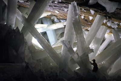 September 11, 2018 Cave of the Crystals: A Geological Wonder with Giant Shimmering Crystals
The post Coconut Crab: The Monstrous Predator that Might Have Killed Amelia Earhart appeared first on .
]]>The post Ennedi Plateau and Aloba Arch: Home to Exquisite Natural Formations and ‘Extinct’ Animals appeared first on .
]]>

Camels arriving at a waterhole in Ennedi. (Wikimedia Commons)
Sahara’s sandstone bulwark
In the northeast of Chad, the Ennedi Plateau spans over the area of Ennedi Ouest and Ennedi Est. While spanning over a large area of 60,000 square km, its highest point is at 4670 ft. above sea level. The Plateau is not just a simple land structure. It has various undulating landforms like towers, pillars, bridges and arches atop it. The Ennedi Plateau is a sandstone bulwark centred on the town of Fada. It is essentially a dry desert owing to its location in the Sahara region.

Sandstone pinnacles in Ennedi plateau. (David Stanley / Flickr)
Fauna of the Ennedi Plateau
One of the primary reasons for the Ennedi Plateau to be declared as a World Heritage site is the vast diversity of fauna that pre-existed and exists on this massive landform. Crocodiles were abundant in this region, once upon a time, and had certain characteristic features like dwarfism, which occurred because of isolation. Threatened by extinction, only a few of these species still survive in river canyons such as the Guelta d’Archei.
The last lions of Sahara became extinct in the 1940s. It is likely that any surviving animals like the Scimitar Oryx Antelopes and the Sudanese Cheetahs may still be found in the sparsely populated areas of the Ennedi Massif. It is also rumoured that a supposed surviving ‘sabre-tooth cat’, also known as the Ennedi Tiger, maybe living there.
Poaching has been prevalent in the Ennedi Natural and Cultural Reserve which has led to a huge decline in the wildlife in the area considerably. There are one hundred and ninety-nine species of birds that utilise the Ennedi Plateau as a migratory crossroad.
The Aloba Arch
When soft rock material gets eroded away by natural agents like wind or water, they form ‘natural arches’. These agents work on worn out rocks susceptible to swift erosion. Sensitive areas include rocks in caves, coastlines, and also areas which have water running through them. Areas that have low frigid temperatures or high-velocity winds that weaken the rocks are also prone to the formation of natural arches. The Aloba Arch in Africa is an example of such a natural arch. Other famous natural arches can be found in Arch Islands in the Falkland Islands, Natural Bridge in Virginia, USA, Natural Arch in Tirumala, India, and the Arches National Park in Utah in the US.
The Aloba Arch is a natural arch in Chad and is a product of the Ennedi Plateau. Large natural arches are uncommon outside the Colorado Plateau of the United States of America and the southern and western areas of China. The Ennedi Plateau in Chad is situated in the north-eastern region, which is near Sudan and Libya. The geological formation of this plateau is strikingly similar to the Colorado Plateau which is in the southwest of the United States. Perhaps the presence of the Aloba Arch echoes these similarities .
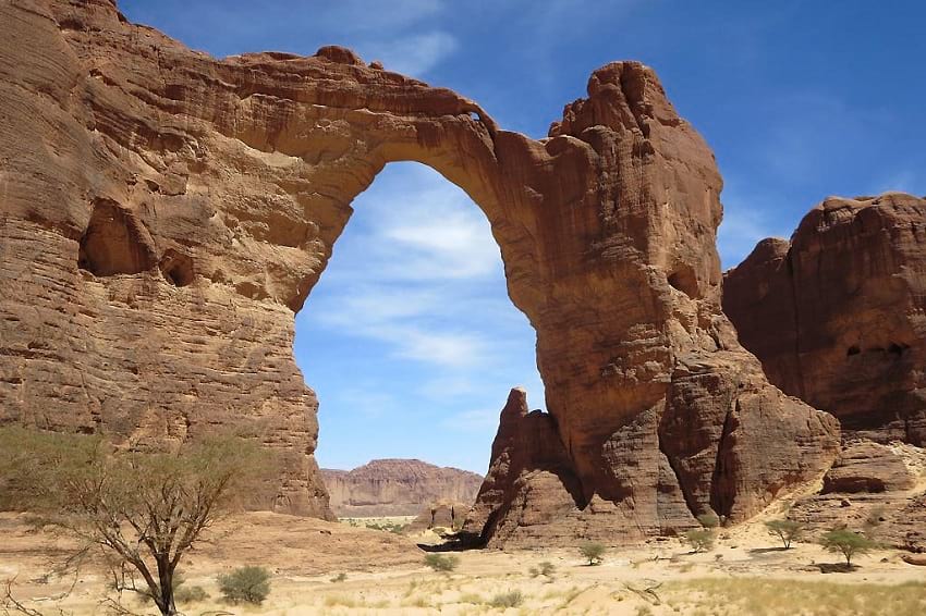
Aloba Arch, Chad. (David Stanley / Flickr)
A massive landform, the Aloba Arch stands tall at a height of 394 ft towering over most natural arches. It also claims the distinction of being the eighth longest natural arch in the world. A two-stage formation took place for the creation of the magnificent Aloba Arch. In the first stage, the upper half of the arch was formed at the end of a fin of a sandstone. The result was a natural ‘buttress type’ arch. The lower part of the arch was formed in a softer layer of sandstone, which was eventually eroded by a stream. Consequently, a type of meandering natural bridge was created. This portion is approximately 150 ft higher than the Rainbow Bridge in Utah.
The native people of Ennedi
The natives of this area are a scarce population of semi-nomads consisting mainly of Muslims speaking the Dazaga dialect. While they live in permanent villages in the rainy season in the months of July-September, they disperse for the dry season. Even after Chad’s independence in 1960, Ennedi remained under the military administration of the French till 1965, as the land was thought to be ‘ungovernable’. The French withdrew thereafter upon being requested by the people of Chad. The plateau is an important resource for the semi-nomadic groups to sustain their livelihood. Their requirements of pastures for the grazing of their cattle, and water, both for themselves and their livestock are met here.

Toubou man, the ethnic group inhabiting northern Chad. (ToubouGa / Wikimedia Commons)
With cooperation, an amazing opportunity presents itself to help conserve this world heritage site to support its people and wildlife. Through constant interaction with the locals, it is possible to deliver effective management, law enforcement, and infrastructure. Even the re-population of several significant animal species that have irreplaceable cultural and natural value, is perhaps possible.
The vandalism of Ennedi cave paintings
The cave paintings here depict animals and communities of people living on the plateau and are one of the largest collections of ancient rock art. This priceless structure has however been systematically defaced by the locals over the years. This act of vandalism has severely mutilated the cave paintings. According to reports by BBC, the locals wrote their names in French and Arabic to deface the paintings.

Rock paintings in Manda Guéli Cave, Ennedi. (David Stanley / Wikimedia Commons)
The cultural minister Mahamat Saleh Haroun refers to the vandalism as a “tragedy”. To assess the damage, experts were sent to the location. According to the UN representative for culture in Chad, Abdel Kerim Adoum Bahar, the paintings can be restored.
Enjoyed this article? Also, check out “Penitentes – The Remarkable Ice Pillars of the Atacama Desert“.
For more unusual stories & intriguing news follow STSTW Media on Instagram and Facebook. Also, join our live chat discussion on Twitter.
Do you have a story/photo for us?
We welcome your contribution at [email protected]. Please include your name, city, state, and country.
Fact Analysis:
STSTW Media strives to deliver accurate information through careful research. However, things can go wrong. If you find the above article inaccurate or biased, please let us know at [email protected].
RELATED
 February 19, 2019 Pontcysyllte Aqueduct: A High-Rise Canal-Connect Made of Cast Iron, an Engineering Marvel
 February 5, 2019 White Sands National Monument: Ace Military Testing Area and an Astounding Tourist Destination
- March 2, 2019 Wave Rock: Where a Massive Prehistoric Wave, Just About to Break, is Etched Permanently in Stone
 April 14, 2019 Fingal’s Cave: The Musical Geometry of Nature’s Domain
The post Ennedi Plateau and Aloba Arch: Home to Exquisite Natural Formations and ‘Extinct’ Animals appeared first on .
]]>The post Tree of 40 Fruits: A Patchwork Canopy of Myriad Fruits appeared first on .
]]>
Tree of 40 Fruit at Syracuse University campus, United States. (Sam Van Aken/Wikimedia Commons)
A single tree bearing 40 different varieties of fruits sounds like something out of science fiction, or maybe a fantasy novel. Sam Van Aken, an art professor with a penchant for agricultural experiments, has transformed this seemingly “mythical” concept into a tangible reality.
What is a Tree of 40 Fruit?
The Tree of 40 Fruit embodies an entire orchard’s produce under a single canopy. The tree bears forty different types of stone fruits- including popular varieties like cherries, apricots, nectarines. A majority, however, comprises ‘antique’ species that seem to fade from existence, if not already extinct. While in summer the tree is ripe with a plethora of unique fruits, it is truly a sight to behold in spring with its branches blooming into myriad pastel blossoms.

The various fruits of the “Tree of 40 fruit”. (Sam Van Aken/Wikimedia Commons)
What inspired the creation of the Tree of 40 Fruit?
Sam Van Aken envisioned the Tree of 40 Fruit to be a piece of natural art. A sculptor himself, Aken deemed the Tree to be like a sculpture that would evolve itself over time if the transformation based on his grafting process was optimally controlled. The Tree of 40 Fruit was conceptualized by Aken as a conservation project. An orchard renowned for producing various native American and heirloom stone fruits on the verge of existence at the New York State Agricultural Experiment Station was shutting down due to lack of funding when Aken stepped in. He bought the orchard in 2008 and thus began the journey towards creating the Tree of 40 Fruit.
Read more: Meet the Rainbow Colour Eucalyptus Tree—Native to the Philippines, Indonesia and Papua New Guinea
How was the tree created?
Aken conducted his project of creating the Tree of 40 Fruit in the orchard he bought, experimenting with approximately 250 varieties of stone fruit trees he had at his disposal. He used ‘chip grafting’ which entails a small slice of a tree (including a bud) on a single pre-existing tree. Aken had already prepared the tree for this process by conducting a few graftings onto the root system. Once the parent tree had reached the age of two, he proceeded to chip-grafting various species onto the tree branches. Once the vascular systems of the plants fuse, they grow as though a single tree. Limiting himself to exclusively stone fruit trees ensured that the grafts Aken was working with were compatible with each other. In addition, Aken had carefully studied the blooming patterns and fruiting timeline of each species and ensured they worked in cohesion after the grafting process. His meticulous experimentation and research finally culminated after five years when Aken had his Tree of 40 Fruit ready.

Fruits harvested from the “Tree of 40 fruit”. (Sam Van Aken/Wikimedia Commons)
How many such trees exist?
While the first was a massive success, Aken did not limit himself to a single Tree of 40 Fruit. He went on to create 21 other such trees, seven of which are in New York. The rest are distributed across the country in parks or in private collections.
Significance of the Trees of 40 Fruit
“They all maintain their own genetic variety”, Aken says about the various species housed within a single Tree of 40 Fruit. This helps preserve numerous ‘heirloom’ species of stone fruits on the verge of extinction due to not being commercially viable. A conservation effort, Aken has helped preserve the various species in all their uniqueness- whether it is in their appearance or taste and aroma. Though the trees are a spectacle bound to draw the awe of onlookers, Aken has made it clear that none of the fruits from the Trees of 40 Fruit are for commercial production and his art is an attempt at preservation.
For more unusual stories & intriguing news follow STSTW Media on Instagram and Facebook. Also, join our live chat discussion on Twitter.
Do you have a story/photo for us?
We welcome your contribution at [email protected]. Please include your name, city, state, and country.
Fact Analysis:
STSTW Media strives to deliver accurate information through careful research. However, things can go wrong. If you find the above article inaccurate or biased, please let us know at [email protected].
RELATED
 August 30, 2018 Saving the Kakapo – The World’s Strangest Parrot
 April 8, 2019 The Manchineel Tree: One of the Most Toxic and Dangerous Tree in the World
 March 6, 2019 The Silky Anteater: The Nocturnal Dweller of the Tropical Rainforests
 May 16, 2020 Xylaria Polymorpha: A Macabre Mushroom that Resembles a Dead Man’s Fingers
The post Tree of 40 Fruits: A Patchwork Canopy of Myriad Fruits appeared first on .
]]>The post A Strange Predatory Link Between Killer Whales and Moose appeared first on .
]]>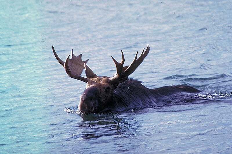
A moose swimming at Isle Royale National Park, Michigan. (NPS staff)
Predation and hunting is an important part of the food chain and has a greater impact on the ecosystem. We all know man occupies the top tier as an apex predator, but besides humans, Killer whales are the dominant and powerful apex predators. Killer whales, also known as Bigg’s Orca, named so after Dr Michael Bigg—founder of modern whale research, have a diverse diet, prey and feast on fishes, penguins, seals, whales, such as humpback whales, and sea lions. Even seabirds are often preyed upon by them, besides marine mammals and birds, they feed on moose or elks as they are known in America and Eurasia, respectively.
Both these animals occupy different habitats yet have an interesting predator-prey relationship. Killer whales are widely distributed in oceans and seas and adapt to all types of climate, thus are found around coastal regions of most of the countries. While moose are territorial animals, that live in boreal and mixed forests of Northern Hemisphere, mainly in Canada.

A bull moose swimming across Glenns Lake. Glacier National Park, Montana, United States. (Jeff P/Flickr)

A pod of orcas swims in Glacier Bay. (NPS)
Killer whales, Orcinus Orca, belong to the dolphin family of toothed whales. While moose, Alces Alces belongs to the subfamily of deers. Both these mammals are the largest members of their respective families. Killer Whales have a large dorsal fin and are black and white coloured; moose have a striking appearance—black in colour, have broad and large palmate/dendritic antlers.

Killer whale emerging from water. (Robert Pittman/NOAA)
Bigg’s Orca are carnivores that feed exclusively on marine mammals—their four-inch-long conical 40-56 teeth, make them most feared and invincible predators. Whereas, moose are herbivores feeding on shrubs, tree barks, twigs, leaves, etc.
In summers, moose prefer to feed on aquatic vegetation, and this search for food makes them vulnerable to attacks by marine predators, i.e., Killer Whales. moose are often preyed and hunted by bears, wolves and humans, and although we have tales of Orca feeding on moose, there aren’t any solid pieces of evidence barring one or two. moose when swimming island to island in search of food, often become defenceless and their speed in water is decreased too thus making them a choicest and rare delicacy for the top-tier marine predators.
The killing of moose by Killer Whale is not unfathomable, as the latter is known to feed on anything and everything it lays its teeth on. And rare instances of Killer whales feeding on moose have been reported, but it’s not certain if it feeds on live animals, thus killing them or feed on the carcass floating in the ocean. These reports and speculations are from findings of deer carcasses in the ocean, but the possibilities could vary. There aren’t enough documented evidence to suggest if moose is a part of Killer Whale’s regular diet and if Killer Whale is a natural moose predator, but the possibilities and conjectures make this water mystery a fascinating tale.
For more unusual stories & intriguing news follow STSTW Media on Instagram and Facebook. Also, join our live chat discussion on Twitter.
Do you have a story/photo for us?
We welcome your contribution at [email protected]. Please include your name, city, state, and country.
Fact Analysis:
STSTW Media strives to deliver accurate information through careful research. However, things can go wrong. If you find the above article inaccurate or biased, please let us know at [email protected].
RELATED
- March 16, 2019 An Up-Close and Personal Encounter with the Alien-Like Pacific Barreleye Fish
 June 1, 2019 Sea Cucumber: The Modest Marine that Needs to be Protected
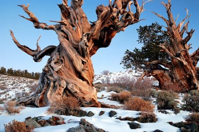 November 11, 2019 Bristlecone Pine: The Oldest Trees of Our Planet
 December 1, 2018 Mapogo Lions: The Six Legendary Lions That Meant ‘Bloody’ Business in Their Quest for Dominance
The post A Strange Predatory Link Between Killer Whales and Moose appeared first on .
]]>The post Xylaria Polymorpha: A Macabre Mushroom that Resembles a Dead Man’s Fingers appeared first on .
]]>
Xylaria polymorpha, commonly known as dead man’s fingers. (Virginia Arboretum / Flickr)
Saprobic fungi grow on and derive its nutrients from dead or decaying plants and tree barks. One such saprobic fungus is the Xylaria Polymorpha that bears an uncanny resemblance to the fingers of a dead charred human and hence acquired the name Dead Man’s Fingers. Typically, a fungus has several stages of growth and ‘mushrooms’ are the reproductive stage of the Xylaria Polymorpha. At this stage, it grows crooked and is yellowish on the tips, much like decaying fingers.

Xylaria polymorpha during its early stage. (AJ Cann / Flickr)
Where can you come across one?
Britain, Ireland and many parts of North America are home to Xylaria polymorpha. The fungus is generally found on the forest floors near remains of dead trees like apple, maple, elm and beech. Several factors contribute to its growth, the most decisive being temperature and moisture. Spring provides optimal balance and temperature for its growth, resulting in big clusters of the fungus around dead tree stumps.

Xylaria Polymorpha growing on a dead tree. (Björn S… / Flickr)
The anatomy of a dead man’s fingers
During its lifespan, it keeps changing its size and colour, which is how it came to be named Xylaria polymorpha, meaning “many shapes”. As mentioned earlier, when young, it exhibits a pale bluish body colour along with a whitish tip. The coating of asexual spores gives its body a blue colour. After it gets a little mature, it attains a brownish-black colour with a coating of sexual, spore-producing, perithecia. It is during this stage that it resembles a dead man’s fingers, often during summer. And as it matures, it can grow up to a length of 14 cm and a thickness of roughly 5.5 cm.
The black coating donned by the mature fungi contains asci, which are essential to the production of the spores. This fungus belongs to the phylum Ascomycota, which is by far the largest section of the fungal kingdom. The spores of these fungi contain guttules—oil like drops and help in reproduction. Each ascus contains 8 spores. Interestingly, despite being a fungus, its texture is like that of wood and is hard.
Read more: Socotra Island of Yemen- The Most Alien-Looking Place on Earth
Why do they look so distinctive?
Wood is mainly composed of cellulose and lignin, with glucans acting as glue. The colours that are displayed by the Xylaria Polymporpha are because of rot fungi. White rot fungi consume or rather digest the lignin and white cellulose remains, hence resulting in the whitish tip during the pre-maturity stage. In the maturity and post-maturity stage, brown rot fungi digest the cellulose and only the brown lignin is remaining, due to which the brown and blackish colouration occurs as it continues to decay. It is precisely due to this appearance and the fact that Xylaria Polymorpha reaches out of the ground that it is called Dead Man’s Fingers. People who are not equipped with information about the fungi can easily mistake it for human fingers sticking out of the ground.
Similar species
There are three species of Xylaria that are so strikingly similar to Xylaria Polymorpha, that they could be wrongly identified and mistaken for Dead Man’s Fingers. Xylaria hypoxylon is a species that resembles the entire anatomy of the Xylaria Polymorpha, except that it is distinctly thinner. On the other hand, Xylaria Longiana is completely identical to Xylaria Polymorpha with the exception of it having smaller spores. There is no other structural difference between the two at all. The differences between some species are so subtle that they cannot be distinguished when we observe them with the naked eye. However, they can be easily segregated based on lab examination of samples of their cultures. Interestingly, this holds true only for the mature mushrooms. At a prematurity stage, the fungi are practically indiscernible even under a microscope.

Xylaria hypoxylon. (James Lindsey / Wikimedia Commons)
Similarities are also observed in the Cordycipitaceae family of mushrooms, but they are identified as parasites. Another group of similar mushrooms is known as Earth Tongue, but they do not form perithecia and are distinguishable from Xylaria Polymorpha on close observation.

Yellow earth tongue. (Bernard Spragg. NZ / Flickr)
Uses of Xylaria polymorpha
Although a lot of mushroom varieties are edible and find their way into various cuisines, the Xylaria polymorpha is inedible when it is mature and may have adverse effects on the human digestive system. There are, however, delicacies that are prepared with shavings of the Xylaria Polymorpha during its premature stage.
The Xylaria Polymorpha has found use in the indigenous Indian medical system of Ayurveda. The powdered fruiting body of the fungus is mixed with sugar and consumed by women after giving birth to promote lactation.
The fruiting body of the fungus is also the source of two polypropionates which have come to be known as xylarinic acids A and B. These acids have anti-fungal properties and helps combat against plant-pathogenic fungi.
Enjoyed this article? Also, check out “The Manchineel Tree: One of the Most Toxic and Dangerous Tree in the World“.
Do you have a story for us?
We welcome your contribution at [email protected]. Please include your name, city, state, and country.
Fact Analysis:
STSTW Media strives to deliver accurate information through careful research. However, things can go wrong. If you find the above article inaccurate or biased, please let us know at [email protected].
RELATED
 July 5, 2019 Rainbow Eucalyptus: A Stunning Demonstration of Nature’s Vibrant Art
- April 8, 2019 The Manchineel Tree: One of the Most Toxic and Dangerous Tree in the World
 June 19, 2020 Tree of 40 Fruits: A Patchwork Canopy of Myriad Fruits
- April 14, 2019 Fingal’s Cave: The Musical Geometry of Nature’s Domain
The post Xylaria Polymorpha: A Macabre Mushroom that Resembles a Dead Man’s Fingers appeared first on .
]]>The post Trigona Spinipes: The Combative Stingless Bee that Lives in Dung appeared first on .
]]>
Trigona spinipes. (José Reynaldo da Fonseca / Wikimedia Commons)
Life cycles of different bees are similar but their lifestyles and feeding mechanisms vary. And while bees are usually known for organized community living and nectar collection, there are bees that defy the norm and do not sting and builds a nest with animal dung. Like, Trigona spinipes, found in Brazil, Paraguay, Argentina, and elsewhere in South America.
Stingless, but not unarmed
Trigona spinipes belongs to the family Apidae. It nests on trees, buildings and other human structures. Inability to sting doesn’t mean inability for self-defence. It can be extremely belligerent and attacks an opponent in a swarm. Shooting into natural openings and hair growth of adversary is a significant offence. Their two mandibles, each having 5 teeth, can inflict a painful bite. The bite, at times, can be so strong that the mandibles can dislodge and prove fatal/suicidal for the bee on the offensive.
Nest and the food source are abridged with odour paths
For gathering food, the stingless bee creates odour-trails. These are zigzag pathways, none going straight from the food source to the nest. Bends on way are meant to mislead an invasive organism, which, otherwise, reach the nest following odour trail. However, the trail is a flawless guide for the friend bees, to move between the food source and the nest. On the flip side, Trigona spinipes too poaches on odour track of other species, to steal from food source of those species.
Literally lives in the trash
They nest at greater heights on vegetation compared to other species. Like any other bee, Trigona spinipes collects into a swarm prior to nest formation. Bifurcation of tree branches is the preferred location. The honeycomb is made up of wax, plant fragments, mud, resins and debris, including dung. Waste material of the bee colony, called scutellum, makes the framework of the bee nest. The length of the nest can vary from 50-60 cm, same for the width. Nest formation is not seasonal, but need-driven. As the honey produced & stored is in a polluted environment—it is unfit for human consumption. Nevertheless, it is used as medicine.

A matured nest of stingless bees Trigona spinipes. The greenish part is a recent addition and is possibly cow or horse dung. (Jorge Stolfi / Wikimedia Commons)
Males are forced into a solitary existence
The life of a bee begins as an egg (3 days duration). Development in the next two stages, larva and pupa, follows a divergent course resulting in the formation of three distinct classes of bee: queen (female), worker (female) and drone (male). The female larvae which are fed a special quality of food, develop into queen bees, others develop into worker bees. The number of worker bees in a colony can vary from 5000 to more than a lakh. Male bees are driven out from the nest. Expelled males (drone) lead a solitary existence (it may last from 4-6 weeks) or join the swarm of worker bees to search for food, and coincidently, find a virgin queen to mate with.
Only one male mates with Trigona spinipes queen
The virgin queen flies out from her parent nest, with a bunch of worker bees, to settle at a new location. The odour of the queen bee attracts males (drone) who lie in wait outside the queen’s new abode. The queen bee flies out to mate. Only one male, out of 30 to 100, from nests scattered far and wide, gets a chance to mate with her. On this count, Trigona spinipes differs from most honeybees which mate with more than one male. After mating, the queen returns to the nest to lay eggs. The eggs that are fertilized by the male, become females (queen bees and worker bees). All unfertilized eggs develop into males.
Queen and worker compete for producing more number of males
The Queen is larger in size and is a prolific egg producer. As head of a nest, she is central to all activities in the honeycomb. The worker bees, being females, also produce eggs, albeit in a limited number. Thus workers and the queen bee become rivals. Unfertilized eggs laid by both of them (queen mates with just one male, so a sizeable part of her eggs remain unfertilized, and workers never mate) develop into male bees (drone). The rivalry goes to the extent that they eat away each other’s unfertilized eggs. Queen tries damage control by placing her unfertilized eggs in the same cell as fertilized ones, to confuse the worker bee. Ostensibly, the queen, as well as the workers have a vested interest in promoting their respective male progeny.
Like most honeybees, Trigona spinipes is a pollinator of agriculture crops, hence farmer’s friend. However, it harms some crops like passion fruit where farmers must guard against it to avoid losses.
Enjoyed this article? Also, check out “Vulturine Parrot: Preserving the Plumes of Pesquet’s Parrots“.
Fact Analysis:
STSTW Media strives to deliver accurate information through careful research. However, things can go wrong. If you find the above article inaccurate or biased, please let us know at [email protected].
RELATED
 September 16, 2019 Maned Wolf: The Existential Crisis of Chrysocyon – the Golden Dog That Looks Like a Fox
- November 11, 2019 Bristlecone Pine: The Oldest Trees of Our Planet
- March 6, 2019 The Silky Anteater: The Nocturnal Dweller of the Tropical Rainforests
 January 31, 2020 Angel Oak: The Magnificent Giant Live Oak of Charleston
The post Trigona Spinipes: The Combative Stingless Bee that Lives in Dung appeared first on .
]]>The post Greenland Shark: The Longest Living Vertebrates to Swim The Arctic Ocean appeared first on .
]]>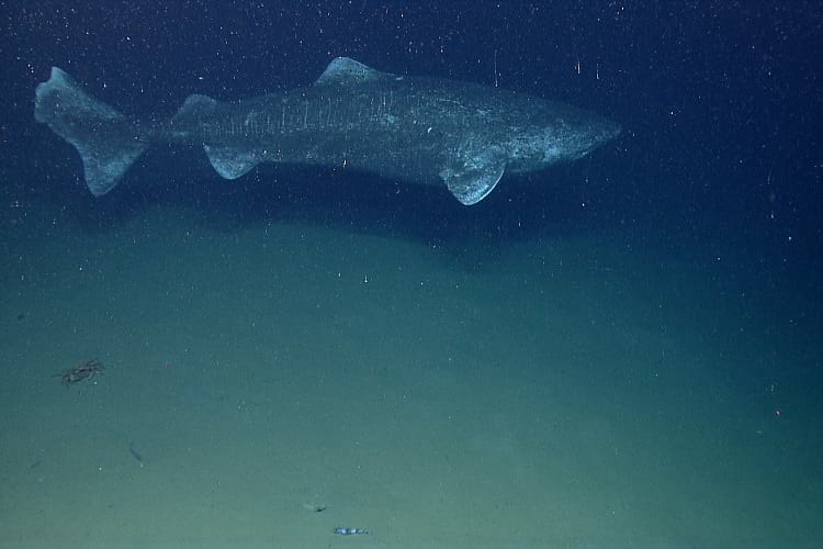
A Greenland shark. (NOAA Photo Library / Flickr)
Greenland sharks, also known as sleeper sharks, grey sharks, or gurry sharks have suddenly gained popularity due to their age being discovered a few months ago. They belong to the family ‘Somniosidae’ and are primarily seen in the Arctic and North Pacific Ocean. They thrive in frigid temperatures and are known to migrate to the coldest areas of the water every season. They are the only known shark species that can survive in Arctic water temperatures all year round.
They also prefer deep areas of the sea as they are found at depths between 0 to 2,200 meters from the surface. Due to their huge size, the sharks swim very slowly and have a sluggish metabolism rate, earning them the nickname of sleeper shark. The longest they grow is up to 4 meters. Though currently unknown, if we were to guess we would say that sharks probably have a lifespan similar to our own – around 70 to 100 years.
How old is the Greenland Shark?
Researchers knew for a long time that these sharks were very old, but were unable to figure out the exact age. For certain species of fish, scientists can examine ear bones that have patterns of concentric rings around them. These rings can be counted like the rings in a tree to determine age.
Another method is to use calcified tissue on backbones of fishes like the Great White (Shark). Finally, if none of these methods is viable, scientists count growth rings on the fin spines and vertebrae. Unfortunately, Greenland sharks are extremely soft and have no hard body parts for any tissue deposition. For the longest time researchers were perplexed by the question of estimating the shark’s age.
Concurrently, a physicist by the name of Jan Heinemeier was conducting a research of his own. He figured that there was a way to age animals by the proteins found in the tissue of their eye lens. This protein is very stable and unlike regular protein doesn’t go through any kind of replenishment through the lifetime of an animal. They are present and encased within the eye since birth. He noted that this method would prove extremely useful in the field of forensics but was unaware of researchers’ conundrum surrounding the shark’s age. Heinemeier also helped crack a murder mystery in Germany using results from his study.
Eventually, Heinemeier was contacted by researchers John Steffensen and Julius Nielsen who were already working on figuring out the shark’s age. They collected eye lenses of 28 sharks over a period of 5 years that were caught unintentionally while catching other target fishes. They procured authorization from the Government of Greenland to conduct the research and immediately euthanized sharks after they were caught so as to reduce the pain of death.
These sharks have a unique eye structure wherein the lens keeps growing as the fish grows. Layers of tissue keep getting added to the lens; while scientists can’t count these layers as they would tree rings, they can keep scraping the layers to get to the centre of the lens. Scientists study this eye lens nucleus to estimate the age of the fish.
They concluded that the youngest of these sharks had been alive for at least 272 years or as high as 512 years. While this method isn’t very accurate it does give you a broad range to work with. With a margin of error of 120 years, they concluded that she is probably 400 years old. Even considering just the minimum, she’s still the oldest known vertebrate on Earth. Greenland sharks grow only 1 cm a year and can grow up to 6 meters in length. Given their slow rate of growth they only reach sexual maturity when they are more than 4 meters long, which happens at about 150 years of age.
The reason they live so long is that they grow slowly. They live in waters just a little above freezing which makes their tissues cold. Cold tissues slow down the chemical reactions within the fish including metabolic rates. If the fish’s metabolic rate is lower, their ageing process is slowed down too.
What’s next for the sharks?
While their extreme longevity may be fascinating to some, it is a cause of concern for environmental biologists. They are listed as a near-threatened species of shark. Because they only mature every 150 years, (and) their rate of reproduction is quite slow. However, they are caught by humans at a much faster rate. Since the early 20th century, at least 30,000 were hunted for their liver oil.
People of Iceland still hunt the fish for its meat where it’s being used in Hákari production. Hákari is a traditional Icelandic dish made of fermented fish. By itself, the shark meat is fatal to humans due to high amounts of trimethylamine oxide (TMAO) present in its tissue. TMAO helps sharks survive the frigid water temperatures. It affects humans in a way that is similar to extreme intoxication. The meat is, therefore, dried and then fermented to drain out the poisonous fluids present in its tissue to make it safe for humans.

Greenland shark meat being fermented. (Chris 73 / Wikimedia Commons)
Not all of the hunting is intentional though, a huge amount of sharks are also caught in nets as bycatch while looking for other fish. This is how the researchers were able to study the sharks’ age without causing any more deaths. Global warming is also another cause of concern for the fish. Since they thrive particularly in colder regions like near the Arctic, we need to protect the environment so that it doesn’t become any warmer than it already has. As the environment becomes warmer, the water temperature rises which would make the waters unbearable for the fish.
To preserve the longevity of the shark, we should learn ways to conserve our endangered species and be more aware and critical of actions that cause global warming.
Enjoyed this article? Also, check out “Goblin Shark: The Alien Shark of the Deep Sea, with a Slingshot Mouth“.
Fact Analysis:
STSTW Media strives to deliver accurate information through careful research. However, things can go wrong. If you find the above article inaccurate or biased, please let us know at [email protected].
RELATED
 November 4, 2019 Goblin Shark: The Alien Shark of the Deep Sea, with a Slingshot Mouth
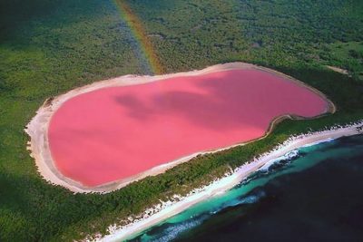 January 15, 2019 Pink Lakes: Where Rose-Tinted Lakes Surrounded By Lush Greenery Are Truly a Sight to Behold
 February 21, 2019 Lake Baikal: The World’s Deepest Lake That Holds 22-23% of the World’s Freshwater
 August 28, 2019 Hoatzin Reptile Bird: A Dinosaur-Like Bird with the Digestive System of a Cow
The post Greenland Shark: The Longest Living Vertebrates to Swim The Arctic Ocean appeared first on .
]]>The post Angel Oak: The Magnificent Giant Live Oak of Charleston appeared first on .
]]>
Angel Oak in Johns Island, South Carolina, US. (Pxhere)
Approximately 4 to 5 centuries ago a majestic tree by the name of the Angel Oak grew in Angel Oak Park near Charleston on Johns Island. The Angel Oak, also a Southern live oak, situated in South Carolina stands tall at 66.5 ft (20 m). The scientific name of this variant of oak is Quercus virginiana.
The Angel Oak, being one of the oldest oaks in Southern Carolina has a circumference of approximately 28 ft (8.5 m) and it produces shade that covers roughly 17,200 square ft. The longest branch of this tree is said to be at least 187 m. The magnificent tree was also registered as the 210th tree by the Live Oak Society.
What’s so angelic about the Angel Oak?
The Angel Oak derives its name from the couple who owned the Angel Estate, Justus and Martha Waight Angel.
According to records of ownership, the tree and the land on which it stands, belonged to Abraham Waight, who was given the land as part of a land grant in 1717. Abraham Wraight was a very rich man, who was also the owner of several plantations. The land had been in the Waight family for many generations and was one of their most valued lands. In 1810, when Martha Waight Tucker married Justus Angel, the estate was a part of their marriage settlement which was a norm in those times. Today, this magnificent tree is the focal point of the Angel Oak Park in South Carolina and is owned by the city of Charleston.
Some people may claim that the Angel Oak is the oldest tree found to the east of the Mississippi River. However, there are many bald cypress trees that can be found throughout North and South Carolina that are estimated to be much older.
Local legends state that appearances of ‘angels’ around the tree that happened to be the ghosts of former slaves adds another layer of meaning to the name of the tree.
Charleston’s iconic Angel Oak tree
In 1989, the Angel Oak was severely damaged during Hurricane Hugo but it has recovered since then and continues to grow. Southern live oaks are said to be native to the lowland country. They are said to grow more outward than upward. However, due to its age, the Angel Oak does both. The branches of the tree extend in all directions, with some going underground and then growing back up above the surface. The tree’s trunk is extremely heavy and large, with some branches dropping to the ground which is a popular trait of extremely old oak trees. Over the years, the Angel Oak has survived rough weather including hurricanes, earthquakes, floods as well as human interference.

The branches of Angel Oak tree. (Chuck Allen / Flickr)
Recently, there was a plan for apartment development near the mighty Angel Oak, which was scrutinised and fought against by South Carolina Coastal Conservation League. They argued that the development of the apartment complex would alter the flow of groundwater to the tree. This would clear the “nearby forests whose root systems” were intertwined with the Angel Oak.
The Angel Oak is also said to have featured prominently in Emily Nelson’s novel “The Heart of a Child”. The area also hosts a number of artistic social events throughout the seasons of spring and summer. In 2000, it was acknowledged as a Millennium Tree, and it was the South Carolina Heritage Tree of the year in 2004.
Why visit the grand Angel Oak of Charleston?
The elegant tree and the surrounding greenery make it a popular and grand venue for several events like professional photo shoots, receptions and weddings. The Angel Oak serves as a magnificent backdrop for almost any occasion. For all the shutterbugs and people who love to be photographed, the Angel Oak provides one of the best photo opportunities. Its position also affords a beautiful panoramic view of the area.
There are also several picnic spots near the precious Angel Oak. Visitors are allowed to have a picnic and enjoy the view under its huge canopy. The entire atmosphere exudes a certain serenity and quiet warmth.
There are a host of local gift shops in and around the area that have photo prints, postcards and other items. If you take a tour around the city, you will notice that most of the small tourist shops are quite vintage in their setting.
Angel Oak under threat
There have been several indirect threats against the Angel Oak, because the trees in the surrounding forest were going to be felled. It affects the tree’s root system and the ecosystem surrounding it. During a torrential downpour, the surrounding trees are what protects the Angel Oak’s root system and prevent heavy erosion of the soil. They provide “shelter from storms” and also provide adequate moisture and drainage. It is absolutely essential, thus, to not only focus on the tree but the protection of its surroundings which sustain it. Before reaching the tree’s roots, bark, and leaves, it filters several harmful pollutants. Consequently, any development around it could be harmful to its survival.

Ferns growing on the angel oak. (Lil Rose / Flickr)
The South Carolina Environmental Law Project and the Lowcountry Open Land Trust deserve much credit for their work. Their efforts are behind the Angel Oak still standing tall and proud today. In order to prevent the limbs from breaking off, adjustments have been made to the ancient tree. Wooden and metal posts have been put up, along with steel wires, to help the larger and more unstable branches.
An Experience to Remember
Located at 3688 Angel Oak Road, it is 12 miles from downtown and is surrounded by unique restaurants nearby. One of the many wonderful restaurants is the ‘Fat Hen’ which has a “French Lowcountry dining experience”. They serve dinner six days a week and are renowned for their scrumptious Sunday brunch. There are several other tasteful restaurants that may be found in Johns Island near the Angel Oak.
Enjoyed this article? Also, check out “The Story of the Last Tree of Ténéré is Short and Sad“.
Fact Analysis:
STSTW Media strives to deliver accurate information through careful research. However, things can go wrong. If you find the above article inaccurate or biased, please let us know at [email protected].
RELATED
 October 11, 2018 Socotra Island of Yemen: The Most Alien-Looking Place on Earth
 March 29, 2019 The Unsolved Mystery Behind the Devil’s Tramping Ground in North Carolina
 April 25, 2020 Trigona Spinipes: The Combative Stingless Bee that Lives in Dung
- August 30, 2018 Saving the Kakapo – The World’s Strangest Parrot
The post Angel Oak: The Magnificent Giant Live Oak of Charleston appeared first on .
]]>The post Incredible Snake Island: One of the Most Uninhabitable Places in the World appeared first on .
]]>
Ilha da Queimada Grande, also known as Snake Island. (Prefeitura de Itanhaém / Flickr)
About 21 miles off the Brazilian coast lies the Ilha da Queimada Grande, also known as Snake Island. It is an island infested with snakes. Snake Island measures around 106 acres, and from sea level, the terrain rises to 676 feet. It has a diverse landscape, with bare rocks near the water and open grasslands and a rainforest higher up. The rainforest makes up around 62 acres of the island. The deforestation at the lower level is due to fires that the locals started in an attempt to clear the rainforest and also to kill off the snakes to start banana plantations.
The plan didn’t work out too well, but the fires and deforestation gave the island its name Queimada Grande. In Portuguese, Queimada Grande roughly translates to Burn Fire or Big Burnt Island.
In 1909, the Brazilian authorities built a lighthouse on the island to direct ships away, and a lighthouse keeper and his family lived on the island for a period. Later, the authorities decided it was far better to automate the lighthouse, and no one has lived on Snake Island ever since.
There is no beach on Ilha da Queimada Grand and accessing the island via the algae-covered rocks is quite difficult. However, as the island is uninhabited and very few people visit, it is not much of an issue. The climate on the island is temperate.
The Snakes on Ilha da Queimada Grande
There are two species of snakes on Ilha da Queimada Grande—the venomous Golden Lanceheads, also known as the Bothrops insularis, and the non-poisonous Dipsas albifrons. However, most people have only heard about the Golden Lanceheads, which are a species of pit vipers.

Bothrops insularis or Golden Lanceheads. (Miguelrangeljr / Wikimedia Commons)
In Brazil, pit vipers are the most dangerous snakes as far as humans are concerned. Over 90% of the fatalities that occur in Brazil due to snake bites are from pit vipers. However, the venom of the Golden Lanceheads is even more potent than that of their mainland cousins as they evolved separately.
Originally, many millions of years ago, Ilha da Queimada Grande was part of the mainland. The rising sea levels, however, cut it off and transformed it into an island. The pit vipers that were on the island now became isolated, and, as there were no predators to cull them, they bred and proliferated.
However, the only prey they had a chance at getting were migratory birds that landed on the island; the local birds were too smart for the snakes. Out of the 41 bird species that visit the island, the snakes are only able to catch and eat the southern house wren (the Troglodytes musculus) and the flycatcher (the Chilean Elaenia).
To catch these birds, the snakes had to develop specific features to survive.
The Golden Lancehead’s venom, for instance, had to be strong enough to stun and kill the birds before they had a chance to escape. Aside from being quick-acting, the venom also burns the flesh around the bitten area. Neither birds nor animals stand a chance once they are bitten by a Golden Lancehead, and that goes for humans as well. There is no guarantee that people will survive a bite from one of these snakes even if they do receive prompt medical attention.
And there are so many Golden Lanceheads on Ilha da Queimada Grande that the chances of getting bitten are high. While the popular notion is that there is one snake in every square meter on the island, the estimates are probably lower. Rather than 430,000 or thereabouts, there are only about 4,000 snakes on the island, and most of these are in the rainforest area.
As the population is small it leads to inbreeding causing genetic defects—such as Golden Lanceheads with two heads. Also, the competition for resources is stiff.
Ilha da Queimada Grande is the only place on earth where Golden Lanceheads exist. These snakes are a critically endangered species and appear both on Brazil’s endangered species list and the Red List of Threatened Species by the IUCN.
Tales of the Deadly Snakes of Snake Island
Rumour has it that once a fisherman decided to stop at the island to pick bananas from the abandoned banana plantations. Coming under attack from the Golden Lanceheads, he had to flee back to his boat. He made it onboard, but, by this time, the venom had spread throughout his body. When people came looking for him a few days later, they found him lying dead in a pool of blood on the boat deck.
Another chilling story is about the fate of the lighthouse keeper and his family. While there is no official confirmation about their fate, the rumour is that one night several Golden Lanceheads slithered in through a window into the family’s dwelling and attacked them. The family panicked and ran from the house towards their boat. However, the snakes in the trees bit them as they fled past. Later, searchers found the dead bodies of the family around the island.
Visiting Snake Island
You’ve probably crossed Ilha da Queimada Grande off your travel itinerary by now. In any case, the Brazilian government does not allow tourists to visit Ilha da Queimada Grande. A board on the island announces that the disembarking is prohibited.
It is both for the protection of the tourists and also to protect the endangered snakes. Only members of the Brazilian Navy, the technicians who carry out maintenance work on the automated lighthouse, and herpetologist and other researchers, who have official permission from the Chico Mendes Institute for Biodiversity Conservation, can visit the island.
The researchers capture the snakes, weigh them, and microchip them for research purposes. The venom has medical uses for treating heart disease, blood circulation issues, blood clots, and cancer according to biologist Marcelo Duarte of the Brazilian Butantan Institute.
Unfortunately, the potential of the venom has brought the Golden Lanceheads to the notice of wildlife smugglers who trap these snakes and sell them illegally. One serpent can go from anywhere between $10,000 to $30,000.
Enjoyed this article? Also, check out “Assateague Island and its Feral Horses“.
Fact Analysis:
STSTW Media strives to deliver accurate information through careful research. However, things can go wrong. If you find the above article inaccurate or biased, please let us know at [email protected].
RELATED
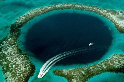 December 4, 2019 Great Blue Hole: Largest Underwater Sea Hole off the coast of Belize is a Diver’s Paradise
- April 14, 2019 Fingal’s Cave: The Musical Geometry of Nature’s Domain
 December 18, 2019 Punta del Hidalgo Lighthouse: A Celebration of Modern Architecture and Traditional Utility
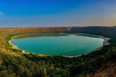 July 17, 2019 The Lonar Lake: An Astronomical Marvel
The post Incredible Snake Island: One of the Most Uninhabitable Places in the World appeared first on .
]]>The post Australian Bushfires: Deadly Yet an Inextricable Part of the Australian Ecosystem appeared first on .
]]>
Bushfires in Australia. (bert knottenbeld / Flickr)
In Australia, bushfires occur almost every other day and continue with a rapid movement across any terrain. Even though fires may be considered more like a bane than a boon, Australia’s ecosystem has adapted to these bushfires and, in fact, it forms an integral part of its ecosystem. Some bushfires are naturally occurring while some are man-made. Although we have no control over the natural fires that occur, the human population of the region can implement certain safety measures to reduce the damage caused by these bushfires.
What causes the bushfires?
Bushfires spread quite rapidly compared to normal fire, however, it is not as fast as the outbreak of a deadly grassfire. The reason why Bushfires are such a common occurrence in Australia may be attributed to the presence of elements like fallen leaves, barks, and other dry material, that are easily combustible. The weather conditions in Australia are favourable for bushfires, as the scorching heat maintains a constant state of drought in parts of the continent. These factors coupled with strong winds make it just the right combination for the fires to start. While most of the causes are from activities conducted by humans, sometimes the widespread devastation caused by bushfires is triggered by lightning. Emission of greenhouse gases, sparks from power lines, and global warming caused by humans, are other contributing factors to the increasing bushfires in the Australian subcontinent.
Fire ecology of Australia
The Department of Biodiversity, Conservation and Attractions of Western Australia states “Many plants hold their seeds in thick woody fruits or capsules, where they are protected from fire. The heat of the fire assists in opening the capsules, allowing the seeds to be shed within a few days. When the seeds fall to the ground they land in the ash bed, which is high in the nutrients needed for strong seedling growth.”
Bushfires, over the years, have actually become an essential part of the Australian ecosystem. Many of the indigenous flora has evolved to not only survive the flames, but also to benefit from them. The plants have adapted themselves to survive by sporting thick barks, leaf sheaths, below-ground roots, and underground stems. One interesting adaptation is above-ground re-sprouting that uses epicormic buds for reproduction, in the event of a fire. These buds are located below the bark thus ensuring their safety in case of a bushfire. This unique adaptation of fire-activated seeds has helped increase productivity in farms and other forest areas. Once the foliage has been cleared by bushfires, the sunlight falls directly on the soil. This improves soil quality and facilitates improved regeneration of the plants. These plants are termed as “Pyrophytic plants”.

A panoramic photo of a wildlife refuge recovering from forest fire over a period of two years. (U.S. Fish and Wildlife Service Southeast Region)
Fires used by birds and humans
The Australian Aboriginal Lore is a species of bird that has set a precedent for both humans and other birds to draw inspiration. In order to capture their prey, the Australian Aboriginal lore has been using fire for centuries to hunt their prey, following which other species of birds such as the Australian Raptor have also used fire as a means of hunting. Humans have also followed suit and made changes to their ways of farming and clearing out the lands for fresh crops.
Australian Aborigines, or what we call indigenous Australians, have made progress in using pyro-techniques more effectively by understanding how the birds use it to hunt their prey. It is considered a tradition in the indigenous tribe and has been a part of their culture. Some tribes have discontinued the use of pyro-techniques owing to the lack of control they have over the fire. The technique called fire-stick farming, dating back to over 120,000 years ago, had also evolved as a pyro-technique for farming. Though this technique was discontinued by most, officials in Australia are considering using these aboriginal farming techniques to control the fires growing frequency of bushfires, and improve the current condition of land management employed by the modern-day farmers.
Effects of the fires
The air quality of a region is quite a critical factor that governs the over-all health of the populace. The forest fires have ensured that the air quality in Australia is sub-par, which is especially concerning for big cities, like Sydney, that suffer from air quality more than 20 times worse than desirable. Consequently, people suffer from intense respiratory issues and other ailments making their daily life difficult.
A technique called ‘back burning’ has been used to get rid of any vegetation that may serve as fuel for future fires caused by man-made or natural factors. This involves the burning of bushes in a controlled manner which can ideally be put out at any time. Even though the concept was to have controlled bushfire outbreaks, some have spiralled out of control and claimed lives and damaged property.
Among other things, loss of livestock is very common during bushfires.
Bushfires changing the climate?
With the increasing intensity and number of bushfires, it has been established by the Bureau of Meteorology in Victoria that the phenomenon is generating its own weather conditions. This weather incites thunder and lightning which are generating more bushfires as time progresses. The clouds that are forming due to the bushfires are called pyro-cumulonimbus clouds and are also generating smoke-filled air which degrades the general air quality. Due to the sheer intensity of the bushfires and strong winds coupled with the Pyro-cumulonimbus clouds, there have been instances where a fire vortex or fire-tornado is created and causes severe damage to the areas in its path.
The fires are causing so much devastation across Australia at the moment that people are constantly evacuating their homes and taking shelter in public spaces such as beaches and parks that have a wide-open space and are less prone to bushfires. While the bushfires generate their own weather, they are also making the sky look red. People have been asked to be prepared for the worst.
Loss of habitat
While us humans can escape and evacuate promptly when danger strikes, most animals may not be able to do the same and end up getting trapped in the blaze.
Koalas are an integral part of the Australian wildlife and have recently been under threat because of the increasing bushfires occurring in and around Sydney. In one such case, a koala bear had been wandering and found itself trapped in a bushfire. Luckily a woman had spotted that koala bear from far away, the woman rescued the koala from the blaze by covering it with her own shirt. However, unable to recover from the burns the koala later succumbed to burn injuries.
What we can take from this is that humans are not the only ones being affected by the bushfires in Australia. Putting up effective countermeasures will not only help humans but also animals who are extremely helpless in such conditions. While Koalas remain an integral part of Australia’s ecosystem, they are under a massive threat. The Australian Koala Foundation places the death toll of the animal at a thousand and counting. The bushfires have destroyed more than eighty percent of their habitat and have rendered the remaining “functionally extinct” since the koalas only consume parts of the eucalyptus trees, which have been burnt down in the bushfires. Roughly only 43,000 koalas are still left in the wild, and measures need to be taken to safeguard the ecosystem successfully.
Countermeasures for the bushfires
With almost 4 million hectares of land consumed by bushfires and countless lives lost, the Australian Government has made plans to counter the bushfires by deploying naval and air forces to help people evacuate and at the same time assist the firefighters to mitigate the fires. To avoid more sparking of bushfires, certain areas have been cut off from any form of electricity. Scott Morrison, the Australian Prime Minister has pledged to reduce the greenhouse gas emissions down by 26-28% which if followed, will reduce bushfires drastically due to reduced heat conditions. While all that may seem like a plan for the future, the areas that have already been affected are getting support from the government in terms of money, food, fuel, and water. Most importantly, people are being evacuated in an orderly manner to help them escape the rampaging bushfires.
Want to share photos of the Australian bushfire? Email your photos to [email protected].
Enjoyed this article? Also, check out “Forest Fire: Birds Deliberately Setting Forests on Fire to Flush Out Prey“.
Fact Analysis:
STSTW Media strives to deliver accurate information through careful research. However, things can go wrong. If you find the above article inaccurate or biased, please let us know at [email protected].
RELATED
 April 20, 2019 Forest Fire: Birds Deliberately Setting Forests on Fire to Flush Out Prey
 May 10, 2019 The Great Emu War: When Thousands of Emus Evaded Australian Armed Forces and Won the War
- March 2, 2019 Wave Rock: Where a Massive Prehistoric Wave, Just About to Break, is Etched Permanently in Stone
- January 15, 2019 Pink Lakes: Where Rose-Tinted Lakes Surrounded By Lush Greenery Are Truly a Sight to Behold
The post Australian Bushfires: Deadly Yet an Inextricable Part of the Australian Ecosystem appeared first on .
]]>The post Light Pillars, an Insight into Nature’s Spectacular Optical Phenomenon appeared first on .
]]>
Photo of light pillars in Laramie, Wyoming on a cold winter night. (Christoph Geisler / Wikimedia Commons)
We are all well aware of how the harshest conditions like those of the Arctic region present us with some of the most beautiful wonders of nature and some very unusual optical illusions. Some of these illusions and wonders are limited to those regions. But thanks to the unrelenting torture that we have been putting this planet through seems to be altering our weather patterns in a very wrong way.
In the year 2017, we witnessed one of the coldest winters all over North America. While people had to endure the bitter cold, they witnessed a colourful upside. Twitter and Instagram were filled with pictures taken by photographers all over North America of bright colourful light pillars that dazzled people all over the world. The skyward shooting light pillars or poles lit the night sky with colours ranging from yellow, blue, red, green and white.

Photo of light pillars taken in North Bay Ontario. (Timmyjoeelzinga / Wikimedia Commons)
How do Light Pillars occur?
Light pillars or poles are a natural phenomenon caused by the presence of a large number of ice crystals “normally present in high clouds floating in the air close to the ground”. These flattened hexagonal plate-shaped ice crystals which are usually horizontal act as mirrors reflecting the light downwards. They are beams of gathered light from millions of crystals which reflect the incoming beam of light into the eyes or camera to create this illusion.
These are usually seen in regions where the temperatures fall as low as the Arctic region because under normal weather conditions of North America the ice crystals are not present close enough to the ground to form the poles of light. But during the past winters, these were even visible as far south as the state of Ohio, USA when the temperatures hit a record low.
While this might be a sight to behold, there remain some unanswered questions. Is it a precursor to further, drastic climatic change? Should this be taken merely as nature’s marvel? Can we continue to keep our eyes closed towards climate change?
But while we answer these questions and figure out a plan of action to save our planet from further destruction at our own hands, I don’t see any harm in enjoying the beautiful sights that Mother Nature is offering us.
Enjoyed this article? Also, check out “Noctilucent Clouds: Shining in the Summer Twilight Sky”.
Fact Analysis:
STSTW Media strives to deliver accurate information through careful research. However, things can go wrong. If you find the above article inaccurate or biased, please let us know at [email protected].
RELATED
 October 16, 2018 Clear Water Lagoons and Pristine White Sand Dunes of Lençóis Maranhenses National Park
 February 20, 2020 Greenland Shark: The Longest Living Vertebrates to Swim The Arctic Ocean
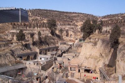 June 27, 2019 Traditional Yaodong, Shaanxi Province: The Cave Dwellings in Which Many Chinese People Still Live
- March 16, 2019 An Up-Close and Personal Encounter with the Alien-Like Pacific Barreleye Fish
The post Light Pillars, an Insight into Nature’s Spectacular Optical Phenomenon appeared first on .
]]>The post Scaly-foot Gastropod: A Snail with an Iron Armour That Lives Near the Hydrothermal Vents appeared first on .
]]>
Scaly-foot gastropod: Three discovered varieties of C. squamiferum: Kairei, Longqi, Solitaire (left to right). (Chong Chen / Wikimedia Commons)
The scaly-foot snail or scaly-foot gastropod has an ironclad body, with a metal shell wrapped around its delicate interior. Its scientific name is Chrysomallon Squamiferum and is commonly referred to as the “Sea Pangolin”. This species was only recently discovered by researchers in 2003, and they live at astonishing depths of about 9,500 feet, on the seafloor near hydrothermal vents in parts of the Indian Ocean.
The scaly-foot snail has been listed as an endangered species in the Red List by the International Union for Conservation of Nature, owing to human activities like Deep Sea Mining that have contributed to the destruction of its natural habitat. The scaly-foot snail’s habitat also lends itself to the production of high-quality metal ores, as the hydrothermal vents are a rich source for iron sulfides and a lot of other minerals. This encourages deep-sea mining to be conducted on a very large scale.
A coping mechanism for surviving an extreme habitat
With the scaly-foot snail’s habitat located about 1.5 miles below the sea level, the oxygen levels at these depths are rather low. Near the hydrothermal vents, temperatures can go up to 400 degrees Celsius (750 degrees Fahrenheit). These conditions make life here extremely challenging, however, the scaly-foot snail has adapted and survived these conditions owing to its special physiological features.

Scaly-foot gastropod in its natural habitat. (Wikimedia Commons)
The scaly-foot snail has developed a heart that is proportionately much larger compared to the size of its body. In fact, it has the largest heart to body proportion in the entire animal kingdom. The gigantic heart helps in proper blood circulation as well as enhanced oxygen exchange, thus combating the extremely low levels of oxygen.
To withstand the extreme temperature and pressures near the hydrothermal vents, the snail has developed an iron-clad shell. Scientists believe that the shell is produced from the toxic iron sulfides pouring out of the vents with the help of microbes. Its shell is covered in greigite and pyrite. Pyrite is known as “Fool’s Gold” and greigite is magnetic in nature which means the animal would actually get stuck to magnets.
Biological adaptations to fend off marine predators
The scaly-foot snail has a tough exterior and exhibits scales made of calcium carbonate. To combat predators, the ‘weaker’ species tend to adapt. A three-layered shell structure has served adequately for the scaly-foot gastropod. The shell comprises an outer layer- mainly composed of iron sulfide granules which give the shell its metallic covering, a thick organic middle layer, and a calcified inner layer.
Apart from this, the snail also has several energy dissipation mechanisms that help fend off predators. Such mechanisms also protect the shell from cracking when pressure is applied by predators like crabs.
The scaly-foot snail gets its name from the metallic scales present on the lower part of its body. This is also an adaptation to combat venom injected by predators into their delicate bodies. That being said, even if there were no metallic scales on its body, the snail could simply retract when attacked by a predator, and eventually float away due to the volatile nature of hydrothermal vents.
Food habits
The food source of the scaly-foot gastropod mainly comprises of the microbes that react with the chemicals on its shell. These microbes are essentially chemoautotrophic endosymbiotic bacteria that survive on the snail’s body. At the same time, they provide all the nutrition that the scaly-foot snail requires.
Reproductive system and other anatomical features
The scaly-foot snail has been classified as a simultaneous hermaphrodite, meaning it has both female and male reproductive organs. It has a genital opening which is located right beside the mantle edge. Research also shows that it has a non-ganglionated nervous system and, a very simple digestive system. The ctenidium is an important part of the scaly-foot gastropod’s anatomy, housing the blood sinuses. The posterior of the ctenidium contains the rather well-developed and large heart of the snail.
Variations of the scaly-foot snail

Illustration of the two varieties of scaly-foot gastropod. (Rachel Caauwe / Wikimedia Commons)
There are essentially two varieties of the scaly-foot snail, both in roughly the same habitat and under the same conditions. The reason for the differences between the two variants- the black scaly-foot snail and the white scaly-foot snail- arises due to the difference in the bacteria involved that causes the colouration. The Black scaly-foot snail has a certain bacteria which the white supposedly lacks. These bacteria are highly beneficial for the species and help make the iron sulfide shell. Not only that, but it also combats the toxicity from the hydrothermal vents and makes the armour/shell of the snail naturally poisonous. The colouration of each snail also varies depending on the amount of iron near the hydrothermal vent where the snail resides.
Deep-sea mining and its effect on the scaly-foot gastropod
Vacuuming is the process used to collect minerals off the seabed. This deep-sea mining activity has resulted in the destruction of the habitat of the scaly-foot gastropod. The International Seabed Authority (ISA) is developing a few rules and regulations that will be put in place to curb the destruction of the gastropod’s habitat. The 168 member body formed by the United Nations, has a clock ticking till 2020 to put together these new rules. As the demand for rare minerals that support modern technology increases, the deep-sea mining activities also gradually increase to fulfil those requirements. One can only make the activity more sustainable, as completely doing away with it is not an option.
Curbing an environmental disaster
Several experts have stated that there is no substitute for the habitat in which the scaly-foot gastropod thrives. Activist group Greenpeace wants to put a halt to mining activities until the deep ocean is understood better. However, instead of conserving the nature and the snail’s habitat, the International Seabed Authority has been specifically selling off mining contracts and serving the industry to benefit them monetarily.
Many hydrothermal vents are rich in gold, zinc, cobalt, lithium, manganese, and copper that are highly beneficial to the industry. To maximize the output of these metals from the seabed, 500,000 square miles of the seabed floor have been licensed off without caring for the natural habitat of the deep-sea creatures. The scaly-foot snail is only the first creature to be declared endangered due to deep-sea mining. According to scientists, there might be another 14 species of snails and other deep-sea creatures to be added to the IUCN Red List of Endangered Animals, due to mining conducted in these areas. Recently, 28 scientists wrote a letter to the authorities of the ISA requesting a halt to the mining activities, before irreversible damage is done to the seabed. The scaly-foot snail is one of its kind and faces a very big threat to its existence. To sustain this unique species, urgent action needs to be taken to promote its conservation.
Enjoyed this article? Also, check out “Hoosier Cavefish: The Blind Cavefish from Indiana Named after Their NCAA Basketball League“.
Fact Analysis:
STSTW Media strives to deliver accurate information through careful research. However, things can go wrong. If you find the above article inaccurate or biased, please let us know at [email protected].
RELATED
 June 30, 2018 The Near Endangered Honduran White Bat of Central America
- November 11, 2019 Bristlecone Pine: The Oldest Trees of Our Planet
 May 24, 2019 Himalayan Monal: The Nine-Coloured Bird of the Himalayas
- April 14, 2019 Fingal’s Cave: The Musical Geometry of Nature’s Domain
The post Scaly-foot Gastropod: A Snail with an Iron Armour That Lives Near the Hydrothermal Vents appeared first on .
]]>The post Vulturine Parrot: Preserving the Plumes of Pesquet’s Parrots appeared first on .
]]>
Pesquet’s Parrot (Psittrichas fulgidus). (Peter Tan / Flickr)
Much of the modern industrial world can be blamed for unbalancing our delicate ecosystem and driving many species to extinction. Less maligned (and rightly so) are the more traditional cultures, living off the land and leaving it as they found it. If largely undisturbed, it will retain the high probability of returning to its original state of Gaia. Yet, there are a few exceptions to this notion, notably in Asia and the central belt of Africa, where poaching has made several species of Pangolin endangered (their scales are said to improve ailments in humans). A similar tragedy is erupting in Papua New Guinea also. One such species that is under threat here is the Vulturine Parrot, another moniker for Pesquet’s Parrot, a fig-eating species who dwells in the nooks and crannies of trees.
The Bird’s Habitat and Diet
Pesquet’s parrots are indigenous to the island of New Guinea, living in hills and mountains at elevations of over 600 meters. Being frugivorous, their favourite food is figs, especially the ones found on Ficus trees but they will consume softer items such as fruits like mangos and bananas. As well as flower blossoms and nectars if necessary. Breeding takes place in the nooks and crannies of hollow trees, where nesting eggs will typically have a maximum incubation time of 30 days.
Traditional garments
Some feathers of these birds are so naturally eye-catching that many natives of the volcanic island will adorn them as part of their attire for special occasions – mostly as a form of hat. They are almost exclusively made of plumage from the bodies of Pesquet’s Parrots among others. The headdresses are called Bilas and are essentially extravagant plumes emanating from the top of a wearer’s head.

A performer from Papua New Guinea wearing a Bilas. (Afrikit / Pixabay)
While the Pesquet’s parrots have mostly black features on most of its body, it is the striking red feathers on its underbelly which is the most sought after. The demand for said feathers is causing an issue. So much so, that the birds in question have been forced onto a path of extinction. Three birds need to be killed in order to make one headdress alone. The animals are selling for a high price.
Conservation of Pesquet’s parrot
Efforts to save the Pesquet’s parrot have fallen on deaf ears, especially in a country where communication is difficult. The flight-path and habitats of the species stretch all across the island which adds to the difficulty. For this reason, instead of saving them, scientists are now proposing that they protect – or rather the wearers – protect the headdresses, so they don’t need to be replaced so frequently. They are seldom adorned – sometimes only once a year for wedding ceremonies – so they should be maintained better is the voice of many activists. Owners are encouraged to wrap them in bamboo sheets or to keep them in sealed storage containers. A conservation-NGO called WCS has even created protection kits which they send out for free to anyone who wants them.

The Pesquet’s Parrot has a featherless face, which was most likely adapted to avoid a sticky face from the fruit’s pulp. (Doug Janson / Wikimedia Commons)
Their ethos remains,
“The PNG [Papua New Guinea] country vision fits within the global vision of WCS [Wildlife Conservationist Society], which “envisions a world where wildlife thrives in healthy lands and seas, valued by societies that embrace and benefit from the diversity and integrity of life on earth.
PNG retains large areas of intact rainforest and globally important wildlife such as the iconic and spectacular Birds of Paradise and the giant flightless Cassowarys, unusual mammals such as Tree Kangaroos and the egg-laying Long-beaked Echidna, and the world’s most diverse coral seas”.”
Substitute feathers are also an option, as is borrowing from relatives and friends. But these techniques are vastly unpopular as it goes against tradition and the mindless momentum of fashion.
A former Miss Papua New Guinea, Grace Nugi’ is now one of the most prominent protesters. She states that these particular feathers were not used until the 1960’s (with any feather being used in the past) therefore it is not a long-held tradition to use the Pesquet anyway. More so, the frequency of festivity has changed, as the younger generations will wear the Bilas at more events than just weddings, such as at graduations.

Pesquet’s parrot perching on a branch. (Greg Hume / Wikimedia Commons)
Author’s opinion
If you handed an image to people, showing the carcasses of Pangolins and Pesquet’s Parrot, most would feel an element of sadness. And this would be heightened, if you explained that these species are being hunted to the edge of extinction for fancy clothes and scientifically-unproved medicines. And yet not many people would change their ways if they were directly involved in the culling of these animals. We see it every day, in every corner of the world, where our indifference towards the suffering of these creatures and our world is staggering. To those who commit the acts, the only explanation for the majority can be that money breeds malice in mankind. The Neanderthals who do not see it a problem should be castigated less as they have no control over their education or DNA. As should those who were born into the world without hope, and desperately need the money.
It seems that NGOs and protesters can only do so much, and in Papua New Guinea – as with the rest of the world – extreme measures will have to be made by governments if we are to have any chance of saving species, saving our world and saving ourselves in the process.
Enjoyed this article? Also, check out “Hoatzin Reptile Bird: A Dinosaur-Like Bird with the Digestive System of a Cow“.
Fact Analysis:
STSTW Media strives to deliver accurate information through careful research. However, things can go wrong. If you find the above article inaccurate or biased, please let us know at [email protected].
RELATED
- August 30, 2018 Saving the Kakapo – The World’s Strangest Parrot
 January 8, 2019 Proboscis Monkey: The Rare Borneo Monkey Species with an Unusually Long Nose to Lure Its Females
 May 26, 2020 A Strange Predatory Link Between Killer Whales and Moose
- April 20, 2019 Forest Fire: Birds Deliberately Setting Forests on Fire to Flush Out Prey
The post Vulturine Parrot: Preserving the Plumes of Pesquet’s Parrots appeared first on .
]]>The post Great Blue Hole: Largest Underwater Sea Hole off the coast of Belize is a Diver’s Paradise appeared first on .
]]>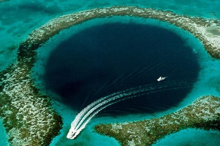
Great Blue Hole: The giant submarine sinkhole close to the coast of Belize. (USGS)
The Great Blue Hole is a renowned tourist destination and a world-class attraction for skilled recreational scuba divers. Located in the epicenter of the Lighthouse Reef, a small island around 100 kilometers away from Belize City, the Great Blue Hole is the name given to a large underwater sinkhole situated in the proximity of Belize’s coastal region.
The shape of the hole is circular, and it has an approximate diameter of 300 meters and a depth of 125 meters. Touted to be the world’s largest formation of such kind, it is noted as a component of the Barrier Reef Reserve System and a World Heritage Site, as declared by UNESCO. The development of the atolls is attributed to the settlement of limestone covered ridges in steps which may have begun 70 million years ago.
With the gradual increase in the level of the sea, the coral growth made its way upward creating several layers. Mentions of the atolls were found in records dating back to the 16th century, with the Great Blue Hole being on the receiving end of fame after its investigation by Jacques Cousteau in his ship, Calypso, in the 1970s.
Scuba diving at Great Blue Hole of Belize
The Belize Blue Hole is immensely popular with thousands of Scuba divers. It is a famous dive site, and one of the most beautiful and most advertised locations in Belize. Often described as a “bucket-list tick,” a dive in this sinkhole leaves a very powerful experience behind in the back of the diver’s minds.
Divers can observe the rich marine life in the region consisting of several species of fish, for example, the midnight parrotfish, and Caribbean reef shark. In the words of Ilya Rosado, a blogger, the dive is a wonderful experience but does not paint a colourful one. A dive in the hole has prerequisites which would not allow a new diver. The entire journey lasts approximately a day.

An Ariel photo of the Great Blue Hole from Hodoyoshi-1 satellite. (Axelspace Corporation)

Caye Caulker island is the launch off-site for the Great Blue Hole scuba divers. (Falco Ermert / Flickr)
The descent is in pure darkness, and the colours adopt a gloomy hue with the descent. At some point, the limestone wall becomes the only reference to the diver. Further into the dive, with a tad of luck, divers are able to witness coral reef sharks. The maximum allowed descent depth is around 100 ft, where they can see the incredible stalactites which date back several millennia.
The fame of this Blue Hole can also be attributed to the findings of Jacques Cousteau from the time he explored the hole. He declared it one of the best sites for scuba diving and his exploration provided the checkpoints. These investigations confirmed that the origin of the hole is typical karst limestone formations, which formed before rising in sea level of at least four times.
The ledges which are seen at different depths, such as 21 meters, 49 meters, and 91 meters, prove the existence of different stages. The Hole’s depth was measured by the Cambrian Foundation in 1997 as a part of their expedition. It was close to the initially measured depth (124 m/407 ft) at the deepest point. The name “The Great Blue Hole” is credited to a British diver and author called Ned Middleton, who first used the phrase in his book titled, “Ten Years Underwater”.
Enjoyed this article? Also, check out “The Lonar Lake: An Astronomical Marvel“.
Recommended Read:
1. Lonely Planet Belize (Country Travel Guide) | By Mara Vorhees
2. Ten Years Underwater | By Ned Middleton
Recommended Watch:
Great Blue Hole Of Belize | BBC
Recommended Visit:
The Great Blue Hole | Belize City
Fact Analysis:
STSTW Media strives to deliver accurate information through careful research. However, things can go wrong. If you find the above article inaccurate or biased, please let us know at [email protected].
RELATED
 June 15, 2019 Sarcastic Fringehead: Most Quarrelsome Fish That Has a Big Mouth
 January 18, 2020 Incredible Snake Island: One of the Most Uninhabitable Places in the World
 May 9, 2020 Elephant Beach: The Dazzling Sandy Beach in Andaman and Nicobar Islands Perfect for an Exotic Vacation
 September 19, 2018 Fairy Circles: The Systematic and Symmetrical Circular Arid Grass Formations
The post Great Blue Hole: Largest Underwater Sea Hole off the coast of Belize is a Diver’s Paradise appeared first on .
]]>The post Aurora Borealis & Aurora Australis: Nature’s Mesmerising Light-Show appeared first on .
]]>
Aurora at Fairbanks, United States. (Tommy Tang / Wikimedia Commons)
Aurora, the goddess of light in Roman mythologies, was also considered to be an embodiment of dawn. It is after her that the French philosopher, Petrus Gassendus, had coined the terms ‘Aurora Borealis’ and ‘Aurora Australis’, way back in the 16th century.
The Latin term ‘Aurora’, means ‘light’, while the terms ‘Borealis’ and ‘Australis’ indicate ‘Northern’ and ‘Southern’ respectively. As the name suggests, Aurora Borealis and Aurora Australis are lights that shine over the polar skies of the northern and southern hemisphere, respectively. They are visible in a specific polar belt in each of the hemispheres and appear as a ripple-like show of fluorescent colours in the dark night sky.
How are Aurora Borealis and Aurora Australis formed?
When there is an onset of storms in the sun’s surface, it releases a vast amount of solar charged particles, some of which tend to travel towards our planet. Once they come in contact with the earth’s atmosphere and magnetic field, a reaction takes place which hypes the atoms present in the scenario and lights them up. This further causes these magical lights to form and take shape.
When do Aurora Borealis and Aurora Australis occur?
Aurora Borealis and Aurora Australis are phenomena that depend entirely on solar activities and therefore aren’t very predictable. One can only be sure of them occurring about two hours before they actually occur. There are a few things that contribute to seeing the best, most beautiful exhibit of these lights, the most prominent one being the solar cycles. The sun has an 11-year cycle. In these 11 years, there are phases where the solar activities are extremely high, and then there are phases where they stoop really low. These changes in solar activity levels affect the formation of the lights drastically. The higher the solar activity, the more charged particles come Earth’s way, and the more intense the formation of lights is. On the other hand, when the situation counteracts and the solar activity is low, there are much lesser charged particles, and the aurora lights are comparatively dull. The year 2014 marked the most glorious of all aurora exhibits in the 11-year tenure of the cycle.

Aurora borealis. (pexels)
It is evident that the lights never stop occurring since there is always some amount of solar activity taking place. However, in order for human eyes to see the phenomena occur, an ideal time and setting is required. The view can, however, be experienced in its true magnificence, only when it is viewed in the dark. This automatically cancels the possibility of watching the aurora during the day. We must keep in mind that in the two poles, the days don’t go through the proper cycle of brightly lit daytime and dark nights. Rather, the duration of the ‘day’ depends entirely on the seasons. As far as the time of the year is concerned, winter is deemed the most ideal time to witness the Aurora Borealis and Aurora Australis. The winter season in the North is from April to August, and in the South, it is March to September.

Aurora from space. (NASA)
Why do we see Aurora Borealis and Aurora Australis only near the poles?
Aurora Borealis can only be seen at very high latitudes, beyond the Arctic Circle in the North. It can be best observed from areas such as Norway, Finland, Iceland, Alaska, Sweden, and even in some parts of Canada. Aurora Australis can be seen in the higher latitudes of the Southern Hemisphere, particularly in Antarctica, and in certain places of New Zealand. The Auroras can’t be seen everywhere, and the reason for the same lies in the way the Earth’s magnetic field acts. Since the magnetic fields of our planet are weaker near the Poles, the solar-charged particles find an easier entrance to the planet’s atmosphere through them. Consequently, the charged particles collide with the particles present in the atmosphere to form these beautiful displays of coloured lights.

Artist rendering of Solar Storm striking earth’s magnetic field. (NASA)
Do Aurora Borealis and Aurora Australis affect the earth in any way?
The solar energy charged particles that enter the earth are foreign materials. When they enter our atmosphere, they expand the same by a tiny margin. This disturbance disrupts the electromagnetic field, and affects the radio waves too, thus disturbing the transmission of information. The solar particles’ magnetic energy, when combined with the Earth’s magnetic energy, holds the potential of disrupting the proper functioning of electrical devices. In extreme cases, the lights might be a sign of the onset of a geomagnetic storm. Although such extremities have not been witnessed of late, and neither do they affect the onlookers as they occur such high up into the atmosphere. Geomagnetic storms hold the potential of wreaking havoc to the technological aspect of our planet, if not the environmental.
Related: What Would Happen if Solar Storm of 1859 Occurred Today?
What would happen if we didn’t have the Aurora lights?
As of yet, there isn’t any research or answers to this question. It will perhaps not affect the world much to not have the Aurora lights flickering above our heads. It would rather lead to the stabilization of the earth’s magnetic field and the atmosphere. Probably the usage of instruments that require electronic, magnetic and radio wave assistance will be easier as well. On the other hand, we will be missing out on nature’s own spectacular light show. The lights also stand as a record of the solar activities and it will become a lot tougher to document the same without the assistance of the Aurora phenomenon. Thus we can conclude, the eradication of this occurrence will perhaps not affect the Earth much. It will, however, conversely affect a lot of research, and there would be one less wonder for us to ponder about!
Aurora lights and mythology
The Aurora lights have had many mythological references and associations since mankind first took note of them. In many indigenous communities, the Northern and Southern lights are taken as the spirits of their ancestors that watch over them. Many believed it carries with it bad omens of some terrible calamity. In Norse mythology, the lights were taken to be proof of the existence of their gods, and were thus of religious importance to the Vikings.
For ages, this natural phenomenon has awed mankind, so much so that it has evolved into a literal hobby for some. Called ‘light chasing’, the activity is quite similar to that of bird watching. Here, however, instead of going to exotic jungles to watch pretty birds, one goes to Arctic countries, and the like to experience the Aurora lights. These lights are at once mysterious, stunningly beautiful, and a scientific marvel, depending on how you perceive them.
Enjoyed this article? Also, check out “Light Pillars, an Insight into Nature’s Spectacular Optical Phenomenon“.
Fact Analysis:
STSTW Media strives to deliver accurate information through careful research. However, things can go wrong. If you find the above article inaccurate or biased, please let us know at [email protected].
RELATED
 August 20, 2018 Noctilucent Clouds: Shining in the Summer Twilight Sky
 November 20, 2019 Solifugae: Unique Creatures That Are Neither True Scorpions Nor True Spiders
 July 29, 2019 Hoosier Cavefish: The Blind Cavefish from Indiana Named after Their NCAA Basketball League
- March 6, 2019 The Silky Anteater: The Nocturnal Dweller of the Tropical Rainforests
The post Aurora Borealis & Aurora Australis: Nature’s Mesmerising Light-Show appeared first on .
]]>The post Solifugae: Unique Creatures That Are Neither True Scorpions Nor True Spiders appeared first on .
]]>
Solifugae: A Sun Spider in Merida, Yucatan, Mexico. (Maximilian Paradiz / Flickr)
Solifugae are strange-looking creatures and, despite many studies, there is still much about their physical attributes and behaviours that we don’t know.
The name solifugae has Latin roots and means those that run away from the sun. It is a reference to their nocturnal habits. The creatures are also known as camel spiders, wind spiders, wind scorpions, sun scorpions, sun spiders, red romans, baardskeerder, and haarskeerders. The last two are Afrikaans terms for beard cutters and hair cutters.
Solifugae: Neither True Scorpions Nor True Spiders
Solifugae look like they might be a cross between spiders and scorpions, but, actually, they are a distinct species with over 1000 varieties in 153 genera. They are members of the Arachnida class and belong to the superorder Haplocnemata; they and the Pseudoscorpiones order are the only teo members of this superorder.
At first glance, though, solifugae do resemble spiders in physical appearance. The brownish-yellow or mottled solifugae body has two tagmata that consist of an abdomen known as opisthosoma and a prosoma, which is a combination of head and thorax and is also known as cephalothorax. There is no third tagma that forms a tail as is the case in scorpions, and they also do not have poison glands to produce venom.
Physical Appearance of Solifugae
The posterior opisthosoma has ten segments and the anterior prosoma has two segments. The prosoma has a prominent, arch-shaped plate—which is why these creatures are also known as camel spiders—and a pair of central simple eyes and a pair of lateral ones. There is no pedicel separating the prosoma and the opisthosoma as there is in spiders. Solifugae also do not have spinnerets like spiders and do not spin webs, and so do not need to have mobile abdomens like spiders do to use for their spinning activities.
There are six pairs of appendages that arise from the somites on the prosoma, but these are not all actual legs.
The first pair are the pedipalps that barely touch the ground while the solifugae are walking or running, and function more like antennae to detect things in their path. The five-segmented pedipalps have adhesive organs that are reversible and are used for climbing, defence, and to catch flying prey.

A sun spider in Circulo Montana, Arizona, USA. (ALAN SCHMIERER / Flickr)
Then there are the conspicuously large, distinctively curved chelicerae. Each of these have two articles that form powerful, crab-like pincers and, depending on the species, have a variable number of teeth. Using these chelicerae, solifugae can cut through hair, feathers, skin, and thin bones. They also use them to make rattling sounds to warn off enemies or attract potential mates.
Only the posterior three appendage pairs are real legs. They are each made up of seven segments. Two of these segments, the coxae and the trochanters, have fan-shaped organs known as malleoli on their undersides. The solifugae can turn the malleoli blades forward and backward, but the exact function of these organs remains unknown. The surmise is they may have a sensory use to detect prey, potential mates, threats, and ground vibrations. The other segmented parts of the real legs are femur, patella, tibia, metatarsus, and tarsus.
Using the real legs, the solifugae can attain speeds of 16 kilometres per hour, probably making them the fastest invertebrates on land.
Since the solifugae don’t have book lungs, they use their tracheal system to breath through three slit pairs that are located on the underside of the opisthosoma. Pseudoscorpiones also have the same breathing system.
Lengthwise, there are size variations in different solifugae species. Some mature specimens can grow up to 12 to 15 centimetres in length, while others are five to seven centimetres and some are under one centimetres.
Regions where Solifugae are found
While it is commonly assumed that solifugae are desert dwellers, they actually occur in a range of environments. Aside from deserts, semi-deserts, and scrubland, they occur in mountains, forests, and grasslands. They generally prefer warm temperate and tropical regions, and are widely found in Africa, Asia, the Americas, and Southern Europe. There are no solifugae in Antarctica, New Zealand, and Australia.
Diet of Solifugae
The diet of the solifugae principally consists of termites, beetles, and other small arthropods. They also feed on small lizards, rodents, snakes, birds, and other creatures. They are fast-moving and ferocious predators and most of them emerge out of their semi-permanent burrow only at night. They locate their preys with the pedipalps and use the chelicerae to grab the prey and cut it to pieces. They then liquefy the prey and use their pharynx to consume it.

The pedipalps of sun spider. (ALAN SCHMIERER / Flickr)
The solifugae are not dangerous to humans. They don’t have any venom to poison you with, and, for all their fabled speed, they are not going to outrun you. However, they can and will inflict painful cuts with their chelicerae if you get too close.
Lifecycle of Solifugae
The sexes are separate in the solifugae, and they reproduce by direct mating or by engaging in indirect sperm transfer. In the latter reproduction method, the male solifugae releases a spermatophore. He then uses his chelicerae turn the female solifugae on her back and inserts the spermatophore into her genital pore.
Since the solifugae are oviparous, the female solifugae will then, after a while, 50 to 200 eggs into a burrow. In some species, the female solifugae will eat extensively and fatten up prior to laying the eggs. She will then stand guard on the eggs and remain there, without eating, until they hatch.
The solifugae develop without metamorphosis. The postembryo that will emerge from the eggs will transform into nymphal instars and then develop into adult solifugae.
They have a lifespan of one to two years.
Enjoyed this article? Also, check out “Insects from Hell: Mecoptera, the Fly with a Scorpion Tail“.
Fact Analysis:
STSTW Media strives to deliver accurate information through careful research. However, things can go wrong. If you find the above article inaccurate or biased, please let us know at [email protected].
RELATED
- September 16, 2019 Maned Wolf: The Existential Crisis of Chrysocyon – the Golden Dog That Looks Like a Fox
- November 4, 2019 Goblin Shark: The Alien Shark of the Deep Sea, with a Slingshot Mouth
- October 4, 2019 The Extraordinary Exocoetidae – The Flying Fish of the Tropics and Subtropics
- April 8, 2019 The Manchineel Tree: One of the Most Toxic and Dangerous Tree in the World
The post Solifugae: Unique Creatures That Are Neither True Scorpions Nor True Spiders appeared first on .
]]>The post Bristlecone Pine: The Oldest Trees of Our Planet appeared first on .
]]>
Bristlecone Pine Forest in eastern California. (Rick Goldwaser / Flickr)
Before 2013, the oldest tree identified was Methuselah, a 4845 years old Bristlecone pine (Pinus longaeva), standing high in the White Mountain Ranges of California. But in 2013 researchers at the Tree-Ring Research group identified another P.longaeva, right there in the White Mountains, which was 5062 years old. P.longaeva is considered to be one of the longest living species on earth. The oldest bristlecone pine is also the oldest living individual of any species.
How have bristlecone pine trees managed to survive for so long?
These trees are found to inhabit harsh climatic and environmental conditions. Ironically they cannot easily survive under normal environmental conditions. They are beaten out by other trees and plants for food and survival in unpleasant conditions which makes their cultivation difficult in gardens. They grow in isolated groves mostly in rocky dolomitic soils in areas with practically no rainfall.
Like most trees found at the tree line, these trees tend to have slow growth due to conditions like dry soils, high winds blowing and cold temperatures with short growing seasons. These conditions work in favour of the pines because they eliminate other life-forms and also give their branches and needles the “unique appearance of a long bottle brush”. Their root system is highly branched and shallow and only a few large branches of root hold them down. They can easily survive extreme drought conditions not only because of shallow roots but also because of waxy needles with a thick cuticle that help retain water.
Another reason for their long lives is the extreme durability of their dense and resinous wood. This wood resists invasions by most potential pests and is said to be so strong that even after the tree dies, they stand on their roots for centuries without rotting.

Pinus longaeva during winter in Great Basin National Park, Nevada. (US NPS / Wikimedia Commons)
While they have lived a long life they are not regenerating or reproducing at a rate necessary for their sustenance and have been put International Union for Conservation of Nature (IUCN) red list.
The Bristlecone Pine trees have been blessed with every possible quality that had helped them survive for thousands of years as keepers of our history. Hope they do so for even longer into the future.
Enjoyed this article? Also, check out “The Pando Tree of Utah – The World’s Largest and Oldest Living Organism“.
Recommended Book:
Bristlecone Book: A Natural History of the World’s Oldest Trees | By Ronald M. Lanner
Recommended Visit:
Ancient Bristlecone Pine Forest | California
Fact Analysis:
STSTW Media strives to deliver accurate information through careful research. However, things can go wrong. If you find the above article inaccurate or biased, please let us know at [email protected].
RELATED
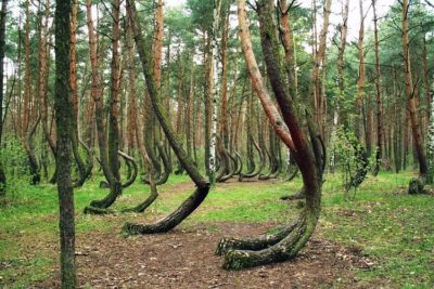 April 20, 2020 The Mysterious Crooked Forest of Poland
 May 23, 2018 Danxia Landform: China’s Rainbow Mountains
- April 25, 2020 Trigona Spinipes: The Combative Stingless Bee that Lives in Dung
- June 15, 2019 Sarcastic Fringehead: Most Quarrelsome Fish That Has a Big Mouth
The post Bristlecone Pine: The Oldest Trees of Our Planet appeared first on .
]]>The post Goblin Shark: The Alien Shark of the Deep Sea, with a Slingshot Mouth appeared first on .
]]>
Head of a goblin shark. (Dianne Bray / Museum Victoria)
Goblin Shark look like an alien, a character straight out of science fiction. Their dead bodies appear frightening, hence the name ‘goblin’. Goblin sharks pose no real threat to humans. Living at the depths of around 4265 feet (1300 m), they are a rare sight. Knowledge about them is limited to their accidental findings in fishing trawls.
First discovered in 1898
The Goblin shark (Mitsukurina owstoni), is also called “living fossil“ as it ceased to evolve some 70 million years ago. It thrived in deep and dark sea floors, like Mariana Trench, for millions of years. It has been caught, accidentally, from myriad regions of Atlantic, Pacific and Indian oceans. Goblin belongs to the shark family mitsukurinidae, which lived in the sea 125 million years ago. It was first noticed in 1898, off the Japan coast, as a surprise finds in a commercial fish load. In Japan, the fish is also called Mitsukuri shark.

Goblin shark or Mitsukurina owstoni. (Justin / Flickr)
Stretchable jaws are the characteristic feature
The goblin shark has a characteristic protrusible mouth. It can stretch its jaw forward to catch its prey and then retract it back under the snout. This act makes the fish look frightening. A long flat nose/snout covers the jaws. The skin is translucent. Hence the blood vessels are visible from outside and the fish appears pink in colour. They can camouflage with ease, as the red colour appears black in the deep sea. That keeps them safe – hidden from their enemies.
Uses mouth like a slingshot to catch prey
In the year 2008 and 2011, divers working with NHK (Naharkatiya), a Japanese television, captured 2 goblins and made live videos. That showcased their unique capacity to unhinge their jaws and stab them forward to catch its prey (Crustaceans, squids and fishes etc). This ‘slingshot feeding’ includes the fish mouth surging ahead of body line at a terrific speed of 3.1 meters per second. That way, the fish gets an instant thrust of 9.4 percent of her body length. If a human swimmer had this ability, his teeth would move a good 7 inches in front of his face. The protrusible jaws compensates for the hard swim in high-pressured deep waters, to overtake a prey swimming at a faster speed. This also ensures surety of kill in a food scarce zone.
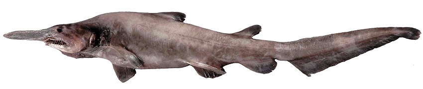
A juvenile goblin shark. (Dianne Bray / Museum Victoria)
Photo-sensors on snout search out the prey
The knack of shooting the mouth distinguishes goblin from other sharks. The long snout (rostrum) of the shark carries a special sensor which sense electric fields and helps in locating prey at depths where the sunlight can’t reach, hence visibility is poor. The mouth of the fish has rows of thin and long teeth, some visible even when the jaws are closed. Body length can go up to 10.5 feet (3.2 meters). Notably, half of a whole lot of shark species in general, are less than 3 feet long.

Distribution map for goblin shark. (Yzx / Wikimedia Commons)
Goblin shark reproduction
Goblin shark reproduces via internal fertilization. Post mating, the female retains fertilized eggs in her body. During the gestation period, the developing lives feed on the unfertilized eggs. After birth, the newborn takes to predation. Their uncertain and unreachable location in deep ocean precludes any possibility of catching them commercially or for research. Knowledge about them is based entirely on their accidental capture while hunting for other varieties of fish.
Nevertheless, the existential importance of the deep-sea sharks can’t be denied. Apart from awe inspiration for human creativity, sharks are key to nature’s food chain, ecotourism, and the study of genomes. Life on the seafloor can reveal how it survived the worst of living circumstances. Such a study can open new doors for the survival and the welfare of the human race.
Click here to view the footage of goblin shark.
Enjoyed this article? Also, check out “An Up-Close and Personal Encounter with the Alien-Like Pacific Barreleye Fish“.
Fact Analysis:
STSTW Media strives to deliver accurate information through careful research. However, things can go wrong. If you find the above article inaccurate or biased, please let us know at [email protected].
RELATED
- February 20, 2020 Greenland Shark: The Longest Living Vertebrates to Swim The Arctic Ocean
- October 4, 2019 The Extraordinary Exocoetidae – The Flying Fish of the Tropics and Subtropics
- November 20, 2019 Solifugae: Unique Creatures That Are Neither True Scorpions Nor True Spiders
- September 16, 2019 Maned Wolf: The Existential Crisis of Chrysocyon – the Golden Dog That Looks Like a Fox
The post Goblin Shark: The Alien Shark of the Deep Sea, with a Slingshot Mouth appeared first on .
]]>The post Champawat Tiger: The Killer of 436 Humans is a Case of Animal-Need Pitted against Human-Greed appeared first on .
]]>
The head of Champawat Tiger. (Nihal Neerrad S / Wikimedia Commons)
Today, the Asian Tigers are a threatened species with just about 3200 thriving units. The number was a lakh (hundred thousand) a century back. The most numerous subspecies, Bengal Tigers, is reduced to 2500 and is also endangered according to IUCN. Man’s itch for infrastructure development and professional hunting has led to this drastic depletion. Tigers are not the natural enemies of man, but may turn on him following injury, and the exigencies of living space. The story of the Champawat tiger, a Bengal tigress that killed 436 humans, is a classical example.
The killing started in Nepal and extended to Kumaon
In the 19th century British ruled India, a Bengal tigress in the Himalayan range of Western Nepal turned into a man-eater. A man of Tharu tribe from Rupal village was her first victim. Professional hunters were called and put on the mission to kill the tigress. But the tigress was too swift and cunning to be caught. Next, in an upscale measure, the army was put on job. Army gheraoed the tigress (who, post her death much later, would be named as Champawat Tiger), but she escaped by crossing over to an adjoining habitat.
Kumaon district, across river Sarda, became her new home, and a terror zone for the natives living there. For seven years, the tigress struck men women and children with brazen audacity, even during the day time, if the opportunity presented itself. An estimated 436 humans fell prey to the deviant wild cat.
Only hassled and handicapped tigers attack men
Tigers normally don’t attack humans for food. They do so only in some exceptional circumstances. In the case of Champawat tiger, it was a hunter’s bullet that failed to kill her but smashed her upper and lower right canines. This injury constrained her from catching its natural prey. And the pangs of hunger forced the tigress to an easier catch, the humans. Another contributing factor was the rampant deforestation done by the British government. The exercise done in the name of infrastructure development was a direct infringement on the living space of the wildlife.
Verily, a fight between man and nature
As man was busy asserting his power on nature, the Bengal tigress was out asserting her power on mankind. Best time for the kill was the day time, when men moved out for work. So, most of her attacks occurred during the day. Even those who rested in the 4 walls of their homes, weren’t spared. Human habitation became her food-spread which she walked into whenever hungry.
Surreptitious killings created mayhem
Ferocious canine teeth, brute power and the quick reflexes of a tiger can freeze any human with fear. The ears of a tiger can hear a wide range of frequencies from 0.2 kHz to 100 kHz, they also have a strong sense of smell. Ears can also rotate on base to catch sound from a particular direction. These endowments make the big cat a stealth killer. Time and again skilled hunters, police and military were engaged to kill the tigress, but to no avail. Orthodox and the God-fearing natives even started believing that it was some kind of a curse from the nether world. Gripped with fear, people stopped moving out of homes. Ironically, even homes weren’t safe. The tigress attacked people sleeping in huts, travelling on boats and even those who perched on trees.
Finally, the British administration couldn’t take it any longer. In the year 1907, the deputy commissioner of Nainital, Charles Henry Berthoud, was determined to do ‘something’. He went out to meet his friend, Jim Corbett.
Jim Corbett was tasked to kill the man-eater
Jim Corbett was a renowned hunter and a railroad worker of Irish lineage. Born and brought up in Kumaon hills, he had spent quality time with native hunters of Kaladhungi forests. Killing of a leopard at the age of 10 was his first landmark, and many more would follow. Berthoud wanted Jim to go after the Bengal tigress. Even though Jim had no hands-on experience of dealing with a man-eater, he agreed to give it a try. He didn’t have to wait for long to go ahead on the task. A fresh killing was reported just 5 days later. A woman astride a tree, plucking leaves for fodder, was pounced upon and killed. This happened in a town 60 miles away. Jim packed up, took six natives as helpers, and headed towards the town.
Village Champawat became the name and the nemesis
On reaching the destination, he saw villagers in a state of shock. As for the tigress, there were no signs of her. So, he decided to wait and watch. A nearby village, Champawat, was frequented by the tigress in the past. The village would go on to become the nemesis, as well as the enduring identity of the tigress as ‘Champawat tiger’. On the advice of the villagers, Jim moved towards this village and got the ultimate lead, a yet another kill. A 16-year-old girl was mauled by the tigress and dragged deep into the woods. The trail was marked by fresh blood. Jim followed the trail and found the victim’s skirt in a distant valley. In the near vicinity were seen scattered pieces of bones, and a severed human leg. Warm blood was still oozing from the leg. Obviously, the man-eater was somewhere near. The thought gave him a mix of hope and fear, and an alert Jim spent hours sitting in a hideout, his finger pressed to trigger. But the big cat eluded him, and he was forced to return.
Massive manpower was used in the final assault
On the day next, Jim reached the valley with a team of 300 villagers. The team spread out into a wall that forced Champawat tiger in a direction where Jim lay in wait. The human wall screamed, beat drums and used firearms to intimidate the animal. With a pounding heartbeat and loaded gun, Jim was now ready for a tryst with destiny. A tiger leaping with lightning speed would give him only a couple of seconds to take aim and shoot. Missing the aim would cost him life. So, for him, it was a matter of do-or-die.
The beast fell to the second round of firing
The moment of reckoning finally arrived. Jim saw some stripes emerge out of shadows. It was the tigress. Corbett fired a shot, which missed the mark. He fired again, this time it hit the animal. Third shot too was on target. But high on adrenaline, the big cat still surged for an attack. Out of ammunition, Jim ran for his life. Sprinting across the valley as fast as he could, he took a shotgun from a colleague, ran back to the hit-but-alive tiger, and fired a volley of bullets from 20 feet distance. With that, he called it a day.
Champawat Tiger made a world record
Death of the Bengal tigress was widely celebrated. But, for Jim Corbett, it was a solemn occasion. Death of the tiger weighed heavy on his mind even as there was relief and satisfaction of a job done. Post mortem findings revealed her broken canines, the prime reason for her turning into a man-eater. The tigress entered in Guinness Book of world records for killing the highest number of humans, i.e. 436. It is believed she may have killed more, as many cases may have gone unreported.
Many more man-eaters were put to death
Post the killing of the Champawat tiger, Jim Corbett was engaged in the extermination of other man-eating tigers too. The last man-eater he killed was in the year 1938, at 63 years of age. A celebrity, and bestselling author of 6 books, he was an animal lover and a committed conservationist at heart. The declining number of tiger population perturbed him even during his lifetime. So much so, he devoted the last 2 decades of his life for the protection of tiger species. Corbett national park at Nainital, Uttarakhand, committed to protecting the endangered Bengal tiger, is a fitting tribute to this outstanding naturalist, hunter, and lover of the wildlife.
Jim Corbett rooted for the conservation of wildlife
Tigers are “a large-hearted gentleman with boundless courage”, opined Jim. They turn man-eaters when wounded, and in some exceptional circumstances, he added. From the man-eating tigers in the past, to the threatened-with-extinction tigers at present, the time has come a full circle. The need of the hour is to conserve tigers at all cost. Otherwise, as Jim Corbett rightly said: if the tiger goes extinct, India will be poorer.
Enjoyed this article? Also, check out “Jim Corbett: A White Hunter Who Became Saviour of Tigers“.
Fact Analysis:
STSTW Media strives to deliver accurate information through careful research. However, things can go wrong. If you find the above article inaccurate or biased, please let us know at [email protected].
RELATED
 October 5, 2019 Jim Corbett: A White Hunter Who Became Saviour of Tigers
 August 1, 2019 Tiger Temple: A Clandestine Tiger-Breeding Facility Run by Monks
 July 3, 2019 The Bengal Famine of 1943: The Man-Made Famine That Killed Around 3 Million Indians
 February 6, 2019 Tipu’s Tiger: Tipu Sultan’s Macabre 18th Century Mechanical Toy That Doubled Up As a Pipe Organ
The post Champawat Tiger: The Killer of 436 Humans is a Case of Animal-Need Pitted against Human-Greed appeared first on .
]]>The post The Extraordinary Exocoetidae – The Flying Fish of the Tropics and Subtropics appeared first on .
]]>
Flying fish in Lakshadweep. (Mike Prince / Flickr)
Known commonly as flying fish, the Exocoetidae are oceanic fish that are widely found in the tropics and the subtropics. They are renowned for their ability to launch out of the water and glide in the air to escape predators. With their streamlined bodies and wing-like fins, these small fish can cover extensive distances, some of several thousand feet, while they are still air bound.
The Exocoetidae – flying fish
The word Exocoetidae comes from the Greek language and means “to lie down”. The ancient Greeks, who observed the fish leaping out of the water, either assumed that they left the ocean to sleep onshore or used ‘sleep’ as a simile for dying. Many of these flying fish leap so high that they often land on boat decks and, stranded thus, die there.
The Exocoetidae belong to the Actinopterygii Class of the Beloniformes Order and Exocoetoidei Suborder. There are 64 species of them that are grouped in four subfamilies—Exocoetinae, Fodiatorinae, Parexocoetinae, and Cypsellurinae. There are seven genera—Exocoetus, Fodiator, and Parexocoetus under the first three subfamilies, respectively, and Cheilopogon, Cypselurus, Hirundichthys, and Prognichthys under the Cypsellurinae subfamily.
While these fish inhabit all oceanic bodies, they appear to have a marked preference for tropical and subtropical regions. Also, they are mainly found in the epipelagic zone, which is the ocean’s upper layer and which extends down to a depth of around 656 feet. The sunlight that enters the ocean can reach down only as far as this layer, and that is why the epipelagic zone is where most of the marine life generally thrive.
The flying fish feed on plankton and other tiny marine creatures. In turn, they are prey to tuna, marlin, squid, porpoises, dolphins and other marine animals. While they leap out of the water to get away from these predators, it is not a very foolproof method of escape. Seagulls and other marine birds are always on the lookout for the Exocoetidae and swoop down to grab them in mid-air.
Physical features of the Exocoetidae
In size, the Exocoetidae are small, measuring from seven inches to up to 10 inches to 18 inches in length.
The reason the Exocoetidae are able to make such high leaps and glide over long distances is due to morphological features such as broad neural arches, a sturdy and well-developed vertebral column, and enlarged pectoral fins. Some species of flying fish also have enlarged pelvic fins to assist them better in flight. The fish’s torpedo-like body shape is also conducive for flight.

Flying fish mid-flight. (Roshan Kamath / Pexels)
The fish’s ligaments and connective tissues converge into the broad neural arches. These skeletal connections from the cranium to the vertebral column strengthen the vertebral column and confer a rigidity on it that is ultimately beneficial for the fish’s glided flight. It is similar to the aerodynamic principles that make flights possible for planes. With their bodies rigidly held, the Exocoetidae are able to lift out of the water and glide forward in the air faster.
As they glide, they spread their pectoral fins wide and the curved, wing-like shapes of these fins enable to increase their gliding time and also to take advantage of the air drafts created by the oceanic currents.
Do the Exocotidae really fly?
Flying fish don’t actually fly in the way birds do. They cannot flap their pectoral and pelvic fins while in air. What they do is propel themselves out of the water with a powerful leap. To make this leap, the Exocoetidae beats its tail very rapidly from side to side and uses the momentum to thrust out of the water surface. They then spread their pectoral fins wide in the air and use them to glide over the water surface.

Flying fish propelling itself forward by wagging its tail-fin left and right. (NOAA)
With these fins and their streamlined torpedo-like shapes, the Exocoetidae can generally cover distances of around 160 feet at heights of 20 feet over the ocean surface and at speeds of 70 kilometres per hour. If they manage to catch a favourable oceanic updraft, they are able to glide even further. Researchers have observed flying fish gliding for as far as 1300 feet.
There are various reasons why the Exocoetidae make these long glides. It may be to escape predators and, perhaps, also to move to newer feeding grounds in the shortest amount of time.
Flying fish as a delicacy
As mentioned earlier, flying fish are found in tropical and warm subtropical waters. Some of the countries in these regions include India, Bangladesh, Japan, Vietnam, Indonesia, Taiwan, China, Venezuela, and Barbados. In nearly all these countries, the Exocoetidae are fished and considered a culinary delicacy.
Commercial fishermen catch the fish by gillnetting and dipnetting. Some fishermen also catch the Exocoetidae with nets as the fish leap out of the waters. Another way to catch the Exocoetidae is by fishing on moonless nights using lights to attract the fish towards the fishing boats.
The fish is consumed in a variety of ways. In some areas, it is dried to preserve it and the dried fish is then used to make broth. The Japanese use the roe or eggs of the flying fish to make sushi; they call the roe tobiko. In Barbados, the locals use the flying fish to make a dish called cou-cou; it is the country’s national dish.

Fried flying fish served in a Japanese restaurant. (Miya / Wikimedia Commons)
The flying fish is also the national emblem of Barbados, and images of it can be found all over the island. The flying fish was once found so abundantly in the Atlantic Ocean where the island of Barbados is located that the country came to be known as the land of the flying fish. The Exocoetidae migrated regularly between the coral reefs of the Atlantic Ocean and Venezuela’s plankton-rich Orinoco River.
The numbers of Exocoetidae around Barbados have decreased drastically in recent times. Ever since the Bridgetown Habor opened, ship traffic has gone up in the area. The pollution caused by the ship fuel has had a negative impact on the surrounding coral reefs and this, in turn, has affected the fish population. Overfishing is another reason why the ocean waters no longer teem with Exocoetidae. You are more likely to see the fish near Tobago, which is around 220 kilometres away than around Barbados.
Interesting facts about the Exocoetidae
- An ancient species of flying fish, known as Potanichthys xingyiensis, existed during the Middle Triassic Period. That is, it lived sometime between 232 and 242 million years. Researchers, who studied the fossil of the Potanichthys xingyiensis, have concluded that it is not an ancestor of the present-day flying fish. The modern Exocoetidae evolved around 66 million years ago.
- In the early years of the 20th century, between 1900 to the late 1930s, aeronautical engineers studied the shape of the flying fish for possible use in designing aeroplanes.
- Exocet, an anti-ship missile that the French developed in the 1970s, is named after the Exocoetidae. After it is launched underwater, the missile breaks out of the water and glides over the water surface before hitting the target.
- Barbados and Trinidad and Tobago have been at loggerheads over the commercial fishing of the Exocoetidae.
- Flying fish can spend up to 42 seconds gliding in the air. The record for the longest flight is 45 seconds and was done on film by a flying fish off the coast of Yakushima Island in Japan. A Japanese television crew was on hand to record the event. There may be many more record-breakers in the ocean.
Enjoyed this article? Also, check out “Hoosier Cavefish: The Blind Cavefish from Indiana Named after Their NCAA Basketball League“.
Fact Analysis:
STSTW Media strives to deliver accurate information through careful research. However, things can go wrong. If you find the above article inaccurate or biased, please let us know at [email protected].
RELATED
- November 4, 2019 Goblin Shark: The Alien Shark of the Deep Sea, with a Slingshot Mouth
- November 20, 2019 Solifugae: Unique Creatures That Are Neither True Scorpions Nor True Spiders
- September 16, 2019 Maned Wolf: The Existential Crisis of Chrysocyon – the Golden Dog That Looks Like a Fox
- February 21, 2019 Lake Baikal: The World’s Deepest Lake That Holds 22-23% of the World’s Freshwater
The post The Extraordinary Exocoetidae – The Flying Fish of the Tropics and Subtropics appeared first on .
]]>The post Tsavo Man-Eaters: A Pair of Rogue Lions That Killed Nearly 135 People appeared first on .
]]>
Oil painting of Tsavo man-eaters by John Banovich. (Banovich Art / Wikimedia Commons)
The Tsavo Man-Eaters were a couple of lions that belonged to the Tsavo region, and were responsible for the death of several construction workers in the area. The pair of man-eating lions were infamous for their characteristic manner of attacking and killing people. They went on to attack and devour approximately 135 people, all of who were working on the Kenya-Uganda Railway, just within the span of a few months- in 1898 from March to December.
History of the Tsavo Man-Eaters
As far as history recalls, Tsavo lions have always been known to be man-eaters. While they are smaller than the Serengeti lions that are found to the west of Mount Kilimanjaro, Tsavo lions are more ferocious and known for their notorious deviancy. They have sparser to practically no manes because of the harsh environment they live in. A pride of Tsavo lions are usually smaller and consist of only one male having breeding rights and about 10 females.
In earlier times, when slave trading roads were developed from Tsavo to get to Mombasa for the Arabian slave caravans, quite often some of the slaves would die or be on the brink of death. In such cases, the slaves would be left behind, and would become prey to scavengers. It is believed that these instances were responsible for giving the Tsavo lions a taste of human flesh, which would later become a serious problem in the 19th century.
Samuel Kasiki, who is the deputy director of the Biodiversity Research and Monitoring, and is associated with the Kenya Wildlife Service said,
“The death rate was high … the bodies of slaves who died or were dying were left… So the lions may have gotten their taste for human flesh by eating the corpses.”
The reign of terror of the Tsavo Man-Eaters
In March 1898, the British Lieutenant Colonel General John Henry Patterson visited Kenya, with several Indian workers accompanying him. He intended to build a bridge over the Tsavo River, which was supposed to be a part of the Kenya- Uganda Railway Project.

Lieutenant-Colonel John Henry Patterson. (Wikimedia Commons)
According to Bruce Patterson (not a relative of John Henry Patterson), who wrote a book called ‘The Lions of Tsavo’, the project was doomed from the start. He wrote in his book, “Few of the men at the railhead knew that the name itself was a warning.” Tsavo meant ‘place of slaughter’ in their native language. It was considered to be a bad omen and was a reference to the several killings by the people of the Masai tribe who would attack tribes that were much weaker than them.
Soon after Lt. Col. Patterson and his workers arrived, it came to their notice that their porter had gone missing. A search was conducted almost immediately when the people came across the devoured and mutilated body of the porter.
In his book “The Man-eaters of Tsavo”, 1907, Lt. Col. Patterson wrote about the terrible sight. He wrote,
“On reaching the spot … a dreadful spectacle presented itself … covered with blood and morsels of flesh and bones”.
This was an account of his first encounter with the Tsavo Man-Eaters. Then and there, he had resolved to rid the region of these vicious creatures no matter the cost.
Patterson had experience hunting tigers back when he was in India, and was well-suited to put a stop to the notorious lions and their activities. He came up with various methods to try and put a stop to the two man-eating Tsavo lions. Patterson put up barriers of thorns, lit bonfires at night, and became extremely vigilant and gave orders for curfews. However, none of it really yielded any results, and almost as though it had provoked the deadly duo, the attacks only got more gruesome.
The lions would attack the camps of the workers at night, and drag them out of their tents to devour them. According to most reports, the ferocious predators were believed to have killed at least 135 people that year. However, the official company reports say that the official number of deaths is close to 40.
One of the people who were working on the railway project wrote, “Hundreds of men fell victims to these savage creatures … left not a trace behind them.” The two lions were named ‘Darkness’ and ‘Ghost’ because of their stealthy nature while hunting their prey at the dark hours of the night.
The end of the Tsavo Man-Eaters

Colonel Patterson with the first of the two Tsavo man-eaters after being shot. (Field Museum / Wikimedia Commons)
Despite all his efforts, it took Lieutenant Colonel Patterson several months to kill the two Tsavo lions that had been on a rampage. Patterson killed the first lion on December 9, 1898, and it took him another three weeks to hunt and kill the second one.

The second Tsavo lion after being shot. (Wikimedia Commons)
Upon the death of the lions, it was found that the two lions had gone rogue and did not belong to any particular pride. Both of them had no manes, and each of them was a little more than nine feet long. However, in comparison to the other lions in the area, the two predators were much larger in size. This may have been due to the excessive amount of food that they had gained access to.
With the looming threat of the lion attacks vanishing, the workers resumed the project and the bridge was completed in February 1899. Patterson was hailed as a hero, and he kept the skin and the skulls of the two lions. He later sold them for $5,000 to the Field Museum of Natural History in Chicago, where they were stuffed and put on display for visitors, and continues to remain there till date.

Tsavo Man-Eater on display in Field Museum of Natural History. (Superx308 / Wikimedia Commons)
Modern research and depiction in popular culture
According to Bruce Patterson, who is a zoologist at the museum in Chicago, several chemical tests have been conducted which revealed that the lions had eaten exclusively human flesh for several months before they had been killed.
However, there is not much difference between the Tsavo lions of present-day and the lions from the 19th century. Patterson said that they attack people for the same reason as before – “our encroachment into what was once the territory of lions.” Modern research has, however, pointed out that the reason behind the man-eating tendencies of the Tsavo Man-Eaters could have been due to their poor dental health. Sporting multiple injuries within their maw, it must have been difficult for them to catch their regular prey in the wild, and thus resorted to pouncing on the much-less-agile and often less alert and readily available humans in their territory.

The skulls of the infamous Tsavo Man-Eaters. (Superx308 / Wikimedia Commons)
The stories of the two Tsavo man-eaters have been the basis for many films including, ‘Men Against the Sun’ (1952), ‘Killers of Kilimanjaro’ (1956), as well as ‘The Ghost and the Darkness’ (1996).
Enjoyed this article? Also, check out “Mapogo Lions: The Six Legendary Lions That Meant ‘Bloody’ Business in Their Quest for Dominance“.
Fact Analysis:
STSTW Media strives to deliver accurate information through careful research. However, things can go wrong. If you find the above article inaccurate or biased, please let us know at [email protected].
Recommended Read:
The Man-Eaters of Tsavo | By John Henry Patterson
RELATED
 August 17, 2019 Euphrates River: A Dying River that Birthed One of the Oldest Civilisations
- January 31, 2020 Angel Oak: The Magnificent Giant Live Oak of Charleston
- September 16, 2019 Maned Wolf: The Existential Crisis of Chrysocyon – the Golden Dog That Looks Like a Fox
 October 11, 2019 Champawat Tiger: The Killer of 436 Humans is a Case of Animal-Need Pitted against Human-Greed
The post Tsavo Man-Eaters: A Pair of Rogue Lions That Killed Nearly 135 People appeared first on .
]]>The post Maned Wolf: The Existential Crisis of Chrysocyon – the Golden Dog That Looks Like a Fox appeared first on .
]]>
Maned wolf. (Max Pixel)
Listed as near threatened, the maned Wolf (Chrysocyon brachyurus) a carnivore of Canidae family is found in the forests and grasslands of Southern America, Argentina, Brazil, Bolivia, Paraguay, and Peru. It does have a mane but doesn’t look like a wolf. A fox look- alike, it isn’t a fox either. It is a unique creature, just one surviving species of the genus Chrysocyon.

The maned wolf is also known for its disproportionately looking long legs. (Tambako The Jaguar / Flickr)
Their uniqueness is a mixed blessing
A healthy adult can weigh between 20-25 Kg and measure 3 feet high in standing position, the animal has thick red skin loosely attached to the body frame. Long black hair on the nape and back make for a waving hair tuft, hence the name maned wolf. The hair on other parts of the body range from red, yellowish to brown, giving an overall impression of golden colour. Genus Chrysocyon, in the Greek language, means a golden-dog.

A maned wolf at Beardsley Zoo. (Sage Ross / Wikipedia Commons)
Raising of hair gives puffy plumpness to the animal and helps it scare the enemy in crisis situations. Ironically, being the largest sized animal of the Canidae family makes it stand-out and hounded by other members of the family like jackals and stray dogs. Genetic studies have shown that mane wolf descended from a large-bodied mammal the ice age.
Diet of the maned wolf
Maned wolf has a shorttail. The species name brachyurus means ‘short tail’. It measures 25-45 cm and is white-haired towards the distal end. White colour is also around chin and muzzle. A denture is a mix of carnivore and herbivore pattern; sharp canines of the carnivores and flat grinding molars of the herbivores. Animal, thus, is omnivorous. Half of its food intake is animal flesh and other half is fruits and vegetables. It preys on reptiles, small animals and birds- including poultry. It moves cautiously in the long grass and then pounces on prey with agility. A few bites later the prey is swallowed down. Lobeira, an apple-like fruit is animal’s staple food. This fruit also protects it from the kidney worms. Other vegetarian picks include sugarcane, roots, and fruits available in the habitat.

Lobeira, also known as wolf’s plant. (Evaldo Resende / Wikimedia Commons)
Demarcates its living range with excreta-stench
The animal lives solo or in monogamous pairs in about 10 square mile area of its natural habitat. The habitat is open grasslands with or without a sprinkle of trees and bushes. They also thrive well near swamp, rivers and forests. A peculiar stench of their urine and faeces demarcates their territorial holding. Based on the sharp smell of excreta, the other name for the animal is “skunk wolf”. The home-area of the living range is zealously guarded against intruders. They don’t howl like wolves, nor live in packs, but bark loudly to communicate with fellow animals and warn others to keep off their dominion zone. They have sharp ears which can rotate on base to catch sounds coming from different directions.
Good jumper and dodger, but a bad runner
Maned wolf has a peculiar wobbly gait. As it moves, the bodyweight is borne on two legs of the same side. The other two legs move together to create forward motion. Like the undulating move of a giraffe. In full gallop, the stilt-like hind legs are pushed clear ahead of the forelegs. Peculiar configuration of legs enables the animal to jump high and long in a jiffy. However, it is not a good runner and doesn’t chase its prey. Rather, it beguiles and shocks the target with a sudden move. Being a poor runner in a straight line, it is easily hunted down by its enemies. Generally, it gets along well with other species of the habitat. It is shy facing a man, who it would avoid at all cost. The animal has an average life expectancy of about 6.5 years with a maximum lifespan reaching up to 12-15 years.
Killed by man for medicine and mental peace
What has made this docile life near-threatened? One is human greed. Many believe body parts of maned wolf can be used as medicines as well as a good-luck charm. Then, many believe, falsely of course, that they harm their domestic livestock. These assumptions led to their wanton killing. The animal’s inability to reproduce fast and plentifully is another drag. Females have just one oestrus (heat period in which it allows male to mount for sexual reproduction) which lasts for about 5 days. One to five number of babies are delivered after a gestation period of 65 days. Thus one pregnancy adds an average of only 2.5 young ones to the population. Both the male and the female take care of their young ones. After one month of suckling, the newborn live off the food regurgitated from the mother’s mouth.

Young maned wolf playing. (Tambako The Jaguar / Flickr)
Paul Hawken rightly said that whereas the biological diversity is messy and noisy, extinction is silent. The only voice against extinction can be the human voice. And it ought to be raised for this lone surviving species of the golden-dog genus.
Enjoyed this article? You would also love “Hoatzin Reptile Bird: A Dinosaur-Like Bird with the Digestive System of a Cow“.
Special thanks to Tambako The Jaguar for releasing the photos of the maned wolf in creative commons.
Fact Analysis:
STSTW Media strives to deliver accurate information through careful research. However, things can go wrong. If you find the above article inaccurate or biased, please let us know at [email protected].
RELATED
- November 20, 2019 Solifugae: Unique Creatures That Are Neither True Scorpions Nor True Spiders
- November 4, 2019 Goblin Shark: The Alien Shark of the Deep Sea, with a Slingshot Mouth
- October 4, 2019 The Extraordinary Exocoetidae – The Flying Fish of the Tropics and Subtropics
- April 25, 2020 Trigona Spinipes: The Combative Stingless Bee that Lives in Dung
The post Maned Wolf: The Existential Crisis of Chrysocyon – the Golden Dog That Looks Like a Fox appeared first on .
]]>The post Hoatzin Reptile Bird: A Dinosaur-Like Bird with the Digestive System of a Cow appeared first on .
]]>
Hoatzin in Peru. (Francesco Veronesi / Flickr)
The Hoatzin Reptile Bird or Opisthocomus hoazin is a species of tropical bird that is found exclusively in the mangrove forests and swamps of the Amazon and Orinoco basins in South America. This species is generally found in riparian zones – which are large areas that form the interface between rivers and land.
The reptile bird is the only living member of the genus Opisthocomus. Interestingly, this genus is the only living genus of the family Opisthocomidae. Taxonomists and naturalists have been debating the status of this particular family for decades and thus its classification is still unclear. Colloquial names for the Hoatzin include reptile bird, stinkbird, skunk bird and Canje Pheasant.
Description
The Hoatzin Reptile Bird is roughly the same size as a common pheasant. On average, it is 65 cm long and has a long neck. Like all pheasants, the Hoatzin too has a small head.

Opisthocomus hoazin. (Vince Smith / Flickr)
The bird has a large crest on top of its head which is reddish-brown in colour. This crest is one of its most striking features. Also, the Greek word Opisthocomus means “wearing long hair behind”, which is a clear reference to the bird’s stunning crest. The Hoatzin also has a featherless face and scarlet eyes. It has a long brown tail which is tipped with ochre brown. The underparts of the bird are the same sooty brown colour. The mantle, nape and the wing coverts of the reptile bird are all streaked with the same ochre brown or buff colour.
Characteristics and behaviour
The Hoatzin Reptile Bird is a herbivorous bird and prefers to eat leaves, flowers and fruits. Thus, scientists have classified it as a folivore. Since the Hoatzin lives in a riparian and swampy habitat, it has an ample bounty of food. The bird is known to clamber between branches in search of its food.
The Hoatzin has a very unusual digestive system as it has an enlarged ‘crop’, which is an expanded thin-walled section of the bird’s alimentary canal. The function of this crop is the storage and fermentation of vegetable matter that is ingested by the bird. The digestive system of the Hoatzin Reptile Bird is similar to the one present in ruminant mammals such as cows and goats. The bird has a leathery bump on the bottom of its crop which helps in balancing. Initially, it was assumed that the Hoatzin could eat only arum and mangrove leaves. But gradual observation has shown that these birds also consume the leaves of more than fifty species of Amazonian vegetation. According to a Venezuelan study, the Hoatzin’s diet consists of 82% leaves, 10% flowers and 8% fruits.
The fermentation of vegetable matter in the bird’s body gives the bird its characteristic foul odour. This is the reason behind its colloquial names “Stinkbird” and “Skunk Bird”. This bird is also very noisy and makes a variety of raucous sounds to communicate and mark territory. Hoarse calls, croaks, groans, hisses, and grunts are used by this species to communicate, along with body movements such as spreading of the wings.
Discovery of the Hoatzin
The Hoatzin Reptile Bird was first discovered and described by the German zoologist Phillip Statius Muller in 1776. Professor Muller was a famed naturalist, ornithologist and entomologist who described a large number of undiscovered tropical species. The distinctive nature of the hoatzin has been the cause of many debates regarding its taxonomy, and scientists are divided in opinion regarding its relationship with other avian species.
Its uniqueness has caused scientists to assign the bird its very own family and genus. A genome sequencing study that was published in 2012 placed the Hoatzin as the sister taxon of a clade that also includes cranes (Gruiformes) and plovers (Charadriiformes). Comprehensive genetic research that was conducted in 2015 established that the Hoatzin is the last extant species of a line of avian species that branched off around 64 million years ago. This is the same time-period when the non-avian dinosaurs were killed off in a major extinction event.
Breeding habits
The Hoatzin bird breeds seasonally and generally does so during the monsoon season. As the rainy season occurs at different times in the different parts of South America, they tend to breed according to the season in the region it is residing in. These birds are very sociable and nest in small colonies.
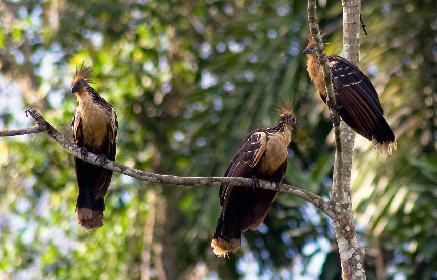
Hoatzins sitting on a branch. (Ricardo Sánchez / Flickr)
The females lay two or three eggs in nests that are placed on trees hanging over the water. Hoatzin chicks are unique because they are born with two claws on each wing. Immediately after birth, the chicks can use these claws to walk around on the branches without falling into the water. The chicks are fed regurgitated fermented vegetable matter by their parents.
Relationship with humans

Hoatzin Bird. (The Next Gen ScientistT / Flickr)
The Hoatzin birds are visually striking and beautiful because of their rich and vivid plumage. Additionally, it is unwary and cannot fly very well. The Hoatzin birds, however, are not hunted for game because of their objectionable odour. Their meat is also said to have a very bad taste. As a result, it is a relatively thriving species as it is usually left alone by humans. At present, the biggest threat to the Hoatzin birds is the loss of habitat caused by the deforestation of the Amazonian rainforest. If the swamps and marshes of South America continue to disappear, the bird could be in a lot more danger.
The Amazonian Basin boasts of some of the richest biodiversity available on the entire planet. The Hoatzin is one of the most interesting endemic species that can be found in these tropical rainforests of South America. The Hoatzin Reptile Bird is also of great taxonomic significance as its taxonomy has been argued and debated by naturalists for many years.
Enjoyed this article? Also, check out “An Up-Close and Personal Encounter with the Alien-Like Pacific Barreleye Fish“.
Fact Analysis:
STSTW Media strives to deliver accurate information through careful research. However, things can go wrong. If you find the above article inaccurate or biased, please let us know at [email protected].
 Recommended Read:
Handbook of the Birds of the World – Volume 16
Genre:
Non-fiction > Nature & Ecology
RELATED
 March 31, 2019 The Cano Cristales: Colombia’s Extraordinary River of Five Colors
 December 14, 2018 Vadoma: Tribe Famous for their Ostrich Foot Syndrome
- April 20, 2019 Forest Fire: Birds Deliberately Setting Forests on Fire to Flush Out Prey
- February 20, 2020 Greenland Shark: The Longest Living Vertebrates to Swim The Arctic Ocean
The post Hoatzin Reptile Bird: A Dinosaur-Like Bird with the Digestive System of a Cow appeared first on .
]]>The post Reynisfjara: The Black Sand Beach that Looks Straight out of a Gothic Novel appeared first on .
]]>
Reynisfjara black-sand beach, Iceland. (Serge / Flickr)
Reynisfjara quite literally means ‘Reynir’s beach’. The Black Sand Beach was named after Reynir, a wealthy man from Norway who had settled in the region back in the 18th century.
Most beaches have white sand, and they are formed due to the corrosion and breaking down of light coloured minerals, rocks, and stones. The beaches form when these tiny sand particles are washed away from the parent rock by the oceans and deposited on the edges over the years. Akin to white sand beaches, black sand beaches actually form in a very similar way, but the source of the sand particles are volcanic rocks. The rivers and streams help in cutting and corroding the volcanic rocks. As they gradually reach the ocean, the strong currents do the rest of the work and granulate them further. The sand grains get sediment on the beach as each wave hits the shore. There are also certain rare instances when the lava directly hits the ocean, and upon the sudden change of temperature, erupt into multiple sharp shards. These shards thereafter go through the same process of granulation and meet their inevitable fate of becoming sand.

A volcanic rock on the beach. (Serge / Flickr)
The sand is almost always pitch black in appearance. This is because of the fact that it is located in one of the wettest and heavy-perspiration areas of Iceland. Since it’s always raining and foggy in the area, the sand doesn’t get a chance to dry up and takes a greyish look to it.

The black sand of Reynisfjara. (Callie Reed / Flickr)
Caves and columns
The beach has multiple facets that add up to its value and appeal. Apart from the beautiful black sand, that contrasts with the pearly foam from the ocean the area is also home to many active and dormant volcanoes. In fact, most of Reynisfjara Beach’s physical attributes are a contribution of these volcanoes itself. One of the most famous and photogenic areas of this beach is the Gardar, an area filled with multiple columns that are closely packed. These structures are mostly made of Basalt and other volcanic rocks. The fractures form as a result of instant cooling down of the magma, as the outside shell cools instantly, but the insides take a much longer time. Upon the gradual cooling of the core, the outside surface becomes ridged and fractured, that give it the appearance of closely packed columns on the sea bed.


Natural pillar-like formation at Reynisfjara. (dconvertini / Flickr)
There are natural caves on the Beach that have been carved out by the sea. The ferocious tides and currents of the Atlantic Ocean managed to corrode the big rocks in such a way that it had formed into beautiful caves.
Fauna at the Reynisfjara
As mentioned previously, Reynisfjara Beach has formed off volcanic ashes and rock particles for the most part, and consequently, there is a scarcity of flora and fauna in this region. There are, however, some traces of animal life in that area. Birds are the most abundant of creatures that live in this area, making nests on the top of the hills. Puffins are quite a common sight in the region. Apart from this, and there is the usual abundance of sea creatures that thrive in the frigid Atlantic waters.
Is the Reynisfjara beach dangerous?
Owing to its geographic location, this Beach has proved fatal to many tourists. The extreme currents and tides of the Atlantic Ocean, coupled with the sudden drop of height, make this an extremely dangerous beach. Tourists are under strict surveillance and have been advised against going too close to the ocean.
Elves and trolls: Folklore around the Reynisfjara
The Reynisfjara Beach with its rare and mesmerizing scenery has left many people awestruck and intrigued, and it is needless to say that there are folklores built around it.
Some of the most interesting ones are those about trolls and elves. It is believed that one time, a few trolls had attempted to pull a ship ashore, but they did not realise that the sun was coming up. Engrossed in trying to pull the ship ashore, they worked till dawn, and the sun came up. As the sun touched their skin, they turned to stones and became the stones that we now see in Gardar. There have been stories built around elves as well, who had somehow turned into the rugged basalt columns on the Beach. These stories have become an intrinsic part of the local folklore and have been passed down the generations.
Filming location
Reynisfjara Beach was used as a filming location in the famous HBO show, Game of Thrones. The world presents us with a host of marvellous natural creations and mesmerising scenes- from the Pink Lake of Australia (Lake Spenser) whose salt content makes it look like it is filled with strawberries, to the Reynisfjara Beach with its inky black sands. The Beach manages to leave all its visitors awestruck, acting as a stunning amphitheatre to host the performance presented by the roaring oceans.
Enjoyed this article? Also, check out “Playa de Gulpiyuri: The Tiny Beach in the Principality of Asturias in Spain.”
Fact Analysis:
STSTW Media strives to deliver accurate information through careful research. However, things can go wrong. If you find the above article inaccurate or biased, please let us know at [email protected].
RELATED
 July 6, 2019 Playa de Gulpiyuri: The Tiny Beach in the Principality of Asturias in Spain
- February 5, 2019 White Sands National Monument: Ace Military Testing Area and an Astounding Tourist Destination
 June 1, 2020 The Clermont-Ferrand Cathedral: A Beautiful Gothic Structure Made of Black Lava Stone
- March 2, 2019 Wave Rock: Where a Massive Prehistoric Wave, Just About to Break, is Etched Permanently in Stone
The post Reynisfjara: The Black Sand Beach that Looks Straight out of a Gothic Novel appeared first on .
]]>The post Euphrates River: A Dying River that Birthed One of the Oldest Civilisations appeared first on .
]]>
The town of Halfefi, a small farming district on the east bank of Euphrates River, Turkey. (Bernard Gagnon / Wikimedia Commons)
The Euphrates River, along with the river Tigris, are the two greatest rivers in an area that was the cradle of ancient Mesopotamian civilization. Together, the two rivers form a great river system in the Middle East. The Euphrates River is one of the most historically important and longest rivers of West Asia.
Origin of name
While there has been a lot of conjecture about the origin of the name of Euphrates, many believe that the name may have actually been of Kurdish origin. The Kurdish word fererehat means “wide flowing water”. A newer derivative of the same is believed to be “Ferat”. Another group of scholars is of the opinion that the word has its origins in Old Persian, where Ufratu means “good to cross over”. The Sumerian and Akkadian names for the Euphrates make the Indo-European etymology uncertain.
The formation and path of the Euphrates River
As mentioned previously, the Euphrates River is the longest river in the south-western region of Asia and covers a length of 2800 km. Along with the Tigris River; these two rivers form the Tigris –Euphrates River System. The river originates in Eastern Turkey where it is formed by the confluence of the rivers Murat and Karasu that are found in the Armenian Highlands. It flows through the Taurus Mountains to the Syrian Plateau and then through western and central Iraq. Here, it joins the Tigris River and continues flowing as the Shatt -Al -Arab, and empties into the Persian Gulf.
Three rivers that rise in the foothills of the Taurus Mountains in Syria, along the Syro–Turkish border, add their water to the Euphrates. They are the Sajur, the Balikh, and the Khabur. Although these rivers comparatively add little water to the river, they are the only natural tributaries of the Euphrates. Once the river enters Iraq, there are only a handful of canals that exist which connect the Euphrates basin and the Tigris basin.
Historical importance

Water wheels of Ajmiyeh, on the Euphrates near Rawa, and Ana, in Mesopotamia (present-day Iraq). Circa 1911. (Gertrude Bell)
Dating from approximately the 4th millennium BC, the Euphrates was the source of water that led to the birth of the first civilization in Sumer. Several ancient cities were located on or near the riverside, including Eridu, Mari, Nippur, Sippar, Shuruppak, Uruk and Ur. It is also one of the two rivers from where Mesopotamia draws its name as the “Land between the Rivers”.
In ancient times, the river valley was heavily irrigated which formed the centres for the Babylonian and Assyrian empires in later years. For several hundreds of years, the Euphrates River formed the eastern limit to the control of Egyptian and Roman Empires, as well as the western regions of the Persian Empire. The Battle of Karbala is said to have taken place in 680 AD near the banks of this river.
After the First World War, the Ottoman Empire was partitioned when the Southwest Asian borders were redrawn in the Treaty of Lausanne (1923). According to this treaty, the three ‘riparian states’ of the Euphrates River, indicating Turkey, France (mandate of Syria) and the United Kingdom (mandate of Iraq), were supposed to reach a mutual conclusion about the use of the water of the river, as well as any constructions of a hydraulic installation. Turkey and Iraq signed an agreement in 1946 which gave Iraq the power to construct dams on Turkish land and control the flow of the Euphrates. The agreement also stated that Turkey had to report Iraq about any hydraulic changes that it made on the river system of the Tigris-Euphrates.
Climate, vegetation and natural history of the Euphrates River
To the north of the Persian Gulf lies the huge floodplain of the Karun, Tigris and Euphrates rivers that have marshes, permanent lakes and forests. The climate in this subtropical area is hot and dry. The areas around the Tigris and the Euphrates are extremely fertile.
There has been a constant decrease in the annual rainfall which determines the type of vegetation that the area can support. The river flows through several vegetation zones that are found in this region. When the Euphrates flows through the southeast Turkish mountains and the foothills in the south, ‘xeric woodland’ is observed. The most plant species include oaks, pistachio trees, rose plants and plum plants. There are several wild varieties of cereals that are found like, oats, rye, emmer wheat and einkorn wheat. To the south of this, the Euphrates flows through a steppe landscape which is characterised by plant species like white wormwood and Chenopodiaceae.
According to research, the Euphrates Valley probably supported a riverine forest, and significant features of this forest comprise of the Oriental plane, the Euphrates poplar, the Tamarisk, the ash and several other wetland plants.
Several animals like the gazelle, onager, and the Arabian ostrich (now extinct) are believed to have been inhabitants of the steppes on the border of the Euphrates valley. The valley itself is believed to have been home to the wild boar. Other animals include the golden jackal, the gray wolf, the red fox, the leopard as well as the lion. In the mountains of southeast Turkey, the Syrian brown bear can also be found.
The Euphrates River in the Bible
According to the Bible, in Genesis 2:14 there are four rivers that flow from the Garden of Eden. The four rivers are the Pishon, the Gihon, the Tigris and the Euphrates. It is believed that the Euphrates River marked one of the boundaries of the “Promised Land” by God to the descendants of Abraham- Jacob, Isaac, and their children. According to the Bible for Hebrews, the Euphrates is simply referred to as “The River”.
Several religious texts have prophecies in them. Similarly, there is a prophecy in the Book of Revelation about the Euphrates River. According to the prophecy, in the ‘near future, the Potamos Euphrates… will dry up in preparation for the Battle of Armageddon’… “And the sixth angel poured out his vial upon the great river Euphrates; and the water thereof was dried up….”
Islamic prophecies about the Euphrates River
Like the Book of Revelation in Christianity, there are Islamic prophecies in some of the hadiths of Prophet Muhammad that also suggest that the Euphrates River will dry up. It also says that once the river dries up, it will reveal unknown treasures that will eventually lead to conflict and war across the world.
The River Euphrates under threat

Tigris-Euphrates Basin in 2006. (NASA)
Tigris-Euphrates Basin in 2009. (NASA)
Due to extreme weather conditions and excessive pollution, there is barely enough water to be able to float a canoe properly. According to the Iraqi River Police, there is garbage in the water which has turned the river a murky green and the waterway sluggish. According to recent satellite study, the Tigris – Euphrates basin has a groundwater depletion rate higher than any other place on the planet, except India. Due to the high rate of global warming in the world, it is believed that an environmental disaster is likely to be encountered as the Euphrates is drying up.
Enjoyed this article? Also, check out “Pamukkale: The Cotton Castle in a Mess of Limestone and Healing Waters“.
Fact Analysis:
STSTW Media strives to deliver accurate information through careful research. However, things can go wrong. If you find the above article inaccurate or biased, please let us know at [email protected].
 Recommended Read:
Euphrates and Tigris, Mesopotamian Ecology and Destiny | By J. Rzóska (Editor)
Genre:
Non-fiction > Life Sciences > Ecology
RELATED
 June 17, 2019 Pamukkale: The Cotton Castle in a Mess of Limestone and Healing Waters
- January 8, 2019 Proboscis Monkey: The Rare Borneo Monkey Species with an Unusually Long Nose to Lure Its Females
 September 30, 2019 Tsavo Man-Eaters: A Pair of Rogue Lions That Killed Nearly 135 People
- January 15, 2019 Pink Lakes: Where Rose-Tinted Lakes Surrounded By Lush Greenery Are Truly a Sight to Behold
The post Euphrates River: A Dying River that Birthed One of the Oldest Civilisations appeared first on .
]]>The post Zebroid: Strange Equine Hybrids That Make Their Parentage Shine appeared first on .
]]>
A hebra (a cross between horse stallion and a zebra mare) in zoo Safaripark Stukenbrock, Germany. (Christine und David Schmitt / Flickr)
To understand what a Zebroid is, it is important to have knowledge of Equines. A specific genus of mammals of the family Equidae is referred to as Equus or the Equines. This family comprises of seven different species that include horses, donkeys and zebras. Consequently, a Zebroid is an offspring that results from a cross of a zebra with an equine. There are several types of Zebroids, which include Zonkey and Zorse.
Hybrid names are given as an amalgamation of the sire’s name with that of the dam. A Zonkey is the result of the cross-breeding of a zebra with a donkey. The characteristics of this animal are more akin to that of a donkey than a zebra. A Zorse, on the other hand, is an offspring of a zebra stallion with a horse mare. These hybrids also have different names based on the gender of their parents. They are usually herbivorous animals just like the other Equines.
The zonkey

Zonkey, a hybrid of a zebra father (sire) and a donkey mother. (Ruth Boraggina / Flickr)
A typical characteristic of Zebroids is that their appearance tilts more towards that of an equine rather than the zebra, apart from adopting the stripes. These stripes are generally confined to some parts of the body such as legs or neck. Zonkeys usually tend to have a dorsal stripe and a ventral stripe. They are generally of a similar size to the animals they are bred from- the donkey and zebra. Their colours through the legs and belly usually range between tan, brown, and grey with a lighter underside, making the stripes stand out further. A black mane, large head and ears give the Zonkey a donkey-like appearance.
Although the animals look strikingly similar, the behavioural characteristics of the Zonkey and donkey are not so much so. Donkeys have been domesticated for years by humans, but zebras are more on the wild side. Surprisingly, Zonkeys usually take on the aggression of their zebra parent. Zonkeys, also, are gifted with tremendous strength and stamina. The donkey’s stamina with the zebra’s strength and speed comes to a good combination in their offspring.
The zorse

Zorse, the offspring of a zebra stallion and a horse mare. (Kumana @ Wild Equines / Flickr)
An offspring of a horse with zebra ancestry is known as a Zorse. The offspring is born with some very characteristically distinct features. As is typical of Zebroids, the offspring tends to be more like the equine rather than a zebra. Consequently, a Zorse is more horse-like when it comes to their shape, size, and colour. Zebra stripes are prominent in their legs, neck and head. Zorses tend to have a short and coarse coat of fur, with colours that range between tan, brown and black. A dark mane and tail, a large head with a long muzzle, pricked up ears, and large dark eyes with long eyelashes add to the graceful appearance of the Zorse.
Unlike the Zonkey, Zorses are much more sociable animals, reflective of its parentage. Horses and zebras tend to roam the wild in herds of at least two. They are strong and muscular animals with very short flight response times. Both Horses and Zebras are known to have very good night vision, inherited by the Zorse. In addition to that, they also have a 360-degree range of vision. However, they are encumbered by two blind spots- one is at the tip of their nose, and one immediately behind them. Nonetheless, they have a keen sense of sound and smell. They are usually used as trekking animals, which transport goods and people up the mountains.
Through the stripes of time
In 1815, Lord Morton mated an Equus quagga stallion to a chestnut Arabian mare. This provoked interests amongst geneticists, and research on this kind of cross-breeding began. Charles Darwin left behind four coloured drawings of Zebroids and wrote:
“In Lord Morton’s famous hybrid from a chestnut mare and male quagga, the hybrid, and even the pure offspring subsequently produced from the mare by a black Arabian sire, were much more plainly barred across the legs than is even the pure quagga.”
In his book The Variation of Animals and Plants under Domestication, Darwin delineated a hybrid ass-zebra specimen.
In the 21st century, Zebroid breeding is a fairly common activity. This is mainly done as a supply for riding and draft animals. Zorses are bred in Africa and used when climbing up Mount Kenya. They have excellent resistance to diseases. The first Zorse that ever came to be, according to reports, was in 2001 in England, after a zebra was left in a field with a Shetland pony. The name given to this offspring was Zetland.
Unfortunately, Zebroids are also bred in bulk as attractions for the entertainment industry- whether it is in circuses, cinema, or kept as a spectacle in a zoo. The animals are often exploited for their ‘exotic’ value and are kept in inhumane conditions.
Enjoyed this article? Also, check out “Assateague Island and its Feral Horses“.
Fact Analysis:
STSTW Media strives to deliver accurate information through careful research. However, things can go wrong. If you find the above article inaccurate or biased, please let us know at [email protected].
RELATED
 October 20, 2018 Secretariat Horse: Legendary Equine with Large Heart Gene that Thundered Down the Race Track
 May 15, 2020 Assateague Island and Its Feral Horses
 September 5, 2018 Insects from Hell: Mecoptera, the Fly with a Scorpion Tail
- March 16, 2019 An Up-Close and Personal Encounter with the Alien-Like Pacific Barreleye Fish
The post Zebroid: Strange Equine Hybrids That Make Their Parentage Shine appeared first on .
]]>The post Vast Oil Reserves Buried Under Rub’ al Khali the Largest Sand Desert in the World appeared first on .
]]>
Rub’ al Khali, Oman. (Ulf Rydin / Wikimedia Commons)
Spanning a quarter of the Arabian Peninsula is the world’s largest sand sea and one of the hottest places on earth – Rub’ al Khali or the Empty Quarter.
It is larger than Belgium, Holland and France combined, without a single permanent habitation or point of potable water. Rub’ al Khali is said to be covering a vast area of about 650,000 square km (approximately) in a structural basin. The Empty Quarter is approximately 1200 km long and 650 km wide. The sands straddle the borders of Saudi Arabia, Oman, Yemen, and the United Arab Emirates.

A map showing the extent of Rub’ al Khali. (ThomasPusch / Wikimedia Commons)
Rub’ al Khali has only been crossed a handful of times and rarely has this land or its people been photographed.
Home to an ancient civilization
Archaeologists over the years believed that ʿĀd, an ancient civilization, described in the Qur’an as “Erum of the pillars” is said to be buried under the desert sands. However, it has not yet been discovered.
The rolling dunes and the expensive Rub’ al Khali desert is perhaps the largest continuous sand desert that ever existed in the world. Precipitation here rarely exceeds 35 millimetres a year and regular temperatures hover around 50 degrees Celsius in the vast desert.
The star-shaped dunes at times reach up to 250 metres in height in some parts of the desert. The dunes are interspersed with hardened flat plains, which are remnants of shallow lakes that could have existed thousands of years ago. They were formed by monsoon-like rains and runoffs.
In the west, the elevation of the dunes is more than 610 metres high above the sea level and the sand is soft and fine. In the east, the elevation of the dunes drops to at least 180 metres high. Here, one can find the dunes, sand sheets and sabkhahs (salt flats).

Satellite photo of the desert showing the separation of dunes by white salt flats, known as sabkhas. (Robert Simmon / NASA)
Vast petroleum reserves still present beneath the desert sands
Though being the driest regions in the world, vast petroleum reserves are still present beneath Rub’ al Khali sands. In 1948, the world’s largest conventional oil field, Al-Ghawār, was discovered in the desert’s northeastern part.
Al-Ghawār is roughly located 260 km east of Riyadh and the petroleum field still has tens of billions of barrels of crude oil.
Al-Shaybah is another major oil field and is located southeast near the UAE and Oman. Al-Shaybah still has large reserves of natural gas and is also busy with refinery operations.
Some of the other major sand seas of Saudi Arabia include An Nafud (north), Ad Dahna (east-central) of the Kingdom, and Al Jafurah (east).
Source of the name ‘Rub’ al Khali’
The source of the name ‘Rub’ al Khali’ or ‘Ar Rub al Khali’ is not yet known. The name is believed to translate as “Quarter of Emptiness”. But, it is believed to be an old Arabian name that was used in a book of the famous Arabian seafarer Ibn Majid. The book’s name is ‘Al-Fawa’id fii Osool Ilm al-Bihar wa al-Qa’wahid‘ (Benefits in the origins of Marine Science and Bases).
The name ‘Rub’ al Khali’ was used in the book to refer to some places that were at the edge of Ma’rib and Al Jouf. There are also suggestions that the name was given by some European explorers and orientalists after visiting the area.
Formed during the pluvial (glacial) and inter-pluvial (interglacial) periods
Rub’ al Khali is said to have been formed during the pluvial (glacial) and inter-pluvial (interglacial) periods in the Tertiary and Quaternary (Fourth period of Geologic time).
According to a former Saudi Aramco geologist, Hal McClure, Rub’ al Khali was an alluvial valley, which was created sometime during the Paleocene epoch (over 65 million years ago). The dunes were probably formed sometime during the dry periods of the Pleistocene about two million years ago.

Photo by an astronaut of the dunes at Rub’ al Khali also called the “Empty Quarter” near its southeastern margin, in the Sultanate of Oman. (ISS Expedition 27 crew / NASA Earth Observatory)
Other geologists like John Whitney of the United States Geological Survey feel that the Rub’ al Khali dunes perhaps emerged some 25 million years ago.
They also say that Rub’ al Khali perhaps represents a sedimentary basin, which extends between the Al Hagar Mountains in Oman, Zafar (Dhofar) and the highlands of Hadhramaut. From there the desert touches Sarawat Mountains and the Tuwaiq Mountains that lay in the southwest, and north-northwest regions respectively.
Geologists also believe that there could be two major reasons for the dunes in Rub’ al Khali. Reason one could be the continental sand that is transported by the wadis flowing from Jibal al Hagar (Oman), Hadhramaut, Sarawat and Tuwaiq. The second reason could be the marine sands blown from the waters of Arabian Gulf.
5 types of dunes
Rub’ al Khali or the Empty Quarter could be divided into five sections based on the types of dunes.
Barchan dunes
These are large and high dunes that host moist sabkha. Some of these dunes can reach heights of 200 m. Most of these dunes are located in the northeastern part of the desert.
Star dunes
These dunes have the shapes of steep pyramids and steep tops. They are also formed individually. These dunes can reach heights of 200 m. They are found in the southern and eastern parts of Rub’ al Khali.
Domal dunes
These are high and inter-structured dunes. They are located at the junction of longitudinal dunes, which run in opposite directions. These dunes reach heights of 100 m and can be found in the middle of the harsh desert.
Sand sheets
These are semi-flat or wavelike. They include low sandhills like Al Galdah.
Longitudinal dunes
These form parallel formation and are located between the southwestern and northeastern parts of the desert. They reach heights of up to 100 m. These dunes are majorly found in the western part of the desert.
Plantlife continues to exist in the Empty Quarter
In spite of such harsh conditions there, plant life continues to exist in the Empty Quarter. In some places, the plants or shrubs are good for grazing too. In some other locations in the desert, plants happen to grow a bit thick in spite of scanty rainfall.
Some of the plants in the desert have local names like Al-Ghadha, Al-Abal, As-Shinan, Al-Haram, Al-Andab, Al- Alqa, and Az- Zahar. Such plants are seasonal but resistant to drought for comparatively long periods of time.
Refuge to several animal species
In the past, such vegetation gave refuge to several animal species in the Empty Quarter. Animals like an ostrich, Arabian oryx, and sand tigers were believed to have roamed across the region. Today, however, they are gone due to large-scale hunting and drought.
Intending to protect the desert animals and plants, Saudi Arabia established the National Commission for Wildlife Conservation and Development as a wildlife park. The part is located at ‘Uruq Bani Ma’aridh, which is in the southwestern edge of the desert.
Home to several ancient water sources and wells
The Empty Quarter is home to several ancient water sources and wells, which are plentiful in the northeastern, eastern, and northern parts of the desert.
Some of the important sources of water include:
1. Artesian wells dug by Aramco and having sulfurous water
2. Gorges containing brackish water in the eastern part of the desert
3. Wells with somewhat potable water
Some of the well-known water sources in Rub’ al Khali include B’ir Al Shalfa’a, ‘Ayn Humaidan, B’ir Fadil, B’ir Owbar, B’ir Hadi, Galmat Al Juhaish, B’ir al Towairgiyah, B’ir ath Thuwairah, and Galmat al Harsha’a.
Tribal populations
A large number of tribal populations live in Rub’ al Khali. Some of the tribal populations include the Al-Murrah, Yam, Ad Dawasir, Al Manaheel, Al Say’ar and Ar Raswashid.
The largest settled population centres in Rub’ al Khali and its border are in Al Wadee’ah, Najran, Ash Sharourah, Khabash, Al Akha’sheem, Al Mankhali, Al Hassa, and Tamani, Zalma.
Not an easy task to cross the Empty Quarter
It is not an easy task to enter and cross the Empty Quarter. Very few outsiders managed to do it with the help of experienced tribal guides. Some of the outside explorers were DE Cheeseman in 1923 and Abdullah Philby in 1932. Besides, there was Wilfred Thesiger, also known as Mubarak Bin London in 1945.
Between 1979 and 1982 Saudi Arabia’s Department of Aerial Survey established a Geodetic network that more or less covered most regions of Rub’ al Khali. The production of topographic maps based on aerial photos followed the survey of the entire Empty Quarter.
Enjoyed this article? Also, check out “White Sands National Monument: Ace Military Testing Area and an Astounding Tourist Destination“.
Fact Analysis:
STSTW Media strives to deliver accurate information through careful research. However, things can go wrong. If you find the above article inaccurate or biased, please let us know at [email protected].
![]() Recommended Read:
Recommended Read:
Across the Empty Quarter | By Wilfred Thesiger
Genre:
Non-fiction > Travel Writing
RELATED
- February 5, 2019 White Sands National Monument: Ace Military Testing Area and an Astounding Tourist Destination
 February 10, 2019 Ladakh Beckons You for a Riveting Tour of Nubra Valley
 December 5, 2018 Decapitation and Consciousness: How Long Can a Decapitated Head Remain Conscious?
 February 8, 2019 Al ’Ula Town: A Once-Flourishing Oasis That Now Lies in Dust, Hidden from the World
The post Vast Oil Reserves Buried Under Rub’ al Khali the Largest Sand Desert in the World appeared first on .
]]>The post Hoosier Cavefish: The Blind Cavefish from Indiana Named after Their NCAA Basketball League appeared first on .
]]>
Hoosier cavefish. (Wikimedia Commons)
The Hoosier Cavefish or Amblyopsis hoosieri is a species of subterranean blind cavefish that was discovered in 2014. The fish was first found in the southern region of the American state of Indiana. The Hoosier Cavefish is the first new species of amblyopsid cavefish to be discovered in over forty years. Amblyopsidae is a family of small freshwater fishes that can only be found in really dark ecosystems. For example, they are mostly found in caves, swamps and subterranean lakes. Most of the members of this particular family are blind. Some have very primordial eyes that can only detect the difference between darkness and light. The body of this fish is Bibendum shaped and wrinkly.
What does ‘Hoosier’ mean?
The unusual term ‘Hoosier’ is an informal word used to refer to any resident of the state of Indiana. Many consider it to be a bastardization of the phrase – “Who’s there?” probably uttered by Frontier-time Settlers in the region of Indiana. This particular member of the Amblyopsidae family gets its name from the Indiana Hoosiers basketball team, which represents the University of Indiana in the NCAA basketball league. The senior author of the seminal research paper describing the Hoosier Cavefish, Dr Prosanta Chakrabarty, was an avid fan of the team.
Habitat of Hoosier Cavefish
The Hoosier Cavefish is the closest relative of Amblyopsis spelaea, a resident of the Mammoth Cave System in Kentucky, which also happens to be the longest cave system in the world. Interestingly, the two species are separated by the river Ohio, which also separates the states of Kentucky and Indiana. The main difference between A. spelaea and A. hoosieri is in size and vision. The former has a mutation in the gene rhodopsin, which is a significant factor in the development of vision. The Hoosier Cavefish lacks this mutation and is therefore completely blind.
The Hoosier Cavefish is mainly found in caves developed in carbonate rock of the Crawford-Mammoth Cave Uplands in the United States. These subterranean species are distributed among sixty-eight caves and six springs throughout the state of Indiana. The area is bounded by the Ohio River and the Eastern Fork of the White River. Researchers have discovered that the fish is not found in those caves that had been covered in ice during the Pleistocene Period. It is basically found in pools, slow-moving cave runoffs and streams. The Hoosier Cavefish thrives in shallow depths of 10 cm to 2 metres. The Hoosier Cavefish also displays a preference for larger pools with boulders, crevasses and ledges. During high flow conditions, such as during monsoon, the fish choose to seek refuge under ledges, crevices and other breakdown areas.
Unusual physical characteristics

Amblyopsis hoosieri. (ZooKeys)
The Hoosier Cavefish is 6 to 8 cm long and is more robust than its Southern cousin. The head is large, taking up over a fourth of its total length. Its body is flat dorsally; however, it is plump and has rounded fins. The average size of the fins of the Hoosier Cavefish is small. Also, the fins are transparent. Compared to the A. spelaea, this cavefish has smaller mechanosensory neuromasts on its papillae. These neuromasts allow the fish to sense movements in the surrounding waters. Since they are exclusively found in subterranean waters, their surroundings are absolutely dark. The Hoosier Cavefish also carries a fully-formed rhodopsin gene, although it lacks the mutation required for vision. The fish is generally pinkish-white in colour, with traces of red around the gills. The anus of the A. hoosieri is located towards the front of the body, directly behind the gills. The lower jaw of the fish is slightly more elongated than the upper jaw.
How do they reproduce?
The Hoosier Cavefish generally breeds between February and April, when the subterranean water levels are very high. The eggs of the cavefish are brooded in the gill cavity of the females. After the eggs hatch, the females nurse the young for a period of five to six months. After this period, the young Hoosier Cavefish start to demonstrate signs of independence. They reach sexual maturity at three or four years of age. The Hoosier Cavefish is suspected to have a pretty long lifespan of twelve-fifteen years, but some among them may live as long as twenty years.
Dietary habits of the blind fish
The Hoosier Cavefish mainly feeds on crustacean species that are found in abundance in subterranean environments. These include amphipods, copepods and isopods. The cavefish is also known to eat small crayfish when it can find them. Interestingly, in its isolated and small environment, the Hoosier Cavefish is an apex predator.
Conservation status
This unique and interesting species of blind cavefish is actually under threat due to a wide plethora of factors. Sedimentation from agricultural runoff and soil pollution due to the use of pesticides and fertilisers are two major threats stemming from human intervention. Apart from that, human encroachment of protected species habitats, quarrying and mining, and scientific exploitation are a few other threats to the Hoosier Cavefish.
The Hoosier Cavefish is a very precious example of a stygobiotic species and is thus immensely valuable from a scientific point of view. The state of Indiana also has legislation in place to ensure the conservation of these rare Amblyopsidae fishes. The Hoosier Cavefish is classified under “vulnerable” in the ‘IUCN Red List‘. Quarrying is a very significant risk to the cavefish population as many cavefish populations have been completely eliminated. One of the notable places where it is known to occur is in the Spring Mill State Park in Bloomington, Indiana.
This unique and interesting species of fish is a formidable example of how versatile life can be. Life always finds a way – and millions of years of evolution have led to the discovery of some of the most interesting aquatic species on this planet. The Hoosier Cavefish is one of the most monumental discoveries and accomplishments in the field of ichthyology.
Subterranean regions like caves and karsts always have an aura of mystery surrounding them. Life at such lightless, dark depths is considerably deviant from life at the surface. The study of interesting species like the Hoosier Cavefish gives scientists a rare opportunity to understand the delicate balance in biodiversity that exists in these places.
Enjoyed this article? Also, check out “Insects from Hell: Mecoptera, the Fly with a Scorpion Tail“.
Fact Analysis:
STSTW Media strives to deliver accurate information through careful research. However, things can go wrong. If you find the above article inaccurate or biased, please let us know at [email protected].
 Recommended Read:
Life Without Light: A Journey to Earth’s Dark Ecosystems | By Melissa Stewart
Genre:
Non-fiction > Science
RELATED
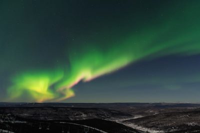 November 22, 2019 Aurora Borealis & Aurora Australis: Nature’s Mesmerising Light-Show
- September 5, 2018 Insects from Hell: Mecoptera, the Fly with a Scorpion Tail
 July 11, 2019 The Jewel of Manipur: The Loktak Lake is the Only Floating Lake in the World
- April 14, 2019 Fingal’s Cave: The Musical Geometry of Nature’s Domain
The post Hoosier Cavefish: The Blind Cavefish from Indiana Named after Their NCAA Basketball League appeared first on .
]]>The post The Lonar Lake: An Astronomical Marvel appeared first on .
]]>
Lonar lake, Maharashtra. (Praxsans / Wikimedia Commons)
Located in Maharashtra’s Buldhana district at Lonar, is a “saline, soda lake”- the Lonar Lake. It is said to have been created during the Pleistocene Epoch due to the impact of a meteor. It happens to be a hypervelocity impact crater, consisting of basaltic rock on Earth. There are three other known basaltic impact structures like the Lonar crater, which may be found in the south of Brazil.
An overview of the Lonar Sarovar Lake
The Lonar Crater is said to be fifty-two thousand years old. It was formed when a meteor weighing at least 2 million tonnes crashed into the earth at an approximate speed of 90,000 kmph. The crater is 1.8 km wide and 150 m deep. The water in the lake is saline, as well as alkaline and is surrounded by hills that have many fascinating temples. Despite the rarity of this lake, very few people have heard of Lonar Lake apart from the locals of the place and some trekkers.
The Lonar Lake contains various sodas and salts. In times of dry weather, evaporation decreases the level of the water and soda is collected in large quantities. There are two small streams, called “Purna” and “Penganga” that drain into the Lonar Lake. A well having fresh water is also located on the southern side, close to the edge of the water.

Satellite photo of Lonar Lake. (NASA)
Home to diverse flora and fauna
The slopes of hills around the Lonar Lake are covered with trees. The savannah-like area houses teak, bastard teak, the Indian screw tree, and the Pala indigo (also known as dyer’s oleander). The surrounding shrub-savannah contains plants like the Egyptian acacia and Ziziphus spp. Along the shore of the lake, the “non-native Prosopis juliflora” can be seen growing. The alluvial terrace in the northeast along the Dhara River is used for agricultural purposes. Some of the main crops that are cultivated are maize, millet, okra banana, and papaya.

Lonar Crater during monsoon. (V4vjk / Wikimedia Commons)
Lonar Lake has two unmistakeably distinct regions that do not mix. The outer neutral region (pH level of 7) and the inner alkaline region (pH level of 11) each have its own flora and fauna. The lake serves as a haven for a diverse range of plant and animal life. Several resident and migratory birds are found on the lake. This includes the black-winged stilts, brahminy ducks, golden oriole, blue jays, red-wattled lapwings, hoopoes, tailorbirds, magpies and swallows among others.
Several reptiles like the monitor lizard, snakes, and scorpions are also found on the lake. The Lonar Lake is also home to several thousands of peafowls, chinkara, gazelles, langur, mongoose, barking deer and many insects and amphibians.
Lonar Lake has non-symbiotic bacteria that help in nitrogen fixation. Studies have shown microbes like Slackia sp., Actinopolyspora sp., Paracoccus sp., Klebsiella sp., and Halomonas sp. live only in alkaline conditions that have a pH level of 11.
Breathtaking sites around Lonar Lake
There are several places around the Lonar Lake that are visited by tourists throughout the year. The Ajanta and Ellora Caves, for instance, are UNESCO World Heritage Sites. Daulatabad, Khuldabad (also known as the Valley of Saints), the very famous Grishneshwar Temple, and the Pitalkhora caves are other famous spots. However, not many people visit the Lake itself, because not many know about its existence. This beautiful lake is a four-hour drive from the city of Aurangabad. The road has picturesque villages and paddy fields that provide a refreshing change from the dull greyness of the city.
The trek to this marvellous lake is a bit tricky owing to the quicksand on the banks, and the path itself is rather slippery. On your way to the lake through the jungle, you may come across various types of minerals. You could stumble upon ruins of temples which are now home to insects and bats. The forest area near the Lonar Lake is a paradise for nature photographers and those who love birds and ardent bird-watchers.

A temple at the banks of Lonar lake. (Rohanguj2 / Wikimedia Commons)
As mentioned earlier, there are a number of temples surrounding the lake, many of which are in ruins now. There is the Shankar Ganesha Temple which has a notable rectangular idol of Shiva. The Ram Gaya Temple and the Kamalja Devi Temple is full of life during Navratri.
There is a myth about the Dhara or Sita Nahani Temple, which is said to be the place where Sita is said to have bathed. There is nothing remarkable about the architecture, but there is a kund inside the temple. Into this, a perennial freshwater spring flows, that feeds the lake below.
The most significant temple is said to be the Daitya Sudan Temple which is dedicated to Lord Vishnu and is located in the town. Lord Vishnu is said to have slain the demon Lonasura who also lent his name to the village. Locals believe that the crater had been the demon’s den and that the lake had murky water which was a result of the spilt blood of the demon. The temple structure itself is said to be a remnant of the Khajuraho style, with erotic sculptures of couples and ferocious ravaging beasts.
A haven in danger
Unfortunately, this astronomical marvel is facing several environmental as well as anthropological problems that threaten its very existence. The lake’s underground water source has been disturbed by illegal excavation activities that are carried out. Tourist activities also cause severe damage to the surrounding land. The perennial streams, “Dhara” and “Sita Nahani”, are one of the sources of water for the lake. However, these streams are also used for bathing, washing cattle and clothes, and for other domestic uses by the local people, pilgrims and the tourists. The household wastes containing detergents are disposed into this lake.
The agricultural fields surrounding the lake use toxic materials like pesticides and fertilizers that pollute the lake water. The ecosystem of the Lonar Lake is getting damaged because of sewage being dumped into the waterbody. Commercial activities around the lake have also harmed the natural topography of the lake. The increasing pollution has greatly distressed the flora and fauna of the Lonar Sarovar.
Enjoyed this article? Also, check out “The Jewel of Manipur: The Loktak Lake is the Only Floating Lake in the World“.
Fact Analysis:
STSTW Media strives to deliver accurate information through careful research. However, things can go wrong. If you find the above article inaccurate or biased, please let us know at [email protected].
RELATED
- July 11, 2019 The Jewel of Manipur: The Loktak Lake is the Only Floating Lake in the World
 April 9, 2018 Dallol, Ethiopia: Alien World on Earth
 June 14, 2019 Padmanabhaswamy Temple: The Richest Temple in the World with Gold Worth $22 Billion in Six Vaults
 September 21, 2019 Batu Caves of Malayasia – The Largest Shrine to Lord Murugan Outside India
The post The Lonar Lake: An Astronomical Marvel appeared first on .
]]>The post The Jewel of Manipur: The Loktak Lake is the Only Floating Lake in the World appeared first on .
]]>
Loktak Lake in Manipur, India. (Sharada Prasad CS / Flickr)
Situated near Moirang in the state of Manipur, India, Loktak Lake is the largest freshwater lake of North-eastern India. The unique phumdis, a heterogeneous mass of vegetation, soil and organic matter at various stages of decomposition found floating over it, characterises the waterbody. Loktak Lake’s claim to fame is its reputation as the only “floating lake” in the world.
An overview of the Loktak Lake
The Lake is located about an hour’s drive away from the capital city of Manipur, Imphal. The Loktak Lake houses more than 700 species of flora and fauna- aquatic as well as on the ground. Whether it is the diversity of migratory birds, or the unique indigenous animals, the natural wildlife of the region is truly astounding.
Loktak Lake was at first deemed as a Wetland of International Importance by the Ramsar Convention of March 23, 1990. The Montreux Record listed the site as a Ramsar site where changes in ecological character have occurred, are occurring or are likely to occur.
Keibul Lamjao National Park, the only floating national park in the world, is located near the Loktak Lake, which makes this belt even more interesting. The endangered brow-antlered deer of Manipur, known as the Sangai, also resides here. This majestic beast is the official animal of the state, and its hooves are perfect for walking on the native phumdis.
Home to diverse flora and fauna
Loktak Lake is a paradise for birds. Out of the 101 species of birds that are found in Loktak, three are globally threatened. Some of the rare birds found are the Common Pochard (vulnerable), Ferruginous Duck (near threatened), Japanese quail (near threatened), and Manipur Bush Quail (endangered). Also found, are the Northern Pintail, Gadwall, Greylag Goose, Red Collared Dove, Sarus Crane, Great White Pelican, Black Kite, Pied Kingfisher and the Oriental Skylark. Some of the gorgeous fauna inhabiting the region includes the Indian python, sambar, barking deer, rhesus monkey, hoolock gibbon, Indian civet, and Temminck’s golden cat.
An approximate of 1,500 tonnes of fish is sourced from the Lake per year. The State Fishery Department introduced several fingerlings of Indian and exotic major carps. The new varieties of fish introduced in the lake include silver carp and grass carp. Old varieties of local fishes like ngamu, ukabi, ngaril, pangba, tharak, and ngashap which were near decline have also been reintroduced into the system.
The lake has a rich biological diversity that includes more than 200 species of macrophytes that survive in water.
Boosting a growing economy
The Loktak Lake region is a source of exotic beauty that has allowed the local tourism industry to thrive. The role of the Lake goes much beyond this, however, and has an important role to play in other aspects of the economy of Manipur as well. It acts as a source of irrigation, drinking water supply, and also provides water for hydropower generation. The Loktak Lake also sustains the livelihood of the fishermen living in the area.

A fisherman out for a catch at the Loktak Lake. (Sudiptorana / Wikimedia Commons)

View of Loktak Lake and Phumdis. (Sharada Prasad CS / Flickr)
Breathtaking sites around the lake
One of the most exotic experiences in the region would be the early morning boat rides deep into the heart of Loktak Lake. Local long-tailed fishing boats are a popular mode of transport that is often let out for tourism purposes as well. Another interesting occurrence in the region is the peculiar mode of travel that often comes as a surprise to tourists- vehicles accommodating at least 4-5 on top of its roof.
The exquisite floating islands housed within the Loktak Lake are made of decomposed biomass. These islands have small huts with thatched roofing which the fishermen use as their homes on a regular basis. These islands embody the essence of the Loktak Lake region and the lifestyle of the inhabitants, thus making for a popular tourist attraction as well.
A haven in danger
The Loktak Lake, like most of nature’s havens, is now endangered due to pollution, decline in diversity of the fauna, and the thinning of phumdis. There has also been a loss of green cover in the area around the catchment. Deforestation and shifting cultivation has hastened the process of soil erosion, thus leading to the shrinkage of the Lake’s perimeter due to siltation.
The thickness of the phumdis has reduced significantly in the Keibul Lamjao National Park, which threatens the Sangai deer. This also affects the migration of fishes from the Chindwin-Irrawaddy River System of Myanmar. There has been a huge decrease in cultivated plantations, as well as major food plants, resulting in starvation of the endangered Sangai deer. Because of the thinning of the phumdis, the hooves of these deer get stuck in the marsh which often causes them to drown. The production of the edible fruit and rhizome of lotus plants has reduced by a huge margin. There has been a degradation of plants due to water pollution as well. The people whose livelihood depends on the selling of edible lotus plant products have greatly suffered from the sudden decline in their growth.
Despite the many threats that the Loktak Lake is currently facing, the locals still regard it as the crowning “jewel” of Manipur. The locals living in the area not only value the lake, but they also see it as a natural treasure. The lake has been home to them and provided them with their means of livelihood. The tourist attraction also adds to the growing economy of the state. However, much needs to be done in order to protect and preserve the Loktak Lake, as well as the sole floating national park across the world- the Keibul Lamjao National Park. If the pollution around the region is not kept in check, this treasure trove housing hundreds of unique flora and fauna will soon be extinct.
Enjoyed this article? Also, check out “The Lonar Lake: An Astronomical Marvel“.
Recommended Visit:
Keibul Lamjao National Park | Manipur, India
Fact Analysis:
STSTW Media strives to deliver accurate information through careful research. However, things can go wrong. If you find the above article inaccurate or biased, please let us know at [email protected].
RELATED
- July 17, 2019 The Lonar Lake: An Astronomical Marvel
 June 25, 2018 Tsingy de Bemaraha National Park: Natural Beauty of Stone Forest in Madagascar
 January 29, 2019 The Egyptian Vultures of Tamil Nadu’s Vedagiriswarar Temple
- October 11, 2019 Champawat Tiger: The Killer of 436 Humans is a Case of Animal-Need Pitted against Human-Greed
The post The Jewel of Manipur: The Loktak Lake is the Only Floating Lake in the World appeared first on .
]]>The post Rainbow Eucalyptus: A Stunning Demonstration of Nature’s Vibrant Art appeared first on .
]]>
Rainbow Eucalyptus in Garden of Eden Arboretum, Hawaii. (Thomas / Flickr)
The Rainbow Eucalyptus has several names to reflect its myriad hues, also known as the Mindanao gum or Rainbow gum. The scientific name of the plant is Eucalyptus Deglupta, coined by Carl Ludwig Blume. It is a tall, majestic tree with a kaleidoscopic trunk, and is native to the Philippines, Indonesia and Papua New Guinea.
Spectacular as it is, nature has myriad ways of exhibiting her beauty. Sometimes it is through a subtle flower, beautiful in its understatedness, at others, a more vibrant and obvious expression of colour. The Rainbow Eucalyptus is definitely in the latter category, mesmerizing onlookers with its brilliant colouring.
An enchanting tree
The tree earns the ‘rainbow’ nickname because of its periodic change in colours. It sheds the outer layer of its bark, each time revealing a new colour. In its native environment, the tree reaches a massive height of 250 feet. On U.S soil it reaches a mere 100-125 feet, which is still pretty large compared to standard trees. The Rainbow Eucalyptus is unique, considering it is the only variant of the eucalyptus tree found in the Northern Hemisphere. It does not grow in frost-prone climates, thus mostly thriving in Hawaii, southern parts of California, Texas and Florida.
The kaleidoscopic trunk of rainbow eucalyptus tree
Yellow, Green, Orange, Red, Brown, Purple, Maroon and Blue are a few of the colours visible on the tree trunk. While this may sound farfetched, it is an astounding feat of nature that actually exists. In fact, the colours on the trunk are so captivating and bright, they may even look fake or painted on. Sometimes, it also ends up giving a pastel effect. Each tree sheds its skin in a unique manner, ensuring no two trees have the same colouration in any given point in time. The Rainbow Eucalyptus is also referred to as a ‘living work of art’.

A rainbow eucalyptus tree. (Udi h Bauman / Flickr)
The singular features of the tree
As mentioned earlier, the tree reaches a height of 250 feet in its native habitat. Out of its native environment, its growth is stunted to a maximum height of 100-125 feet. The diameter of the trunk varies within 6 to 8 feet (or) 72 to 96 inches. The tree produces both flowers and leaves in abundance. While the flowers are white in colour, the leaves are sufficiently wide and evergreen. The leaves of the Rainbow Eucalyptus have glands which secrete aromatic oils. When these leaves are pressed, they release a relaxing and pleasant scent. However, the quantity of oil produced is less than other eucalyptus trees. This particular variant is thus not used for commercial purposes. The tree is used to produce paper from pulpwood in the Philippines.
The no-petal flowers

Flowers of rainbow eucalyptus. (Forest & Kim Starr)
Although the flowers of the Rainbow Eucalyptus do have stamens and pistils, they lack petals and sepals. The anatomy of the flower is complex and consists of two sets of reproductive organs: stamens being the male reproductive organ and pistils, the female.
Taking up the shape of a capsule, the flower bud has a conical lid called an operculum. With time, the operculum matures and becomes dark and wrinkled. As the bud opens, the stamen expands and pushes the operculum off the top of the capsule. There are several stamens which look like tassels, surrounding the pistil.
The capsule then becomes a woody fruit as soon as pollination and fertilization have been completed, and is referred to as a gumnut. Bees carry out the pollination required by the flowers of the Rainbow Eucalyptus.
Eucalyptus oil and its properties

Leaves of Eucalyptus deglupta. (Forest & Kim Starr)
Long, narrow and having a spear-like shape, the leaves of the plant have a leathery texture and hang from the branches of the tree. The oil produced by these leaves is volatile and aromatic in nature. When several trees grow near each other, they form a thin vapour, almost like a mist, in the surrounding air.
There are several uses of eucalyptus oil which provide a number of health benefits if used with utmost care and precision. The vapour opens airways in breathing problems and is often used in massage treatments for the relaxation of muscles. It is, however essentially toxic and dangerous if used in its raw form. The oil must always be sufficiently diluted with other liquids to make it useful. The key active ingredient is eucalyptol or cineol. A lot is yet to be discovered in the case of medicinal uses of eucalyptus oil.
Why is the Rainbow Eucalyptus a colourful marvel?
After extensive research, a botany professor at Florida International University by the name of David Lee has come to a conclusion about the plant’s colouration.
Each layer of the bark has thin cells that surround it. These are transparent in nature and allow us to observe the chlorophyll produced by these plants during photosynthesis. As time passes, the layer of cells is filled with pigments called tannins. Tannins are primarily brown, red or yellow in colour. However, various combinations of tannins result in the myriad colours that we see on The Rainbow Eucalyptus.
Disadvantages of growing the rainbow eucalyptus
While these trees are mesmerizing and majestic, they also have certain disadvantages to keep in mind when you grow it. They capture a lot of space due to their massive height, and during shedding season, it creates a substantial mess. Its roots may affect buildings and roads, and weaken the underlying foundation.
Another drawback is that the tree does not always grow the colours that are expected of it. The colours often depend on the place where it is grown and the weather in that particular area. Conditions such as temperature, humidity, airflow etc are also major factors that affect the colouration in these trees.
Unique facts about the rainbow eucalyptus
The tree can have a lifespan of 50 – 150 years, growing an average of 3 feet per year and is said to be deer resistant. Koalas mainly feed on eucalyptus leaves, which require a lot of energy to digest. This is why a koala sleeps up to twenty hours a day, with minimal energy expenditure. Interestingly, the shedding that produces the colours in a Rainbow Eucalyptus, is also an effective method for the tree to get rid of parasites.
Enjoyed this article? Also, check out “The Manchineel Tree: One of the Most Toxic and Dangerous Tree in the World“.
Fact Analysis:
STSTW Media strives to deliver accurate information through careful research. However, things can go wrong. If you find the above article inaccurate or biased, please let us know at [email protected].
RELATED
- May 16, 2020 Xylaria Polymorpha: A Macabre Mushroom that Resembles a Dead Man’s Fingers
- April 8, 2019 The Manchineel Tree: One of the Most Toxic and Dangerous Tree in the World
- August 30, 2018 Saving the Kakapo – The World’s Strangest Parrot
- September 11, 2018 Cave of the Crystals: A Geological Wonder with Giant Shimmering Crystals
The post Rainbow Eucalyptus: A Stunning Demonstration of Nature’s Vibrant Art appeared first on .
]]>The post Pamukkale: The Cotton Castle in a Mess of Limestone and Healing Waters appeared first on .
]]>
Pamukkale or Cotton Castle. (Antoine Taveneaux / Wikimedia Commons)
She made history with her beauty and brain. And patronizing a place which would become a popular tourist jaunt. Welcome to Cleopatra’s Antique Pool, where the Egyptian Queen, Cleopatra (69-30 BCE), known for her penchant for health and beauty, spent quality time in the hot springs. The pool is one of the 17 water bodies located at Pamukkale (meaning cotton castle) in the Denizli province of the Republic of Turkey. It is a scenic spread of dazzling white calcium carbonate in 8860 ft. X 1,970 ft X 525 ft. Verily called ‘spa town’, Pamukkale is a health cum healing joint in the valley of river Menderes. It is a medley of slabs, pillars and caves made of calcium compounds. The name cotton castle comes from a legend that bales of cotton were spread out to dry in open. But, in time, these mutated to the present day limestones. A tad realistic as the cotton is the principal agriculture crop of the area.

Pamukkale, Turkey. (Katie Hunt / Flickr)
Created by the natural forces of hot water springs and earthquakes
The formation of the cotton castle is a handiwork of 2 elements, water and earth. Hot water springs flow out from bowels of the earth. Their waters are supersaturated with minerals, which precipitate as water spreads on the uneven ground to find its base. The precipitate settles into terrace formations. Carbon-di-oxide (gas) disengages from the mixture and escapes into the open air. Some of the gas is trapped in the mass of precipitate that falls on the wayside, on cliffs and slopes, creating calcium bubbles. From distance, the bubbles look like fluffs of cotton on limestone slabs (travertines) and pillars (stalactites). Amid these white and shining terraces, some caves are also formed in a natural way. The air in the caves is flushed with carbon dioxide and these were used for religious purpose in ancient times.
Pamukkale: A historical site, health resort, and religious hub
The site, back in 190 BC, was a holy city called Hierapolis. It was a place known for sacred rites and spiritual pursuits, as well as for curing of diseases with mineral rich hot water springs. Frequented by the royalty, including the Egyptian Queen Cleopatra, it was famed as the retirement retreat for the Roman Kings. Two massive earthquakes, one in 60 AD and another in 1334 AD ravaged this historic city. Nevertheless, the ruins of the city add to the overall charisma of Pamukkale as a picnic spot. The ruins are a key component of ‘Cotton Castle’ which was declared the world heritage site by UNESCO in 1988. Rubbles of buildings, the sediment of calcium terraces from hot mineral water, collection of spring water in pools of varying depths and size; all added to make natural upheavals into a piece of fine art. Among the relics dotting the cotton castle, Hierapolis theatre with its VIP boxes, 2 tier seating and niche compartments, a devious church, graveyard, city walls and pathways are noteworthy.
Hotels and approach roads planned to protect the site’s natural formation
With the reputation Pamukkale, as an excursion cum historical site spreading far and wide, in the year 1960, hotels and approach roads were built within and outside of it. The construction within was found detrimental to the Travertines and water pools. Hence it was demolished. Further, laws were enacted to ensure that water from pools is not misused by the hotels, but made available of tourist for bathing and excursion.
Surprises galore for the visitors
Karahayit hot spring, another attraction at Pamukkale, is a maze of coloured water. The colour reflected in water is decided by the nature of dissolved oxide in it. Located 5 km away from Pamukkale, the water of these springs may be up to 55° Celsius hot.
A visit to Pamukkale is an out-of-this-world-experience. Trekking barefoot on shining terraces, sitting on the poolside, bathing or simply splashing in mineral water, with temperature ranging upward of 35° Celsius, is a magical feeling. Bathing is generally safe. Water is drowning deep only in some places, and provisions are made to attend to emergencies. The ground can be slippery and limestone can have sharp edges; so caution is advised.
Paraglide for a bird’s eye view
Want to watch the whole thing from the sky? You can, thanks to the paragliding facilities available. A walk through the Pamukkale Nature Park can be your sneak peek into local customs, as the place is popular for its wedding ceremonies. For boating in the lake, and being one with hordes of ducks out there, you can hire a paddle boat and have your heart’s fill.
Enjoyed this article? Also, check out “Clear Water Lagoons and Pristine White Sand Dunes of Lençóis Maranhenses National Park“.
Fact Analysis:
STSTW Media strives to deliver accurate information through careful research. However, things can go wrong. If you find the above article inaccurate or biased, please let us know at [email protected].
RELATED
- August 17, 2019 Euphrates River: A Dying River that Birthed One of the Oldest Civilisations
- October 16, 2018 Clear Water Lagoons and Pristine White Sand Dunes of Lençóis Maranhenses National Park
- February 10, 2019 Ladakh Beckons You for a Riveting Tour of Nubra Valley
- June 19, 2020 Tree of 40 Fruits: A Patchwork Canopy of Myriad Fruits
The post Pamukkale: The Cotton Castle in a Mess of Limestone and Healing Waters appeared first on .
]]>The post Sarcastic Fringehead: Most Quarrelsome Fish That Has a Big Mouth appeared first on .
]]>
Sarcastic fringehead (Neoclinus blanchardi) with its mouth open. (Wikistudent348 / Wikimedia Commons)
One of the most quarrelsome fish ever found off the coast of California and Baja California, US, is the foot-long Sarcastic Fringehead. Its scientific term is Neoclinus blanchardi. The fish also falls under the classification of Teleostei: Blenniiformes.
Found mostly in temperate latitudes of the northeast Pacific Ocean, sarcastic fringehead is a small but fascinating fish that belongs to the ‘Family Chaenopsidae’ or simply tube blennies. A blenny is a small tube-like long-bodied scale-less fish found mostly in coral reefs or rocky coastal regions.
Dr Blanchard discovered the species

Sarcastic fringehead. (James Martin / Wikimedia Commons)
According to researchers like Dr SB Blanchard, sarcastic fringehead can mostly be found on an exposed coast, on hard mud bottom or sand below low tide. As per Dr Blanchard’s findings, the sarcastic fringehead is the largest of all fringehead fish.
Such an aggressive fish is partly named after researcher Dr Blanchard, who is said to have discovered the species close to San Diego.
Residing at depth of three to 61 metres, the saltwater fish possess some typical family characteristics. It has a long fin on the back and fringe-like cirri (slender tentacle) on its head. The fin on the back extends from the head to the tail fin.
The dorsal spines of the sarcastic fringehead possess two ocelli or eye-shaped spots. The first can be spotted between the first and second spines. The second can be seen between the 5th and 9th spines. The ocelli are blue with yellow rings.
Displays incredible combative behaviour
The male sarcastic fringehead displays incredible combative behaviour while defending its territory. It mostly lives in tube-like structures created by other sea animals or a burrow. However, it loves to take shelter in an empty snail or seashell. At times, it has been found to live inside a soda bottle.

Sarcastic fringehead emerging from a shell. (Guilhem Vellut / Flickr)
Interestingly, a female sarcastic fringehead lays its eggs in a male’s shelter. They spawn between January and August. In turn, the male protects the eggs from possible predators until they hatch. This kind of sexual selection intensifies male territoriality and the resultant competition.
The eggs that are laid are generally measured 0.9 to 1.5 mm in diameter. Each and every egg contains an oil globule component along with some filaments. These help the eggs to get attached with a nest and also other eggs.
Aggressive turf wars
During such aggressive turf wars, a male sarcastic fringehead opens its rather extremely large mouth to scare off the predators or its territorial rivals.
The bloom of the male sarcastic fringehead’s mouth is intimidating. The size of its mouth is at least four times the size of the mouth when shut. This size of the mouth permits a male to establish its dominance over its smaller rivals.
During aggressive combat conditions, a male sarcastic fringehead thrusts its large mouth at its rival’s mouth. At times the mouths of the two rivals touch one another, in what is known as mouth wrestling. Such a strange and aggressive behaviour can also be termed as ‘gaping display’.
Check out the video: https://youtu.be/BjexNXJYblQ
Typically though, the fish with the smaller mouth surrenders. It escapes from the territory in dispute. This way, the rivals actually do not fight.
Sarcastic fringehead uses colour to communicate
According to marine biologist Watcharapong Hongjamrassilp‘s thesis, the male sarcastic fringehead uses the colourfulness of its mouth to communicate with its rival.
It shows that this extremely temperamental sarcastic fringehead, which is a fiercely territorial creature, aggressively protects its home from intruders of any seizes including humans. In times of danger, apart from displaying its enormous mouth, the sarcastic fringehead snaps its needle-like teeth and jaws for defence.
If and when an intruder advances forward to take up the challenge, only then does it use effectively its teeth. Strangely, for such a quarrelsome creature, the fish has poor eyesight. It cannot see its foe until it dances cheek-in-cheek with the rival.
Feeds on a mass of tiny floating organisms
During some moments of peace, the sarcastic fringehead rests inside its home.
Scientists believe that the sarcastic fringehead feeds on a mass of tiny floating organisms. During the season of squid spawning, this fish devours huge quantities of squid eggs. However, the oversized mouth of the male fish hampers its ability to feed properly.
Interestingly, this species of fish do not have the ability to eat food through a suction process. As per studies, these omnivores fish consume at least 13.6 times its body weight on an annual basis.
Biologists have observed that the brownish-grey coloured sarcastic fringehead lives on for up to six years.
Enjoyed this article? Also, check out “An Up-Close and Personal Encounter with the Alien-Like Pacific Barreleye Fish“.
Fact Analysis:
STSTW Media strives to deliver accurate information through careful research. However, things can go wrong. If you find the above article inaccurate or biased, please let us know at [email protected].
RELATED
- December 4, 2019 Great Blue Hole: Largest Underwater Sea Hole off the coast of Belize is a Diver’s Paradise
 May 26, 2019 Neptune Memorial Reef: An Eco-Friendly Underwater Graveyard Off the Florida Coast
- November 4, 2019 Goblin Shark: The Alien Shark of the Deep Sea, with a Slingshot Mouth
- November 11, 2019 Bristlecone Pine: The Oldest Trees of Our Planet
The post Sarcastic Fringehead: Most Quarrelsome Fish That Has a Big Mouth appeared first on .
]]>The post Sea Cucumber: The Modest Marine that Needs to be Protected appeared first on .
]]>
Thelenota ananas, a steadily decreasing endangered species of sea cucumber. (Aexander Vasenin / Wikimedia Commons)
In nature, there are no superior or inferior life forms. All living creatures are equally important for the environment. A creature that’s meek, easy to hunt, and high on man’s greed list, can go extinct, endangering the host ecosystem. This seems to be happening to some species of sea cucumber. In the Malayan language of Malaysia, Brunei, Singapore, Indonesia and southern Thailand, this marine fish is also known as Trepang.
It’s a cousin of starfish and sea urchins
Sea cucumber is found in the Indo-pacific region of the ocean. That includes parts of Africa, Japan, China, Australia and Mariana Islands. Generally, sea cucumber lives in shallow lagoons, reefs and rubbles, searching food in the sand at the bottom of the ocean. It belongs to a group of marine animals called Echinoderm, and its body size varies from 0.75 inches to 6.5 feet. Starfish and sea urchins are other members of this group.
Typical echinoderms have a radial body symmetry. But the body symmetry of sea cucumber is bilateral, i.e., it has a well defined dorsal and ventral side. Grossly, the body is cucumber-shaped, muscular and flexible. When threatened, it shoots out sticky threads from its body to entangle the enemy. It can mutilate its body and shoot internal organs out through the anus in self-defence. Organs thus wasted in self-defence can regrow, and the organism is once again its normal self.
Conservation efforts ignored in favour of big fishes
The tenacity of this marine animal, however, has failed in the face of human greed. The popularity of sea cucumber, as food and drug in the Asian continent, has led to its indiscriminate fishing. Consequently, many species are on the verge of extinction. But alarm bells don’t seem to be ringing. Maybe conservation is focussed more on sharks, whales and other trendy fish. Some varieties of sea cucumber, in the meanwhile, are exposed to a real threat of extinction.

Elephant Trunkfish (Holothuria fuscopunctata) a least endangered species of sea cucumber. (François Michonneau / Wikimedia Commons)
Keen market demand spelled doom for the sea cucumber
Some species of sea cucumber sells from US$ 10 to US$ 600 per Kg in Hong Kong and China. The cold water variety of it sells for US$ 3,000 per Kg dry matter. Demand for the fish rose with the rising prosperity in China. Consequently, hunt for the sea cucumber intensified in more than 70 countries. Wild Trepang was extensively fished from the seashores of poor countries.
Currently, the International Union for Conservation of Nature (IUCN) deems 7 species of sea cucumbers (from a total of 371 species) as endangered and 9 species are vulnerable. High market demand for sea cucumbers has consistently depleted the population of these hapless creatures. Fishermen were paid well, and in advance, hence they went all out fishing and damaging the marine ecosystem. After tapping the natural habitat of required variety, other virgin waters were searched and exploited to the hilt. Thus, the market demand was met. Marine resource of the economically poor nations was exploited to the detriment of sea cucumber. Hence, the rich countries were advised to help poor nations through means other than poaching on the latter’s wealth of Trepang fish.
Sea cucumbers must survive for the health of marine life
The conservation of the sea cucumber is vital for the health of the marine ecosystem. It scavenges on the sand of the sea floor. Dead organic matter mixed in the sand is used up as food and the ingested sand is expelled through the anus as excreta. The excreta act as food for other sea organisms. The alkalinity of the Trepang excreta reduces pollution-induced acidity of seawater and thereby helps in keeping the marine ecosystem in good shape.
Sea cucumber as food
The existential crisis for some species of sea cucumber hasn’t come a day too soon. The countdown began as early as the 17th Century when Trepang fishing became big business in the islands of South East Asia. Sea cucumber was hugely popular in China as food and as an aphrodisiac. Huge market demand from China made the Makkasar town (Indonesia) a nodal centre for trading in the sea cucumbers.
Catching the sea cucumber is easy; no special skill or gadget is required. A feel with bare feet can locate the muscular creature in shallow waters. It is then taken out either by clutching with bare hands or by aimed stabbing in water. Trepangs were easily impaled using a multi-pronged spear. Weights were attached to spear to make it heavy and fall steadily down in the water and stab sea cucumbers.

Sea cucumber gourmet. (Max Pixel)
The rising demand of sea cucumber in 1980s and 1990s led to the fishing of its deep sea varieties. This is done with the help of compressor diving. A recent report of FAO reveals that major sea cucumber reservoirs worldwide are depleting at an alarming rate. Not surprising, considering that worldwide demand for it, as food and medicine, recorded a sharp increase in the 20th century.
Hopefully, the 21st century should see some positive developments towards conservation of sea cucumbers. Fishing them prudently would obviously be the first and foremost step in this direction. That alone will ensure an adequate supply of sea cucumber for human food, as well as a healthy environment for plants and animals living in seawater.
Enjoyed this article? Also, check out “Proboscis Monkey: The Rare Borneo Monkey Species with an Unusually Long Nose to Lure Its Females“.
Fact Analysis:
STSTW Media strives to deliver accurate information through careful research. However, things can go wrong. If you find the above article inaccurate or biased, please let us know at [email protected].
RELATED
- March 16, 2019 An Up-Close and Personal Encounter with the Alien-Like Pacific Barreleye Fish
- January 8, 2019 Proboscis Monkey: The Rare Borneo Monkey Species with an Unusually Long Nose to Lure Its Females
 November 5, 2018 2004 Indian Ocean Earthquake & Tsunami: Remembering the 230,000 People Killed in Its Wake
- November 4, 2019 Goblin Shark: The Alien Shark of the Deep Sea, with a Slingshot Mouth
The post Sea Cucumber: The Modest Marine that Needs to be Protected appeared first on .
]]>The post Himalayan Monal: The Nine-Coloured Bird of the Himalayas appeared first on .
]]>
A male Himalayan Monal. (Ajit Hota / Wikimedia Commons)
The Himalayan Monal, also known as the Impeyan Pheasant or Impeyan Monal, is a variety of pheasant found in the hilly forests of the Himalayan region. The scientific name of the bird is Lophophorus impejanus and it belongs to the Phasianidae family of the Galliformes order.
Ecological state
These birds are endemic to a vast belt including, Bhutan, China, Nepal, Pakistan, India (states of Jammu and Kashmir, Himachal Pradesh, Uttaranchal, Sikkim and Arunachal Pradesh), and even Myanmar. The bird is almost extinct in Afghanistan, and their numbers are steadily reducing in other areas due to various anthropological factors. As a result, they have been included in the IUCN Red List of Threatened Species (2016), albeit as a species of ‘Least Concern’ (LC).
Habitat of Himalayan monal
These pheasants are typically found residing in the oak-conifer forests of cool upper temperate regions, such as the Himalayan hills. Their preferred habitat also features rolling grassy slopes and cliffs, and an extensive understory of bamboo and rhododendron. The Himalayan Monal is a high-altitude bird that practices altitudinal migration as the weather changes. In the winter months they come down to 6,500ft. In the summers they move up to 16,000ft, wandering the grassy slopes above the tree-line. In general they maintain an altitude between 2,000 and 4,500m above the sea level.

Himalayan Monal (Lophophorus impejanus). (Koshy Koshy / Flickr)
Behaviour of the Himalayan monal
The Himalayan Monal spends most of its day foraging for insects, berries, shoots, and seeds. These pheasants have heavy bills which they expertly use for digging out subterranean insects and tubers from the slopes as well. Their tolerance to the snow is an added bonus to their lifestyle. The shrill curlew-like whistle of the Himalayan Monal is quite distinctive. These pheasants usually roam single or in pairs, especially during their breeding season between April and August. At other times they might also be spotted in small groups, or large conveys, while practicing communal roosting.
Description
The Himalayan Monal is one of the most stunning pheasants due to its distinctive iridescent metallic-coloured plumage. An average bird would measure to around 70 cm in length and between 4.4-5.2 lbs in weight, and it is considered to be a somewhat large bird. The average female of the species is a tad smaller and lighter than its male counterpart.
Male Himalayan monal pheasant
The Himalayan Monal is also known as the ‘nine-coloured bird’ owing to the iridescent metallic-coloured plumage on the neck and wings of the adult male bird. With a white back and black underparts, the bird exposes a prominent white patch on its rump when in flight. The tail feathers of the male bird are consistently metallic reddish-brown coloured, ending at a darker shade towards the tips. A distinct blue patch around the eyes characterises the species.
Female Himalayan monal pheasant
Though still quite striking in appearance, the females of the species are less brightly plumed. They have a short crest and a white throat. The feathers on the upper parts of the hens are a dappled brownish-black. The tail feathers have are mix of white feathers and a layer with a black and copper splotched appearance. The females also have the characteristic blue patch around the eyes, as do the males.

An adult female Himalayan Monal. (Koshy Koshy / Flickr)
Immatures
The younger birds, including first year males, resemble the females of the species and are not very prominently coloured. The only way to distinguish an immature male from a hen is its black feathers in the breast and neck. The young males also have a slightly larger build.
Housing
Though a large bird, the Himalayan Monal is quite docile and easily trusting, specifically the females of the species. Owing to this, and their remarkable appearance, these birds are quite common in aviculture. As high altitude birds, these pheasants can survive the harshest of cold weathers. However, they must be adequately protected from warm summer conditions since they cannot tolerate high temperatures. Usually these birds are kept in pairs or trios, in well-drained and large aviaries, ideally of a minimum 112 sq. ft. dimension. A well-drained sandy soil is required due to these birds’ propensity for digging through the grass and other greenery.
Breeding
These pheasants attain sexual maturity around the age of 12 to 24 months, and generally start breeding the second year onward. Their breeding season starts around late-April. The male Himalayan Monals fan their tail feathers, bob the crest, and indulge in various bodily displays to attract the hens. Another notable signal is the males calling out throughout the day instead of just in the early mornings. The male birds get territorial and aggressive during breeding season, despite generally being of a genial nature.

Eggs of Himalayan Monal. (Muséum de Toulouse / Wikipedia Commons)
The birds create simple nests under bushes, or on steep cliffs, and are very attentive as parents. The Himalayan Monal generally lays two to five eggs, white or dirty white in colour with brown splotches. The hens must incubate them for an average of 28 days. The male bird usually guards the nest throughout to protect the eggs and fledglings from vicious predatory birds. The young chicks are completely independent by the time they are six months old.
These birds breed in captivity, as well as in they do in nature. Often the breeders separate the fledglings for rearing by hand, and they must be provided with ample space. Heavily susceptible to disease, the chicks should be kept in well-drained aviaries or wire-bottomed cages to minimize exposure to pathogens.
Trivia
Interestingly, the Himalayan Monal is also known as the Impeyan Pheasant, a name derived from that of Lady Impey- the first to keep these exquisite birds in captivity. The Himalayan Monal is the national bird of Nepal, and the state bird of Uttaranchal and Himachal Pradesh in India. The bird has been an intricate part of the local folklore of these regions. Its feathers even formed a part of their traditional headgear (before the criminalization of poaching). Thus we can see its immense cultural significance in these parts and its need for conservation.
Enjoyed this article? Also, check out “Hoatzin Reptile Bird: A Dinosaur-Like Bird with the Digestive System of a Cow“.
Fact Analysis:
STSTW Media strives to deliver accurate information through careful research. However, things can go wrong. If you find the above article inaccurate or biased, please let us know at [email protected].
RELATED
- October 11, 2019 Champawat Tiger: The Killer of 436 Humans is a Case of Animal-Need Pitted against Human-Greed
 March 27, 2020 The Insidious Practice of Bear Bile Farming
- February 10, 2019 Ladakh Beckons You for a Riveting Tour of Nubra Valley
 February 27, 2019 IAF Mirage 2000: The French-Made Fighter Aircraft that Answers India’s Call of Duty
The post Himalayan Monal: The Nine-Coloured Bird of the Himalayas appeared first on .
]]>The post Devils Tower in Wyoming: A National Monument and a Geological Wonder appeared first on .
]]>
Devils Tower National Monument. (Christen Gobel / Wikimedia Commons)
A film script is a baseline on which location for the shoot is decided. Steven Spielberg did the same. But the location found was so enticing that he discarded the script. And location became a new baseline, for an altogether new story. The result was the blockbuster Hollywood release of 1977, Close Encounters of the Third Kind. The location was a foothill called Devils Tower. But there is more to this giant stub, than what meets the eye on the silver screen. It is a mix of the physical and the metaphysical in Wyoming, America, near river Belle Fourche.
Devils Tower in Wyoming: A national monument
The Devils Tower is 867 feet high. Its top surface measures an acre and a half, and base circumference – about a mile. Declared a National Monument of America in 1906, the tower was held sacrosanct by the Indian tribes of America’s Northern Plains. Several word-of-mouth histories and references testify to its spiritual significance. In Arapahoe, the tower is called ‘Bear’s tipi’. Kiowa, another county, calls it ‘aloft on a rock’ and ‘tree rock’. The Native American tribes have used several expressions like: Bear Lodge, Bear Lodge Butte, Grizzly ear’s Lodge, Mythic-owl mountain, Grey Horn Butte, and Ghost Mountain. As wild bears inhabited the area in the past, the animals’ name became part of the tower’s identity.
The naming exercise was riddled with misinformation
How come Tower got named differently than mentioned in history and legends? The story begins with a geologist, Colonel Richard Irving Dodge, going on a scientific expedition to the Black Hills Region of Wyoming in 1875. He inquired about the tower’s name in the local language and understood the answer as ‘Wakansica’. That, translated into the English language, read ‘The Bad God’s Tower’. It was simplified to ‘Devil’s Tower’.
Now, the question arises about the missing apostrophe in ‘Devil’s Tower’. And why an ungrammatical usage ‘Devils Tower’ remains current? President Theodore Roosevelt had approved the same name as coined by Colonel Dodge, i.e. with-apostrophe Devil’s Tower. But a clerical mistake in the office of the president bypassed apostrophe and posted name as Devils Tower. The mistake was never corrected, so it remained as such. In the meanwhile, another mistake came to light. Colonel Dodge had inadvertently picked up a wrong word for translation. Right word was a similar sounding, but different, Wahanksica, which translates to English as ‘black bear’. This is also corroborated from multiple sources as explained in the foregoing.
Locals, who hold tower sacrosanct, demanded the renaming of ‘Devils Tower’ as ‘Bear Lodge’. Demand was rejected on the ground that a change would confuse people, and harm tourism.
Devils Tower formation
How the tower was formed is equally fascinating. From the earth’s hot inner core, molten rock (magma) keeps moving upwards. It may, or may not, reach to the surface of the earth. One such move happened 50 million years ago, but remained short reaching surface, thanks to a sedimentary rock coming in its way. In course of time, the sedimentary rock withered away, revealing the track followed by the intrusive lava. The magma or lava had cooled down into pillars of hexagonal shape, giving the protruding igneous rock an awesome formation. Grossly, the pillars appear to be hollow, but in reality, these are solid. The rock, light grey to beige coloured, is totally devoid of quartz (a plentiful mineral of the earth – crust).

Devils Tower. (Wikimedia Commons)
A crucible of nature’s bounties, adventure, outing and human faith
Vegetation on Devils Tower is a mix of lichens, moss and grasses. Chipmunks (squirrels) and more than 160 species of birds inhabit the top part of it. The Pine forest and the grasslands in surrounding areas are home to 40 species of mammals. That apart, the region has a vibrant population of amphibians, fishes and reptiles.
The tower is a popular destination for rock climbing. Prominent columns on the shaft are ideal for clutching, tethering and climbing the rock, and have a rocking experience. Five to six thousand rock climbers come here every year, especially in the month of June. That, incidentally, is also the time when people visit the tower for religious rites. In spite of being a tourist hub, Devils Tower retains its past image of a spiritual domain. Rituals of faith are a routine on the tower’s sacred sites, and tourists are advised not to touch objects related to such rituals.
Enjoyed this article? Also, check out “Devils Hole: The Only Wild Habitat in the World Where the Endangered Devils Hole Pupfish Are Found“.
Fact Analysis:
STSTW Media strives to deliver accurate information through careful research. However, things can go wrong. If you find the above article inaccurate or biased, please let us know at [email protected].
RELATED
 August 31, 2020 Ennedi Plateau and Aloba Arch: Home to Exquisite Natural Formations and ‘Extinct’ Animals
- April 14, 2019 Fingal’s Cave: The Musical Geometry of Nature’s Domain
 March 23, 2019 The Moeraki Boulders of New Zealand: Naturally Formed Spherical Boulders from the Paleocene Era
- March 2, 2019 Wave Rock: Where a Massive Prehistoric Wave, Just About to Break, is Etched Permanently in Stone
The post Devils Tower in Wyoming: A National Monument and a Geological Wonder appeared first on .
]]>The post Forest Fire: Birds Deliberately Setting Forests on Fire to Flush Out Prey appeared first on .
]]>
Bushfire in Australia. (80 trading 24 / Wikimedia Commons)
For the first time through the 1963 film called ‘The Birds’, director Alfred Hitchcock informed the world that avian attacks are nothing new and they could turn gruesome at times.
In the classic film, Hitchcock shows how birds can turn violent when nature becomes harsh and food supply depletes. The film was loosely based on a story of British author Daphne du Maurier.
Decades after the release of The Bird, Australian ornithologists are now confirming that certain birds have become creative in finding their food. The Australian birds have been using burning twigs to trigger bushfires during summer and scare prey into their waiting claws (talons).
Australian raptors

Brown falcon (Falco berigora). (Marc Dalmulder / Flickr)
According to ornithologist Bob Gosford of the Central Land Council in Alice Springs, Australia, the birds in question are Black kites, whistling kites and brown falcons.
Writing in an article titled “Australian Raptors start fires to flush out prey”, Bob Gosford says these predatory birds regularly gather close to the edges of bushfires. They then take advantage of the exodus of insects, small lizards and small birds.
He further writes that the avian creatures have not only learnt to use fire to trigger bushfires, but also learnt to control the fires. Therefore, bushfires are nothing but happy hunting grounds for Australian raptors.
Australian aboriginal lore
According to Australian aboriginal lore, the avian arsonists’ fire-bombing the savanna landscape is nothing new. They have been carrying fire to catch their prey across the savannas of Australia’s far north for centuries.
This is more or less the first recorded occurrence of fire being used by avian creatures.
Australian ornithologists confirm that birds make solo and at times group attempts to carry burning twigs in their claws to trigger wild bushfires. This behaviour is known to aborigines of the Northern Territory, an article in the Journal of Ethnobiology says.
However, European ornithologists refuse to accept the observations of the Australian aboriginals that bushfires are happy hunting grounds for the Raptors. That is why there has been no scientific documentation of this avian behaviour to date.
Fascinating phenomenon
In this context, Gosford and his co-authors spent at least six years to collect over 20 witness accounts across the Top End. This indicates that the behaviour of the Australian raptors appears to be spread across the tropics of Queensland and Western Australia.
Terming the Australian Raptor’s behaviour as a fascinating phenomenon, scientist Alex Kacelnik said this is the first time that he heard of birds trying to control fire. Kacelnik is an expert on animal tool use at the University of Oxford, United Kingdom.
Innovative solutions
The Australian Raptor’s behaviour, Kacelnik says, is an indication of how birds are good at finding innovative solutions to food problems. Kacelnik then speculates that the skill could be interpolated at far off locations and also among younger raptors in the same flock.
Till today, history has told us that humans and lightning have been the only vectors of fire Down Under. But, the behaviour of these “firehawks” is forcing us to re-examine human understanding of the history of fire in the Australian landscape.
Gosford’s co-author Dr Mark Bonta confirmed that most of the data they collected is based on their collaboration with Australia’s Aboriginal peoples. The natives, he feels, perhaps knew of the behaviour of the firehawks for 40,000 years. Bonta is a National Geographic grantee and geographer at Penn State University, US.
Killing frenzy
For decades, people in the Northern Territory of Australia have considered firehawks a part of nature.
Gosford writes that the firehawks like black kites and brown falcons perch on the edge of the wildfires and indulge in a killing and feeding frenzy.
In 1964, Australian journalist Douglas Lockwood compiled an autobiography of Waipuldanya Phillip Roberts in “I, the Aboriginal”.
In the autobiography, Roberts says he saw a firehawk pick up a smouldering twig in its claws and drop it in a fresh patch of dry grass. The firehawk then waited with its friends for the mad exodus of frightened reptiles, lizards and rodents.
Pack hunt
Roberts then said the process was repeated elsewhere after the area got burnt out.
Do the flying firehawks know what they are doing? Or, are they accidentally carrying the burning twigs? Researchers believe that the avian arsonists do know what they are doing. Their behaviour is not a fluke one, but a premeditated and coordinated pack hunt for scared prey, says Gosford.
He says the purpose or intent of these firehawks is simply to say that hundreds of them can get a good meal. This hypothesis confirms that a third force in nature has the ability to spread devastating bushfires. According to Dr Bonta, not all birds indulge in aerial arson. Firehawks like Black kites, whistling kites and brown falcons have mastered the art of triggering bushfires.
According to official data, every year, up to 75% of Earth’s tropical savannas burn and account for half of the biomass that burns worldwide. Australia is not an exception to this rule.
Between 1997 and 2011, at least 18% of Australia’s 730,000 square miles of savanna got burnt down each year.
Benefits of forest fire
Forest fires are a necessary and natural part of the ecosystem. Forest fires turn the ash from the dead trees and decaying plant matter in healthy forests as nutrients. These nutrients then return to the soil and enrich it in the process.
Another benefit is that the fire clears the thick overgrowth and allows sunlight to fall on the soil. This process helps native plant species to re-grow.
The forest fires also free the plants of invasive weeds and stop the spread of insects and diseases.
Interestingly, healthy and resilient trees survive the forest fire and spring back to life resulting in young and small forests. Such forests become home to diverse species re-establishing the changing ecology and life goes on.
Enjoyed this article? Also, check out “The Crooked Forest of Poland“.
Fact Analysis:
STSTW Media strives to deliver accurate information through careful research. However, things can go wrong. If you find the above article inaccurate or biased, please let us know at [email protected].
RELATED
 January 5, 2020 Australian Bushfires: Deadly Yet an Inextricable Part of the Australian Ecosystem
- March 2, 2019 Wave Rock: Where a Massive Prehistoric Wave, Just About to Break, is Etched Permanently in Stone
- January 15, 2019 Pink Lakes: Where Rose-Tinted Lakes Surrounded By Lush Greenery Are Truly a Sight to Behold
- May 10, 2019 The Great Emu War: When Thousands of Emus Evaded Australian Armed Forces and Won the War
The post Forest Fire: Birds Deliberately Setting Forests on Fire to Flush Out Prey appeared first on .
]]>The post Fingal’s Cave: The Musical Geometry of Nature’s Domain appeared first on .
]]>
Fingal’s Cave, Staffa Island. (Luk~commonswiki / Wikimedia Commons)
The major part of the European continent in 3rd century BC was ruled by a group of tribes called Celts. Their Folklores refer to a wonder cave called Uamh-Binn (the cave of Melody), which, at present, is known as Fingal’s cave. Located in the island of Staffa, Hebrides, Scotland, the cave has an ensemble of multifaceted rock pillars.
The cave, as per the legend, was connected to another area of a similar disposition. The area, a spread of 40,000 multifaceted rock pillars propping from the sea surface, is Giant’s Causeway (GiC) in Northern Ireland. Both sites, as of now, are rocking tourist destinations, famed for the unique geometric shape of their constituent rocks.

Giant’s Causeway, Northern Ireland. (Gerd Eichmann / Wikimedia Commons)
Fingal is a short form for the name ‘Fionn mac Cumhail’
The cave’s name ‘Fingal’ is borrowed from the name of a hero in a popular poem series penned by the 18th-century Scottish poet, James Macpherson. The series is a translation of Irish mythology originally scripted in Gaelic (a language of Celtic tribe of Scotland). Fionn mac Cumhail is the hero of the poem. Finn would have been a convenient short form for the hero’s name. But Finn, in popular usage, refers to a citizen of Finland, and this wasn’t acceptable to the poet. So, he tweaked Finn to ‘Fingal’ lest the cultural glory of Scotland and Ireland is shared by another country i.e. Finland.

Inside Fingal’s cave. (Luk~commonswiki / Wikimedia Commons)
His hugely popular work ‘Fingal’s cave, an ancient epic poem in six books’ was an inspiration for Sir Joseph Banks, a naturalist, who arrived at the cave in 1772 and was greatly impressed by it. As Fingal was the name of the hero in his favourite poem series, he gave the same name to the cave, calling it ‘Fingal’s Cave’.
Formation of Fingal’s cave
Formation of the cave, and the GiC began some 60 million years ago when a volcano burst tore through the overlying limestone rock. The molten lava cooled down to form hexagonal (six-sided) pillars of igneous rock. The pillars are so well structured as if made by man, not nature. The 20 meters high and 75 meters long Fingal’s cave, and GiC, both are made of mafic rock (dark coloured silicate, rich in magnesium and iron). Both are out and out a marvel of nature, having no human hand whatsoever in their formation.
On gross observation, all pillars seem alike. Closer observation though reveals subtle differences. Not all pillars are hexagonal. Some have up to eight surfaces instead of six. Length and thickness too varies.

Fingal’s Cave. (Library of Congress)
Pleasant sounds heard in Fingal’s cave
The great musician Felix Mendelssohn was so impressed by the acoustics arising out of the cave, and the sight of islands surrounding it, that he composed a symphony titled ‘Fingal’s Cave Overture’.
With Mendelssohn’s music, the fame of Fingal’s cave spread far and wide. Very Important Personalities like Queen Victoria (queen of Britain and Ireland), Alfred Lord Tennyson (poet laureate of Great Britain and Ireland), Jules Verne (French Novelist) Wordsworth (English Poet) and J.M.W. Turner (English painter) visited the cave and went head over heels describing how wonderful they felt. Turner expressed his awe through his oil painting titled ‘Staffa, Fingal’s Cave’. English rock band Pink Floyd and Sculptor Matthew Burney were also greatly impressed by the cave of melody on the seaside.
Enjoyed this article? Also, check out “Cave of the Crystals: A Geological Wonder with Giant Shimmering Crystals“.
Fact Analysis:
STSTW Media strives to deliver accurate information through careful research. However, things can go wrong. If you find the above article inaccurate or biased, please let us know at [email protected].
RELATED
- March 2, 2019 Wave Rock: Where a Massive Prehistoric Wave, Just About to Break, is Etched Permanently in Stone
- March 23, 2019 The Moeraki Boulders of New Zealand: Naturally Formed Spherical Boulders from the Paleocene Era
- August 31, 2020 Ennedi Plateau and Aloba Arch: Home to Exquisite Natural Formations and ‘Extinct’ Animals
 May 1, 2019 Devils Tower in Wyoming: A National Monument and a Geological Wonder
The post Fingal’s Cave: The Musical Geometry of Nature’s Domain appeared first on .
]]>The post The Wave in Arizona: A Geological Wonder appeared first on .
]]>
The Wave, Arizona. (Gb11111 / Wikimedia Commons)
The Vermilion Cliffs National Monument is located between the two states of Arizona and Utah in the USA and boasts a fantastic landscape of mesas, buttes, and canyons. The most amazing feature in this area is the colourful sandstone rock formation on the slopes of the North Coyote Buttes. It looks like an ocean wave and that is why it is called the Wave. Ever since it figured in a German documentary film called ‘Fascinating Nature’, the Wave has become a popular tourist attraction.
How the Wave in Arizona was formed
The Wave’s origins go back to 145 to 200 million years ago, during the Jurassic period. At this time, layers of sand sandwiched laminae deposits made up of thin layers of sedimentary rock, organic tissue, and other materials. The sand lithified to form cross-bedded sandstone, and this sandstone compacted the laminae within it.
Over the centuries, a natural fracture in this Navajo sandstone eroded into wavy, undulating troughs that intersect each other. The flow of rainwater started the erosion of the sandstone along its joints and deposited minerals such as iron oxide, manganese, and calcium into the gently rounded troughs that began to form in the sandstone. The chemical reaction of the deposited minerals with the sandstone produced a stunning range in colours of white, yellow, orange, red, and purple hues.

Close up photo of the Wave rock formation. (Alex Proimos / Wikimedia Commons)
The largest troughs are 62 feet wide by 118 feet long and 7 feet wide by 52 feet long. At these dimensions, the troughs are now less affected by rainwater flow and face more erosion by wind and sand.
The erosions in the sandstone have exposed rhythmic and cyclic alternating grain flow and laminae. These indicate how changes in wind patterns blew and settled sand in striations.
Compacted sand made of different grain sizes with each having a different resistance to erosion. This enables the formation of thin ridges and ribbing in the sandstone in the direction in which the wind is blowing. In some areas, the laminae are deformed, and researchers speculate that this may be on account of dinosaurs trampling on these laminae.
Visiting the Wave
The Wave is a photographer’s delight. The contrasting colours of the multi-hued sandstone against the blue sky make a beautiful picture. It is best to take photographs around noon as there are no shadows at this hour.

A tourist at the Wave. (mark byzewski / Flickr)
If you are lucky enough to visit after a rainstorm, you are likely to get some amazing photographs of the reflections bouncing off the numerous pools that form in the troughs.
You can visit the Wave all year round, but the most popular months are April, May, September, and October. There are comparatively fewer visitors during the winter months from December to February.
Visitor permits for the Wave
The Bureau of Land Management administers the Coyote Buttes area, and they provide the permits you need to enter the area. The permits cost $7 and you can get them in two ways, either through a walk-in lottery system or through an online lottery system. The Bureau instituted the lottery system to ensure that everyone who wanted to visit got a fair chance to obtain the limited number of permits. As the rock formations are rather fragile, they allow only 20 visitors per day.
The Grand Staircase-Escalante National Monument visitor centre in Kanab, Utah, dispenses 10 permits every day to people who come to the centre. There is no application fee. The permits are valid for the next day.

The Wave rock formation near Page, Arizona. (mark byzewski / Flickr)
From November 15th to March 15th, they draw the lottery for permits on Friday, allowing you to visit on Saturday, Sunday, and Monday. You can avail of ten permits online four months in advance of the date of your proposed visit. The application fee is $5 per person or for a group of up to six people, and it is non-refundable. Each person in the group can apply only once a month and can select up to three dates. People who get a permit receive a notification to pay the $7 permit fee.
Hiking to the Wave
The only way to see the Wave up close is to hike to it. The hiking route to the Wave begins at the Wire Pass trailhead. It is located along House Rock Valley Road, a dirt road that is impassable in wet weather. Turn off Route 89 and drive for about 13.4 km to get to the trailhead parking space. From the Wire Pass trailhead, hike around 4.8 km across open desert to reach the Wave. Another entry point to the Wave is the Notch, but the route is not well mapped and it may not be safe to hike along it.

Wire Pass Trailhead, Utah. (Dereck Bradley / Flickr)
The hike from the Wire Pass trailhead is quite difficult too, and people have died while hiking there. The visitor centre provides a map and information about how to reach the Wave to people who have got permits. Along with the map, you will also need a compass or a GPS. If you have shaky navigation skills, you should hike with a group or hire an authorised guide. There is no cell phone service in the area, so there is no way to call for help if you are on your own and get into trouble.
Before setting off, equip yourself with strong hiking shoes, sun protection gear, and a water bottle. Gird yourself mentally and physically to endure fierce winds, blowing sand, and very little shade. It is a good idea start hiking at dawn to reach the Wave and then spend the entire day viewing it and the surrounding area. To the west of the Wave, there is a similar rock formation at the base of a steep cliff. It is called the Second Wave and, although it is not as colourful as the Wave, it is still worth a look. It is advisable to start the hike back just after sunset.
If you would rather view the Wave from above, you can charter a helicopter or an airplane in Kanab.
The Wave provides a valuable insight into the geological processes that formed the Colorado Plateau. Apart from the fascinating science of the formation of the rocks, do visit the Wave to admire the wondrous creations of nature in a beautiful and serene environment.
Enjoyed this article? You would also love “Australia’s Wave Rock“.
Recommended Visit:
The Wave | Arizona, United States
Fact Analysis:
STSTW Media strives to deliver accurate information through careful research. However, things can go wrong. If you find the above article inaccurate or biased, please let us know at [email protected].
RELATED
- March 2, 2019 Wave Rock: Where a Massive Prehistoric Wave, Just About to Break, is Etched Permanently in Stone
- March 23, 2019 The Moeraki Boulders of New Zealand: Naturally Formed Spherical Boulders from the Paleocene Era
- February 5, 2019 White Sands National Monument: Ace Military Testing Area and an Astounding Tourist Destination
- August 31, 2020 Ennedi Plateau and Aloba Arch: Home to Exquisite Natural Formations and ‘Extinct’ Animals
The post The Wave in Arizona: A Geological Wonder appeared first on .
]]>The post The Manchineel Tree: One of the Most Toxic and Dangerous Tree in the World appeared first on .
]]>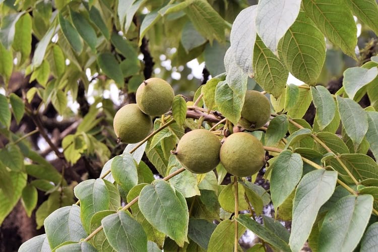
The fruits and leaves of manchineel tree resemble that of an apple tree. (Anne and David / Flickr)

A sign warning people to avoid contact with the manchineel tree. (Will Pollard / Flickr)
If you go to the Caribbean or to the regions around the Gulf of Mexico, you may come across thick clusters of mangroves along the shoreline. Amongst these trees, there will be the infamous evergreens known as the manchineel tree. The infamy comes from the fact that every part of this tree is extremely poisonous. All parts of the tree, including its bark, leaves, flowers, and fruits, contain toxins, some more powerful than others and some that have still not been identified. Coming in close contact with the tree can result in serious injuries and even fatalities. In many areas, the Manchineel trees are therefore painted with a red cross or a red band, along with notices to warn people to stay away from them.
The manchineel tree
The tree gets its name from manzanilla, which is Spanish for little apple. Spanish-speaking locals call it la manzanilla de la muerte or el arbol de la muerte, which, respectively, mean the little apple of death and the tree of death. Other popular names for the Manchineel are beach apple and poison guava. As the names might indicate, this isn’t a tree that the locals love and adore.
The Latin name for the Manchineel is Hippomane mancinella, and it belongs to the Euphorbiaceae or Spurge plant family that is spread all around the world in a variety of forms, ranging from shrubs to very tall trees. It may surprise you to know that the much-reviled Manchineel tree is a close relation of the popular Poinsettia. All plants of the Euphorbiaceae family have toxic sap. The level of sap toxicity varies, however, and the sap from some of the plants can be used for medicinal purposes; this is how Euphorbiaceae plant family came to be called Spurge, which is derived from the word purge, a reference to the laxative properties of the sap.
Physical characteristics of the manchineel tree
A flowering, evergreen, and a round-crowned tree that can reach up to 50 feet in height, the Manchineel has a reddish-grey bark and a trunk that can be around two feet in diameter. It has long-stalked, shiny, and elliptical leaves that are yellow-green in colour and about 10 centimetres in length. The leaves are simple, alternately arranged, and have serrated edges. The Manchineel produces small greenish-yellow flowers that appear in spikes. The fruit of the Manchineel resemble apples and are green or greenish-yellow when ripe. The hard stone inside the fruit contains six to nine seeds.

The manchineel tree. (Marianne Serra / Flickr)
Habitat of the manchineel tree
The Manchineel trees grow in sandy soil along the coast and in mangroves in brackish water and its deep-set roots are excellent for preventing soil erosion. It also serves as an effective windbreak.
Its habitat extends from the Caribbean to Northern, Central, and Southern America. In Florida, you will find the Manchineel in the mangroves of Flamingo in the Everglades National Park and around the Elliott Key and Key Largo islands. It is an endangered tree in the USA as most people would rather eradicate it than have such a toxic neighbour and also on account of rapid habitat loss.
The toxicity of the manchineel tree
While the Manchineel tree contains a variety of toxins, only some such as hippomanins, sapogenins, mancinellins, and physostigmines are known. Researchers still have to identify the others. Some of the toxins have an instantaneous effect, while others are slow to act.
The tree’s milky sap contains the organic compound, phorbol, of the diterpene family of esters. It is so toxic that even a drop of it on your skin can cause burns, blisters, and inflammation. The phorbol is also highly soluble in water. For these reasons, it is not advisable to stand under the Manchineel, and especially not when it rains. Contact with the sap can cause headaches, dermatitis, severe breathing problems, and eye-related problems.
The sap is so toxic; it can damage the paint on cars. Even burning the tree is dangerous as the smoke can poison you if you inhale it and it can also temporarily or permanently blind you.
As you might expect, the Manchineel fruits are not recommended for eating. While there are no reported deaths in recent times from eating the fruits, they could potentially be fatal. They are certainly hazardous enough. According to people who have tried them, the fruits taste delicious at first and then start to taste bitter and peppery. The person then experiences a burning sensation in the throat and the throat swells up and makes swallowing difficult. The pain is excruciating and can last up to eight hours. The person may suffer from gastroenteritis, bleeding, vomiting, shock, digestive tract damage, and bacterial infection. It may be necessary to hospitalize them. Some of the Manchineel toxins may even cause cancerous tumours.
Reason for the manchineel’s toxicity
Botanists remain mystified about why the Manchineel tree is so toxic to humans, animals, and birds. Only the iguana Garrobo (Ctenosaura similis), a striped, black-spined reptile of Central and South America, is known to eat the fruits and sometimes reside in the tree.

Ctenosaura similis. (Christian Mehlführer / Wikimedia Commons)
If you consider the issue from the evolutionary point of view, it is rather strange. Generally speaking, trees want other creatures to eat their fruits and thus help it to disperse and propagate their seeds. Since the Manchineel is so poisonous, there is no question of birds or mammals scrambling to eat it. How does it disperse its seeds then? In the same manner as the coconut tree. As the trees grow on coastal shores, they can easily drop their fruits into the water. These are then carried away by the water current and end up on another shore. The water rots the outer covering and the seeds germinate in the water-logged sandy soil and new plants spring up.
Uses of the manchineel tree
Despite its toxicity, the Manchineel tree is used to make furniture. The tree is burned at the base to topple it; you shouldn’t try cutting it with an axe as that can get the sap all over you. The cut wood is left to dry in the sun for several days to get rid of the toxic sap. Even so, it is necessary to be extremely careful while working with the wood. Wearing a mask is a must to avoid inhaling the sawdust.
Local people have traditionally used the Manchineel toxins from the dried fruits and extracted tree gum to make diuretics and medicines for edema.
In historic times, they used the Manchineel leaves to poison enemy water supplies and the Manchineel sap to tip their arrows for use in warfare. The Spanish conquistador Juan Ponce de León died after being shot with an arrow tipped with Manchineel in battle with the Floridan Calusa tribe. He first came to Florida in 1513 and then returned to seize it for Spain in 1521. His colonization attempt, however, did not go as expected. He met with fierce resistance from the Calusa warriors. One of them shot the sap-tipped arrow into Ponce de Leon’s thigh. The conquistador and his troops fled to Cuba and he died there on arrival.
Avoid the manchineel tree
It is not without reason that the Guinness Book of World Records has rated the Manchineel tree as one of the most dangerous trees in the world. If you should happen to encounter one, stay as far away as possible. This isn’t a tree you want to get up close and personal with.
Enjoyed this article? Also, check out “Rainbow Eucalyptus: A Stunning Demonstration of Nature’s Vibrant Art“.
Do you have a story for us?
We welcome your contribution at [email protected]. Please include your name, city, state, and country.
Fact Analysis:
STSTW Media strives to deliver accurate information through careful research. However, things can go wrong. If you find the above article inaccurate or biased, please let us know at [email protected].
RELATED
- August 30, 2018 Saving the Kakapo – The World’s Strangest Parrot
- November 20, 2019 Solifugae: Unique Creatures That Are Neither True Scorpions Nor True Spiders
- June 19, 2020 Tree of 40 Fruits: A Patchwork Canopy of Myriad Fruits
- May 16, 2020 Xylaria Polymorpha: A Macabre Mushroom that Resembles a Dead Man’s Fingers
The post The Manchineel Tree: One of the Most Toxic and Dangerous Tree in the World appeared first on .
]]>The post The Cano Cristales: Colombia’s Extraordinary River of Five Colors appeared first on .
]]>
River Cano Cristales. (Pedro Szekely / Flickr)
The Cano Cristales river is one of Colombia’s most spectacular natural wonders. Running for 100 kms through the Serranía de la Macarena National Park in Colombia, this incredible five-coloured river has its source to the south of the park and flows eastward to become a tributary of the Guayabero river. The colours of the rivers come from the Macarenia clavigera river weed that grows underneath the fast-flowing river water.
The three different ecosystems of the Andes mountain range, the East Llanos savannah, and the Amazon rainforest meet at the Serranía de la Macarena, making it one of the most biodiverse areas in Colombia. The Serranía de la Macarena includes over 500 species of birds, 1,200 species of insects, 100 species of reptiles, and over 2,000 species of plants. To protect this biodiversity, the Colombian government designated 6,200 square kilometres of the area as a national park in 1971.
The Cano Cristales river
In Colombia, the local populace refers to small rivers as pipes. With a width of 65 feet, the Cano Cristales river is a pipe. The water in the river is so pure and transparent that you can clearly see right down to the rocky riverbed. Along its length, you will encounter several waterfalls, deep pools, and caverns. The caverns are a result of centuries worth of steady erosion as the fast-flowing river water sped past the rocky faces.

Cano Cristales, Colombia. (Mario Carvajal / Wikimedia Commons)
The pools formed as a result of the enlargement of small pits in the rock bed. This enlargement came about from rock pieces grinding against the pit’s wall as the water current swirled the rocks around. The river water lacks the nutrients necessary to sustain aquatic wildlife, so there are no fish in the Cano Cristales. The colourful Macarenia clavigera is the only plant life in the river.
Macarenia clavigera
Macarenia clavigera is a river weed from the botanical plant family Podostemaceae. Native to subtropical and tropical climates, these river weeds grow underwater, clinging tightly to hard rock and stone beds in fast flowing rivers. Macarenia clavigera is known to exist only in Colombian rivers such as Cano Cristales and Cano Siete Machos in Meta department, and Cano Tranquilandia in Guaviare department.
The plant is rather fragile, with a thick, flexible stem that has thin, delicate, and cotton-thread-like leaves. It comes in various colours, the colour depends upon the amount of sunlight the plant is exposed to and the depth of water in which it is growing. In areas where there is a lot of sunlight, the plant can be seen in colours like pale pink, magenta, various shades of red, and deep purple. In shaded areas, the plant usually looks bright green and can appear to be blue, yellow, or orange coloured as well.

Macarenia clavigera river weed. (Peter Fitzgerald / Wikimedia Commons)
The geographic characteristics of Colombia such as its closeness to the equator and its wide range of altitudes ensure variable weather experience at different locations of the country throughout the year.
The rainy or wet season occurs in the months of April, May, October, and November. During this season, when water levels are high and hardly any sunlight reaches the depths of the river bed, the Macarenia clavigera is olive-coloured and is difficult to see in the water. In the dry and hot summer months of December, January, July, and August, the plant lacks the water it needs to colourfully thrive. It sheds its seeds in this season. New plants start to sprout in the following wet season, with the growing roots deriving nutrients from the minerals in the rocks in the riverbed.
From the beginning of August to the end of October, Macarenia clavigera finds the ideal amount of sunlight and water it needs to bloom in abundance, and it then colours the Cano Cristales with its vibrant hues. This picture changes practically every year, as the swift water current moves and alters the positions of river rocks to some extent and the river carves new paths through the rocks. Old trees fall in some areas and new trees proliferate thickly in other areas, creating new sunny and shady areas along the river. These changes affect the growth of the Macarenia clavigera and that, of course, affects the colours of the river.
Discovery of the Cano Cristales river
The indigenous people living in the area have known the Cano Cristales for centuries. The rest of world got to know of its existence only in 1969 when some Colombian cattle farmers went to explore the area and came across the river when Macarenia clavigera was in bloom. The discovery, however, did not lead to an influx of tourists trekking through the wilderness.
For many years, from 1964 to 2002, the war between the Colombian government and the FARC guerrilla armies made the area inaccessible to the general public. In the mid-2000s, the government was able to regain control of La Macarena and around 30 km of its surrounding area. While the government could not guarantee the safety of visitors beyond this area, the strong Colombian military presence in La Macarena made it relatively safe for adventurous tourists to visit the Cano Cristales river. The area became a popular tourist destination after air travel became possible in 2009. In 2017, the FARC disarmed themselves and the area has been at peace since then. There are now many hotels and restaurants in the area.
Environmental protection of the Cano Cristales river
A regional government agency called Cormacarena manages sustainable development in the area. Various communities residing in the area also take an active part in ensuring that the environment is not harmed. To protect the Macarenia clavigera plants and the river from pollution, the Columbian government has enacted and enforced several environmental laws.
They have made it mandatory for tourists to apply for a permit from the National Parks Office prior to visiting the Cano Cristales river, and they allow only 200 tourists to visit the area per day. Tourists must only visit in groups of up to seven people, and they have to be accompanied by an authorized guide. There is a ban on the use of sunscreen lotions and insect repellent sprays in the area. Swimming is limited to some designated areas of the river. From January to June, the authorities do not allow visits to the Cano Cristales river to ensure that the Macarenia clavigera plants can propagate undisturbed in these months.

Macarenia clavigera in Caño Cristales. (Pedro Szekely / Flickr)
Visiting the Cano Cristales river
As the photogenic Macarenia clavigera attracts more tourists, the Cano Cristales river is becoming popular as an ecotourism destination.
If you would like to visit the Cano Cristales river, you should head for La Macarena, a small town on the banks of the Guayabero River, right next to the National Park. There are direct flights from Bogotá, Villavicencio, and Medellín to La Macarena. From La Macarena, there are jeeps and boats to take tourists to the start of the hiking trails in the national park which lead to Cano Cristales. Tourists have to travel back to La Macarena in the evening; it is not possible to stay overnight as there are no campsites.
Enjoyed this article? Also, check out “Tsingy de Bemaraha National Park: Natural Beauty of Stone Forest in Madagascar“.
Fact Analysis:
STSTW Media strives to deliver accurate information through careful research. However, things can go wrong. If you find the above article inaccurate or biased, please let us know at [email protected]
RELATED
- August 28, 2019 Hoatzin Reptile Bird: A Dinosaur-Like Bird with the Digestive System of a Cow
- June 25, 2018 Tsingy de Bemaraha National Park: Natural Beauty of Stone Forest in Madagascar
- December 1, 2018 Mapogo Lions: The Six Legendary Lions That Meant ‘Bloody’ Business in Their Quest for Dominance
 July 28, 2018 Las Lajas Sanctuary: A Church with a Mysterious Mural Nobody Can Explain
The post The Cano Cristales: Colombia’s Extraordinary River of Five Colors appeared first on .
]]>The post The Moeraki Boulders of New Zealand: Naturally Formed Spherical Boulders from the Paleocene Era appeared first on .
]]>
Moeraki Boulders at Koekohe Beach, New Zealand. (Bernard Spragg. NZ / Flickr)
If you visit Koekohe Beach on the Otago Coast on the South Island in New Zealand, you will encounter enormous round boulders known as the Moeraki Boulders. They dot the landscape both in clusters and as single standing stones. Some of the boulders have tortoise shell type markings on them while others have split open to reveal hollow and sometimes colourful cores.
While these balls look like an alien might have spilled them across the landscape, they actually emerged from the mudstone cliffs due to erosion brought about by wind and wave action. As the cliffs continue to erode, we will find more Moeraki Boulders on Koekohe Beach.

Moeraki Boulders. (Krzysztof Golik / Wikimedia Commons)
Moeraki Boulders’ formation
According to researchers, it is likely that the Moeraki Boulders first formed from the seafloor mud over 56 million years ago in the Paleocene era.
The grey-coloured Moeraki Boulders are concretions. That is, their formation process came about from by layers upon layers of sediments depositing over one another and then cementing together with minerals. Over time, with the continued addition of cemented layers, the boulders grew to be very large in size. It took many million years for the large boulders to take shape, and the formation of a Moeraki Boulder was not dissimilar to the formation of a pearl in an oyster shell. As in the case of a pearl, the sediment layers began to form around an organic particle.
While at first sight, all the Moeraki boulders appear spherical, they are not all perfectly round. Some of the boulders have more ovoid shapes. In their sizes, the boulders vary considerably. You will come across some boulders that range in diameter from 1.6 feet to 3.3 feet while others have diameters of 4.9 feet to 7.2 feet.

A large Moeraki Boulder. (karlnorling / Flickr)
Researchers are not exactly sure how the spherical forms came about but offer different theories. According to one theory, the continuous effect of the waves against the rocks may have worn down and smoothed and rounded the rock surfaces. Another theory suggests that, during the boulder formation, the boulder received liquid mineral content in equal amounts from all directions around the core and this led to the spherical form of the boulder.
Some of the boulders have distinct cracks in them while some have broken open to reveal their hollow interiors. Researchers call the cracks in the boulders as septaria and they think that these septaria occurred shortly after the formation of the concretions. Of course, nobody knows exactly why these cracks happened, but there are different theories as to their cause. Perhaps they formed as a result of earthquakes, or because the concretion dried too fast. It may have been because the inner organic cores shrank and released gases that expanded and put pressure on the concretions, leading to the septaria.
In the boulders that have cracked open, researchers found that the inner hollow cores are weak compared to the very hard outer layers.

A cracked Moeraki Boulder. (Krzysztof Golik / Wikimedia Commons)
Maori legend about the Moeraki Boulders
If the scientific theories for the formation of the Moeraki Boulders seem somewhat mundane to you, the Maoris have a more colourful explanation.
According to Maori lore, the KähuiTipuatribe once decided to set out across the ocean to find Hawaiiki, a mythical land famous for its Kumara sweet potatoes. The KähuiTipua people wanted to bring back the sweet potato plants to grow them on their own land. So, they set off in the Arai TeUru, their double-walled waka; in the Maori language, waka means canoe.
On the way back, a fearsome storm overtook them, and the Arai Te Uru ended up wrecking itself at Shag Point just off the Otago Coast. Everything in the waka fell overboard and later, as the storm abated, some of this found its way ashore to Koekohe Beach. The eel baskets, water calabashes, and sweet potato kumaras ended up on the beach and became transferred into the Moeraki Boulders. The wreck of the waka, in turn, became a reef; you can see it if you visit the mouth of the Waihemo River.
Other colourful tales about the Moeraki Boulders
You’ve probably heard this one for other strange natural occurrences – it was the Aliens. According to some tall tale tellers, the Moeraki Boulders are the unhatched eggs that the Alien parents had to leave behind after an unsuccessful attempt to colonize the Earth. Other tall tale tellers claim that the boulders are unhatched dinosaur eggs and, if not that, then dinosaur poop, both solidified with layers and layers of sediments.
The western discovery of the Moeraki Boulders
Westerners discovered the Moeraki Boulders in the 1800s. A scientist and politician named Walter Mantell made a drawing of the beach strewn with the boulders in 1848. In this drawing, which you can now see in Wellington’s Turnbull Library, the boulders appear far more numerous than there are at present. This may be on account of the cracking of some of the boulders. The boulders, otherwise, are pretty tough and have managed to weather climatic conditions very well.
Visiting the Moeraki Boulders
Take State Highway 1 from Christchurch to Dunedin. The Koekohe Beach is in the South Island’s Otago region, about a one-hour drive from Dunedin, between the towns of Moeraki and Hampden. You can also drive over from Oamaru, which takes around 30 minutes, or from Cromwell, which takes a couple of hours. Leave your car at the car park at the Moeraki Boulders Scenic Reserve and walk to the beach.
There is no charge to visit the beach to see the Moeraki Boulders, but, note that, if you have the super strength to carry any of them away, you cannot legally do so. Previously, people often carried off the smaller boulders for garden decoration and other purposes. The area is now a protected sanctuary for boulders. You can clamber around them, but you can’t take them home.
If you are a photography enthusiast, you can have a grand time photographing the boulders. They offer some great photo opportunities, especially in the early morning hours and in the late afternoon. They also look great in stormy weather when the dark clouds are rolling overhead. It’s best to visit during low tide when you see all the boulders clearly and can walk up to them. If you go during high tide, you will see only some of their top portions. The MetService page can help you time your visit.
There are some nice accommodation options in Hamden and Moeraki if you want to stay in the area and explore the boulders and the beach some more.
Enjoyed this article? Also, check out “Penitentes – The Remarkable Ice Pillars of the Atacama Desert“.
Fact Analysis:
STSTW Media strives to deliver accurate information through careful research. However, things can go wrong. If you find the above article inaccurate or biased, please let us know at [email protected].
RELATED
 April 12, 2019 The Wave in Arizona: A Geological Wonder
- March 2, 2019 Wave Rock: Where a Massive Prehistoric Wave, Just About to Break, is Etched Permanently in Stone
- April 14, 2019 Fingal’s Cave: The Musical Geometry of Nature’s Domain
- August 31, 2020 Ennedi Plateau and Aloba Arch: Home to Exquisite Natural Formations and ‘Extinct’ Animals
The post The Moeraki Boulders of New Zealand: Naturally Formed Spherical Boulders from the Paleocene Era appeared first on .
]]>The post An Up-Close and Personal Encounter with the Alien-Like Pacific Barreleye Fish appeared first on .
]]>
Barreleye Fish or spook fish. (© 2004 MBARI)
From Goblin Sharks to Blobfish, Sea Cucumbers to Dumbo Octopi (and these names are not made-up) they look like something out of a Sci-Fi film set on a distant planet which is no doubt where many directors got their inspiration from. Another example of this – although with a more natural sounding name – is the Pacific Barreleye Fish. Perhaps a more appropriate name would be its other moniker – the Spook Fish – as this particular class of animal is the epitome of the above characteristics, being described by National Geographic with “…a head like a fighter-plane cockpit…”
In this case more than many others, a picture is worth a thousand words.
“The Barreleye… has extremely light-sensitive eyes that can rotate within a transparent, fluid-filled shield on its head. The fish’s tubular eyes are capped by bright green lenses. The eyes point upward… when the fish is looking for food overhead. They point forward when the fish is feeding. The two spots above the fish’s mouth are… olfactory organs called nares, which are analogous to human nostrils.”
Barreleye Fish: Sightings and research
The Barreleye fish was first discovered in 1939 but extremely little was known about the newly-found species due to its natural habitat being so deep below sea level. Barreleyes had to be brought to the surface using nets meaning that their daily rituals could not be observed as the creature would ultimately die on surfacing. Alas, this was the only way because sensitive video cameras which are effective underwater were not as accessible in those times and those that were stayed on more pressing missions. Accessible cameras did not have the ability and strength to handle the intense underwater pressure.
More would be revealed as technology improved, especially in 2008 when teams at the renowned Monterey Bay Aquarium Research Facility were tasked with examining the mysterious fish. MBARI was founded in 1987 by the US former Deputy Secretary of Defense David Packard. As the name suggests, the research facility is situated at Monterey Bay, California, one of the most biologically-diverse stretches of ocean in the world and home to a winding 4,000 meter deep canyon where many of these organisms reside. David Packard outlined the duty of MBARI,
“The mission of MBARI is to achieve and maintain a position as a world center for advanced research and education in ocean science and technology, and to do so through the development of better instruments, systems, and methods for scientific research in the deep waters of the ocean. MBARI emphasizes the peer relationship between engineers and scientists as a basic principle of its operation. All of the activities of MBARI must be characterized by excellence, innovation, and vision.”
What MBARI found
The most incredible feature about the fish is in the name – having tubular, barrel-shaped eyes. These were not appreciated when the species was first detected, reportedly because the fragile fluid-filled dome which holds the eyes was destroyed whenever they were brought to the surface. Many even believed that the two eye-shaped holes at the front were eyes (an easy mistake to make) yet they are nares – most similar to nostrils. New information came to light when MBARI was finally able to film the fish underwater, swimming unperturbed in its natural locale.
MBARI used remote cameras to research the fish off the shore of California. The fluid-filled head was observed, as were tubular eyes, able to see within the transparency of the fluid, even rotating to allow the fish to look up. This is vastly important as they can catch the silhouettes of prey under the sun, essential, considering it is almost pitch-black underneath and around. The eyes have binocular vision because of their close proximity (unlike the majority of fish species) and indeed point in the same direction but this actually improves depth perception. This not only includes picking objects out from a distance but even the glowing bioluminescence of minuscule prey. Their eyes are not the only evolutionary wonders; flat fins allow them to stay motionless in the water to conserve energy, retaining their strength for feeding time.
Although having a very small mouth with no teeth they have large stomachs for their size. Spook fish are known to consume a vast amount of the mainly jelly-like substance creatures of the Phylum Cnidarian. They have been observed to maneuver around Siphonophores (a type of Cnidaria characterized for their stinging tentacles) and actually steal food from them. The fluid in their head protects them from any stings.
The importance of studying biodiversity
A quick glance at the Barreleye Fish illustrates how fundamental it is that animals such as these are studied. That is, if no harm, distress or disorder comes to them, it goes without saying. They appear so dissimilar to the majority of other species that it is vastly possible that they hold unique features unbeknown to mankind as well as potential keys to unlock mysteries about our world. The oceans of Earth have become a stark warning to the problems of pollution producing harrowing images about the abject conditions of some areas. They are a sickening reminder of these issues and how wicked a way that humans have distressed the planet.
The little Barreleye is a charming reminder and a much-needed beacon towards the beauty that still remains in the blue, seemingly so deep to be disturbed by the chaos above it. We hope this is the case and that we can clean up our act before the Barreleye and its brethren in the murky depths are affected too. These wonderful creatures may have the ability to help us but only if we help them first.
Here is a video link to the utterly-majestic yet alien-like Pacific Barrel Eye Fish.
Enjoyed this article? Also, check out “Sarcastic Fringehead: Most Quarrelsome Fish That Has a Big Mouth“.
Fact Analysis:
STSTW Media strives to deliver accurate information through careful research. However, things can go wrong. If you find the above article inaccurate or biased, please let us know at [email protected]
RELATED
 February 28, 2019 Under the Sea: Do Fishes Dream?
- June 1, 2019 Sea Cucumber: The Modest Marine that Needs to be Protected
- May 26, 2020 A Strange Predatory Link Between Killer Whales and Moose
- November 4, 2019 Goblin Shark: The Alien Shark of the Deep Sea, with a Slingshot Mouth
The post An Up-Close and Personal Encounter with the Alien-Like Pacific Barreleye Fish appeared first on .
]]>The post The Silky Anteater: The Nocturnal Dweller of the Tropical Rainforests appeared first on .
]]>
Silky anteater. (Quinten Questel / Wikimedia Commons)
If you ever visit the tropical rainforests of Central and South America or Trinidad, you may want to scan the canopy of the towering trees and try to spot a silky anteater. The chances are high that you won’t see one, certainly not during the day. You might get lucky at night-time though and see one of them clambering from branch to branch in search of food. Silky anteater are nocturnal creatures, and they also prefer travelling across the tree canopies rather than descending to walk on the ground.
In 1758, the Swedish naturalist, Carolus Linnaeus, gave the silky anteater its Latin name, Cyclopes didactylus. The translation is circular feet with two toes. The silky anteater clings to branches by circling its limbs around them. It also has two large and sharp claws on each of its forepaws.

The giant anteater. (Fernando Flores / Flickr)
The silky anteater belongs to the Vermilingua suborder. This suborder includes other anteaters such as the Giant Anteater (Myrmecophagatridactyla), the Northern Tamandua (Tamandua Mexicana), and the Southern Tamandua (Tamandua tetradactyla). Vermilingua, incidentally, means worm tongue in Latin and refers to the anteater’s long, narrow, and sticky tongue that it uses to gather up ants. As you might have guessed from the name, these are the anteater’s main food.
Species of the silky anteater
In 2017, scientists carried out mitochondrial and DNA review of 287 Cyclopes specimens and concluded that, in addition to four existing species, the genus consists of three new species. The existing Cyclopes species are Cyclopes didactylus, Cyclopes ida, Cyclopes catellus, and Cyclopes dorsalis. The three new species are Cyclopesthomasi, Cyclopes rufus, and Cyclopes xinguensis.
Habitat of the silky anteater
You will find the silky anteater in the tropical rainforests of Central and South America. Their habitat ranges from Oaxaca and Veracruz in southern Mexico to Brazil, Peru, Panama, Bolivia, and Ecuador. Silky anteaters with golden pelts occur on the north side of the Andes, while the darker silky Anteaters reside on the south side.
The silky anteater also lives in Trinidad, and the local people call it ‘Poor Me One.’ Apparently, the locals mistook a forlorn bird cry to be that of the silky anteater and assumed it was bemoaning its lonely status. The silky anteater is a rather silent creature in general. However, it is capable of uttering high-pitched and shrill shrieks in adverse situations.
The silky anteater is a protected species, but researchers don’t consider it endangered. Its environment, however, is under threat from human activities.
Physical characteristics of the silky anteater
Also known as the Pygmy Anteater, the silky anteater has a thick, silky pelt that can range in colour from golden to brown to grey. There is a stripe of a darker shade on its back, running from the shoulder to the rump, and the coat on the underside may be of a paler hue.
It weighs up to 500 grams and measures around 45 centimetres in length. It has a prehensile tail – that is, a tail that can be used to curl around and hold onto branches and other objects – that extends its length by another 26 centimetres. It possesses a short snout, large black eyes, tiny ears that are well-hidden within the thick fur, and red soles.

Silky anteater balancing on a stick. (The Field Museum Library / Flickr)
Along with the two large, sharp claws on each of its forepaws, it has four smaller claws on each of its hind legs. These claws are the silky anteater’s defence against predators and attackers.
Behaviour of the silky anteater

A stuffed silky anteater in a museum. (Totodu74 / Wikimedia Commons)
When it feels threatened, the Pygmy Anteater rears up on its hind legs and holds its front paws before its face like a boxer. The idea is to punch and puncture the would-be attacker. It is not a good defence. The silky anteater is a peace-lover, not a fighter, and it is also a slow-moving creature. If spotted by its principal enemies, Harpy Eagles and Hawks, it is, unfortunately, an easy victim. The birds swoop down and grab it, not giving it a chance to defend itself.
To protect itself from these predators, the Anteater often hides in silk cotton trees. It is preferable than getting into a fight. The pods of these trees have thick fibres that resemble the pelt of the silky anteater, and this makes camouflaging itself in these trees easier.
To return to the topic of the claws, you would think that they might be a hindrance in walking on the ground. The silky anteater, however, turns them inward and walks on the sides of its feet. Since it doesn’t walk on the ground too often and certainly not over long distances, it works out well. If it has to travel far, it does so across the tree canopies. Males have larger ranges than females. They forage and live on their own, but their ranges can overlap. Silky Anteaters breed twice in a year, and the females give birth to one young one at a time. Both parents care for the baby and, carrying the baby on the back, move them from one tree hollow to another almost daily to keep them safe from predators.
The silky anteater’s claws and the prehensile tail are convenient for climbing trees and anchoring itself to branches while it eats. The claws can also break anthills, ant nests, and branches to get the insects. From sunset till dawn, it can devour up to 8,000 ants. It uses its long, thin tongue, which has spikes and mucus, to gather up the ants. In addition to ants, it eats termites, beetles, and fruit. The tongue is also useful for licking moisture from leaves. Despite all the feeding, according to researchers who took the trouble to find out, the silky anteater only has one bowel movement in 24 hours.
When it’s done eating, defecating, and hiding from predators, the Silky Anteater curls up into a ball in a roughly made nest of leaves and sleeps during the day.
Enjoyed this article? Also, check out “Proboscis Monkey: The Rare Borneo Monkey Species with an Unusually Long Nose to Lure Its Females“.
Fact Analysis:
STSTW Media strives to deliver accurate information through careful research. However, things can go wrong. If you find the above article inaccurate or biased, please let us know at [email protected].
RELATED
- December 1, 2018 Mapogo Lions: The Six Legendary Lions That Meant ‘Bloody’ Business in Their Quest for Dominance
- January 8, 2019 Proboscis Monkey: The Rare Borneo Monkey Species with an Unusually Long Nose to Lure Its Females
- February 28, 2019 Under the Sea: Do Fishes Dream?
 December 25, 2018 Jack the Baboon Once Served as a Railway Employee for 9 Years and Didn’t Commit a Single Mistake
The post The Silky Anteater: The Nocturnal Dweller of the Tropical Rainforests appeared first on .
]]>The post Wave Rock: Where a Massive Prehistoric Wave, Just About to Break, is Etched Permanently in Stone appeared first on .
]]>
Wave rock. (Pxhere)
Australia is a land full of surprises. Right from being home to strange animals to unusually-formed natural structures, Australia has it all. There are so many naturally-occurring prehistoric formations in the country that an entire year’s trip Down Under wouldn’t be enough to check out all of those. Apart from the many rare structures found here, there’s one odd-shaped rock that has wowed more than half the world’s population in all these years. The Wave Rock in Western Australia, as the name suggests, is a unique-shaped, natural rock formation, which is a true beauty present in its natural form.
The appearance of the wave rock
One look at it and people are sure to imagine that a huge wave, just about to break, has turned to stone and frozen in time. But that is not the case in reality. Nestled close to the small town of Hyden in Southwest Australia, this rock formation, also known as the Hyden Rock, in the shape of a huge crashing oceanic wave is actually an inselberg. Rising straight out of the earth in isolation, this rock is estimated to be around 2.7 billion years old and made up of ochre, red and grey granite stone.

Wave rock from above. (Brian W. Schaller / Wikimedia Commons)
Around 300 kilometres from the southeastern city of Perth, the Wave Rock rises up to a height of about 49 feet and runs approximately 330 feet in length. The remarkable red, yellow and grey colours of the wave are a result of the minerals that have trickled down the slope due to the rains that keep lashing the structure over and over again. It is one of Australia’s most cherished natural marvels, which has kept geologists busy for years, studying its formation and rock composition.
How did the rock form into a wave-like structure?
Geomorphologists that have been studying the Wave Rock closely for years are of the opinion that the inselberg has taken a beating and suffered erosions over the centuries. This sedimentary activity has left nothing but a rounded projection hanging from above the cliff. What is more surprising is the fact that the wave formation is only on one side of the rock, which scientists have termed a flared slope. A flared slope is a stone or rock formation (mostly made up of granite) where the rock wall is solid on one side, while it is concave on the other side because of the damage suffered due to exposure to rough weathers over all the millennia. There are many other such examples of this kind of a structure in the world, but none is said to be as fascinating as the Wave Rock in Australia.

Wave rock. (dilettantiquity / Flickr)
Dam on top of the Wave Rock
It is believed that the Aboriginals that set foot in the country, were the first ones to discover the oversized Wave Rock, but nothing more concrete is recorded about this part of the history yet. Although the Wave Rock is a natural surf-like formation, a stone wall was built on top of the gigantic rock in the year 1928 by the Australian Public Works Department to collect rainwater. Revamped in the year 1951, the method of rainwater harvesting on the dam served as the only source of water to the nearby dry areas and the stone wall on top of the Wave Rock, channelled towards a dam, continues to provide abundantly for the arid regions till date.
Other features nearby the structure
A variety of flora and fauna can be found near the Wave Rock. Wildflowers, an assortment of orchids, fame grevillea and particularly the acacia plant are very common to the area. A host of animals and birds, mostly endemic to Australia have also been spotted in the Hyden Wildlife Park, including wombats, kangaroos, emus, koalas and wallabies. The wildlife surrounding the Wave Rock is said to keep the area bustling with life and sounds.
One can even climb to the top of the granite wave to enjoy a panoramic view of the town of Hyden just three kilometres away from the rock. The awe-inducing shape and size of the Wave Rock pulls in a flock of tourists to this place every year. The astonishing Wave Rock is now a part of the 160-hectare natural reserve in the Hyden Wildlife Park, where visitors from all over the world come to witness an enormous wave just about to crash that might destroy everything in its path, had it been part of the ocean instead of stone.
Enjoyed this article? Also, check out “The Wave in Arizona: A Geological Wonder“.
Fact Analysis:
STSTW Media strives to deliver accurate information through careful research. However, things can go wrong. If you find the above article inaccurate or biased, please let us know at [email protected].
RELATED
- April 12, 2019 The Wave in Arizona: A Geological Wonder
- August 31, 2020 Ennedi Plateau and Aloba Arch: Home to Exquisite Natural Formations and ‘Extinct’ Animals
- September 19, 2018 Fairy Circles: The Systematic and Symmetrical Circular Arid Grass Formations
- March 23, 2019 The Moeraki Boulders of New Zealand: Naturally Formed Spherical Boulders from the Paleocene Era
The post Wave Rock: Where a Massive Prehistoric Wave, Just About to Break, is Etched Permanently in Stone appeared first on .
]]>The post Lake Baikal: The World’s Deepest Lake That Holds 22-23% of the World’s Freshwater appeared first on .
]]>
Lake Baikal. (W0zny/Wikimedia Commons)
Lake Baikal is the world’s oldest and deepest lake, and it also has the distinction of having the clearest water. It holds around 20% to 23% of all the freshwater that is present on earth. The water volume contained in Lake Baikal – around 23,600 cubic kilometres of water – equals to the water volume of all the Great Lakes in North America.
Lake Baikal: The world’s largest freshwater lake
Estimated to be around 25 or 30 million years old, Lake Baikal is a rift lake in a valley formed by the Baikal Rift System. That is, the lake came into existence due to the geological movements of the earth’s tectonic plates. Due to the movement of the plates, earthquakes are common in the region, and the lake boundaries continue to expand. Some researchers predict that if Lake Baikal continues to expand it will become an ocean. This, of course, could take many hundreds or maybe more years, since the annual rate of expansion is infinitesimal.
If you want to visit Lake Baikal, you will have to head for Siberia, to a mountain and Taiga bound region that lies between the Buryat Republic on the southeast and the Irkutsk Oblast on the northwest. The Baikal Mountains and the Barguzin range stand guard on two sides and the rest is the open Taiga (which is known as boreal forest or snow forest). The largest, nearby city is Irkutsk.
More than 300 rivers and streams drain into Lake Baikal, the most prominent ones of these being the Selenga River, the Snezhnaya River, and the Barguzin River. Lake Baikal itself, however, only has one outlet and drains out only into the Angara River. This river, in turn, flows into the Yenisei River and eventually joins the Arctic Ocean.

The crystal clearwater of Lake Baikal. (Max Dawncat / Wikimedia Commons)
The waters of Lake Baikal have an astounding clarity – it is clean, transparent water that has a very high oxygen content. This is due to the presence of a large number of aquatic organisms that purify the water continuously. In winter, if you look down the parts of the lake that are still unfrozen, you can see down to a depth of 130 feet. In summer, you can see down to a depth of 46 feet. The clarity comes from pure melted ice water, an absence of mineral salts in the water, and the presence of debris eating organisms.

Lake Baikal during winter. (Max Pixel)
From January to May-June, the lake waters remain frozen, with ice as thick as 6.6 feet in some areas. Unless you wear appropriate warm winter clothing, however, you could put yourself in danger of getting frostbite and hypothermia from the cold winds that blow unimpeded over the frozen lake. In winter, the water is the coldest right under the ice, and in summer, the sun warms the water at the surface and, since it cannot reach the depths, the water there is coldest in the summer months.

Lake Baikal from space. (NASA / Goddard Space Flight Center)
In windy and stormy weather, the lake can send up high waves, more than 30 feet high.
At its maximum depth, Lake Baikal goes down to 5,387/5,354 feet. It is 79.5 kilometres wide at its widest point and is 636/640 kilometres long. It has a surface area of 31,722 square kilometres. There are 27 islands in the lake, and most of them are uninhabited. The largest island is Olkhon, which is 72 feet long. About 1,500 people live on it.
Biodiversity in the Lake Baikal region
Known as the Russian Galapagos, the Lake Baikal region is one of the richest and most biodiverse regions in the world and is home to over 3,700 plant, bird, and animal species. At least 80% of these species are endemic to Lake Baikal. That is, they are unique to the region and you won’t find them anywhere else. Take the Nerpa seal, for instance, which is the only freshwater seal in the world, and the Golomyanka fish, which does not have any scales.

Baikal seal. (Per Harald Olsen / Wikimedia Commons)
The Omul fish, which has commercial fishing value and which consumers consider a rare delicacy; is now on the endangered list. The decline in the omul fish populations is due to excessive fishing, poaching, droughts that decrease the water level and its nutrient content, rise in water temperatures – the Omul is a fish that only thrives in icy-cold waters.
There are over 50 fish species, over 300 bird species, and over 100 types of worms, molluscs, and other invertebrates that make Lake Baikal their home; the worms, molluscs, and invertebrates help to purify the lake water and keep it well-oxygenated. Other animals found in the region include bison, elks, Siberian roe deer, boars, bears, wolves, foxes, sables, ermines, and minks.
The native tree species include cedar, fir, spruce, and Angara pine. Some of the trees in the area are over 800 years old.
Lake Baikal’s biodiversity remained protected for so long due to its geographical isolation from the rest of the world and so you can learn much about evolutionary science by studying the species here. In 1996, UNESCO listed the Lake Baikal region as a World Heritage Site.
History of Lake Baikal
Indigenous, nomadic people have inhabited the area around Lake Baikal for centuries. Their main source of revenue has always come from raising goats, sheep, cattle, horses, and camels, but, in the past, they were infamous for supplementing their income by raiding Chinese and Russian mainland settlements.
The Kurykans, who are the ancestors of the Buryat and Yakut people, lived in the area in the sixth century. The Han dynasty fought a war for 200 years with the Xiongnu tribal confederation in the region and stumbled upon the lake. They thought it was a sea.

Buryat of Olkhon Island. (Аркадий Зарубин / Wikimedia Commons)
In 1643, the Russian explorer, Kurbat Afanasyevich Ivanov, discovered Lake Baikal, and other Russian explorers and adventurers soon followed. They built outpost forts and tried to bring the region under their control. This was easier said than done, and there were frequent conflicts with the indigenous tribes who wanted to continue their traditional way of life and did not want any newcomers to settle in the region, particularly newcomers that wanted to take over and rule over them. Like it or not though, they and their region soon became a part of the Russian Empire in the 17th century.
When the Russian government built the Trans-Siberian Railway between 1891 and 1916, the engineers constructed 200 bridges and 33 tunnels on the southwestern side of Lake Baikal. Most of Siberia’s population resides along this railway line. Siberia is a huge region, making up about 77% of Russia, and, due to its brutal winters and harsh landscape, only certain parts of it are habitable.
The Red Army fought with the Czechoslovak legion near Lake Baikal in 1918.
In 1920, the Tsarist General Vladimir Kappel and his White Russian Army, which the advancing Communist forces had put to rout, marched across the frozen Lake Baikal in the dead of winter. Many of the soldiers died from wind exposure during this march, which became infamous as the Great Siberian Ice March. The White Russian Army had to leave their dead behind and the corpses froze where they fell and remained there until the lake thawed in the spring.
Research on Lake Baikal
There is plenty to research still in the Lake Baikal region. Since the area remained perfectly preserved for millions of years, researchers can collect natural data that can provide them with a better understanding of how the climactic conditions developed here.
The lake may have formed due to seismic activity that fractured the earth’s crust and widened an already existing riverbed. It is possible that the formation of the lake’s basins occurred at different times over a period of several million years, and perhaps several small lakes combined to form the present Lake Baikal. One of the most recent geological formations is the Proval Bay which came into existence after an earthquake in Tsanaskoe in 1862.
Researchers think that the lake’s underwater volcanoes release gases into the water. This phenomenon may explain why the dark circles that often appear on the ice that forms over the lake surface. According to the researchers, these circles are a result of the released gas bubbles bursting against the ice sheet. The gases may also explain the mass deaths of fish like Sockeye Salmon, Whitefish and Cisco in areas far from the industries; that is, in areas where there isn’t that much industrial waste to cause such deaths.
Some researchers think that the gases may also be responsible for the frequently reported sightings of glowing orbs floating above the lake surface. The locals think that the orbs are evil spirits warning people to stay away from the lake, but there may be a more scientific explanation. The orbs may be the result of the spontaneous ignition of natural methane gas. However, the researchers have not so far found any concrete evidence of this. The locals, meanwhile, claim it could be UFOs and Aliens.
The Russians have sent the Mir I, Mir II, and other manned deep-water submersibles to map and study the bottom of Lake Baikal. The researchers found a large number of gas hydrates throughout the lake, in the depths as well as in the shallows. Gas hydrates are water-based, ice-like particles that contained trapped gases. They are an unusual find in freshwater lakes. Gas hydrates may prove to be valuable as a fuel source, or so the researchers hope, since you can get 160 to 180 cubic metres of natural gas from heating 1 cubic metre of gas hydrate.
The Baikal Deep Underwater Neutrino Telescope has been carrying out neutrino research in the lake since 1993.
Some researchers think that Lake Baikal is slowly becoming an ocean. This is because the shift in the tectonic plates under the lake is expanding the lake’s boundaries.
There is much still that we don’t know about Lake Baikal.
Threats to Lake Baikal
Lake Baikal has faced several environmental threats over the years. The Baikalsk Paper and Pulp Mill, constructed in 1966 and maintained on the lake shore over the protests of scientists and local people, released chemicals from the paper-making process into the lake for over 40 years. The factory went bankrupt in September 2013, putting around 800 people out of work, but it was a blessing for Lake Baikal. The Russian government is planning on setting up an Expo Centre for the Russian Nature Reserve on the site of the factory.
There are other industries nearby that also discharge waste into the lake. The industrial waste pollution has exacerbated the growth of the invasive Spirogyra algae that feed on the waste and have proliferated rapidly in the lake. The toxic algae are destroying the lake’s ecosystem and killing water snails, sponges, fish, crustaceans, and other organisms that clean the lake waters. When the algae wash up on the lake shore, they have an incredibly foul stink, almost like that of dead, decaying bodies.
The uranium enrichment centre in Angarsk, 95 kilometres downstream from Lake Baikal, stores radioactive uranium that will prove to be very toxic to humans, animals, and the environment if it leaks and gets into the water bodies. Protesting environmental activists strongly pointed this out, but the Russian government ignored them.
In 2006, environmental activists succeeded in convincing the Russian government and the Russian oil pipelines state company Transneft to change the route of an oil pipeline that would, otherwise, have crossed very close to Lake Baikal in the north. There was a high chance it would have adversely impacted the environment there.
The construction of Mongolian hydro plants may affect the inflow of water from the Selenga River into Lake Baikal. Given that this river supplies Lake Baikal with almost 50% of its water, the lake water levels are likely to go down after Mongolia builds the river dams. This could result in more sediment deposits on the lake bottom and lead to habitat problems for the lake’s wildlife.
Lake Baikal in popular culture
Lake Baikal holds a special place in the hearts and minds of Russians, and the lake is mentioned in many popular folk songs. Two of these are – ‘Glorious Sea, Sacred Baikal’ and ‘The Wanderer.’
It was almost always referred to as a sea rather than a lake. A popular folklore term for it is the ‘Sacred Sea.’
According to local folklore, Jesus Christ visited the Lake Baikal region and was singularly unimpressed by its southern part. He exclaimed that there was nothing there, and that is why corn doesn’t grow in Dauria steppes. Another popular story puts Olkhon island as the birthplace of Genghis Khan.
The Russian government declared Lake Baikal as a special economic zone and has been encouraging the growth of the tourism industry here since that will create many job opportunities for the local people. Both domestic and international tourists visit Lake Baikal. The official annual figure is more than 500,000. They mostly stay in Listvyanka, Turka, and other settlements. While this may be good for the local economy, the same cannot be said about Lake Baikal. Tourists, unfortunately, leave a great deal of waste that adds to the growing pollution in the region.
Enjoyed this article? Also, check out “Pink Lakes: Where Rose-Tinted Lakes Surrounded By Lush Greenery Are Truly a Sight to Behold“.
Fact Analysis:
STSTW Media strives to deliver accurate information through careful research. However, things can go wrong. If you find the above article inaccurate or biased, please let us know at [email protected].
RELATED
- January 15, 2019 Pink Lakes: Where Rose-Tinted Lakes Surrounded By Lush Greenery Are Truly a Sight to Behold
- April 9, 2018 Dallol, Ethiopia: Alien World on Earth
- February 10, 2019 Ladakh Beckons You for a Riveting Tour of Nubra Valley
- July 17, 2019 The Lonar Lake: An Astronomical Marvel
The post Lake Baikal: The World’s Deepest Lake That Holds 22-23% of the World’s Freshwater appeared first on .
]]>The post Devils Hole: The Only Wild Habitat in the World Where the Endangered Devils Hole Pupfish Are Found appeared first on .
]]>
Devils Hole in Nye County, Nevada. (NPS photo)
Devils Hole in Nye County, Nevada, is home to one of the most extraordinary species of fish known as the Devils Hole Pupfish or the Cyprinodondiabolis. Measuring about an inch to three inches in length, these fish exist only in this particular habitat in the wild. They are also the only fish found in the Devils Hole geothermal pool. At present, they are on the verge of extinction and the Nevada Department of Wildlife is taking strong measures to conserve their population and extend it by captive breeding.

Devils Hole pupfish. (NPS photo)
The Devils Hole geothermal pool
Fed by aquifers and with a water temperature of 33-degree C, the Devils Hole geothermal pool in the Mojave Desert doesn’t appear to be a likely place to sustain life. It is found in the Mojave Desert in the 40-acre Death Valley National Park in the Ash Meadows National Wildlife Refuge in Nye County, Nevada in the United States. Formed in a fissure in the Cambrian carbonate rock, it lies around 49.21 feet below the surface. Its position ensures that it receives very little direct sunlight and it is dim inside the limestone cavern.
The surface area of the pool is around 11.48 feet by 72 feet. There is a shallow rocky shelf at one end that measures 16 feet by 11.48 feet and has a depth of 9.84 feet. From this shelf, the pool’s depth plunges down to 436 feet. It could be even more, but the caverns haven’t been fully mapped so far.

Devils hole. (Pacific Southwest Region USFWS / Flickr)
Seismic activities in far off places have a decided effect on the pool. When there are earthquakes in Mexico, El Salvador, Chile, and even Japan and Indonesia, they apparently cause underground tsunamis in the Devils Hole pool. The pool water recedes and then rushes back in forcefully.
The Devils Hole pupfish
The shallow rocky shelf in the pool is home to the tiny and short-lived Devils Hole Pupfish; they have a lifespan of only one year. The fish mainly live near the surface on the rocky shelf, at a depth of 1.14 feet, and feed on the Spirogyra and Plectonemaalgae that grow on the rocky sides of the pool, but scuba divers have also observed them at a depth of 60 feet in the pool’s deeper section.
The male fish have an iridescent bluish tinge and the females have an olive-green tinge. They got the name ‘Pupfish’ on account of their tendency to frolic in the water. The fish lay eggs and spawn throughout the year, but the population follows a seasonal cycle, with a higher number of fishes seen between April to June than in November.

Devils Hole pupfish. (Pacific Southwest Region USFWS / Flickr)
Nobody knows exactly how these tiny fish came to be in the Devils Hole pool, but the assumption is that they may have come some 10,000 years ago when the water level was up to the surface lip and there were streams flowing into the pool. At the end of the Ice Age, the ice retreated, the surface streams dried up, and the fish found themselves isolated in the pool, with no way out.
Over the centuries, the fish have adapted and thrived in the high temperature, high salinity, and low oxygen content of the water in the Devils Hole pool.
In recent years, however, the once thriving population has gone into a serious decline and if that trend continues, they might very well become extinct.
Reasons for the Devils Hole pupfish decline
There may be a variety of reasons for this drastic decline in the Devils Hole Pupfish population. The inbreeding factor is one reason. Since the end of the Ice Age, the trapped Pupfish population could only breed with one another and that may have led to defective DNA in later generations.
Another possible cause may be the rise in water temperatures which makes it difficult for the fish eggs to survive and which also adversely affects the growth of the algae on which the fish feed.
The tsunami-causing earthquakes also cause a decline as the waves they generate sweep away fish eggs and larvae from the shallow rocky shelf.
The Devils Hole pupfish declared endangered
In 1967, the Devils Hole pupfish joined the Endangered List. This came about thanks to the lobbying of the ichthyologist, Carl Hubbs, who convinced President Trumanin 1952 that they had to save both the Devils Hole Pupfish and their unique habitat. Earlier, in November 1954, the National Speleological Society sent scuba divers into the pool to carry out the first ever count of the Pupfish and they counted around 300 individuals.
Given that there were only a few hundred of them in the pool and as this was their only habitat – the smallest, by the way, of any known vertebrate animal on Earth – the possibility of their extinction was very real. In the 1970s, the US government formed the Pupfish Task Force and the Desert Fishes Council to protect the fish, and the US Supreme Court ruled that private companies could not pump out groundwater from the area as that led to a fall in the level of the Devils Hole pool water and affected the well-being of the fish.
Conservation efforts to save the Devils Hole pupfish
Saving the Devils Hole Pupfish is a tricky proposition as there are very few remaining individual fish and they have adapted over thousands of years to exist only in this unique habitat.
For conservation purposes, the Park Service researchers have been removing some of the eggs, larvae, and adult Pupfish to a specially prepared aquarium at the Ash Meadows Fish Conservation Facility where the conditions of the original habitat have been recreated as closely as possible. They first moved the eggs to the facility in April 2013 and these have since successfully hatched, and the researchers reported in November 2013 that the larvae were feeding and growing.

Devils Hole pupfish in a specially prepared aquarium. (Pacific Southwest Region USFWS / Flickr)
They remove no more than six adult fish in a year as harvesting more than that has shown to have a deleterious effect on the overall population.
Under the assumption that changes in the temperature of the pool water may have reduced the natural food of the Devils Hole Pupfish, the Nevada Wildlife Department’s National Park Service has been feeding them to sustain them and, hopefully, halt their population decline.
They have installed natural as well as artificial hideouts on the shallow shelf on which most of the Pupfish live to increase the survival chances of the Pupfish eggs and larvae, and they check on these at two-weekly intervals.

Devils Hole pupfish breeding facility. (Pacific Southwest Region USFWS / Flickr)
The researchers intend to replenish the Devils Hole Pupfish population with the captive-bred fish and to establish refuge populations in other locales to prevent their extinction. Raising the fish for too long or in entirety in captive conditions is not ideal as they become domesticated and lose the behavioural traits that allow them to be self-sufficient enough to survive in the wild.
Enjoyed this article? Also, check out “Devils Tower in Wyoming: A National Monument and a Geological Wonder“.
Fact Analysis:
STSTW Media strives to deliver accurate information through careful research. However, things can go wrong. If you find the above article inaccurate or biased, please let us know at [email protected].
RELATED
 June 3, 2018 Dasht-e Lut: A Martian Terrain and the Hottest Place on Earth
- September 19, 2018 Fairy Circles: The Systematic and Symmetrical Circular Arid Grass Formations
- May 1, 2019 Devils Tower in Wyoming: A National Monument and a Geological Wonder
 July 10, 2018 Solving the Mystery Behind the ‘Sailing Stones’ of Racetrack Playa
The post Devils Hole: The Only Wild Habitat in the World Where the Endangered Devils Hole Pupfish Are Found appeared first on .
]]>The post Ladakh Beckons You for a Riveting Tour of Nubra Valley appeared first on .
]]>
Nubra Valley in Ladakh, India. (Navaneeth Kishor / Flickr)
Ladakh is a part of India’s border state of Jammu and Kashmir. It is a mountainous cum desert region lying between two mountain ranges, Kun Lun in the north and Himalayas in the south. Its population is a mix of Tibetan Buddhists (39.7%), Hindus (12.1%) and Muslims (46.4%). A fulsome feel and exciting interface with its Indo Aryan and Tibetan descent, cultural diversity, and natural bounties can be experienced at the Khardung La Pass, Diskit Monastery, Maitreya Buddha Statue, Hundur Monastery, Yarab Tso Lake, Panamik village, and the Samstanling Monastery. A trip to the Nubra Valley situated 10,000 feet above the sea level in the northeast of Ladakh is your passport to visit all these places and much more.
Nubra Valley, Ladakh
At a distance of 150 Kms north from Leh, Nubra Valley is a tri-armed (Y-shaped) valley, formed by the river Shyok (a tributary of the Indus) and Nubra (also called Siachin River). Surrounded by snow-capped Himalayan range, it looks like a backdrop of the moon in winter. Hence the valley is also referred to as “Broken Moon Land’.

Nubra Valley. (alex hanoko / Flickr)
Sandwiched between Tibet and Kashmir, Nubra valley is an ideal tourist destination and trekking hotspot. You can reach this beautiful valley through Khardung La pass, which many believe to be the highest motorable road in the world. Others contest this argument and say the highest is Dungri La (Mana Pass) at 18,406 feet, Khardung being just 17,582 feet. The debate revolves around nuances of what constitutes a motorable road, or what accurately defines a motorable road. Khardung La pass is strategically important in the context of highly sensitive Indo-China relations. It is also a gateway to Siachin glacier – the northernmost corner of Ladakh. The glacier was a bone of contention between India and Pakistan in the year 1984. Since then, both the countries have fought intermittently for the territorial claim over this region. Hence, Siachen is also called highest battlefield in the world. As of now, India has control over the entire Siachen glacier.

Khardung La Pass, Ladakh. (Samson Joseph / Wikimedia Commons)
Maitreya Buddha, an architectural marvel
Khalsar and Diskit are the two prime villages located in the Nubra valley. Khalsar is a small village with 98 inhabitants in 22 houses on 114.5-hectare land area. Diskit, situated at 10,310 feet above sea level, is administrative hub of Nubra valley. Maitreya Buddha, also called Jampa Buddha, a 32-meter statue facing Shyok river is located close to Diskit monastery. The statue, an iconic piece of architecture is made of gold donated by the neighbouring monasteries. Local inhabitants too had contributed their bit in the making of this statue. Apart from Buddha statue, ace paintings, drums, the colour-patterned Tibetan silk is also a cynosure of the 350 years’ old Diskit Monastery.

The 110 Ft tall Maitreya Buddha. (Atishayphotography / Wikimedia Commons)
Lachung temple, located close to the Diskit Monastery, is dedicated to Tsong-kha-pa, the Tibetan Lama who founded the Yellow-Hat sect of Tibetan Buddhism as a separate from the older Red-Hat sect. The main attraction of this temple is a statue with a yellow coloured Gelugpa hat which represents Tibetan Buddhism associated with His Holiness – the Dalai Lama. The Temple is renowned for its religious beliefs and distinctive architecture.
The hidden lake
Yarab Tso Lake is located near the Sumur village and at the entrance of Panamik village, 15 Km from Diskit. Extremely scenic and serene, it is also called the hidden lake, owing to its discreet location. To reach it, one must tread uphill for about 15-20 minutes. The water of the lake is crystal clear. As it is considered holy, visitors are not allowed to swim in it. An oasis in the desert land, Sumur village is famous for 250 years old Ensa Gompa, situated on top of a rock. Panamik village has hot sulphur springs, located 3,183 meters above the sea level. Tourists from all over the world come here to take a dip in hot sulphur water for health reasons.
Monasteries keep the torch of Buddhism burning
Another attraction of Sumur village is Samstanling Monastery, founded around 140 years back by Lama Tsultrim. It lies 124 KMs north of Leh and is home to 50 resident monks. The monastery falls on way to Panamik, in a thinly populated area. It is clearly visible from a distance owing to its traditional hues of gold, red, ochre and white. Stairways to the monastery are painted red and flanked with decorations of religious prayer. Fruit-laden berries line the way to the monastery’s entrance. The interiors of the monastery are decked up with murals of Buddha and his teachings. The guesthouse and the residence of the Monastery Head are located on the other side of the monastery. Residence in the monastery is also home to the reincarnation of Bakul Rinpoche, the 7-year-old prodigy, who greets and blesses the devotees.
Alchi Monastery of village Alchi, 64 Kms from Leh, is one of the oldest monasteries of Ladakh. It is famous for wall paintings dating thousands of years back. Thiksey, a 15th-century Monastery, is located at a distance of 19 km from Leh on the bank of river Indus. It belongs to the Yellow sect of Buddhism and has a 15-meter-high Buddha at the entrance of a new temple.

Alchi Monastery. (Steve Hicks / Flickr)

Thiksey Monastery. (Angshuman Chatterjee / Wikimedia Commons)
Sand dunes and Bactrian camels
Hundar, another village in Nubra Tehsil, is located on the bank of Shayok River and is known for sand dunes and Bactrian camel. The ruins of the King’s palace and other buildings of old times, when Hundar used to be the capital of Nubra kingdom, are now the region’s archaeological assets. Hundar has a hilltop fort called Gula and two Buddhist temples: White Temple (Lhakhang Karpo) and Red Temple (Lakhang Marpo).

Nubra sand dunes. (Raghavan V / Wikimedia Commons)
Bactrian camel of Hundar is the two-humped, truly wild camel that exists on earth. It has the ability to shut close its nostrils to stop sandy air from entering into the lungs. It can survive long periods of travel without food and water, thanks to the fat stored in its humps which are converted to water and energy. On a refill, a thirsty Bactrian can gulp down 30 gallons of water in 13 minutes. Herds of this camel thrive in Gobi deserts of Mongolia and China but are a critically endangered species with their overall number being just about 400.

Bactrian camel. (Jasmeet23289 / Wikimedia Commons)
Border village has a stamp of multiculturalism
Turtuk village, close to the line of control (beyond which lies Gilgit-Baltistan, the area under Pakistan control), is a place of scenic beauty. It became a part of the Indian land only after the 1971 Indo-Pak War. Earlier, it was in Pakistan’s control. Hence, it is also referred to as the village divided by the border. Inhabitants of the village speak in a mix of Persian and old Tibetan language called Balti. Turtuk, in fact, is a Muslim village in a Buddhist land. Mixed ancestry of this village gives a feel of 3 nations: India, Pakistan and China. The locals are extremely friendly for tourists who come here from all over the world. This northernmost Indian village is also the largest apricot producing village of Ladakh. Most local cuisines are prepared with a generous dose of apricots. Walnuts too grow abundantly in this area.

Turtuk village. (Rajnish71 / Wikimedia Commons)
Ladakh is a leaf out of ancient, as well as modern, history
Historically, Ladakh had a unique distinction of being the hub of cross border trade. When China closed borders with Tibet and Central Asia routes in 1960, trade routes have closed for international business, except for tourism. Ladakh was the gateway of the Silk Route, the trade route of the ancient world between 130 BCE – 1453 CE. Actually, it was not one route, but multiple – routes, hence the term ‘Silk Routes’ is more appropriate. Marco Polo (1254 – 13243) travelled on these routes and described them in his writings. The name Silk Road (Silk routes) though, was given by German Geographer and Traveler, Ferdinand Von Richthofen in 1877.
Ladakh was divided into two districts in 1979: 1. Leh (the capital of Ladakh as well as the largest town of Ladakh) and 2. Kargil (second largest town of Ladakh). During the 1999 Kargil War, Pakistani troops infiltrated into parts of western Ladakh i.e. Kargil, Drass, Mushkoh, Batalik and Corbata; the key locations on Srinagar-Leh highway.
Ladakh is verily a piece of history, of distant past as well as recent times.
Enjoyed this article? Also, check out “Kumbhalgarh Fort: Not Only China But India Too Has Its Own ‘Great Wall’ Built Centuries Ago“.
Fact Analysis:
STSTW Media strives to deliver accurate information through careful research. However, things can go wrong. If you find the above article inaccurate or biased, please let us know at [email protected].
RELATED
 August 2, 2019 Vast Oil Reserves Buried Under Rub’ al Khali the Largest Sand Desert in the World
- February 5, 2019 White Sands National Monument: Ace Military Testing Area and an Astounding Tourist Destination
 January 12, 2019 Kumbhalgarh Fort: Not Only China But India Too Has Its Own ‘Great Wall’ Built Centuries Ago
 October 31, 2018 Statue of Unity: India Unveils the Tallest Statue in the World
The post Ladakh Beckons You for a Riveting Tour of Nubra Valley appeared first on .
]]>The post White Sands National Monument: Ace Military Testing Area and an Astounding Tourist Destination appeared first on .
]]>
White Sands National Monument. (Marshal Hedin / Flickr)
Sand, the all-pervading cover of dust on the earth surface, has always evoked sublime human emotions. It is revered and seen as a living example of nature’s compassion and infinite disposition. Technically it is defined as particles (granules) ranging in size from 1/16 to 2 mm. Depending on the composition, sand exhibits myriad colours like silvery, muddy, black, green and even pink. At one particular place, it is white. The place is White Sands National Monument at New Mexico.
White sand is composed entirely of gypsum
The composition of sand is decided by the nature of constituent granules which may be mineral particles, rock fragments or remnant of some life form. The major part of sand consists of a silicate mineral known as Quartz (SiO2). The rest of sand body is a mix of complex minerals (Sodium, Potassium, Calcium, Silica and Aluminium) called feldspars, with lithic (stone), biogenic and artificial (manmade) fragments.

Aerial photo of the desert. (Ybratcher / Wikimedia Commons)
The white sands expanse at New Mexico consists entirely of pure Gypsum, hence appears white in colour. Sand otherwise, and generally, is devoid of Gypsum (Calcium Sulphate Di-hydrate) because gypsum is soluble in water and anything which is soluble in water, can’t remain in the sand for long. The climate at New Mexico is generally dry, and water here from having no escape route to the sea, gypsum dissolved in rainwater stays put in the sand. As water evaporates in course of time, dissolved gypsum dissolved again precipitates in pure form and becomes part of undiminishing white sand. Repeated exposure to freezing and thawing disintegrates gypsum crystals into tiny grains, forming a wide stretch of gypsum dunes over about 715 square kilometres of south-central New Mexico.

Sunset at White Sands National Monument. (White Sands National Monument / Flickr)
The scenic beauty has an eerie nuclear holocaust connect
Extremely scenic and mesmerising, white sand gives a feeling of being in a different world. A major part of the expanse lying outside the boundaries of the national park/monument is notified military testing area for the US Army. Verily called White Sands Missile Range, world’s first atomic bomb was tested in this range, 65 miles north of the National Monument, on July 16, 1945. Weeks later, Hiroshima and Nagasaki were nuked.
Formation of white sand spread took millions of years
White sand formation in the area began some 250 million years ago when shallow Permian Sea pervaded the present day New Mexico. In time, the sea water receded and gypsum precipitated on the dry bed. Mounds of gypsum thus collected mingled with rocky mountain formations some 70 million years ago. Tectonic shifts in earth’s crust, about 30 million years ago, transformed the region into a depression called the Tularosa Basin. The Basin became a repository of gypsum washed off from the mountains around.
During the ice age, 12000 to 24000 years ago, South West America had greater rainfall than it has today. So, Tularosa Basin became a huge lake. The lake dried up with the passage of time leaving a huge amount of gypsum in the basin. Some 6,500 to 7,000 years ago, gypsum took the shape of white sand dunes. The body of white sand at National Monument is still expanding. Some sand dunes move up to 9 meters away in a year. So, only that vegetation can thrive in this region as can put up with constantly shifting and moving sandbanks.
Flora and fauna at White Sands National Monument

Apache pocket mouse. (White Sands National Monument / Flickr)
Harsh environmental conditions notwithstanding, the white sands ecosystem is home for myriad life forms. Among the animal species, there are pallid bats, subsisting on insects, lizards and rodents. The Apache pocket mouse, the endemic species of White Sand which can live without drinking water ever in its lifetime. All the water it needs for body functions is extracted from the ingested food. Kangaroo rat, the amazing survivor, with 8-inch tail in a total body stretch of 13 inches can jump up to 10 feet high in the air and fool predator with leg and tail work. Pocket gophers, the reddish, sandy brown to yellowish white rodents living close to sparse vegetation. Porcupine, the mammal with antibiotics in skin, inhabiting dense vegetation. The quick-footed Desert Cottontail, and the Black-Tailed Jackrabbit clocking terrific 20 mph and 40mph respectively. Kit fox, the largest nocturnal animal that lives solo, not in the pack. Badger, the short-legged omnivore living vegetation rich dune fields. Coyotes, the highly adaptable canine of white sands. Bobcat, larger than the domestic cat, scurrying over several miles of the White Sand. Over 220 species of birds and many species of insects and reptiles are also part of the White Sands eco-system.
Vegetation in white sand apart from having food and fuel value is used in several different ways. Rooting in perpetually shifting sand and thriving on salty and alkaline water, plants in this region are central to the life support system in the region. Creosote bush, the perennial 3 to 5-foot vegetation, at times reaching up to 10 feet, having a flexible stem, is the most characteristic flora. It has a pungent smell. The yellow, velvety flowers turn into fluffy white fruits. A resinous coating on its green leaves reflects sunlight to guard the plant against extreme heat. The bush is fodder for livestock. It is also used as firewood and medicine. Dyes, insecticide, fish poison and glue material are also prepared out of this vegetation.
Notable among other plants of the region are the following. Desert Willow, the 15-40-foot shrub with funnel-shaped pink and purple flowers, used in medicine and basketry. Fourwing Saltbush, with seeds surrounded by four winged capsules, hence the name ‘fourwing’. Its foliage has a salty taste. Hoary Rosemary Mint, the three feet tall aromatic shrub with silvery hair. It was used by the American Indians for seasoning of foods. Honey Mesquite, a food flavouring agent and a slow-burning smokeless fuel is used in medicine, beverage and stimulant broth. Mormon Tea or Longleaf Jointfir, a bamboo-like plant containing traces of ephedrine, a stimulant and decongestant. It is also used as dye material for wool. Rio Grande Cottonwood, with much of its trunk buried in the sand, is shelter for many bird species. Buds and flowers of this tree are edible and bark is also used as medicine. Rubber Rabbitbrush, the greyish green shrub with golden flowers is used for making a yellow dye. Skunkbush sumac, also called lemonade bush, produces red and orange berries and is used for making a lemonade-like beverage.
Popular tourist destination in spite of inherent risks
Tourists are attracted to white sands for the out-of-this-world feeling which they instantly get. The Sand appears cool even when the sun is at its scorching blast because gypsum is a natural insulator having low thermal conductivity. On the flip side, potable water is available only at the visitor centre. That’s a great disadvantage but has failed to deter visitors. A tragedy happened when and a couple and their 9-year-old son went on a hike without a sufficient stock of drinking water with them. The couple died of thirst on the Alkali Flat Trail. Their son, however, survived.

Hikers at White Sands National Monument. (White Sands National Monument / Flickr)
As the monument is adjacent to white sands missile range, it is kept out of bound for visitors during missile testing and other military exercises. Yet accidents happen. Like an unmanned drone aircraft from Holloman crashing in the park and contaminating it with jet fuel and scattered debris. The accident happened 3 years back, but the contaminated area is still not spruced up to allow tourists in.

Tourist picnic area. (Tomošius / Flickr)
Inherent dangers notwithstanding, the White Sands national monument remains a keenly sought tourist destination.
Enjoyed this article? Also, check out “Clear Water Lagoons and Pristine White Sand Dunes of Lençóis Maranhenses National Park“.
Fact Analysis:
STSTW Media strives to deliver accurate information through careful research. However, things can go wrong. If you find the above article inaccurate or biased, please let us know at [email protected].
RELATED
- August 31, 2020 Ennedi Plateau and Aloba Arch: Home to Exquisite Natural Formations and ‘Extinct’ Animals
- August 2, 2019 Vast Oil Reserves Buried Under Rub’ al Khali the Largest Sand Desert in the World
- February 10, 2019 Ladakh Beckons You for a Riveting Tour of Nubra Valley
 August 20, 2019 Reynisfjara: The Black Sand Beach that Looks Straight out of a Gothic Novel
The post White Sands National Monument: Ace Military Testing Area and an Astounding Tourist Destination appeared first on .
]]>The post The Pando Tree of Utah – The World’s Largest and Oldest Living Organism appeared first on .
]]>
Pando tree, quaking aspen. (J Zapell / Wikimedia Commons)
In Latin, the word Pando means ‘I spread out’. This is an apt name for the world’s most famous Quaking Aspen tree that is over a million years old and which, through its shoots, covers an area of around 106 acres at an elevation of 8,848 feet in the Fishlake National Forest’s River Ranger District in Utah, United States.
The ‘Pando’ quaking aspen tree
Burton V Barnes, a botanical researcher, came across the Pando tree in 1968 and was the first researcher to discover that it wasn’t a grove of different trees but, in fact, a single tree with all the stems displaying the same morphological characteristics. The tree received its name ‘Pando’ from the University of Colorado’s researcher, Michael Grant, who, in 1992, called it the world’s largest living organism. It is also the world heaviest known living organism with an estimated weight of 6,000,0000 kilograms.
How the Pando tree grew to be so extensive
The Pando tree developed from seed over a million years ago when the Earth’s climate was vastly different from what it is at present. It thrived and survived over the centuries, but around 10,000 years ago, the Earth’s climate began to change. The region, which once had heavy rainfall and a humid climate, transformed into a semi-arid landscape. This affected the Pando and all the other aspens in the region and curtailed their ability to flower and then produce seeds.
According to researchers, the Pando tree hasn’t produced flowers and seeds ever since and has reproduced through the suckering method. This involves sending up erect clone stems through its lateral root system. The root system spread across a vast area and the new stems thus sprang up at a considerable distance from the main tree. Since the other aspens weren’t seeding and producing new aspens and the Pando appears to have been particularly aggressive in its spread, it had little or no competition from other aspens in the extensive growth.

A trunk from the Pando aspen grove. (Scott Catron / Wikimedia Commons)
The frequency of forest fires in the area also assisted the extensive spread of the Pando tree. These fires prevented the abundant growth of the conifers that would otherwise have competed for space and nutrients with the Pando. The fires, incidentally, had little or no effect on the Pando or its underground root system and the tree was able to keep on proliferating.
At present, the Aspen has over 47,000 stems that look like individual trees and the average age of these stems is 130 years. Known collectively as the Ramel, these stems have all sprung from a root system that is at least 80,000 or more years old. It is not possible to date the root system precisely, so it may very well be even older.
Is Pando tree dying?
After centuries of prolific growth, the Pando tree may now be in a decline. According to a study that researchers published in October 2018, it appears that the tree’s growth slowed down some 40 years ago and this may be an indication that it is dying.
Sections of the grove have thinned as many of the stems have died and toppled over. While it is natural for the stems to die and fall, the problem is that they are not being replaced by new stems at the same rate as the die-offs.
The tree can only live on if it continues to send out new stems, in much the same manner as a human town or country will only continue to thrive if it has young people to take the places of the old. If there are no young people, there will be no one to replace the old when they die, and the town will fall into ruins. Without a regular growth of new stems to replace the old, it is likely that Pando’s future too will be bleak.

A male mule deer. (Yathin S Krishnappa / Wikimedia Commons)
Climate and environmental factors aside, the principal danger to the Pando tree is from grazing cattle and mule deer. These animals graze in the aspen grove and either eat or trample on young aspen shoots before they have the chance to develop and grow. As the population of mule deer has grown rapidly in recent times, with no predators like wolves to cull it down naturally, they pose a very big threat to the Pando and the other aspens.
Other threats to the Pando tree include root rot and bark beetle.
Conservation efforts to save the Pando tree
To prevent the decline and to help the tree live on, conservationists are checking all possible causes for the tree’s decline and taking steps to mitigate these.
The Utah State University’s S.J. & Jessie E. Quinney College of Natural Resources has established a research group called the Western Aspen Alliance. They are studying the Pando grove to find a way to save the tree. The United States Forest Service is carrying out several conservation experiments in five acres of the Pando aspen grove to find the most practical ways to save it. They have succeeded to an extent in promoting the growth of new stems and, to protect these, they have fenced off the grove sections to keep out of the mule deer.
However, the attempt to fence off sections of the groves to keep out the mule deer has not worked. The deer have still managed to get across and damage the growing aspen shoots.
There are two things that the authorities can do to save the Pando, first reintroduce wolves in the region to keep the deer population down and, second, issue more licenses in the hunting season.
It may also help to relocate the camping ground that is currently too close to the aspen grove. The mule deer have been congregating around this camping ground for the food they can find here and because there are no hunters in this area. By law, hunters cannot shoot near human habitations to prevent accidents and injuries, and the mule deer, being smart creatures, have come to realize that they will be safer in such areas. So, they hang around the camping grounds and then graze in the aspen grove and, as mentioned, destroy the chances of the new growth.
Culling the mule deer seems a cruel practice, but it is to be either that or to somehow move them en masse from the area. That is the only way the Pando tree will have a chance to continue surviving for a million years more.
Enjoyed this article? Also, check out “Greenland Shark: The Longest Living Vertebrates to Swim The Arctic Ocean“.
Fact Analysis:
STSTW Media strives to deliver accurate information through careful research. However, things can go wrong. If you find the above article inaccurate or biased, please let us know at [email protected].
RELATED
- August 30, 2018 Saving the Kakapo – The World’s Strangest Parrot
- January 8, 2019 Proboscis Monkey: The Rare Borneo Monkey Species with an Unusually Long Nose to Lure Its Females
- April 12, 2019 The Wave in Arizona: A Geological Wonder
- June 19, 2020 Tree of 40 Fruits: A Patchwork Canopy of Myriad Fruits
The post The Pando Tree of Utah – The World’s Largest and Oldest Living Organism appeared first on .
]]>The post Pink Lakes: Where Rose-Tinted Lakes Surrounded By Lush Greenery Are Truly a Sight to Behold appeared first on .
]]>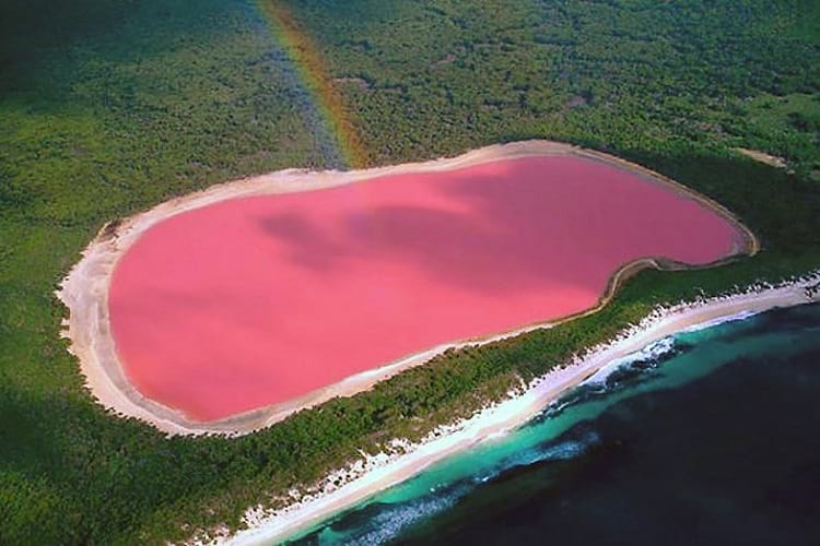
Lake Hillier, Australia. (Kurioziteti123 / Wikimedia Commons)
Oceans, rivers, and lakes, as a rule, contain salt amongst other minerals with oceans having the highest content of salt since they contain waters from rivers and lakes combined. Rainwater renews the water in rivers; hence the salt is most diluted in them. Lakes, on the other hand, can be both freshwater and salty. When a lake contains an excessive amount of salt, it starts to produce a type of algae that has a reddish-pink hue to it. The lakes with this type of algae are colloquially known as pink lakes due to their colour.
Saline lakes generally have a higher concentration of salt and chemicals than most lakes. Lakes become saline when there isn’t enough water flowing into them or the water flowing into it is unable to drain into the sea, the remaining water then goes through the natural evaporation cycle thus increasing the concentration of salt. When lakes reach saturation or near saturation point of salt, they are termed as brine lakes. Brine lakes have extremely high salt concentrations of 40%, which is even higher than the ocean. They exist due to very high evaporation rates in dry climates. Saline and brine lakes have a very unique flora and fauna that can only survive in such high salt concentrations.
Pink lakes in Australia
In Australia, there are 3 pink lakes existing due to this condition. Hutt Lagoon lies north of the Hutt River in Western Australia. There are tourism road trips that take you from Port Gregory to Kalbarri, on which you can view the Hutt Lagoon. It can also be seen from flights. It is an excellent place for salt production. The salt and gypsum produced here have received commendable recognition.

Hutt Lagoon. (Dan Nevill / Flickr)
Spencer Lake lies in the Goldfields-Esperance region of Western Australia. It had not been pink for a decade until 2017, and it is speculated the reason for this was due to the construction of a railway and a highway. Lake Hillier also lies in the Goldfields-Esperance region and is often confused with Spencer Lake. It is noted that the lake appears a bright bubble-gum pink from flights, but up close near the shoreline it only has a light pink hue.

Bird’s eye view of lake Hillier. (Aussie Oc / Wikimedia Commons)
Pink lake in Senegal
In Senegal, Africa, the Lake Retba also exist under similar conditions of high salinity and a pink hue. Although, due to seasonal variation, the pink hue is majorly visible during the summer season and not as much during the monsoons. The flora and fauna here are different than in the Australian lakes, however; the fish here have evolved to live in saline waters but are much smaller than average due to dwarfism.

Lake Retba. (Antonin Rémond / Flickr)
Other pink lakes around the world
Apart from these, there are other pink lakes that exist due to similar conditions. There’s another one in Australia called Quairading Pink Lake and a Field of Lakes which has multiple pools of pink water with varying shades of pink. There is also the Salina de Torrevieja in Spain and the Masazirgol in Azerbaijan. Although, the Dusty Rose lake in Canada is pink not because of high salinity but because of the rock flour that pours into the lake from surrounding glaciers.

Salina de Torrevieja, Spain. (Alberto Casanova / Flickr)
The speciality of Lake Retba in Senegal
Considered a high-ranking contender in the list of UNESCO World Heritage Site since 2005, the pink-coloured Lac Rose or Lake Retba in Senegal is a bit different from most of the other pink lakes in the world. Its high salt content makes it almost impossible for living creatures to drown in it, thus making it a lot like the infamous Dead Sea of Jordan. People can float in it but there are a host of activities that a tourist needs to undertake just to have a dip in the pink lake.
The Senegalese lake is also known for its salt collection activity, which in itself is an interesting task. Fishermen, armed with spades, make use of narrow canoes to bring back huge chunks of salt from under the water body. They position themselves in the middle of the lake and start digging for salt, which they then collect in large baskets and bring them back to their boats. The women folk then wade through the shallow waters to collect these chunks from the canoes to bring them ashore. Here the salt is later treated with iodine and processed further before it is sent out into the West African markets.

A worker harvesting salt from Lake Retba. (Anthea Spivey / Wikimedia Commons)
One thing that sets the salt collecting activity in Lake Retba apart from the regular ones is the use of shea butter. Fishermen and women both apply shea butter on their exposed skin parts to protect themselves from the dangerous effects of the high salt content. In the absence of shea butter, the salt in the lake has the potential to cut open the skin or make wounds to the exposed areas.

Thieboudienne. (T.K. Naliaka / Wikimedia Commons)
But if there is one thing that people really love about Lake Retba, it is a traditional delicacy prepared from local fish. Called thieboudienne, it is a dish prepared with a mix of rice, tomato sauce and fish, which Senegalese fishermen preserve using salt, obtained especially from Lake Retba. The stew is a very popular dish in the country and Lake Retba provides for the continuous supply of salt for the particular food item.
The science behind the colour
The science behind the pink coloured lakes is actually quite complex. The salt content of the lakes has to be higher than that of the sea, and the temperature has to be high enough, and perfect light conditions have to be met. The high content of salt in the lakes makes it a breeding ground for a beta-carotene producing algae, also scientifically called Dunaliella Salina, that thrives in salty environments.
Beta-carotene is the same chemical that is found in carrots, and that gives it its orange colour The chemical is actually a reddish-pink colour, but the combination of it being mixed with water and the right light conditions give the lakes a pink hue. Carrots only contain 0.3% of beta-carotene, whereas these algae contain up to 14% of it. This chemical also coats the chlorophyll that is found in the algae, thus protecting it from the extreme heat conditions in these arid regions.
The environmental conditions are so vital to the colour of the lake that any external changes can affect it. One such example is Spencer Lake; since the construction of the Southcoast highway, the lake lost its connections with Lake Warden which supplied the lake with salty water. Once the connection was lost, the algae began to perish, thus making the lake lose its pink hue.

Salt ponds at South Bay, San Francisco. (Doc Searls / Flickr)
Importance of salt lakes
Salt lakes prove to be an excellent place for salt production and help manufacture table salt which is an important constituent of our diets. Even the climate that is created by the evaporation cycle around these lakes is supposed to be one of the healthiest. In fact, the microclimate that surrounds the lake in Spain is considered to be the healthiest in all of Europe by the World Health Organization (WHO). Many of these lakes are also rich in minerals with healing properties for skin and lung disease patients. These salt lakes are also heavily laden with brine shrimp, which are used by fish farmers as feed for the fish and in the aquarium fish market.
Most importantly, these lakes also help bring in tourism trade due to their uniqueness. The elaborate conditions for the lake’s existence are not easy to replicate elsewhere, and hence draw tourists from all over the world. There are special road trip tours as well as flight tours that help you see these mythical-looking natural wonders.
Enjoyed this article? Also, check out “The Lonar Lake: An Astronomical Marvel“.
Recommended Visit:
1. Lake Hillier | Western Australia
2. Lake Retba | Senegal, West Africa
3. Salina de Torrevieja | Spain
4. Masazirgol | Azerbaijan
Fact Analysis:
STSTW Media strives to deliver accurate information through careful research. However, things can go wrong. If you find the above article inaccurate or biased, please let us know at [email protected].
RELATED
- March 2, 2019 Wave Rock: Where a Massive Prehistoric Wave, Just About to Break, is Etched Permanently in Stone
- January 5, 2020 Australian Bushfires: Deadly Yet an Inextricable Part of the Australian Ecosystem
- February 21, 2019 Lake Baikal: The World’s Deepest Lake That Holds 22-23% of the World’s Freshwater
- April 20, 2019 Forest Fire: Birds Deliberately Setting Forests on Fire to Flush Out Prey
The post Pink Lakes: Where Rose-Tinted Lakes Surrounded By Lush Greenery Are Truly a Sight to Behold appeared first on .
]]>The post Proboscis Monkey: The Rare Borneo Monkey Species with an Unusually Long Nose to Lure Its Females appeared first on .
]]>
Proboscis monkey. (Charles J Sharp / Wikimedia Commons)
Nature has gifted all animals with a distinct trait that distinguishes them from the rest of the animals in the world. But there is something very different about the proboscis monkey that sets it apart from all the simians. A long, pendulous nose that hangs down till its mouth, giving it an unattractive appearance at the first sight itself is what the monkeys are mostly known for. Endemic to the jungles of Borneo, an island in Southeast Asia, shared by Malaysia, Indonesia and Brunei, these proboscis monkeys are found in large groups along the banks of rivers or living on trees.
Characteristics of the Proboscis Monkey
Commonly known as the Proboscis monkey, its scientific name is Nasalis larvatus, which belongs to the class of mammals. They are named after their peculiar nose, which as per the animal experts, are used as organs to attract mates. The Indonesians call the Proboscis monkey the ‘Dutchman’ since they believe that the early Dutch colonizers had large, pot bellies and unusually long noses similar to these primates. All adult proboscis monkeys are generally brown in colour, with reddish-brown fur on their heads and shoulders. Their arms, legs and long tails are usually grey in colour unlike their entire coat of brown. The female gives birth to a single infant at any time of the year and her gestation period lasts for only six months. The babies are mostly born with bluish faces, which change as they start to mature.

A male proboscis monkey. (pen_ash / Pixabay)
The proboscis monkeys are omnivores; they can stand tall between 24 and 28 inches in height on an average and can weigh anywhere between 22 to 25 kilograms. The females weigh half of what the males weigh and are smaller in size as compared to the male primates. Only the male proboscis monkeys have these long, fleshy noses, while females and infants do not possess any such unique feature. Also, the one characteristic that tells them apart is their ability to swim. The proboscis monkeys have a lifespan of roughly twenty years on an average.

A female proboscis monkey with her child. (Max Pixel)
The proboscis monkey is an arboreal species like its other cousin primates and dwells on trees, and sometimes gets on land in search of food. It lives mostly on trees, near coastal areas like swamps, marshes and mangroves. Its greatest predator is the crocodile that lurks deep in the river waters beneath, attacking the monkey, once it gets in the water. Jaguars and leopards also prey on these monkeys for food. The proboscis monkeys live in harems, which are large groups of females, where a single dominating male takes on more than a dozen females, along with their offspring. Mature, young male monkeys live in separate groups and are usually led by an older male.
Diet of the Proboscis Monkey
The proboscis monkey is an omnivore and can eat anything that it can lay its hands on. But most commonly, the primate’s diet consists of seeds, leaves, fruits and occasionally insects. The monkey eats only unripe fruits and regurgitates its food from the stomach like ruminant animals, to swallow it again for a second digestion. It is the only surviving monkey species in the wild that eats its food twice. It shares a symbiotic relationship with special bacteria in its tummy, which help it re-digest its food in the complex, cow-like chambered stomach.

A male Proboscis monkey eating. (Agoes Suwondo / Wikimedia Commons)
Swimming ability of the proboscis monkey
The proboscis monkey is an agile swimmer, quite unlike its other counterparts and has evolved over the years, possessing partially-webbed feet, a lot like ducks, for a faster swim. This helps it escape its predators in the rivers. The webbed toes help the monkey to swim for a longer period of time and cover longer distances. The monkeys wade across the rivers in an upright position and are bipedal in nature.
The unusual noes of proboscis monkey
As per joint studies in Kyoto University, Cardiff University and Sabah Wildlife Department in Malaysia, biologists say that the elongated noses of the proboscis male monkeys are ornamental tools to attract a female. The odd-shaped noses that hang down their mouths also serve as attractive features, which a female monkey takes very seriously and for which, she can even change her group. The enlarged nose is also used as a horn to threaten other dominant males, who try to lure away their potential mates. Scientists believe that the proboscis monkeys use their peculiar noses to honk and roar so as to intimidate other males, while their nasal cavity also helps in amplifying their mating calls, which largely impress females.
Habitat and endangered status
Although the proboscis monkey species are protected under the Sabah Wildlife Department, they are endangered and their population is fast declining. Their habitats are slowly depleting. The extensive clearing of vegetation in the rain forests of Borneo for logging, unchecked human settlements, poaching and illegal trade of these unique monkey species and other such activities have pushed the monkeys to the brink. Even natives in the forests that hunt the proboscis monkey for its flesh, which they consider an exceptional delicacy, has put the monkey population in jeopardy. Declining by almost fifty per cent in the last forty years, these monkeys are also used in medicinal preparations in China, which has put them at a greater risk.
The palm-oil planters that are mostly active near the riverbanks and mangroves are posing the greatest threats to the unique Borneo monkey. The palm plantations are eating into the proboscis monkey habitat, which has brought down their population very sharply. The IUCN Red List has declared the proboscis monkey an endangered species and conservations have now come up with plans to save their populations.
Although the rare proboscis monkey has achieved an iconic status in the world and is quite popular among tourists like the orangutan from the same region, its survival is at risk. But there’s still hope for the primates, which not only give a strange feeling at their first sight but also make us marvel at the hidden gems nature has in store for all of us.
Enjoyed this article? Also, check out “The Silky Anteater: The Nocturnal Dweller of the Tropical Rainforests“.
Fact Analysis:
STSTW Media strives to deliver accurate information through careful research. However, things can go wrong. If you find the above article inaccurate or biased, please let us know at [email protected].
RELATED
- December 1, 2018 Mapogo Lions: The Six Legendary Lions That Meant ‘Bloody’ Business in Their Quest for Dominance
- March 6, 2019 The Silky Anteater: The Nocturnal Dweller of the Tropical Rainforests
- December 25, 2018 Jack the Baboon Once Served as a Railway Employee for 9 Years and Didn’t Commit a Single Mistake
 November 15, 2018 Rat King: The Horrendous Wheel of Animal Suffering
The post Proboscis Monkey: The Rare Borneo Monkey Species with an Unusually Long Nose to Lure Its Females appeared first on .
]]>The post Mapogo Lions: The Six Legendary Lions That Meant ‘Bloody’ Business in Their Quest for Dominance appeared first on .
]]>
Mapogo lions looking at a herd of buffalo, circa 2011. (Mike’s Birds / Flickr)
A lion is not called the King of the Jungle for nothing. These large animals belonging to the cat family are not just exotic, magnificent beasts but also one of the most formidable hunters of the wild. Living in groups called prides, there was once a legendary union of six male lions that invoked terror in the lands during their prime. The Mapogo Lions of Sabi Sand Reserve in South Africa was a terrorizing group that kept other lions in the region away from their territory. And to keep competition off, these animals killed as many as hundred lions to stay on the top.
The early story of the Mapogo Lions
Born over a period of time in the Sparta Pride in Sabi Sand Reserve, adjacent to the Kruger National Park, five young lions had a playful youth like their other counterparts. As per written records, these lions came into their own in March of 2006, when their reign of terror had just begun. Animal observers named these Mapogo lions after their distinct characteristics. Kinky Tail was named so because he had a tightly curled tail. Satan or Mr. T, the violent of the lot, had a mane groomed in a natural Mohawk style. Pretty Boy was named so because he was obviously more pretty-looking than his brothers. Rasta and Dreadlocks were named after their specifically-styled abundant manes. After the pride lost a young male cub, Makulu (meaning big in Zulu) – a four-year-old – joined in without resistance from the others.
It is said that this band of six brothers stayed close to their pride as cubs, but when they reached their youth, they were abolished so that they could begin a life of their own. But the fact that surprised many biologists was that these young lions did not leave each other’s company at all, rather they hunted together, lived together and reigned terror during their prime.
The Mapogo Lions’ terror-inducing times
After the six lions formed a coalition, they began hunting to feed themselves. A wild buffalo was their first kill and they slowly graduated to killing giraffes, which is supposedly not an easy catch even for the mighty lions. But what set this coalition of brothers apart was their cannibalism, which baffled researchers and animal behaviourists. In their quest for dominance, they did not leave behind any living lion, lioness or cub, who could possibly take over their supremacy. Divided into two groups, these Mapogo Lions dominated the northern and southern territories of the Sabi Sands, keeping away competition from their fellow lions. Rasta, Dreadlocks, Makulu and Pretty Boy formed one band, guarding the southern sides, while Mr. T and Kinky Tail, the inseparable duo, watched out for the north.
The beginning of cannibalistic behaviour
During their reign, not a single lion from other prides could enter their territory and if any beast tried to intrude, it was killed instantaneously. Labelled as sadistic and ruthless, these six coldblooded lions were a formidable force that wiped out entire prides only to stamp their supremacy in the region. What came across as unnatural behaviour was when field guides and rangers saw that these lions killed their own cubs to eliminate future competition. But that was not the end of their brutal behaviour. These lions fed on the flesh of their dead cubs too! And that was just the beginning of their vicious activities.
Once a young male lion from Manjigilane pride tried to show his dominance, but Mr. T and Kinky Tail, in an act of defiance, tore apart the young lion, shattering his pelvic bones and then ate away the soft flesh of its underbelly. Wounded and tired the two dreadful brothers continued their cannibalistic behaviour and same was the case with the other four lions that guarded the southern territory. In just a year, these six brutal brothers took down a hundred others of their own kin, including females and young ones to prove their power in the land.
End of an era
It was in the year 2010 when a new pride of Manjigilane lions had tried to take control of the Sabi Sands, when the death of Kinky Tail was recorded for the world to witness. In a battle that lasted for hours, Kinky Tail was taken down in the same way; he and his ferocious brother Mr. T hunted all their lives. The young lions tore Kinky Tail’s body apart and left him to die, leaving Mr. T almost orphaned. The lone lion then moved towards the south to be with his four other brothers, who by now, had prides of their own.
In the next few months, these five lions managed to keep off competition, mate and take over new prides, but their reign had eventually started to come to an end. Rasta was the first to be killed in July 2010 by a young Manjigilane coalition in an intense fight. Dreadlocks went missing in the same year after he did not return from a night stroll. Some believe that poachers could have killed him or he was taken down by another coalition of lions. Mr. T was killed by the Selati pride in March 2012 in the same way as Kinky Tail was killed by a group of young males – ambushed and subdued. Makulu died during a confrontation with males of the Kruger pride in January 2013. Nobody knows for sure what happened to Pretty Boy or how he died, but rangers speculate that when he was last sighted, he looked thin and weak and could have died of starvation.
Ruling with an iron paw between the years 2006 and 2012, this extremely rare coalition of six cannibalistic lions, reigned terror and wiped out prides that posed a threat to them. Despite the area ruled by eight other prides during their time, none stood a chance at dominance for they were dealing with an aggressive and brutal lot of lions that was never seen before in the wild, killing and eating their own kith and kin. This band of five brothers and one half-brother has an entire documentary filmed on them titled ‘Brothers in Blood: The Lions of Sabi Sand Mapogo’, which proves how these legendary majestic beasts once ruled the wild.
Enjoyed this article? Also, check out “Tsavo Man-Eaters: A Pair of Rogue Lions That Killed Nearly 135 People“.
Fact Analysis:
STSTW Media strives to deliver accurate information through careful research. However, things can go wrong. If you find the above article inaccurate or biased, please let us know at [email protected].
RELATED
- December 25, 2018 Jack the Baboon Once Served as a Railway Employee for 9 Years and Didn’t Commit a Single Mistake
- March 6, 2019 The Silky Anteater: The Nocturnal Dweller of the Tropical Rainforests
- January 8, 2019 Proboscis Monkey: The Rare Borneo Monkey Species with an Unusually Long Nose to Lure Its Females
- November 15, 2018 Rat King: The Horrendous Wheel of Animal Suffering
The post Mapogo Lions: The Six Legendary Lions That Meant ‘Bloody’ Business in Their Quest for Dominance appeared first on .
]]>The post Penitentes – The Remarkable Ice Pillars of the Atacama Desert appeared first on .
]]>
Penitentes at Atacama desert. (ESO/B. Tafreshi / twanight.org)
High in the Andes, in the Atacama Desert, an astonishing sight greets visitors. In certain areas, entire fields of ice and snow pillars stretch up towards the sun. Some of the pillars are small, measuring only about a few centimetres, but others can tower up to 20 or 30 feet. The pillars occur in a very close together spaced formations, making it difficult and sometimes even impossible to pass through their midst, and they are broad at the base and narrow progressively to form elongated, conical points at the top. Seen together, they look remarkably like a crowd of white-garbed, hooded priests bent in prayers, and it is this resemblance that gave them their name.

Procession of Penance in Malaga, Spain. (Pedro J Pacheco / Wikimedia Commons)
Penitente is the Spanish word for a remorseful person, and during the Holy Week in Spain, there is a Procession of Penance in which priests with pointed white hoods participate to perform religious penances.
Penitentes of the Atacama Desert
A cold, dry wind blows through the arid Atacama Desert that stretches across part of Chile’s northern region and Peru’s southern region. According to local belief, it is this wind that gives rise to the ice and snow pillars that we know as penitentes.
In the Chajnantor plain in the Atacama, which is 4000 feet above sea-level, the penitentes occur year-round in open areas that get plenty of sustained sunlight. You would think that the ice and snow would melt into puddles under the hot sun, but instead of melting, the snow transforms into vapour. This process of ice and snow turning directly into water vapour is known as sublimation. As the water-vapour moves in the upward direction towards the sun, it causes shifts and changes in the ice and snow and that leads to the formation of the pointy penitents.

Penitentes in the Chajnantor Plateau. (Penitentes in the Chajnantor Plateau / Flickr)
Charles Darwin and the Penitentes
On 22 March 1835, Charles Darwin, the famous British biologist, was on his way to Mendoza city in Argentina from Santiago de Chile, and he happened to make his way through the Piuquenes Pass in the Andes mountains. He described the region as having “bold conical hills of red granite” and “several broad fields of perpetual snow”. It was here that he first encountered an entire field of tall penitentes and while he marvelled at this fascinating phenomenon, they turned out to be quite a nuisance nevertheless. Close-set as they were, they formed a formidable barricade and his cargo mules, he wrote, had a difficult time picking their way through them. Darwin also noticed a dead, frozen horse sticking up high in the air, impaled on the penitentes, with its hind legs pointed to the sky. In his notes, Darwin surmised that the horse had probably fallen head first into a hole and, later, as the penitentes formed and grew taller and ever taller, the dead animal was pushed out to the surface and thence skyward.
Darwin was the first Western scientist to write about the penitentes, and his observations sparked a great deal of interest in these natural ice sculptures and led other researchers to try and discover how they were formed.

Penitentes can be ranging from a few centimetres tall up to 10 meters. (Daniel P. Gauer / Flickr)
Theories about the formation of Penitentes
For quite a while, researchers subscribed to the view shared by Darwin and the local people that it was the Andean wind that caused the penitentes to take shape. Many researchers have since challenged this view and have attempted to find other explanations, backed by experimental recreations of penitentes in the laboratory.
Meredith Betterton and the water-vapour sublimation process
A biophysicist at the University of Colorado, Meredith Betterton was sufficiently intrigued with penitents to recreate them in the laboratory and formulate a predictive mathematical model to explain their formation process.
According to Betterton, sublimation was the main cause of penitente formation. Sublimation, as mentioned before, is the process of ice or snow turning directly into water vapour without melting into water first. When the sun shines down on the ice or snow, its heat causes some areas to turn into vapour faster than the others and this creates shallow troughs or depressions in the formerly smooth surface. Under sustained sunlight, the heat and any melted water cut more into the troughs and deepen them further, while the walls remain relatively unaffected. What you get as a result are tall spikes of ice or snow, and as the process keeps repeating, an entire icy forest of penitents can spring up.

Penitentes. (ESO)
Philippe Claudin and the water-vapour diffusion process
The scientific community accepted Betterton’s explanation for the formation of penitentes, but a group of French researchers from the Institute of Industrial Physics and Chemistry in Paris wasn’t entirely satisfied with it. This group, which included researcher Philippe Claudin, pointed out that Betterton’s model was incomplete since it failed to explain why there was the fixed spacing between the penitentes. If the penitentes were indeed formed by ice vaporizing at different speeds, there shouldn’t have been such equal spacing. There ought to have been more diversity in the spacing values.
In the course of their work, the French researchers discovered that penitentes weren’t formed only due to sublimation after all, but from a combination of water vapour diffusion and heat transport. They found that when sunlight penetrates the snow or ice, the sunlight is absorbed and trapped inside the snow or ice and this makes the inside warmer than the outside. The inner trapped heat increases the process of sublimation occurring on the upper layer of the ice or snow. The speed of the sublimation process depends on the thickness and steepness of the ice or snow and also on how fast the formed water vapour disperses away from the ice or snow surface. If the ice or snow is thin and not steeply inclined and the water vapour moves away faster, sublimation will be faster. If the ice or snow is thick and steeply inclined and the water vapour remains saturated at the surface, sublimation will be slower.
The troughs formed in the ice or snow do not have steep inclines and have relatively thin surfaces and the water vapour diffuses from them more quickly, so sublimation occurs fast and the troughs deepen. The rate of water vapour diffusion in the troughs also determines the spacing between the penitentes. The faster the diffusion, the faster the sublimation, and the wider the spaces. On the other hand, the steep and thick surfaces of the penitente spikes and the higher saturation of water vapour in the air around them slows down the sublimation process; if the surrounding air has a high content of water vapour, more water vapour cannot escape from the ice or snow.
Vance Bergson and Penitentes in the lab
French researcher Vance Bergson and his colleagues at Paris’s Ecole Normale Supérieure recreated penitentes in their laboratory with a block of ice in a freezer. Along with controlling the temperature and humidity in the freezer, they kept a light shining continuously on the ice block. Within a few hours, they observed formations of small penitentes on the ice block. In this experiment, their findings turned out to be different from those of Claudin and his group of researchers. According to Bergson and his team, the humidity in the freezer did not appear to affect the growth outcome of the penitentes very much, at least not until the humidity level in the freezer reached 70%. The penitente growth, however, did slow down when the researchers increased the freezer temperature to above -4 degrees Celsius. This indicates that a rise in overall global temperatures is not likely to be good news for the continued existence of penitentes.
If permanent penitente formations disappear, it is likely that glaciers are going to experience an adverse effect of their absence. Tall penitente icy forests cast shadows on the plain surfaces of glaziers and slow down the natural sublimation processes and keep the glaciers from melting away. Bergson and his team discovered that adding a layer of black carbon powder over snow or ice can help shade the surface from light and inhibits sublimation and speeds up the growth of penitentes.

Penitentes like formation on an iceberg. (Pxhere)
Guilleminot and Olea and the dew point theory
According to Pablo Guilleminot and Rodrigo Olea of the Universidad Andrés Bello, the formation of penitentes is a “purely radiation-driven phenomenon”. The sunlight enters the ice or snow surface at a certain angle and this influences the growth of the penitentes and causes the distinctive tilt towards the sun. For penitentes to form, the ice or snow must have a below freezing point dew point. Which means the surface ice loss rate by the sublimation process must be greater than the rate at which the surface absorbs vapour from the surroundings. If instead of undergoing sublimation, the ice melted into water, the water would smooth away irregularities and prevent the formation of penitentes.
What all the researchers appear to agree on is that more research is necessary to get a better understanding of penitentes and glaciers.
Penitentes on Europa and Pluto
Penitentes occur mainly in the Andes and in the Himalayas on earth, but they may also occur on other planets and planetary moons. Recent NASA findings point to their occurrence on Pluto and on Europa.
The science-fiction writer, Arthur J. Clarke, was way ahead of NASA when he wrote in his 1982 novel “2010: Odyssey Two” – “All these worlds are yours – except Europa. Attempt no landings there.”
Because landing on Europa would be a dangerous enterprise, and, apparently, this is indeed the case.
Europa is one of planet Jupiter’s four moons and is apparently an ice-covered world with an extensive salt-water sea underneath the ice. The Arecibo Observatory in Puerto Rico sent radar signals to map Europa and the data they collected pointed towards an uneven landscape of deep ridges and crevices. When NASA sent their New Horizons spacecraft to Europa in 2015, they discovered what they call a ‘bladed terrain’. According to computer simulations created by NASA scientists, the icy equator, which receives the strongest sunlight on Europa and has temperatures as low as -200 degrees Celsius, is studded with jagged spires of penitentes that occur at intervals of 7.5 metres and are much bigger and taller than the penitentes on earth. Europa’s penitentes may very well scale heights of 50 feet. That is almost as tall as some five storey buildings. Imagine an entire icy forest of such tall penitentes.
Not at all the sort of surface that anyone with a sound mind will want to attempt a landing on, given the impossibility of finding space for setting down a spacecraft. NASA is sending a Europa Clipper mission to Europa in 2022-2025 and that will likely provide more details of the moon and its penitentes.
Enjoyed this article? Also, check out “Salar de Uyuni: The Incredible Salt Flats of Bolivia“.
Recommended Visit:
Chajnantor Plateau | Atacama Desert, Chile
Fact Analysis:
STSTW Media strives to deliver accurate information through careful research. However, things can go wrong. If you find the above article inaccurate or biased, please let us know at [email protected].
RELATED
 April 23, 2020 Changing the Skull’s Shape to Adhere to the Community’s Beauty Standards
  October 22, 2018 Salar de Uyuni: The Incredible Salt Flats of Bolivia
- November 20, 2019 Solifugae: Unique Creatures That Are Neither True Scorpions Nor True Spiders
- August 20, 2018 Noctilucent Clouds: Shining in the Summer Twilight Sky
The post Penitentes – The Remarkable Ice Pillars of the Atacama Desert appeared first on .
]]>The post Thylacine: Meet the Extinct Tasmanian Tiger appeared first on .
]]>
A pair of Thylacine in National Zoological Park, Washington, D.C. (Baker; E.J. Keller / Smithsonian Institution)
The thylacine was a queer-looking wolf-like animal with stripes on the back like a tiger. It is said to be the largest carnivorous animal that was marsupial to have ever existed.
A marsupial is a species of mammals with a pouch, known as a marsupium, in which the newborn stays till old enough to leave. This extraordinary species has been presumed extinct after the last known of its kind died in a zoo in 1936.
Getting to know the thylacine
Though the thylacine was as slender as a fox, and the size of a wolf, its skull was shaped like a dog. Due to its origin in the Australian state of Tasmania, it was often referred to as the Tasmanian wolf or Tasmanian tiger.
Thylacines were known to be ambush hunters, attacking their prey with the agility of cats. A nocturnal animal by nature, it restricted to hunting small birds, animals like quokka and other wallabies.
A typical thylacine was approximately 100 to 130 cm long, with an average weight of 25 to 30 kg. It sported yellowish brown fur with dark stripes on the back. It’s tail was 20 to 25 cms long, and rather stiff, pointed away from the body like a kangaroo’s.
The jaws had an impressive colossal gape of nearly 90 degrees. Being marsupial, the female of the species had a pouch on the belly with the opening towards the rear, in between the hind legs. Partially developed, the young thylacines had well-built muscles in their forearms to climb into the marsupium.

1909: Mother thylacine with her three cubs. (Wikimedia Commons)
The female sometimes carried up to 4 young thylacines in her pouch and the young suckled within till they became old enough.
The first appearance and extinction
The fossils of the oldest thylacine, the Nimbacinus dicksoni or Dickson’s thylacine, suggest its existence all the way back to 23 million years ago. This was a much smaller species than the modern thylacine. Incidentally, the modern thylacine is said to have appeared approximately 4 million years ago.
The Tasmanian tiger, though extinct for many years in most parts of Australia, seemed to have survived well into the early 20th century in Tasmania. During the era of the European settlements in Tasmania in the 17th century, they were held responsible for the predation of sheep and other farm animals.
The Van Diemen’s Land Company started by British merchants, put a bounty on the thylacine in 1830. By 1888, the government of Tasmania, convinced of the killings, were offering £1 for killing an adult thylacine and 10 shillings for a pup.

1930: The last wild thylacine hunted by a farmer. (Wikimedia Commons)
By late 1920s, the Tasmanian tiger was rarely spotted in the region. Probably the result of killings by bounty hunters, and farmers themselves in order to protect their animals.
Though the popular belief was that the thylacine was responsible for the killings of farm animals, the ‘Tasmanian Advisory Committee for Native Fauna‘ started zeroing on natural reserves as a suitable habitat for protecting the already endangered species.
Apparently, the last thylacine that was killed, was in 1930. Rumoured to have been a male, it was shot by a farmer, Wilf Batty in the small town of Mawbanna in Tasmania.
The absolute last thylacine was considered to be one which had been trapped in the Florentine Valley by a timber cutter named Elias Churchill in 1933. Elias sent it to the Beaumaris Zoo in Hobart, Tasmania. Unfortunately ‘Benjamin‘, as the Tasmanian tiger came to be known as, died on September 7, 1936.
Benjamin’s death was also the end of the last known thylacine. The thylacine was eventually proclaimed to be extinct in 1982 by the International Union for Conservation of Nature and subsequently in 1986 by the Tasmanian government). The fact that Benjamin was a male could only be determined in 2011 after a detailed study of a small motion film footage taken by Zoologist David Fleay in 1933 was done. The day of death of the last thylacine is observed as the “National Threatened Species Day” in Australia since 1996.
Thylacine sightings: A glimmer of hope?
There have been several alleged sightings of the Tasmanian tiger since its extinction in 1936. In 1973, a South Australian couple Liz and Gary Doyle claimed to have captured a 10 second footage of the marsupial on camera. However, it could not be established that the footage was of a thylacine because of the poor quality of the film.

Numbat, native to South Australia is the closest living relative of the thylacine. (Martybugs / Wikimedia Commons)
Later in 1982, wildlife biologist Hans Naarding came face to face with the animal which darted away before Hans could take a picture. Kevin Cameron who worked with the Agricultural Protection Board, took 5 photographs of the thylacine in the wild. He spotted the animal in 1985, intently digging behind a tree stump with only the rear portion of the body visible.
Distinguished Research Professor at James Cook University in Australia, William F. Laurance, kick-started a search for the elusive animal in 2017. The same year, a trio who call themselves the Booth Richardson Tiger Team (BRTT) claimed to have video footage of the Tassie tiger. The recordings were not conclusive when assessed by wildlife experts.
Whether it is really extinct or not, is a mystery yet to be solved. One thing that can be concluded for sure, is the fact that the Australians are determined to find their beloved Tasmanian tiger if it still exists, one way or another.
Enjoyed this article? Also, check out “Maned Wolf: The Existential Crisis of Chrysocyon – the Golden Dog That Looks Like a Fox“.
Fact Analysis:
STSTW Media strives to deliver accurate information through careful research. However, things can go wrong. If you find the above article inaccurate or biased, please let us know at [email protected].
RELATED
- September 16, 2019 Maned Wolf: The Existential Crisis of Chrysocyon – the Golden Dog That Looks Like a Fox
- December 1, 2018 Mapogo Lions: The Six Legendary Lions That Meant ‘Bloody’ Business in Their Quest for Dominance
- October 11, 2019 Champawat Tiger: The Killer of 436 Humans is a Case of Animal-Need Pitted against Human-Greed
 June 28, 2019 Rain of Animals: A Rare Scientific Phenomenon Where Animals Seem to Fall from the Sky Inexplicably
The post Thylacine: Meet the Extinct Tasmanian Tiger appeared first on .
]]>The post Salar de Uyuni: The Incredible Salt Flats of Bolivia appeared first on .
]]>
Piles of salt at Salar de Uyuni. (Luca Galuzzi / www.galuzzi.it)
The Salar de Uyuni is one of the peculiar marvels of the natural world. It is the largest salt flats in the world, extending across an area of 10,582 square kilometres and situated at an altitude of 3,656 meters, in southwestern Bolivia’s Potosi and Oruro departments. Surrounded by the snow-covered Andes mountains, it is a remote region with a remarkably scenic landscape. There is little to do in the Salar de Uyuni, but there is plenty to see and experience.
Salar de Uyuni
The Spanish name translates to ‘the salt pans of Uyuni’. The salt flats get their name from the sparsely populated Uyuni town, located some 25 kilometres from them.

Truck collecting salt for processing. (Ricampelo / Wikimedia Commons)
Salt is the main feature of the Salar de Uyuni. There is an estimated 11 billion tons of it and, as the bright sunlight ensures a continuous production, the region is not likely to run out of it any time soon. The salt-processing factory in Colchani, a small village 20 kilometres from Uyuni, refines over 25000 tons of salt annually and exports it all over Bolivia and to Brazil.
Aside from salt, the Salar de Uyuni has rich lithium deposits. They account for almost 70% of the world’s lithium deposits and could mean a huge fortune for Bolivia, but the prospect isn’t exciting everybody. There is a raging controversy in the region about how extracting lithium in great amounts could negatively impact the salt pans and the environment.
Formation of Salar de Uyuni salt flats
The white, salty plains of Salar de Uyuni came into existence after the gigantic Lake Minchin dried up and disappeared over 40,000 years ago. Several smaller prehistoric lakes replaced it and evaporated as well, leaving behind salty strata.
That is the scientific explanation. The mythologists have a different take. There are two dominant myths about how the Salar de Uyuni formed, and both involve women.
In the first story, the salt flats resulted from a domestic saga. A man named Cuzco cheated on his wife, Thunupa, and left her for a younger woman, Cosuna. The wife wept tears of grief and her salty tears flooded the ground and created the salt pans.
The second story involves a woman and her two lovers. When she became pregnant, her two lovers fought with each other over whose child it was. The distressed woman sent her child away and tried to stop the fighting. But then she realized she had to feed her child and she released her breast milk in that direction. The milk flooded the plains, and these later became the salt flats.

View of Salar de Uyuni from space. (NASA)
In any case, the salt flats are so extensive that they are apparently visible from space and NASA uses them for satellite position. NASA also conducts experiments for their Mars missions on the nearby Lincancabur volcano. The atmosphere here, according to NASA, is like what Mars might have had many billions of years ago.
Natural features of the Salar de Uyuni
Apart from the salt strata, the most remarkable aspect of the Salar de Uyuni is its flatness. It is not completely flat as once thought – there are minor undulations – but flat enough to lend itself to some amazing trick photography opportunities and tourists make the most of it.
During the rainy season, from December to April, rainwater floods the salt pans and transforms them into a gigantic mirror reflecting the surroundings and the sky. It is an incredible spectacle and another attraction factor for tourists. To avoid getting mired in the resulting mud though, visitors can safely access only certain areas of the salt flats during this period. In the dry season, from May to November, people can trek across the entirety of the flats.

The salt flats during the rainy season. (Ezequiel Cabrera / Wikimedia Commons)
There are four lakes in the area – Laguna Blanca, Laguna Verde, Laguna Colorada, and Laguna Hedionda. Located at the foot of the Licancabur volcano and situated adjacent to one another, Laguna Blanca and Laguna Verde have waters that are, respectively, white and turquoise from the mineral particles in them. Laguna Colorada appears red from the minerals and algae present in its waters, and the flamingos that flock here get their feathers dyed pink in colour from eating the red algae. In contrast, the flamingos in Laguna Hedionda are white because the algae are not present in that lake. There are, incidentally, three species of flamingos in the region, including the endangered James’ Flamingo. There are also many other bird species, local as well as migratory.

Andean Flamingos at Laguna Colorada. (Luca Galuzzi / Wikimedia Commons)
Visitors can see natural geysers and bubbling hot mud stretches in the Sol de Mañana geothermal area and immerse themselves in outdoor hot-water pools at the Polques Hot Springs. It can be quite an experience to sit in hot water on a chilly evening and look up at clear night sky lit with a million stars. Since there is no pollution here, the night skies are very vivid and beautiful.

Polques hot springs. (© Florent Mechain / TravelMag.com)
Hundred-year-old cacti and other plants grow on Isla Incahuasi and Isla del Pescado, two islands in the middle of the Salar de Uyuni. In the olden days, when travelling across the salt flats, people made journey breaks on these islands. These islands and the areas around the lakes are the only places with plant life in the Salar de Uyuni.

Isla del Pescado. (Pavel Špindler / Panoramio)
Other sights near the Salar de Uyuni
In the 19th century, there was an ambitious plan to build a railway network connecting Uyuni to other parts of South America. The plan fell through, however, after the mining industry collapsed, and as it would have been too expensive to transport the train carriages away, they were left where they were. Over the years, with constant exposure to the elements, they have mostly rusted and fallen apart. Some have also been vandalized for scrap iron. Even so, the train graveyard, as it is called, is a popular tourist destination.

Train cemetery of Salar de Uyuni. (Max Pixel)
Also, on the must-see list are the ghost towns of San Antonio de Lipez, abandoned after the silver mines folded, and San Cristobal de Lipezare, abandoned after silver was discovered underneath it. The journey to these towns can be pretty taxing and part of the adventure is reaching them safely.
There are wind-eroded stone formations near the Eduardo Avaroa Andean Fauna National Reserve, the most famous one being the Arbol de Piedra (stone tree). Made of quartz and standing five meters in height, it looks like a surrealistic tree sculpture. Being subject to the continual corrosive effects of the wind, this famous natural monument is already crumbling and may topple down soon.

Arbol de Piedra or the stone tree. (Justin Vidamo / Flickr)
Palacio de Sal
While Uyuni has inexpensive lodges and guesthouses, visitors may want to splurge for an inimitable experience at the Palacio de Sal, Bolivia’s renowned salt hotel.
The first Palacio de Sal was built entirely of salt blocks in 1993-1995 and, although it attracted widespread attention for its unusual building materials, it soon ran into sanitation problems. There was no proper way to dispose-off the waste and the entire enterprise began to turn into an environmental disaster. In 2002, the government ordered the hotel to shut down and it was dismantled.
The current Palacio de Sal was constructed on a different site in 2007, using over a million 14-inch salt blocks and better plumbing. Apart from some wooden fittings, everything in the hotel – the floors, walls, ceiling, columns, furniture, and sculptures – is made from salt. The hotel has 42 igloo-shaped rooms, categorized into Standard VIP, and Suite, and all have attached bathrooms. The hotel has a saltwater pool, whirlpools, and a sauna, and offers buffet-style meals. There is a golf course nearby where visitors can practice teeing-off on the white.
The hotel has one strict rule for all its guests – they cannot lick the hotel walls. Salt block hotels have a limited lifespan as it is – only about 15 years maximum – and licking the walls could potentially reduce it. The hotel staff keeps busy refurbishing the walls on a regular basis.
There is no bus service from Uyuni to the Palacio de Sal. Visitors must hire a taxi to reach it and arrange for one to pick them up when departing from the hotel.
Visiting Salar de Uyuni
There is no best time to visit the Salar de Uyuni. Since the weather pretty much remains stable throughout the year, any time is good to visit. Many people prefer the rainy season though for the mirror effect brought on by the rain-flooded flats.
The most common way to reach the Salar de Uyuni is by taking an overnight bus from La Paz to Uyuni, although there are also bus services from other Bolivian cities and from Chile, Peru, and Argentina. Visitors can also fly to Uyuni or take a train. From Uyuni, visitors can sign up for a guided tour or hire a car to go to the Salar de Uyuni.
Bring along warm clothing, sunglasses, hat, water-bottle, and good walking shoes; visitors can hire boots for walking in the water-flooded salt pans. Visitors may experience altitude sickness when they first arrive in Uyuni, so it will help to take time to get acclimatised and not engage in too many strenuous physical activities.
Enjoyed this article? Also, check out “The Socotra Island of Yemen“.
Recommended Visit:
Salar de Uyuni | Bolivia
Fact Analysis:
STSTW Media strives to deliver accurate information through careful research. However, things can go wrong. If you find the above article inaccurate or biased, please let us know at [email protected].
RELATED
 July 8, 2018 Ever Heard About the Darvaza Gas Crater That has Been Burning in Flames for the Last 50 years?
- June 25, 2018 Tsingy de Bemaraha National Park: Natural Beauty of Stone Forest in Madagascar
- January 15, 2019 Pink Lakes: Where Rose-Tinted Lakes Surrounded By Lush Greenery Are Truly a Sight to Behold
- October 11, 2018 Socotra Island of Yemen: The Most Alien-Looking Place on Earth
The post Salar de Uyuni: The Incredible Salt Flats of Bolivia appeared first on .
]]>The post Clear Water Lagoons and Pristine White Sand Dunes of Lençóis Maranhenses National Park appeared first on .
]]>The uniqueness of the park lies in its unbelievable landscape. The vast spread of white sand dunes with intermittent lagoons of green and blue water, give the park an ethereal appearance. The effect of white (sand dunes) over this immense expanse of land is responsible for the name of the park. Lençóis Maranhenses literally translates to “bed sheets of Maranhão“, in Portuguese.

Lençóis Maranhenses National Park dunes and freshwater lagoons. (Julius Dadalti / Wikimedia Commons)
The sheets of white
Located along the eastern coast of Maranhão, the park includes a 70 km coastal stretch along the Atlantic Ocean, which extends 50 km inland. The vast stretch of white sand with the dunes and bleak empty scenery gives the impression of a desert. But, with 47 inches of rainfall that the park receives each year, it cannot be labelled a desert.

White dunes of Lençóis Maranhenses. (Ver abaixo / Wikimedia Commons)
Away from the coastline, towards the inside, the park is situated on the banks of the Preguiças river. It is further surrounded by the Parnaíba River, the São José Basin; rivers Itapecuru, Munim, and Periá. These water bodies around are responsible for the natural phenomenon at the park.
The sand deposits along the 44-mile long shoreline of the park are brought in by the rivers, Parnaíba and Preguiças. The winds during the dry season, especially in October and November, further carry the sand up to 48 km inside the park creating sand dunes as high as 130 feet.
The park is at its best from July to September, just after the rains have ended and before the dry spell begins. In the dry months, the strong equatorial heat starts evaporating the water in the lagoons. The water levels are said to go down by as much as 3 feet/month during that period. That is also the time when due to the strong winds, the sand is swept around, wiping out the older dunes and forming new ones. Hence, the phenomenon of the shifting dunes.
The Lençóis Maranhenses National Park gets 70% of its annual rainfall in the months of January to June. This rainwater collects in between the sand dunes forming freshwater lagoons, approximately 300 feet long and 10 feet deep.
The lagoons cover almost 41% of the park’s area. The rainwater gets filtered as it rolls down the sand dunes, creating the crystal clear water lagoons. The lagoons are present but, for only a few months every year. The water bodies around the park like the Rio Negro, the tributary of the Amazon River, connect with these lagoons flooding them with aquatic life.

Freshwater lagoons. (Vitor 1234 / Wikimedia Commons)
The flora and fauna of the Lençóis Maranhenses National Park
Due to the high level of local biodiversity, the Lençóis Maranhenses National Park was declared as a protected area on June 2, 1981. It is now a federal-protected area managed by the Chico Mendes Institute of Biodiversity Conservation (ICMBio). The ecosystem of the park, apart from the mesmerizing sand dunes and lagoons, also consists of mangroves and restingas. Restingas are coastal oases formed on sandy soil which is low in nutrients.
The restingas of the park have small trees and shrubs, similar to the ones found in the Amazon rainforest. The park consists of two restingas, Queimada dos Britos spreading over 2,700 acres and Baixa Grande which is spread over 2,100 acres.
Scarlet ibis. (J. Patrick Fischer / Wikimedia Commons)
It is also home to 4 endangered species as specified in the International Union for Conservation of Nature (IUCN) Red List. They are; the scarlet ibis, the neotropical otter, the northern tiger cat – oncilla, and the aquatic mammal – West Indian manatee. One of the fascinating creatures found in the park is the wolf fish. It spends the dry season buried under the sand in dampness, emerging in the water at the occurrence of lagoons. The Lençóis Maranhenses National Park boasts of roughly 133 species of plants, 112 species of birds and around 42 species of reptiles.
Though the sand dunes are a constant in the park, the landscape is ever changing. The dunes are erased and recreated over and over again by the winds. The Lençóis Maranhenses National Park is not only a sight for sore eyes but an ecosystem that is fast gaining popularity as an untouched, undisturbed, natural tourist spot. A popular Hollywood movie, Avengers: Infinity War (2018) had scenes shot in this very park.
Enjoyed this article? Also, check out “White Sands National Monument: Ace Military Testing Area and an Astounding Tourist Destination“.
Recommended Visit:
Parque Nacional dos Lençóis Maranhenses | National Park
Fact Analysis:
STSTW Media strives to deliver accurate information through careful research. However, things can go wrong. If you find the above article inaccurate or biased, please let us know at [email protected].
RELATED
- February 5, 2019 White Sands National Monument: Ace Military Testing Area and an Astounding Tourist Destination
 January 31, 2019 The Lonely House on Ellidaey Island, Where Nobody is Sure of its Residents
 May 19, 2019 Tavira Island in Portugal and the Anchor Graveyard That is a Memorial for a Lost Way of Life
- August 20, 2019 Reynisfjara: The Black Sand Beach that Looks Straight out of a Gothic Novel
The post Clear Water Lagoons and Pristine White Sand Dunes of Lençóis Maranhenses National Park appeared first on .
]]>The post Socotra Island of Yemen: The Most Alien-Looking Place on Earth appeared first on .
]]>
Socotra dragon tree, native to Socotra Island. (Rod Waddington / Flickr)
Socotra is a small and compact archipelago in Yemen with an area of approximately 1,400 square miles. It is comprised of four islands and islets, off the coastal Horn of Africa in the Indian Ocean. It is situated around 350 km on the southern part of the Arabian Peninsula.
The island is replete with more than 800 unique species of flora and fauna of which almost one-third are believed to be endemic. There are unquestionably numerous plant species that still need to be discovered. The most prominent of them are the mythical dragon’s blood trees that resemble flying saucers roosted on the tree trunks.
Geographical characteristics
The archipelago is characterised by narrow and confined coastal plans, pristine wide beaches, limestone plateaus and caves and the towering Hajhir mountain range that rises as high as 1,500 meters above the sea level.

Hawk cave in Socotra island. (Wikimedia Commons)
Socotra is flanked by its three siblings and relatively smaller islands of Samḥah, Darzah Al-Ikhwān, and Abd Al-Kūrī. Much akin to the Galapagos Islands, Socotra is famous for its boundless natural fortunes and endowments.

Hajhir mountain range. (Rod Waddington / Flickr)
Climate
The climate here is harsh and temperate with average temperature reaching 25°C with hardly any rainfall. Despite the hostile climate, the island is home to some of the most stunning and marvellous forms of vegetation and untamed life.
History
The name Socotra has a correlation with the Sanskrit term “dvipa-sakhadara” which means paradise or the abode of bliss. The island finds note-worthy mentions in different legends. The indigenous population were originally Christians. However, the 17th century was a marked spectator to the disappearance of the religion.
For several years, the Mahra sultans of Yemen reigned over the island. Their rule was disrupted after the Portuguese invasion and occupation of the island from 1507 to 1511.
In 1834, the British tried to buy the island but failed in their pursuit. However, sometime around the 1880s, the sultan took refuge under the British defence and dominance. The sultanate culminated in 1967 with Socotra becoming a part of the sovereign and unified Yemen. The island had also enchanted the likes of the swashbuckling Alexander the Great, Marco Polo, and the legendary Sinbad.
The foliage of the island
A standout amongst the island’s most astonishing plants is the “Dragon’s Blood Tree” (genetic name Dracaena Cinnabar). It is an unusual looking tree having the shape of umbrellas. As the legend goes, the purple-hued resins of the tree are nothing but the dragon’s blood. They are trusted to have therapeutic properties. In the medieval times, these resins found use in making violins. Nowadays, the locals use the resin to manufacture paints and varnishes.

Close up of dragon blood tree. (Rod Waddington / Flickr)
Another remarkable plant is the purported “Desert Rose Tree” (genetic name Adenium Obesium). The tree has a captivating shape like elephants’ legs that are trying to make inroads into the rocky soil.

Desert rose tree. (Rod Waddington / Flickr)
The tree also delivers wonderful and colossal pink blooms in April. The succulent trunks of the trees are precious water reservoirs in the arid desert climate. The tree grows up to a height of five meters and a diameter of three meters.
Other endemic plants of Socotra include the monstrous and succulent Dorstenia Gigas, the cucumber tree Dendrosicyos Socotranus, Moraceae, the Socotran pomegranate tree Punica Protopunica, Boswellia Socotrana, and Aloe Perryi.
Diverse fauna
The Socotra island chain also owns numerous distinctive fauna that includes bird species like starling, Sunbird, bunting, Cisticola, sparrow, Egyptian vulture, golden-winged grosbeak, and warbler. Some of these species are endangered because of predatory actions by foreign dogs and feral cats.

Egyptian vulture. (Rod Waddington / Flickr)
The reptiles include strange species of legless lizards, skinks and a unique chameleon, Chamaeleo Monachus. The island is home to the tarantula spider, Monocentropus Balfouri. It also enjoys the presence of the unique butterfly variety Bicyclus Anynana.
Socotra also enjoys a divergent marine life with over 250 species of reef-creating corals, more than 700 species of coastal fishes and around 300 species of crabs, lobsters, and shrimps. Like other isolated islands, the only native mammals of Socotra are bats.
Inhabitants
In contrast to the Galapagos Islands, Socotra is largely inhabited and currently boasts of a populace of over 50,000 people. The sedentary natives of Socotra are engaged in small-scale agriculture, fishing, animal husbandry, and pearl diving as their main sources of income.

Socotra starling. (Rod Waddington / Flickr)
Much interior, nomads occupy themselves in keeping cattle and growing a few crops. The island’s principal exports are fish, ghee or clarified butter and frankincense.
Hadīboh is the capital and largest town situated on the northern drift. In acknowledgement of its unmistakable plant and wildlife, the archipelago was designated as a UNESCO World Heritage site in 2008.
UAE’s attempt to seize the heritage island
The United Arab Emirates has positioned vast military troops in Socotra and captured its key location areas. The UAE has sought to transform the bizarre island into a holiday resort and a permanent military outpost.
This has engendered in widespread public outrage. Socotra, being a UNESCO world heritage site, is recognized as a Yemeni territory. The inhabitants are opposed to the idea of the island becoming an object of conflict.
Abd-Rabbu Mansour Hadi, who is the President of the current Yemeni government, is vexed at the recent developments. He is reported to have informed sources about his initial unawareness of the UAE’s action of military deployment and plans of plausible annexation.
Cyclonic storm Mekunu affects Socotra Island
A ferocious cyclonic storm Mekunu hit the Arabian Peninsula during the last week of May 2018 that affected several parts of Saudi Arabia, Yemen, and Oman.
It ravaged the Socotra Island extensively, sinking ships and watercraft which they usually used to carry food and essential supplies that the island primarily relies on.
The island stricken by the savage tempest is coming up against a huge shortage of food and basic necessities. This is also attributed to the major military deadlock between the local Yemen government and the UAE.
The impasse has delayed the reconstruction of the island because of the presence of the Emirati army. The UAE claims this endeavour to be humanitarian. On the contrary, the natives believe it to be part of the UAE’s strategy to overpower the country’s existing government and usurp the island.
Russian discovery of the supposed Garden of Eden
A Russian archaeological team, in the year 2010, discovered the relics of an archaic city in the island. It is expected to date back to the 2nd century. Socotra is also surmised to be the original location of the Garden of Eden.
Because of its isolated placement, large-scale biological diversity, and the way that it is situated on the ridge of Yemen’s Gulf of Aden, many associate Socotra with the ancient Sumerian stories of the kingdom of heaven called Dilmun.
Enjoyed this article? Also, check out “Yemen’s Ancient Town of Shibam is Also Known As ‘Chicago of the Desert’“.
Recommended Visit:
Socotra Island | Yemen
Fact Analysis:
STSTW Media strives to deliver accurate information through careful research. However, things can go wrong. If you find the above article inaccurate or biased, please let us know at [email protected].
RELATED
 June 2, 2019 Yemen’s Ancient Town of Shibam is Also Known As ‘Chicago of the Desert’
 September 2, 2020 Sana’a, Yemen: The Cradle of Arabian Ancestry
- April 14, 2019 Fingal’s Cave: The Musical Geometry of Nature’s Domain
- January 31, 2020 Angel Oak: The Magnificent Giant Live Oak of Charleston
The post Socotra Island of Yemen: The Most Alien-Looking Place on Earth appeared first on .
]]>The post Fairy Circles: The Systematic and Symmetrical Circular Arid Grass Formations appeared first on .
]]>
Fairy circles in Marienfluss valley, Namibia. (Thorsten Becker / Wikimedia Commons)
A strange phenomenon called fairy circles prevails the coastal desert of southern Africa also known as the Namib Desert. The desert is covered with innumerable circular patches of red coloured land, 2 to 15 metres in diameter, encircled with grass.
The entire region looks like a vast pockmarked land. This occurrence is a rare case only seen in the dry grassy area of the Namib desert, more commonly towards Namibia.
In 2014, similar circular formations were seen 15 kilometres outside the town of Newman in the native region of Pilbara in Western Australia. These rings of grassy vegetation are mainly found in dry parched areas that have a scarcity of water.
Scientists and researchers have debated over the cause of this phenomenon and various reasons have been suggested to satiate the curiosity of the mind.
Home of the fairy circles, the Namib desert
The Namib desert stretches for more than 2000 kilometres along the coast facing the Atlantic ocean in southern Africa. The word Namib in native Nama language literally means ‘vast place’.

Namib desert. (Santiago Medem / Flickr)
Having had desert-like conditions for approximately 55 to 80 million years, it may possibly be the oldest desert in the world.
The climate here is mostly hot and dry with an annual rainfall of less than 10 mm. Due to the prevalent conditions of the desert, vegetation is sparse. Occasional shrubs or grass are found from time to time, apart from certain plants that have adapted to the Namib weather.
In such an area, imagine coming across unending patches of circular grass. Not only was this phenomenon never seen elsewhere until 2014, but it has also intrigued botanists and researchers to the existence of the flora in such a systematic manner.
The occurrence of these circular patches spans a surface area of around 2400 kilometres. The fairy circles have been present for several years with the first mention in the technical literature of the 1920s. It wasn’t until the last 25 years of the 20th century when the fairy circles began getting observed for research work and study.
Millions in number, the fairy circles are found in the interiors of the desert, from southern Angola to the northern part of South Africa and strangely, no plant grow within these circles.

Aerial view of fairy circles in Namib desert. (Olga Ernst & Hp.Baumeler / Wikimedia Commons)
The fables associated with it
The fairy circles have very interesting stories related to their existence. The native tribal Himba people believe that these are the footprints of God or other divine beings.

Himba people, indigenous to Namibia. (Rempros / Wikimedia Commons)
They make maximum use of the fairy circles, by using the grassy areas for pasturage and also for keeping young cattle safe. Wooden fences are constructed around the circular growth of grass where young cattle can be enclosed for their protection.
Another legend told by the native guides is that of a dragon living inside the earth. The fire that the dragon exhales prevents the growth of any vegetation on the land, and its breath causes circular patches.
The study, theory, and explanation over the years
After having studied the fairy circles for a long, long time, various explanations surfaced. Some of these were debunked by other scientists, whereas some were accepted due to lack of other concrete evidence.
One of the theories that surfaced in 1971 was by South African ecologist Ken Tinley. Tinley proposed in a scientific literature that termites are responsible for these circular formations. Research suggested that the massive stretch of fairy circles could not be termites as they are unlikely to spread so far.
Gretel van Rooyen, a Botany professor at the University of Pretoria in South Africa debunked this theory in 2004. According to van Rooyen, her team studied the fairy circles by digging them up for signs of termites or their nests. In spite of digging up to 2 metres deep, no termites or any evidence of their presence could be found.

Fairy circle up-close. (Thorsten Becker / Wikimedia Commons)
The other two theories were radioactive soil and the remnants of a poisonous milk bush plant. Rooyen and her team found no truth to the other two theories as well. They sent samples of the soil to the South African Bureau of Standards, the results of which, were negative.
To test the milk bush plant theory, her team collected soil from under the plant and also from areas where the milk bush plant had died. These were tested by growing desert plants in them and were found to be fertile, leaving the barren patches of fairy circles unexplained.
Researchers created a mathematical model in 2008 that pinned the probability of the pattern to the availability of water.

Fairy circles. (Stephan Getzin / Wikimedia Commons)
South African scientist, Eugene Moll started his study of fairy circles in 1989 and in 2012 stated that a certain species of the termite family was responsible for this formation. This theory was seconded by University of Hamburg Biologist, Norbert Juergens in 2013.
However, Florida State University Biologist, Walter R. Tschinkel who is also extensively involved in the study of fairy circles, disagrees. As per Tschinkel, termites may live under the circular patches but could not be determined as the cause of these formations. The question about the soil in the centre of the circles inhibiting plant growth again went unanswered.
Towards the end of 2013, University of Cape Town Biologist Michael Cramer teamed up with a colleague Nichole Barger from the University of Colorado Boulder for further study. They examined the occurrence, size, and density of the fairy circles. Their research and study were conclusive of the water availability theory.
According to them, grassy patches in deserts are formed due to the underground competition for resources between the plants. The barren patches are the result of surviving vegetation. Water and nutrients in the soil are used by the grass on the periphery, hence preventing any growth in between the patch. Also, the fact that this kind of a pattern is only possible in an area of limited water resource like the Namib Desert, where rains are scanty.
The first international fairy circle symposium
With theories galore about the fairy circles but none being conclusive, the need to gather and discuss on a larger platform arose. The first International Fairy Circle Symposium was held on February 27 & 28, 2015 at Wolwedans on the NamibRand Nature Reserve in southern Namibia. Though questions are still unanswered, people haven’t given up, yet.
There were 35 internationally renowned scientists and enthusiasts who attended the symposium to share their ideas and form some conclusive explanation. Unfortunately, there was no consensus on any one definitive theory. The Fairy Circles of the Namib Desert is still a mystery.
Enjoyed this article? Also, check out “Dallol, Ethiopia: Alien World on Earth“.
Recommended Visit:
Namib Desert | Namibia
Fact Analysis:
STSTW Media strives to deliver accurate information through careful research. However, things can go wrong. If you find the above article inaccurate or biased, please let us know at [email protected].
RELATED
- March 2, 2019 Wave Rock: Where a Massive Prehistoric Wave, Just About to Break, is Etched Permanently in Stone
- December 4, 2019 Great Blue Hole: Largest Underwater Sea Hole off the coast of Belize is a Diver’s Paradise
 February 16, 2019 Devils Hole: The Only Wild Habitat in the World Where the Endangered Devils Hole Pupfish Are Found
- June 15, 2019 Sarcastic Fringehead: Most Quarrelsome Fish That Has a Big Mouth
The post Fairy Circles: The Systematic and Symmetrical Circular Arid Grass Formations appeared first on .
]]>The post Cave of the Crystals: A Geological Wonder with Giant Shimmering Crystals appeared first on .
]]>
Cave of the Crystals. (Alexander Van Driessche / Wikimedia Commons)
Cueva de los Cristales, known as the Giant Crystal Cave or Cave of the Crystals in English, is a true testimony of how beautiful our mother nature can be. Located just below the Naica Mine, Chihuahua, Mexico, this cave is literally ‘full’ of gigantic natural crystals that can easily overshadow anything that is about the size of a human.
To be more precise, this hidden cave is present at a depth of 300 meters measured from the surface and produces selenite-gypsum-crystals that can get as big as 12 meters in height. Scientists have estimated the biggest crystal to weight a massive 55 tonnes!
The cave was accidentally discovered by two miners in 2000 who were trying to excavate ‘a new tunnel for a commercial lead and silver mine’ for a Naica based mining company called Industrias Peñoles.

Researchers exploring the cave. (La Venta – Geographical explorations)
Earlier in 1910, miners working in the mine managed to discover a cavern. It was above the recently discovered ‘Cave of the Crystals’ and relatively closer to the ground at a depth of about 120 meters. It harbors smaller crystals but has its wall full of dagger sized crystals, hence the name, ‘Cave of Swords’.
Life inside the cave of the crystals
While the ‘Cueva de los Cristales’ offers a stunning spectacle of numerous giant translucent crystals, the stay inside the cave might not be equally pleasant. The cave boasts a rare (yet stable) environment that is hostile to the humans.
The temperature inside the cave is steaming high and can go as high as 59 degree Celsius (136 degrees Fahrenheit). This extreme temperature is accompanied by a high level of humidity varying from 90 to 99 percent. Moreover, the air is acidic in nature and there is no way for sunlight to reach down here.
As a consequence, without proper equipment, a person cannot survive here for more than 15 minutes. Even with the special cooling suit that is worn by the visitors, the time limit inside the cave has been set to about 45 minutes.
How do the crystals form?
While these extreme weather conditions are very unsympathetic to humans, they provide an ideal environment for the crystals to grow. Around 26 million years ago, a Volcanic activity created the Naica mountain. This filled the mountain with “high-temperature anhydrite, which is the anhydrous—lacking water—form of gypsum.”
As the mountain got cooler, researchers believe that the cave was flooded with calcium sulphate enriched water, which reacted with the anhydrite, leading to the formation of these selenite-gypsum crystals.
Over the period of time, these crystals grew to abnormal sizes, thanks to the rare cave environment that has been stable for more than 10,000 years.
Why is the cave so hot?
The reason lies beneath the cave. The Naica Mine happens to be situated on a ‘set of false lines’. There is a magma chamber around 2.4 kilometers below the cave which heats it to such ‘scorching’ levels.
Opening a new horizon for science
The researchers and scientists have been actively studying the cave since 2001. Uranium dating technique has been used to determine the age of the crystals and the largest crystal in the cave is reported to be as old as 500,000 years.

Collecting samples for further study. (La Venta – Geographical explorations)
While the cave appears inhabitable, there is a lot of activity going on at microbial level. Microbial life forms that survive off sulphur, iron and several other chemical compounds have been found here. These microbes find no place in our existing database and are ‘alien’ to the scientists.
NASA’s Astrobiology Institute director, Penelope Boston, said that these ‘organisms are genetically distinct from anything known on Earth’. Most of these microbes have slowed their metabolism to extreme levels or are in a dormant state. “If the researchers who found them are correct, the organisms are still active,” says National Geography’s report on the microbial life found in the cave.
These organisms at a minimum are about 10,000 years old. However, researchers claim that these microbes could be five times (i.e. 50,000 years) as older. Further studies about these microbes will help scientists learn about new places and harsher environments where life can exist. It widens the prospect of the environments that scientists consider to be habitable.
This can help NASA scientists to study the conditions on other planets and the subsequent possibility of life there.
Current Situation
The cave was re-flooded in 2017 allowing the crystals to return to their natural cycle and grow even further. During the 17 years of exploration, the cave was accessible to the researchers only due to the efficient pumping operations of the mining company that kept it clear of the water.
While the cave is flooded, one can enjoy the stunning photographs clicked by National Geographic photographers or can visit the ‘Astro Gallery’ in New York City, which has a thirty-two-inch long selenite crystal from the mine on display.
Enjoyed this article? Also, check out “Fingal’s Cave: The Musical Geometry of Nature’s Domain“.
Fact Analysis:
STSTW Media strives to deliver accurate information through careful research. However, things can go wrong. If you find the above article inaccurate or biased, please let us know at [email protected].
RELATED
- April 14, 2019 Fingal’s Cave: The Musical Geometry of Nature’s Domain
- July 5, 2019 Rainbow Eucalyptus: A Stunning Demonstration of Nature’s Vibrant Art
 January 31, 2021 Coconut Crab: The Monstrous Predator that Might Have Killed Amelia Earhart
- March 2, 2019 Wave Rock: Where a Massive Prehistoric Wave, Just About to Break, is Etched Permanently in Stone
The post Cave of the Crystals: A Geological Wonder with Giant Shimmering Crystals appeared first on .
]]>The post Insects from Hell: Mecoptera, the Fly with a Scorpion Tail appeared first on .
]]>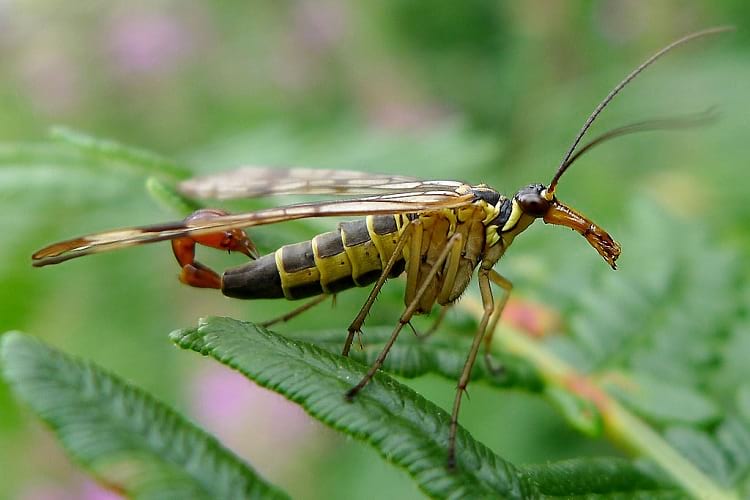
Common scorpionfly. (Gailhampshire / Flickr)
The Mecopterans, more commonly known as scorpionflies, are a very interesting species. Technically insects, they are called Scorpionflies because of the enlarged genitals of the male Panorpidae that resemble the stinger of scorpions. The distinct feature that sets them apart from other insects is due to the presence of a rostrum or a beak-like structure on their face.
Even though Scorpionflies have a tail that looks like a stinger, they do not sting or bite and, are quite harmless. The name Mecoptera is Greek for ‘long wings’. ‘Meco’ is Greek for ‘long’ while ‘ptera’ means ‘wings’. They were named by the eminent American Zoologist and Palaeontologist Alpheus Hall and, American entomologist Jennie Maria Arms in 1891. The name might include ‘fly’ but they do not belong to the family of flies.
The Mecopterans undergo a complete metamorphosis and are considered predecessors of other insects who go through a similar life cycle. The egg of the Mecoptera is said to expand as the embryo grows. This process can either take 5 to 10 days or, several months. The larva then grows in a damp area. It feeds on dead animals or sometimes on smaller insects. They approximately take 32 days to be fully grown, after which the larva digs a hole in the ground to pupate.
In the Pupa stage, it can move about in the shell or cocoon as the body is not attached to the shell. The fully developed adult leaves the shell after 10 to 15 days of completion of the metamorphosis. Though the adults are mainly carnivorous, they are also known to feed on petals, leaves, fruit, nectar, pollen, and in the case of the Snow Scorpionflies, even moss.
There are nearly 300 species of Mecoptera and nine families, though, some families are now extinct. They are commonly found in humid temperate and subtropical areas. The Scorpionflies do not exist in a large enough quantity to have any environmental impact and hence, are not classified under pests. There are three main families or types of Mecopterans.
The Panorpidae or the common scorpionflies
Being the largest family of Mecoptera, it is also the only family that has the scorpion-like stinger-tail in the males. The insects of this family are dirty-yellowish brown in colour with speckled wings. They feed on dead insects and male Panorpidae attract the females by vibrating their wings and offering a dead insect to the females to feed on.

A male scorpionfly. (Luc Viatour / www.lucnix.be)
The Boreidae, also known as snow scorpionflies
The only family of Mecoptera that is flightless and thrives in cold climates, so much so that they can die from the warmth of the human hand. They can be commonly found in snowy areas, cold mountains, and high altitude regions.
Dark brown or black in colour, they have long antennae but the wings are much smaller, sometimes reduced to bristles. Male Boreidae attract females by waving their antennae or bristles. They jump on the female and stay attached for up to 12 hours, to mate.

Female snow scorpionfly. (Gilles San Martin / Flickr)
Bittacidae or hanging flies
This particular species is so called as the insects are often found hanging from the undersides of leaves to catch prey. They are the only insects to use their clawed hind legs to catch their prey which are smaller insects. They have long wings and long legs. Male Bittacidae attract the females with pheromones and a prey to feast on. They are found on low bushes in moist areas.

Hangingfly. (Cody Hough / Wikimedia Commons)
The Importance of Mecoptera
It is said that before the evolution of bees and other insects that help in pollination, Mecoptera may have had an important role to play in pollinating plants. In the current era, however, Mecopteran adults feed on dead organisms. They are often, the first insects to arrive on a corpse which interestingly, leads to their importance in forensic entomology.
Forensic entomology entails the study of insects or anthropods in a post-mortem. It is a study of the age of the eggs or larvae deposited on the dead body and the time onwards of insect activity. Studying the insects or larvae and their developed stages help in determining the Post Mortem Index (PMI), the change in the decomposition of the body and sometimes also the cause of death.
Forensic entomology is a very important aspect of the criminal investigation and is said to be dated back to 13th century China, the mention of which is in Sung Tzu’s book, ‘The Washing Away of Wrongs‘. Incidentally, Sung Tzu is thought of as the ‘Founding Father of Forensic Science in China’.
Enjoyed this article? Also, check out “Madagascar Hissing Cockroach: An Unusual Wild Insect That Has Now Replaced Popular House Pets“.
Fact Analysis:
STSTW Media strives to deliver accurate information through careful research. However, things can go wrong. If you find the above article inaccurate or biased, please let us know at [email protected].
RELATED
- July 29, 2019 Hoosier Cavefish: The Blind Cavefish from Indiana Named after Their NCAA Basketball League
- November 20, 2019 Solifugae: Unique Creatures That Are Neither True Scorpions Nor True Spiders
 August 11, 2019 Zebroid: Strange Equine Hybrids That Make Their Parentage Shine
 November 17, 2018 Xenotransplantation: Transplanting Vital Organs from Animals into Humans
The post Insects from Hell: Mecoptera, the Fly with a Scorpion Tail appeared first on .
]]>The post Saving the Kakapo – The World’s Strangest Parrot appeared first on .
]]>
Kakapo parrot in Anchor Island, New Zealand. (Kimberley Collins / Flickr)
The Kakapo, is a unique species of gigantic, flightless, nocturnal and ground-dwelling parrot, endemic to New Zealand, might just be the world’s most enigmatic bird. It has got an owlish face contour that lives up to its widely proclaimed epithet “the night parrot”.
The flamboyant Kakapos emerge every night dashingly from their shrouded daytime roosts, trudging over the fern-laced timberland floor, flexing their robust feet to climb up the tree canopy looking for fruits, flowers, seeds, shoots, leaves and tubers.
During the austral summer (from December to February), the male Kakapos throng at the display sites called leks to go after mates, and their rumbling screams can be discerned resounding through the backwoods for miles around.
Those buoyant calls, which today are rarely being heard, might have been silenced completely, had it not been for the persistent and painstaking efforts of a trickle of scientists and volunteers frantically trying to save the species from the threats of dire extinction.
Near extinction
Similar to various other unique birds in New Zealand, the downright obliteration of Kakapo is attributed to huge destruction of natural habitats and reckless entry of predators.
Likewise, its slow-moving reproduction pace and elaborate mating process which most likely filled in as an effective and normal populace control when predators were non-existent, have only accelerated its extermination.
The ground-nesting bird, which was at one time, spotted frequently in New Zealand, has now been almost wiped out because of loss in their habitat and invasive animals and rodents like cats, stoats, possums, weasels and rats that were brought in primarily by the European and Polynesian settlers to New Zealand and made easily accessible meals of both birds and eggs.
The new entrants thus turned out to be a very big menace to the flightless Kakapo, which already had its evolution in a land that was devoid of mammalian predators. This also made them thoroughly long-lived, with the oldest Kakapo almost reaching 120 years.
Another factor that is closely related to the near extinction of the Kakapo is the fact that they breed very infrequently. This is due to the reason that the rearing of the chicks is largely contingent on the fruits of the native trees like rimu and pink pine that come to fruition every 2 to 6 years and Kakapos breed only during these occasions.
As for the lean times, the Kakapo’s normal eating regimen comprises of grasses, herbs and coarse leaves which unfortunately lack the sufficient nutrients essential for the nurturing of the chicks and therefore, a big number perishes.
The species nearly vanished from the scene by the end of the 1980s.
Conservation and extinction redressal approaches
The New Zealand Department of Conservation which is solely responsible for the management of national parks and other protected reserves had unveiled the ambitious Kakapo Recovery Program in 1989, basically to drive a colossal effort in boosting the Kakapo numbers to a healthy and stable level.
The project monitors and bands together for Kakapo care and safekeeping in three specific offshore islands namely Anchor, Codfish, and Little Barrier Island, the only possible places on this planet where Kakapo are currently known to remain in existence.
Until recently, there was a dearth of human settlements in these isolated islands. Even snakes, mammals or other predators were completely missing to devour these native birds or their eggs.
New Zealand adopted an extensive migration and security enhancement project as a means to come to the rescue of the imperilled Kakapo. The birds which were found to be thriving on inhabited islands of New Zealand were strategically and meticulously trapped and moved to the secure and sheltered islands where all the predators like feral cats and rats had been stamped out.
Only caretakers were allowed to dwell on these islands and human encroachment was strictly regulated. Even boats were prohibited from landing fearing ingress of rats.

Kakapo parrot being relocated. (Department of Conservation / Flickr)
Environmental and Evolutionary Biologists from the University of Glasgow, who are currently working with New Zealand’s Department of Conservation, produced a special dietary supplement keeping in mind the principal aim to augment egg production of the remaining few Kakapo.
From 1995 onwards, workers associated with the Kakapo Recovery Program have been keeping a conscientious and vigilant monitoring of the population levels, providing nourishment and care to the birds with supplementary feed and herbage, safeguarding the Kakapo inhabited islands from the onslaught of invasive predatory creatures and on many occasions lending a helping hand towards the treatment and recovery of chicks that are underweight, malnourished or sick.

Hand-feeding kakapo parrot. (Kimberley Collins / Flickr)
The distinctive nature of Kakapo and the restricted geographical ambit of these island species, by and large, had made them extremely unfortified to extinction. The program, therefore, placed a greater emphasis on the safeguarding of habitats, instead of captive breeding alternatives.
The breeding of Kakapo observed an impressive out-turn with the plans and initiatives formulated and put in place by the Kakapo Recovery Program.
To start with, Kakapo birds breed only when the pink pine and rimu trees in New Zealand yield an abundance of fruits whose berries are enriched with calcium and Vitamin D which are the vital nutrients for the settling birds and chicks.
The breeding was conducted on all the three islands simultaneously. Many Kakapos bred for the first time. All these factors helped in an appreciable increase in the total number of laid eggs.
Owing to the fact that the birds are vulnerable and fragile during the initial few months of their life, the Kakapo Recovery Program usually waits for round about six months since the hatching of the last chick to formally announce the number of surviving chicks to the aggregate populace.
Around 40 Kakapos have so far been rescued and 37 new chicks born, bringing the total number of surviving Kakapos to a relatively stable and sizeable 153, if not ideal as in 2018, spreading across the three predator-uninhabited islands.

Stephen Bragg with a clutch of young kakapo parrots. (Department of Conservation / Flickr)
Decades later, officials now confident with an immensely productive recovery program profess that this new baby boom is perhaps the most successful population flare-up since the beginning of the program.
The wildlife officials assert that improvised technology such as remote nest monitoring and smart transmitters has also enabled them to keep tabs on the behavioural patterns of the birds without impeding their natural bearings and movement with hands-on contact.
However, the highly complicated reproduction system still continues to be a humongous challenge to control Kakapo’s sustainability and survival.
The latest technological innovations have substantially helped the team to increasingly look after Kakapo in a perfectly non-invasive manner, and as their population flourish, these distinct tools and their contribution will be crucial.
Awareness buildup for kakapo parrot
The great uplifting news about the Kakapo does not stop there. The birds have invited a fair share of additional support and recognition, thanks to some Imgur users who have put on show a lot of love and fascination for the Kakapo birds.
They have taken to populating the website’s opening page with umpteen numbers of Kakapo GIFs in a bid to spread awareness and adoration for the endangered species.
The torrent of Kakapo GIFs and the tagged links to the donation page of the Kakapo Recovery Program have given rise to donations crossing over 3000 New Zealand Dollars in a very short span of time.
Numerous books and publications describing the plight of the endangered Kakapo have been brought out in the recent past.
And now the charismatic birds on the rebound have caught the general public attention all across New Zealand and beyond. Not long after a Kakapo named Sirocco was gotten on camera trying to befriend a BBC photographer.
The bird spontaneously had a Twitter account of its own generated, attracting a massive following of 15,000 fans, which is an unforeseen but a welcome slice of publicity towards the efforts being delivered to salvage the bird from the brink of extinction.
Enjoyed this article? Also, check out “Himalayan Monal: The Nine-Coloured Bird of the Himalayas“.
Fact Analysis:
STSTW Media strives to deliver accurate information through careful research. However, things can go wrong. If you find the above article inaccurate or biased, please let us know at [email protected].
RELATED
- April 8, 2019 The Manchineel Tree: One of the Most Toxic and Dangerous Tree in the World
 December 16, 2019 Vulturine Parrot: Preserving the Plumes of Pesquet’s Parrots
- March 6, 2019 The Silky Anteater: The Nocturnal Dweller of the Tropical Rainforests
- June 19, 2020 Tree of 40 Fruits: A Patchwork Canopy of Myriad Fruits
The post Saving the Kakapo – The World’s Strangest Parrot appeared first on .
]]>The post Noctilucent Clouds: Shining in the Summer Twilight Sky appeared first on .
]]>
Formation of Noctilucent clouds over Stockholm, Sweden during sunset. (Kevin Cho / Wikimedia Commons)
Noctilucent clouds also called the “night-shining clouds” are slight and indistinct occurrences which are observed in the uppermost atmospheric layers of the Earth. They comprise of tiny and delicate ice crystals and dust particles of extraterrestrial meteor smoke that return to the skies during an astronomical twilight. Noctilucent is a Latin word which more or less means “night-shining”.
The phenomenon can be observed only during the polar summer months at latitudes between 55 and 65 degrees in the northern and southern parts of the Equator. The clouds are visible when the sun while setting shines on them. They are formed at an altitude of 80-85 km (50-53 miles) below the mesosphere. The Mesosphere is known to be the coldest part of the atmosphere with temperatures hitting as low as −140°C.
The clouds often display a tenuous and meandering pattern that signifies the presence of forceful wind currents at that high altitude.
Initial sighting
The first sighting of noctilucent clouds was reported in the year 1885 when separate instances of observation happened in Russia and Germany. The event was sighted two years following the volcanic Krakatoa eruptions in the straits of Java.
Over the recent decades, both satellite and ground observations have suggested that noctilucent clouds manifest enhanced brightness. They are also found to have descended to lower altitudes and are now being observed at ever-increasing frequency intervals.

Noctilucent clouds, Sweden. (Gofororbit / Wikimedia Commons)
Theories revolving around the origin of noctilucent clouds
At first, the formation of noctilucent clouds was assumed to be caused by the distribution of the volcanic detritus of Krakatoa. This resulted in numerous picturesque sunsets. It had many alert observers watching and discovering the noctilucent clouds at these points in time. They were actually trying to make thorough studies and researches on the summer twilight sky. Scientists surmised that the volcanic ash had been beautifully revealed. This occurrence was observed after the water vapour and tropospheric dust was injected into the cold and dry upper mesospheric layer. The clouds persisted even after the volcanic embers settled down.
The observations that followed later pinpointed that the volcanic activity is not entirely related to the inception of the noctilucent clouds. Even now the claim of the volcanic link is found to be scientifically disputable. Alternatively, it has been conjectured that the emergence of the earliest evidence of noctilucent clouds is owing to anthropogenic climatic variations. Over the past 30 years, the observations hovering over north-west Europe show an increase in the number of such cloud formation in every summer season.
Competing for the anthropogenic explanation for these extensive occurrences of noctilucent clouds are opinions that centred on unrestrained greenhouse cooling happening in the middle atmospheric levels. It also hinted at the intensified origination of water vapour linked to the substantial release of methane and heightened mesosphere humidity. These were primarily associated with concentrated farming and agricultural activities.
However, scientists still don’t absolutely comprehend the composition of water ice crystals and how water can get that high in the atmosphere. They speculate the methane concentration that may be propelled higher into the mesospheric layer end up generating water and ice at such high altitudes. Furthermore, the fact that there is no evidence of sightings of the noctilucent clouds before 1885 adds to the mystery.
Before, the exhaust gases emanating from various Space Shuttles and rockets have likewise been observed in contributing to the arrangement of the noctilucent clouds.

Formation of noctilucent clouds 90 minutes after the launch of SpaceX’s Falcon 9. (Space Exploration Technologies Corporation / spaceweathergallery.com)
Positional and visibility aspects of the clouds
The best time to look for noctilucent clouds is late spring or early summer about 30 minutes after sunset towards the west. The clouds incandesce as shining white and pale blue tendrils across the dark twilight sky. This allows them to be distinguishable from the cirrus clouds that are visible only during the daytime as they don’t exhibit any luminescence.
noctilucent clouds happen in both the hemispheres on the two sides of the equator. They have been watched under a great many circumstances in the northern hemisphere. But surprisingly they were noticed for less than 100 times in the southern hemisphere. noctilucent clouds in the Southern hemisphere are more unclear with infrequent appearances. This is attributed to a lower populace and fewer land areas leading to a marked absence of eyewitnesses and fainter watching conditions.
Scientific research on noctilucent clouds
Scientists and researchers studying these clouds have incorporated the information collected from NASA’s AIM (Aeronomy of Ice in the Mesosphere) satellite. Launched in 2007, the AIM spacecraft was particularly designed to explore the noctilucent clouds. The satellite measured their methods of formation and probable connections to the global climatic changes.
The satellite has examined these clouds by utilizing different onboard instruments to gather data. This included elements like temperature, ice crystal size, atmospheric gases, the cloud’s changing patterns and the meteor dust that penetrates into the atmosphere.

Night-shining clouds In Northern Europe. (© Martin Koitmäe / Flickr)
Types of noctilucent Clouds
The clouds exhibit an eclectic variety of characteristic patterns and forms.
Type I – Veil: Exceptionally fragile and unstructured.
Type II – Bands: Elongated streaks, parallel or zigzag at little edges.
Type III – Waves: Firmly dispersed herring-bone structures bearing a resemblance to the sand ripples along a shoreline.
Type IV – Whirls: Wide-scale twisted or looped structures.
Type V – Amorphous: Sporadic, isolated and formless patches.
Striking features of noctilucent clouds
One of the most compelling visual aspects of the noctilucent clouds is their colour. This is essentially the end result of the vivid atmospheric effects engendered by the Sun’s strategic position below the horizon during the sunset.
On the horizon, where the base of the noctilucent clouds merges, one can experience red, yellow, orange, green and golden hues. In the higher layers the clouds sport amazing white and silver colours.
The top of the clouds has a stunning purple or electric blue canopy. The vibrant blueness is believed to be caused due to the absorption of sunlight by the stratospheric ozone layer. This amalgam of colours creates a delightful artwork against a sweeping canvas of stars.
Capturing the noctilucent clouds
Photos of noctilucent clouds can be effortlessly captured with the help of a digital camera tightly settled to a tripod; using 400 ISO provides great results or even a smartphone. An exposure from 3 to 6 seconds and a lens aperture configuration of f3.4 will typically get the job done.
Nonetheless, it is advisable to take a few shots of various exposures and choose the best one. When this is done an attempt can be made to create a breathtaking panorama by clicking some overlapping photographs.
Enjoyed this article? Also, check out “Light Pillars, an Insight into Nature’s Spectacular Optical Phenomenon“.
Fact Analysis:
STSTW Media strives to deliver accurate information through careful research. However, things can go wrong. If you find the above article inaccurate or bias, please let us know at [email protected]
RELATED
- November 22, 2019 Aurora Borealis & Aurora Australis: Nature’s Mesmerising Light-Show
- November 20, 2019 Solifugae: Unique Creatures That Are Neither True Scorpions Nor True Spiders
- July 17, 2019 The Lonar Lake: An Astronomical Marvel
- September 11, 2018 Cave of the Crystals: A Geological Wonder with Giant Shimmering Crystals
The post Noctilucent Clouds: Shining in the Summer Twilight Sky appeared first on .
]]>The post Iceberg B-15: The Largest Floating Object appeared first on .
]]>
2002: The edge of Iceberg B-15A, Antarctica. (NSF / Josh Landis)
In the month of March 2000, the routine process of glacier calving at Ross Ice Shelf gave birth to the biggest iceberg of all times, Iceberg B-15. The B-15 was of a gigantic size. It was 295 km long and was 40 km wide, accounting equal to a total surface area of 10,915 square kilometers, larger than the island of Jamaica. The Chicago Tribune reported that “Scientists estimated that the new iceberg contains an amount of freshwater equivalent to the average annual rainfall on the entire land surface of Earth”. Earlier in 1964, before the era of satellite photography, an iceberg having a length of 333 km and a width of 100 km was reported to be floating in the Antarctic but estimates have been termed as unreliable due lack of any hard proof.
Researchers have been backing a study that claims that long-term natural cycle gives birth to these gigantic icebergs once every century or so. But they also fear the hand of the rapidly warming globe in putting the process of glacier calving on a fast-track. The Antarctic usually harbours bigger icebergs than the Arctic as it offers vast spans of uninterrupted oceans water, but, of course, an iceberg of this size was an object of fascination to the world and the scientist alike.
Tracking iceberg B-15
Scientists had been tracking the cracks Iceberg of B-15 for a long time and were expecting it to break away anytime. Overtime (2000,2002 and 2003), the Iceberg split into many daughter Icebergs, B-15A being the biggest one. An Iceberg of this size offered huge possibilities. Icebergs help scientist to study and understand the ocean currents.
As a result, on 29 January 2001, GPS and weather instruments were installed on B-15 A to monitor the nature of the giant iceberg as it made its way through the Antarctic waters. This was the first time an iceberg was being observed this way. Icebergs could survive for 25 years if they keep themselves harboured at their birthplace, in the frigid waters of Antarctica. However, if they move northwards, they are attacked by warm waters from all sides, shrinking their life.

Researchers installing GPS on Iceberg B-15A to track its movement. (NSF/Josh Landis / Antarctic Photo Library, U.S.)
Challenges from large icebergs
No matter how peaceful these floating pieces of ice might seem, remember that it was an iceberg that sank the Titanic. The iceberg B-15 posed several threats since its inception. Perhaps the most significant one was to the cartographers of Antarctic. The daughter iceberg, B-15A, collided with the fragile Drygalski Ice Tongue on 10th April 2005, causing fracture and breaking off an 8 square-kilometer portion of the tongue’s mass. As a result, maps of Antarctic had to be redrawn.
Also, it made lives hard for the Adélie Penguins by blocking the pathway to open sea forcing them to travel a lot of distance to get back to their chicks and feed them. The result of this was catastrophic for the penguin population. The massive berg also blocked the route of supply ships, which supplied three research bases.
But, perhaps the most dangerous consequence that the iceberg poses is that it blocks the sunlight from reaching water, severely decreasing the production of phytoplankton. Also known as the microalgae, phytoplankton is the food producer of the marine food chain.
The fate of iceberg B-15
A study report of 2010 backs the fact that repeated grounding with the bathymetry near Cape Adare led to breaking up of the iceberg. Today, the might and grandeur of the B-15 has come to an end. Like any other iceberg, it met its fate. The iceberg split into daughter icebergs. Initially, only the major ones were tracked but still, the names of daughter icebergs went up till at least B-15 X.
But soon these daughter icebergs also started splitting, giving birth to smaller icebergs. The largest surviving fragment is the B-15T, accounting equal to a length of 52 km and width of 13 km. It was recently spotted by the NASA’s Operational Land Imager. 8 chunks from the original are claimed to be around the US National Ice Center (NIC). The agencies do not track icebergs smaller than 19 km and as a result, there might be thousands of pieces of B-15 floating around today.
Enjoyed this article? Also, check out “NASA’s Rectangular Antarctic Icebergs and the Data Scandal of Global Warming“.
Fact Analysis:
STSTW Media strives to deliver accurate information through careful research. However, things can go wrong. If you find the above article inaccurate or biased, please let us know at [email protected].
RELATED
 October 27, 2018 NASA’s Rectangular Antarctic Icebergs and the Data Scandal of Global Warming
 October 23, 2018 Halley Research Station: The First Floating, Relocatable Research Facility in the World
 July 13, 2019 McMurdo Station: The Largest Research Centre in the Antarctic
- January 31, 2020 Angel Oak: The Magnificent Giant Live Oak of Charleston
The post Iceberg B-15: The Largest Floating Object appeared first on .
]]>The post Solving the Mystery Behind the ‘Sailing Stones’ of Racetrack Playa appeared first on .
]]>
A rock that has left its trail in Racetrack Playa. (Giuseppe Milo / Flickr)
Racetrack Playa is a dry lake bed situated in Death Valley National Park, in the state of California, USA. It is a home to a rare and distinctive phenomenon. The rocks situated on the dry lake bed are found with long trails behind them, suggesting that they moved from one place to another mostly by sliding.
The trails appear to point in the direction that the rocks move involuntarily. Usually, no tracks leading to, or away from, the rocks are found, which eliminates any animal or human influence. Rocks weighing as heavy as 600 pounds (272 Kgs) were found to have moved.
Topography and climate
The surface of the flat lake bed is made up of silt and clay, which gives rise to a large volume of mud cracks as the conditions in the area is mostly dry. It is situated in a region with an arid climate, with the average rainfall of barely two inches a year. The mountains surrounding the Playa produce runoff because of the rainfall, which is accumulated on the playa, making it a small and shallow lake. The floor of this lake, naturally, becomes very soft and contains slippery mud, providing the perfect conditions for the rocks to relocate.
This possibly involuntary movement of rocks stoked the flames of different kinds of speculation. Theories have suggested the involvement of hurricane-force winds, rocks being carried away because of ice, or, inevitably, supernatural elements.
Theories and findings of Sailing Stones
Movement because of hurricane-force winds was the most favoured explanation, which was assumed to be a culmination of a unique set of circumstances. However, that theory was debunked based on the fact that these heavy rocks were embedded into the lake bed and wind alone would not have been sufficient. No one had scientifically verified any of the above theories until Richard Norris, and his cousin James Norris managed to record the movement of the rocks in December 2013.

The stones are also known to change directions. (Jon Sullivan / Wikimedia Commons)
Geologists have studied these rocks since 1948. Eventually, it was proved that this movement of rocks is due to the development of ice on the lake, and several other factors. First, the playa must turn into a shallow lake due to rains in the parched climate. Then, temperatures must fall low enough to form a thin layer of ice on that lake. In the end, the wind should blow with enough strength such that this thin ice breaks into floes and subsequently slide the rock across the water underneath the layer.
The Norris brothers, however, subscribed to the hurricane-force winds theory. The theory of ice floes isn’t new. Prior to the research by Norris brothers, a researcher named Ralph Lorenz from the John Hopkins University has made attempts to investigate the phenomenon. He had placed time-lapse cameras in the area. These cameras, unfortunately, couldn’t obtain a conclusive proof regarding the theory.
Richard Norris, the elder of the Norris brothers, is a paleobiologist at the Scripps Institution of Oceanography, and James Norris is a research engineer. “Slithering Stones Initiative” was launched by the Norris brothers in 2011. A weather station in the region was installed by them over a period of two years and equipped 15 stones with GPS devices which enabled them to record their movement and velocity.
Witnessing the sliding stones
Owing to a genuine stroke of luck, they managed to watch the stones move in December 2013 when they had actually come to check the readings on these GPS embedded stones. They published their findings in a journal called “PLOS ONE.” James remarked that he was “amazed by the irony of it all” that “In a place where rainfall averages two inches a year, rocks are being shoved around by mechanisms typically seen in arctic climes”. The movement of the rocks was slow with the speed of the rocks being as low as 15 feet per minute.

The direction of the rocks is determined by the wind. Hence leading to paths intersecting each other. (Gregory “Slobirdr” Smith / Flickr)

Image captured by the Norris brothers of rocks sliding in thin ice in 2013. (Richard D. Norris, James M. Norris, Ralph D. Lorenz, Jib Ray, Brian Jackson / Plos One)
They concluded that the occurrence of the motion of the rocks is extremely rare and the weather conditions that are required for the phenomenon are highly specific. Hence, the mystery of sliding rocks stands resolved, thanks to the Norris brothers’ research in 2013.
Enjoyed this article? Also, check out “Danxia Landform: China’s Rainbow Mountains“.
Recommended Read:
The Secret of Death Valley: The Mystery of Racetrack Playa: Volume 4 (Florea & Holland Mysteries) | By Mark Stephen Taylor
Recommended Visit (Caution):
Racetrack Playa | California, USA
Fact Analysis:
STSTW Media strives to deliver accurate information through careful research. However, things can go wrong. If you find the above article inaccurate or biased, please let us know at [email protected].
RELATED
- March 2, 2019 Wave Rock: Where a Massive Prehistoric Wave, Just About to Break, is Etched Permanently in Stone
- February 5, 2019 White Sands National Monument: Ace Military Testing Area and an Astounding Tourist Destination
- June 25, 2018 Tsingy de Bemaraha National Park: Natural Beauty of Stone Forest in Madagascar
- May 23, 2018 Danxia Landform: China’s Rainbow Mountains
The post Solving the Mystery Behind the ‘Sailing Stones’ of Racetrack Playa appeared first on .
]]>The post Ever Heard About the Darvaza Gas Crater That has Been Burning in Flames for the Last 50 years? appeared first on .
]]>
Darvaza Gas Crater at night. (Tormod Sandtorv / Flickr)
There are only a few sites in the world, which make you stop and wonder. ‘Door to Hell’ or ‘Gate to Hell’, the Crater of Fire, the Darvaza Gas Crater is one site in the world where one can watch fire flames erupting in the center of a desert. The ‘Door to Hell’ is located almost 266km away from Ashgabat city (capital of Turkmenistan). The Karakum Desert is known to be the 13th largest desert on the planet. It spans an area of approximately 15,440 square miles. Throughout the year, the 69 meters broad and 30 meters deep sinkhole remains in flames 12 months a year.
Origin of the fire in Darvaza Gas Crater
Records about its inception are imprecise. There are two prominent but different versions of the story behind its burning. Turkmenistan is known for its abundance in natural gas. The site was initially discovered in 1971 by Soviet geologists and determined that it was suitable for further exploration. But shortly after they established their base and began drilling, the site collapsed into itself forming this crater which began spewing noxious gases.
The scientists deemed these gases harmful to the community around it. They set the crater alight thinking that it would burn itself out within a few days, in an attempt to minimize the damage. But, the crater has been burning for more than four decades now. In an alternate version of the story, it is believed that the site was discovered during the 1960s and that it was set alight two decades afterwards, deeming it extremely difficult to establish a credible timeline of the events.
National Geographic’s crater exploration
In 2013, a Canadian adventurer named George Kourounis became the first man to have made his way into the crater. He later described his expedition to the National Geographic as ‘a coliseum of fire’.
In a statement given to the National Geographic, he mentioned that one could clearly watch ‘fires burning in smaller portions’. The sound coming from the crater was similar to that of the jet engine. According to George, in particular, the sound was more like that of burning gas.
He further stated that the inside of the crater had no smoke. In fact, nothing blocked his view and he noticed everything with much clarity. His adventure didn’t go in vain, as he managed to discover bacteria living at the bottom, comfortable with the harsh conditions that existed there. These bacteria weren’t found in the surrounding soil of the crater, making them a part of a little micro-ecosystem at the bottom of the pit.

Darvaza gas crater during the day. (Stefan Krasowski / Flickr)
Becoming a popular tourist attraction
People come from various parts of the world to see the burning crater. However, the site only amazes those who are in search of something never seen before. Despite the danger that the crater poses, the area is not bound by any kind of fencing or barricading. People are allowed to stand right at the very edge of the crater and take a good view of the burning flames. The site has attracted more than 50,000 people over the past 10 years.

A couple enjoying the view of the crater. (Sunriseodyssey / Flickr)
Visitors camp for a few days near the site at the Karakum Desert. One can see the radiance of the burning crater from a quite a distant. Also, the smell of burnt sulphur can be identified while approaching the crater.

The crater from a distant. (Mike Moss / Flickr)
In the year 2010, Gurbanguly Berdimuhamedow, the president of the country gave orders for closure of the hole, (citing fears that it would threaten the country’s natural gas fields). However, the hole has not been closed to date.
Enjoyed this article? Also, check out “Dallol, Ethiopia: Alien World on Earth“.
Recommended Read:
Turkmenistan: Far Flung Places Travel Guide | By Simon Proudman
Recommended Visit:
Darvaza gas crater | Turkmenistan
Fact Analysis:
STSTW Media strives to deliver accurate information through careful research. However, things can go wrong. If you find the above article inaccurate or biased, please let us know at [email protected].
RELATED
- October 22, 2018 Salar de Uyuni: The Incredible Salt Flats of Bolivia
- December 4, 2019 Great Blue Hole: Largest Underwater Sea Hole off the coast of Belize is a Diver’s Paradise
- January 5, 2020 Australian Bushfires: Deadly Yet an Inextricable Part of the Australian Ecosystem
- July 11, 2019 The Jewel of Manipur: The Loktak Lake is the Only Floating Lake in the World
The post Ever Heard About the Darvaza Gas Crater That has Been Burning in Flames for the Last 50 years? appeared first on .
]]>The post The Near Endangered Honduran White Bat of Central America appeared first on .
]]>
The Honduran White Bat. (Geoff Gallice / Wikimedia Commons)
Found within many countries of Central America, the Honduran White Bat – like many animals in the world today – is at the fear of extinction albeit at the safer end of the IUCN spectrum. The creatures are considered ‘Near Threatened’ on the International Union for Conservation of Nature scale. This means their struggle has not yet been taken seriously in terms of a worldwide acknowledgement. That is on the basis that even ‘Critically Endangered’ animals do not get sufficient attention with many species already extinct.
There are many reasons why this particular bat is special but one, in particular, is potentially beneficial to the human race. If that is a justified reason then these creatures should certainly be saved. And that is just one attribute which has been discovered. There may be more found once the elusive mammals are studied further.
Species profile
First we will have a look at the animals which many view with horror owning to the fact that many of their brethren are bloodsuckers. The famous myth of the Vampire contributes to this. However, these Hondurans are frugivorous, surviving almost exclusively on the fruit called ‘Figs‘. The largest to have been found are only 4.7 cm tall, extremely small and extremely light – at most, 5.6 grams.
They have almost all-white fur which is actually very uncommon; only five species of bats have this make-up. The main difference is the yellow parts on their face. In particular their ears, nose and lips. This colouring is caused by a chemical called carotenoids. Discovered in 1892, they are the first and only member of the Genus called Ectophylla which if you are interested in Etymology comes from the Greek for Leaf and Out – referring to its leafed nose.
Another name for this species is the Caribbean White Tent-Making Bat which illustrates its lifestyle. They make a habitat for themselves by cutting the vein of a leaf to make it fall into a tent shape. Nocturnal, they will roost here during the day and at night they will leave to look for food using the famous sonar system otherwise known as Echolocation (a similar system to dolphins and whales).
This tent system is extremely beneficial, keeping them protected from predators – an extremely intricate example of evolution. They remain in small colonies, clinging to the roof of the leaf until it dies and disintegrates. Although they will have a green hue within the leaf because the leaf is not completely closed they will sometimes be spotted by predators. However, if their white furs are spotted, many predators will assume them to be a wasp’s nest and stay clear. These predators include monkeys, owls, snakes and raptors.
As many as twelve bats can stay in the same tent for as long as 45 days which includes giving birth and guarding the young until they are fit to fly (which takes no more than 5 weeks). This is a small amount of their lifespan as although an exact number is unknown, members of the same genus can live up to seven years. And other species up to seventeen. Scientists believe these tent-makers to be somewhere in between these two numbers.

Honduran White Bat roosting under the leaf of Heliconia latispatha. (Leyo / Wikimedia Commons)
Why is the Honduran White Bat important?
As mentioned, the most important fact about these mammals relates to human health. So far they are the only animals discovered to be able to generate a visible colour change. The yellow parts; ears, nose and lips come from a chemical called carotenoids. The Honduran White Bat can perform a mechanism which uses this chemical to change skin pigmentation. The conversion of it is said to protect their retinas and conserve eyesight.
As contrary to popular belief bats have fully functioning eyes, they are just more active at night. The phrase ‘Blind as a Bat’ being a popular misnomer. Lutein is the name of said carotenoid which is found in the fruit eaten by the bats. It has been found that the animals are able to covert that Lutein into an esterified version which has many beneficial properties. With human eyesight, another well-documented problem, finding out how the bats convert this Lutein could solve many problems among humans and other animals.
A problem here is that the bats are threatened due to human expansion. Deforestation of the rainforests in particular, with farmlands taking over much of the land. As their diet is so reliant on fig trees this makes it difficult for them to adapt. Without mentioning whether losing a species like this is unjust or not, as it the case with many plants and animals they have desirable traits which could benefit mankind. Alas, these are dwindling as their ecosystems change and every day more and more secrets are lost forever.
Enjoyed this article? Also, check out “Hoatzin Reptile Bird: A Dinosaur-Like Bird with the Digestive System of a Cow“.
Recommended Visit:
Tortuguero National Park | Costa Rica
Fact Analysis:
STSTW Media strives to deliver accurate information through careful research. However, things can go wrong. If you find the above article inaccurate or biased, please let us know at [email protected].
RELATED
 December 24, 2019 Scaly-foot Gastropod: A Snail with an Iron Armour That Lives Near the Hydrothermal Vents
- July 11, 2019 The Jewel of Manipur: The Loktak Lake is the Only Floating Lake in the World
- March 2, 2019 Wave Rock: Where a Massive Prehistoric Wave, Just About to Break, is Etched Permanently in Stone
 May 27, 2020 Bartini Beriev VVA-14: The Cold War Scramble for Arms Gave Birth to an Amphibian Aircraft in Russia
The post The Near Endangered Honduran White Bat of Central America appeared first on .
]]>The post Tsingy de Bemaraha National Park: Natural Beauty of Stone Forest in Madagascar appeared first on .
]]>
Karst limestone of Tsingy de Bemaraha National Park. (Rod Waddington / Flickr)
There is an interesting game of one-up-man-ship between man and nature. Man wants to win over nature forgetting he himself is a part of nature. Nature, on the other hand, is equally adamant and resolute in guarding her sovereignty. Titillated by harrow, Earth laughs with a harvest. Equally, ravaged by time and tide, Earth can bare her fangs, to protect her flora and fauna and her self. An example is Stone Forest in Madagascar, nature’s throwback to man’s burning of woods. `Come on! Burn this stone forest if you can’, says nature. Man is stumped, and badly at that.
Welcome to Tsingy de Bemaraha National Park Madagascar, a 666 square Kilometer area located in western Madagascar and a UNESCO World Heritage site. Former French overseas territory, and now a large island, about 500Km long off the coast of Mozambique, Madagascar is a biodiversity marvel. Ninety percent of the life forms found here can’t be seen at any other place on earth.
A safe haven for wildlife
When forest vegetation on this geographical area was razed down by man to grow rice, dislocated life forms, so it seems, found shelter in the Stone Forest. Tsingy de Barah sprung up as nature’s rebuttal to man’s abuse of natural resources.
Tsingy in Malagasy (the native language of Madagascar) means – (where) you can’t walk without shoes (protective gear) or ‘walking on tiptoes’. The moniker is a stark reality for any explorer or research scientist who has set his foot on this reserve can vouch for. Ragged multistoried rocks with razor sharp uneven surface, serrated limestone pillars shooting up to 100 meters in height, a mountainous terrain replete with sinkholes, fissures caves and spires are hallmarks of this National Park.
Winding, labyrinthine and spiky pathways in the bowels of forest are a nightmare for anyone out there to test his stamina and endurance in exploring the unknown and unchartered pathways. The park is extremely patronizing for the inmate plants, insects, birds and animals which may have perished but for the care and protection showered on them by Mother Nature, courtesy Tsingy de Bemaraha National Park. As man is clearly intimidated and overwhelmed, this area is sweet home to a wide diversity of life forms in high-density habitations.

The lethal Tsingy rock formation. (Rod Waddington / Flickr)
Formation
Limestone rocks in this part of Madagascar (4th largest island in the world) got invaded with the rising table of underground water, creating horizontal and longitudinal cuts in the deep interior of rock masses. A wet-dry tropical climate tempered this change, causing, in course of time, formation of deep fissures, caves, caverns, and pointed limestone projections shooting high into the skyline.
If Earth had a set of teeth, it must be these limestone needles radiating from a compact group of mountains (Massif). This geomorphic fencing protects many rare and endangered species of plants and animals living and thriving here. Maze of prickly pathways, steep heights, uncanny cliffs, slopes and the eerie feel of the area is enough to send a shiver down the spine of any first time visitor.
Flora and fauna at Tsingy de Bemaraha National Park
But for the guided tour of the area presently in vogue, it would be a no entry zone for humans; a fitting closure for mankind that destroyed 90% of the natural habitat of the region for pecuniary gains. Life forms uprooted from wild consequent upon the annihilation of forests for agriculture and logging could live and flourish in these multistoried rock formations – looking like a chain of cathedrals carved by nature.
This range of limestone jigsaw is home to a population of organisms 85% of which are just not found anywhere else in the world, and 47% are exclusive only to a particular area of the massif. Vegetation ranging from deciduous dry forest to vast grasslands, bushes and wooden climbers abound in myriad locations of Tsingy mountain range.
As for animals, their diversity and uniqueness is mindboggling. Close to 25000 species, many of these ‘endangered’, frolic and bloom in abominable innards of this stone forest. At the very top, we find 11 species of lemur, jumping from one calcareous pinnacle to another. A rare mongoose-like mammal, falanouc, a ring-tailed mongoose and myriad bats inhabit their specific zones in this magical land of Indian Ocean.
Another variant mongoose, Fossa, measures 6 feet from tail to nose, weighs 12 KG and looks more like a cat than a mongoose. It scurries through foliage using its tail as balance pole. Placed in the red list of threatened species by IUCN, stone forest is one and the only abode on earth for this mongoose with looks of a cat. Comet moth or Madagascan moon moth is an astonishing creature with a wingspan of 20 cm. It is one among the largest moths world over. Panther chameleon can change colour to a range and degree which no other lizard worldwide can match. Satanic leaf-tailed gecko, the wonder snake, is a camouflage icon. It blends so well with its environment that predators are easily conned. Brightly colored tomato frogs, nocturnal primates aye-aye, the bird Madagascar fody, Madagascar long-eared owl, lowland streaked tenrec – a hedgehog-like mammal with long pointed snout, painted mantella – the frog with green, black, yellow or orange colored skin; are some unique creatures living in the expanse of park’s largely unexplored hostile environment.

Lemurs of Tsingy National Park. (Stephan Waeber / Flickr)
How Tsingy evolved?
Apart from anthropological reasons, these organisms owe their distinctive characters to tectonic shifts because of which they evolved in relative isolation with rest of the world. Madagascar was part of Indian peninsula 88 million years ago when it broke away from Madagascar-Antartica-India landmass. Earlier to that, 200 million years ago, the region was limestone seabed which would pop out as the sea water receded, making it a terrestrial bed. Subsequently, it morphed into mountains of cathedral limestones, the natural reserve now called Tinsgy de Bemaraha.
It is located in Antsalova district of central-west Madagascar. Home to 80,000 hectares of dense, dry forest, the region is an ultimate marvel of karst (limestone) system. Its biological uniqueness has given it the epithet of `the eighth continent’.
Tsingy is a perfect example of how nature can go malignant following consistent exploitation by human hands and survive worst of geomorphologic upheavals. Realization world over to leave nature to herself hasn’t come a day too soon. Yet, late is better than never.
Enjoyed this article? Also, check out “The Jewel of Manipur: The Loktak Lake is the Only Floating Lake in the World“.
Recommended Read:
Madagascar, 10th: The Bradt Travel Guide | By Hilary Bradt
Recommended Visit:
Location: Tsingy De Bemaraha National Park, Madagascar
Recommended Watch:
Madagascar (TV series) | BBC
Fact Analysis:
STSTW Media strives to deliver accurate information through careful research. However, things can go wrong. If you find the above article inaccurate or biased, please let us know at [email protected].
RELATED
- July 11, 2019 The Jewel of Manipur: The Loktak Lake is the Only Floating Lake in the World
- October 22, 2018 Salar de Uyuni: The Incredible Salt Flats of Bolivia
- July 10, 2018 Solving the Mystery Behind the ‘Sailing Stones’ of Racetrack Playa
- March 31, 2019 The Cano Cristales: Colombia’s Extraordinary River of Five Colors
The post Tsingy de Bemaraha National Park: Natural Beauty of Stone Forest in Madagascar appeared first on .
]]>The post Dasht-e Lut: A Martian Terrain and the Hottest Place on Earth appeared first on .
]]>
Dasht-e Lut desert in Kerman Province, Iran. (Erik Albers / Wikimedia Commons)
Alfons Gabriel, a Viennese physician and adventurer, found himself spellbound by Iran’s Lut desert during the 1920s and 1930s. He wasn’t the only one. Seven centuries ago, famed traveller Marco Polo made his journey through the desert on a camel’s back. Gabriel’s dreams of conquering the central Lut Desert saw light on March 1937. He barely made out alive from a place he later called “a confused mass of impassable tangled dunes.”
Weather and topography
The Lut Desert in the southeast Islamic Republic of Iran takes the crown of being the hottest place on Earth. Here the mercury rises up to 70 °C (159 °F) and it is hot enough to fry an egg. Also known as Dasht-e Lut, Persian for “Emptiness Plain,” the Lut Desert spans up to an area of 5,400 sq km and is bereft of wildlife and vegetation.
On July 17, 2016 UNESCO inscribed Dasht-e Lut in the World Heritage List. Despite its scorching temperature and abiotic living condition, the Lut desert is an arid beauty with rock formations, salt plains, and sand dunes inching upwards and standing tall at 300 meters. A wide variety of dunes are displayed here. These include linear, compound crescentic, star, and funnel-shaped dunes. A nebkha dune is also formed here when sands are trapped around plants.
Since the desert is an arid subtropical area with almost no vegetation the strong winds blowing between June and October creates some visually stunning aeolian yardang landforms. A yardang is similar to sand dunes but it is elongated and its steep side faces the wind direction. It’s a Swedish explorer Sven Anders Hendin who is credited with introducing the word yardang to the English language. The yardangs in the Lut desert are so large that its magnificence can be viewed from the space.

Yardang in Dasht-e Lut Desert. (Ninara / Flickr)
This desert is also known for its sinkholes, parallel ridges and furrows in contrast to the eastern part of the desert which is a low plateau with salt flats. With no one around to monitor the temperature in this parched area, maintaining a weather station is impractical.
However, Moderate Resolution Imaging Spectroradiometer (MODIS) on NASA’s Aqua satellite measured the temperature from 2003 to 2010, during which it was found to have the hottest surface on Earth. The highest temperature recorded was 159.3 degrees Fahrenheit (70.7 °C) officially recorded in 2005.
The hottest region in Dasht-e Lut
The hottest part of Dasht-e Lut is a 480 km² area called ‘Gandom Beryan’ which means scorched wheat in Persian. There is a local legend regarding the origin of the name. A caravan of camels carrying loads of wheat had an accident due to which they had to leave their wheat in the Gandom Beryan area. Few days later the abandoned wheat caught the attention of another caravan passing by. By then the wheat had scorched due to heat, the place got its name thereafter.
Although the region has in past been called a place of “no life,” one where even bacteria don’t form a culture, there exists flora and fauna adapted to survive these harsh conditions. A team of researchers found that beneath the bone-dry landscape lies a “hidden sea” a shallow layer of saltwater that may help sustain life.

Caravanserai, a resting place for travellers in Dasht-e-lut. (Erik Albers / Flickr)
Conservation and protection
Visiting Lut Desert is off limits during summer and come winter the temperature plummets below zero. Not being easily accessible to the major population centre coupled with its extreme weather conditions leaves much of Lut desert easily protected. Settlements are allowed only on the western part of the desert. Apart from that, the state owns a greater part of Lut desert. A buffer zone has been established with 15 villages and Shahad town with nearly 6000 dwellers.
The Forests, Range and Watershed Management Organization; the Iranian Department of Environment; and the Iran Cultural Heritage, Handicrafts and Tourism Organization (ICHHTO) are the three principal agencies sharing conservation and management responsibilities. ICHHTO has inscribed the Lut Desert on its national heritage list. The responsibility of preventing illegal exploitation of desert falls under the Forest, Range and Watershed Management Organization.
It’s been noted through findings from climate change module that as temperature rises, tracts of the uninhabitable area in the Middle East will expand.
Enjoyed this article? Also, check out “Vast Oil Reserves Buried Under Rub’ al Khali the Largest Sand Desert in the World“.
Not Recommended Visit:
Dasht-e Lut | Desert in Iran
Fact Analysis:
STSTW Media strives to deliver accurate information through careful research. However, things can go wrong. If you find the above article inaccurate or biased, please let us know at [email protected].
RELATED
- August 31, 2020 Ennedi Plateau and Aloba Arch: Home to Exquisite Natural Formations and ‘Extinct’ Animals
- February 16, 2019 Devils Hole: The Only Wild Habitat in the World Where the Endangered Devils Hole Pupfish Are Found
 September 3, 2019 Tomb of Bibi Jawindi: On Cross Roads of Islamic Ethos
- September 5, 2018 Insects from Hell: Mecoptera, the Fly with a Scorpion Tail
The post Dasht-e Lut: A Martian Terrain and the Hottest Place on Earth appeared first on .
]]>The post Danxia Landform: China’s Rainbow Mountains appeared first on .
]]>
Danxia Landform: Zhangye National Geopark. (lwtt93 / Flickr)
Zhangye Danxia Landform Geological Park is located in the Gansu province of People’s Republic of China. Sprawling over an area of over 200 sq. miles, the park houses a rare geographical feature which draws attention worldwide. The colours on these mountain ranges appear as if they were painted. Danxia, which means ‘rosy cloud,’ is an appropriate name given to this landform seen in China. The Rainbow Mountains belong to Cretaceous era, much before the formation of Himalayan Mountains. The Cretaceous sandstone depositions present in China contained high concentrations of iron and trace minerals that formed the basis of these colours that appear today. About 55 million years ago, the Eurasian plate struck the Indian tectonic plate which led to the formation of the Himalayas and these Rainbow Mountains.
The layered arrangement and horizontal stratigraphy were disrupted by the collision that elevated these hidden sedimentary rocks from the bottom of the Earth. In due course of time, weathering and erosion removed the overlying layers of siliciclastic rocks and brought out the underlying, distinct formations with different mineralogy and chemical composition displaying the striking colour difference seen in the mountains today.

Zhangye National Geopark. (Lwtt93 / Flickr)
Natural coloring agents
The primary deposition found in the area is deep-red sandstone. The red pigmentation of the sandstone is because of iron oxide coating and cementation. Cementation refers to the process in which the pores present between the grains of a constituent are sealed due to a precipitate buildup, binding the grains together in that place. The iron oxide, also known as hematite, is lodged between the grains of the sandstone giving it a deep-red colour. The formation of this iron oxide can be attributed to weathering and a reaction due to exposure to moisture and oxygen, similar to rust. However, a minor change in the chemical composition may cause the variance from the characteristic deep-red colour of sandstone. For example, oxidized limonite or goethite results in yellow or brown staining in sandstones, whereas the presence of iron sulfide imparts metallic yellow colour and chlorite or iron silicate clays forms the green colour. Hence, the upliftment of mountains and formation of deposits of several other salts, coupled with weathering and erosion for millions of years led to the formation of this spectacular Rainbow Mountains that we see today. However, Rainbow mountains form only one part of the whole Danxia landform.
Other attractions at Danxia landform
The Danxia landform is unique to China that can be observed prominently in the sub-tropical region of south-east China, within a crescent-shaped arc that approximately extends to 1700 kilometres. It comprises six regions: Langshan, Danxiashan, Longhushan, Chishui, Taining, and Jianglangshan. The Danxia landform was listed as a World Heritage Site by the UNESCO in 2010. Structures such as peaks, towers, cliffs, valleys, and arches made of deep-red sandstone rock by natural factors is a unique characteristic of the Danxia Landform.

Mount Danxia. (Dunley / Wikimedia Commons)
Planning to visit?
The nearest airport to this natural wonder is in Zhangye City, facilitating the tourists interested in visiting the rainbow mountains or the other parts of Danxia landform. The view is at its best when the sun is fully out with no cloud cover, especially at sunset. Between 6:30 pm and 8:00 pm, the colours attain additional shine and contrast, due to a perfect mix of shadows and light. The officials of the national park provide a bus which moves from one viewpoint to another and tourists are advised to stick to these locations specified by the officials. The ideal time to visit would be summer, between the months July and September, as the best amount of sunlight strikes during this period.
Enjoyed this article? Also, check out “Wave Rock: Where a Massive Prehistoric Wave, Just About to Break, is Etched Permanently in Stone“.
Recommended Visit:
Danxia Landform Geological Park | China
Fact Analysis:
STSTW Media strives to deliver accurate information through careful research. However, things can go wrong. If you find the above article inaccurate or biased, please let us know at [email protected].
RELATED
 April 6, 2018 Kangbashi, Ordos – Ghost City? Economic Ingenuity? Or Both?
- June 27, 2019 Traditional Yaodong, Shaanxi Province: The Cave Dwellings in Which Many Chinese People Still Live
- November 11, 2019 Bristlecone Pine: The Oldest Trees of Our Planet
- July 10, 2018 Solving the Mystery Behind the ‘Sailing Stones’ of Racetrack Playa
The post Danxia Landform: China’s Rainbow Mountains appeared first on .
]]>The post Dallol, Ethiopia: Alien World on Earth appeared first on .
]]>
Dallol crater was formed when basaltic magma intruded into salt deposits and water causing a huge phreatic eruption. (Michael Meraner / Flickr)
When we talk of places to visit in Africa, Ethiopia hardly ever makes it to the top of the list of the sought after places. Let’s not forget that Ethiopia is the birthplace of the human race, that fact alone should make it, if not the most, then one of the most popular tourist destinations in the world. But even that does not come close to make Ethiopia the most interesting place in the world. There is something else out there, what looks like a piece of an alien planet right here on Earth. What’s surprising is that this place has gone unnoticed for so long.
Dallol, situated in the Northern Ethiopian rift valley called Dalanik Depression, is home to world’s most extraordinary topographical features created by volcanic eruptions over time, the latest being in 2011. Caused by volcanic explosions of a different kind, Dallol crater was formed when the basaltic magma meddled with salt deposits and water which caused a large phreatic eruption. A phreatic eruption is when rising magma makes contact with the groundwater and the magma being extremely hot, causes the water to evaporate immediately. This led to a huge explosion of rocks, ash, water and steam as well as volcanic bombs (the molten rock gets cooled and solidifies before hitting the ground).
This volcano is surrounded by mountains of Sulphur, salt pillars, small gas geysers along with acidic hot springs and pools of acid separated by salt ridges. Put all these together and you get one remote uninhabitable place with one of the most bizarre and colorful landscapes in the world. A great variety of dazzling colors are seen at the site. White yellow, green and red ocher because of sulphur, iron oxide, salt, and other minerals.

A great variety of dazzling colours are seen at the site because of acid, salt and minerals. (Hervé Sthioul / Wikimedia Commons)
A huge salt desert surrounds the volcano, the edges of which are covered with a swarm of fairy chimneys where gases have broken through. The hot springs of sulphur foam at boiling point. The salt from the Danakil Depression, which lies 410 feet below sea level, mixes with minerals like sulfur and iron, to create a terrain of extraterrestrial concretions. The site is embellished with geysers and chimneys throughout.
Extreme environment
While the list of reasons for visiting Dallol if not long is interesting and colorful enough, the reasons to stay away from are equally interesting. It is not just the alien backdrop and the name which literally translates to disintegrated, that keep people from living here, Dallol also holds the record for the highest average temperature ever recorded for an inhabitable location.
Starting from 1960 to 1966, Dallol had the average temperature of 45°C. The environment is hostile to humans because of the unbearable heat and the possibly toxic fumes that fill the air.

Other attractions include Lake Karum (salt lake). (Michael Meraner / Flickr)

4×4 is the preferred mode of transportation to reach the required destination. (Michael Meraner / Flickr)
Planning to visit?
The fall of Haile Selassie, former emperor of Ethiopia in 1974, was followed by political instability accompanied by coups, uprisings, drought and famine in the country for a next few decades, discouraging tourists from visiting Ethiopia. The tension between Ethiopia and Eritrea does no favours either for the tourism in this region.
The number of people visiting this region every year is limited to just a few hundred. Reaching there is no easy task in itself even if you do away with all the safety concerns. You can either get there by hitching a lift on one of the camel caravans which passes Dallol, or you can rent a 4-wheel-drive from Mekele, a nearby town, which is a one day drive.
Maybe it is the isolation that has been enjoyed by Dallol has helped preserve the landscape for this long.
Enjoyed this article? Also, check out “Fairy Circles: The Systematic and Symmetrical Circular Arid Grass Formations“.
Recommended Watch:
Danakil Desert: The Hottest Place On Earth | BBC
Not Recommended Visit:
Dallol | Ethiopia
Fact Analysis:
STSTW Media strives to deliver accurate information through careful research. However, things can go wrong. If you find the above article inaccurate or biased, please let us know at [email protected].
RELATED
- July 17, 2019 The Lonar Lake: An Astronomical Marvel
- February 21, 2019 Lake Baikal: The World’s Deepest Lake That Holds 22-23% of the World’s Freshwater
- January 15, 2019 Pink Lakes: Where Rose-Tinted Lakes Surrounded By Lush Greenery Are Truly a Sight to Behold
- October 22, 2018 Salar de Uyuni: The Incredible Salt Flats of Bolivia
The post Dallol, Ethiopia: Alien World on Earth appeared first on .
]]>