The post Six Flags New Orleans: The Theme Park That Was Abandoned after Hurricane Katrina appeared first on .
]]>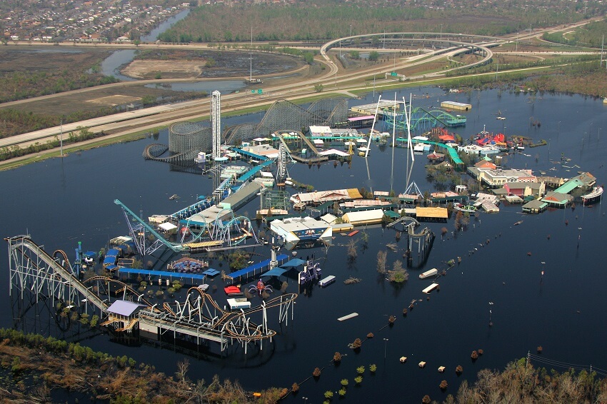
Aerial view of the now-abandoned Six Flags New Orleans theme park. (Chris Woodrich / FEMA Photo Library)
Bounties of nature are blessings. Even the ravages of nature are a blessing, albeit in disguised as a tragedy. So, when New Orleans city of America was hit by Hurricane Katrina, the state administration woke up to its lapses of commission and omission. And realized that it was more of a manmade disaster than a natural calamity. The theme park ‘Six Flags’ built on the sea coast, and ravaged by a hurricane, will now be modelled into a seat of learning about the environment and adventure sports.
The amusement park was hit by Hurricane Katrina
The park was ill-fated right from the beginning. Inaugurated in the year 2000, under the name Jazzland, it went bankrupt in just 2 seasons. Thereafter, in 2003, it was taken on lease by Six Flags, the largest amusement park company in the world. Two years later, in 2005, the park was hit by Hurricane Katrina. Damage caused was huge and irreparable. Hence, the Six Flags was forced to abandon the amusement park.
The tropical cyclone, Katrina, began as a depression over the Bahamas, the island country in the Atlantic Ocean, on 23rd August’ 2005. In the next 2 days, fierce winds blew at 119-154 Km/hr. in Florida, the southernmost state of America. On 27th, the storm intensified in the Gulf of Mexico and became category 3 hurricane with winds blowing at a speed of 185 Km/hr. Very soon, it became the most powerful Atlantic storm ever with winds lashing the Gulf of Mexico with a speed of 275 Km/hr. On 29th August, the hurricane progressed to category 4 in the southeast of New Orleans.


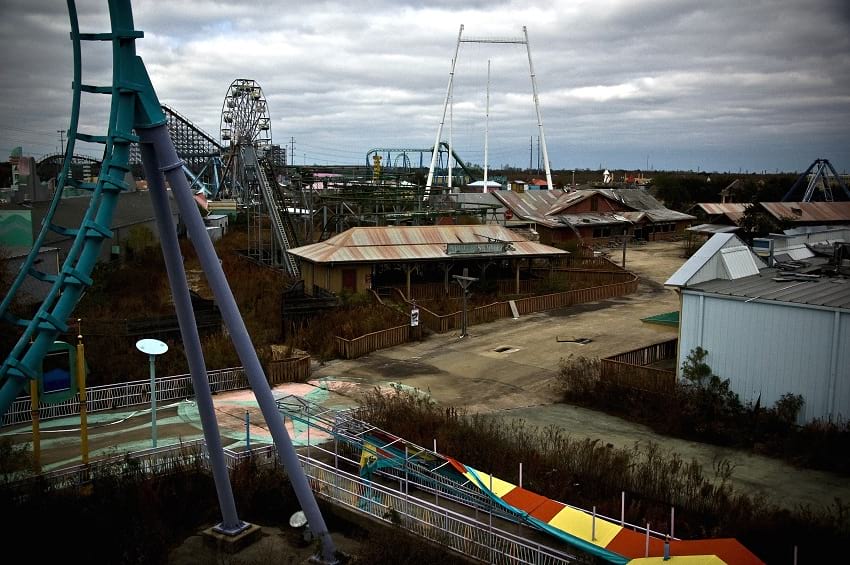

Photos of the abandoned Six Flags New Orleans. (Nathan Hoang / Flickr)
Related: How is the intensity of tropical cyclones estimated?
New Orleans was already flood-prone
Experts had warned much in advance that most of the urban settlement in the city of New Orleans was low lying and prone to flooding. Global warming was causing the sea surface to expand and eat into coastal areas in the course of time. The advice wasn’t taken seriously. Some even believed the city would not be hit by Katrina. But that was not to be, and hell broke loose in the city of New Orleans. New Orleans wasn’t directly hit by Katrina, it was collateral damage that did it in. The 10 inches of attendant rain was too much for the embankment (levee system) put in place to check to the flood of the city’s metropolitan area which was already located below sea level. As the levee system failed, the water of Pontchartrain and Borgne lake rushed in, inundated 20% of the city by the afternoon of 29th August.
Huge loss of life and property in spite of the warning
Mayor of the city, a day earlier, had sounded alert and ordered all inhabitants to move out of the city for safety. About 1.2 million inhabitants followed orders and moved out of the city. But about 10 thousand, willy-nilly, stayed put. And, by 30th of August, 80% of the city was submerged in water. In that situation, the local state administration couldn’t extend the required help to the affected people. With the city’s administrative machinery paralysed, there were instances of looting and arson. People perched on rooftops were salvaged by helicopters. The deluge and its aftermath claimed 1,800 lives. Material damage was to the tune of 160 billion dollars. By far the costliest natural disaster recorded in American history.
The resurrection of the park was impracticable
The Six Flags: New Orleans, situated on low lying 162 acres of land became a ready container for the surge of water flowing from a higher level. The drainage pumps installed in park failed and soon it became a pool of floodwaters, 4-7 feet deep. Material damage was huge. 80% of the park buildings were demolished. Prolonged contact with saltwater corroded the metal of fun gadgets and rides installed in the theme park. Repairing and restructuring the damage was deemed untenable. And the possibility of restarting the amusement park in future was put to rest.


Photos of the abandoned Six Flags New Orleans. (Nathan Hoang / Flickr)
The ruined park became a public nuisance
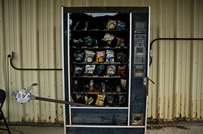
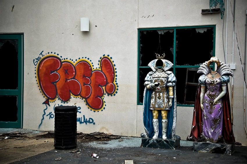
There are people who revel in exploring the deserted and the abandoned urban sites. It is their way of having a first-hand feel of ruins which were glorious in their heydays. Could the remains of park cater to such people, and become a destination for urban exploration (Urbex)? No. Reason being wanton pilferage, and take-away in the name of souvenir, which would invariably happen in urbex. Also, because the area of the decrepit park isn’t safe for the visitors. It is flushed with wildlife like alligators, snakes, wild hogs, rabbits and insects. For the people living in the neighbourhood, as of now, the park is an eyesore, a festering wound that must be treated as soon as possible.
Is Six Flags New Orleans reopening?
At present, the desolate park is closed for visitors. Entry to the site is declared illegal. In the year 2016, the possibility of reviving the Six Flags Park, and attracting investors for same, was thoroughly explored. But to no avail. Therefore, it was finally decided to remove all traces of what remains on-site as a remnant of the erstwhile Six Flag’s funfair.
Mayor of the city of New Orleans, LaToya Cantrell, declared in May this year that the leftovers of the park would be demolished to clear the ground for another establishment. The exercise would cost 1.3 million dollars to the state exchequer. The evacuated land would be used to establish an institution land for creating awareness about climate change. It would also be a school for zipline courses on adventure sports, and guided tours to the nearby wildlife refuge.
Special thanks to Nathan Hoang from Flickr for releasing the photos of the abandoned theme park in creative commons.
Fact Analysis:
STSTW Media strives to deliver accurate information through careful research. However, things can go wrong. If you find the above article inaccurate or biased, please let us know at [email protected].
RELATED
 February 13, 2020 Hashima Island: A Once Bustling Japanese Metropolis That Now Reminisces Its Hauntingly Tragic Past
 July 2, 2019 Varosha: The Abandoned Luxury Retreat in the Mediterranean
 February 8, 2019 Al ’Ula Town: A Once-Flourishing Oasis That Now Lies in Dust, Hidden from the World
 May 22, 2019 The South China Mall: Why Did the Largest Mall in the World Fail?
The post Six Flags New Orleans: The Theme Park That Was Abandoned after Hurricane Katrina appeared first on .
]]>The post Hashima Island: A Once Bustling Japanese Metropolis That Now Reminisces Its Hauntingly Tragic Past appeared first on .
]]>
Aerial photo of Hashima Island. (kntrty / Flickr)
History has been witness to a lot of prosperous towns and flourishing cities in the world, which have now been rendered uninhabited. Ghost towns (or cities), as people like to call them, these abandoned places have always left behind tales of tragedy that the modern world finds very intriguing. One such ghost town is located off the Southern Japanese city of Nagasaki called Hashima Island, which is one of the other 505 deserted places in the whole of Nagasaki Prefecture.
General information about Hashima Island
Hashima Island goes by the name Gunkanjima in Japanese language, where gunkan in English translates to ‘battleship’ and jima or shima means ‘island’ in English. The shape of the island, officially called Hashima, resembles the Japanese warship Tosa and so the name gunkan-jima or Battleship Island came to be associated with it. Situated approximately 15 kilometres away from Nagasaki port, Hashima Island has many haunting memories that former residents now have to share with the world. But long before the island wore a deserted look, it was home to some 5,300 odd people, making it one of the most densely populated places in the world at that time. Spreading across 61,000 square metres, the island thrived during the early 1800s, when undersea natural coal reserves were found to be in abundance surrounding the island.

Hashima Island is sometimes also referred to as the warship island. (mahlervv / Panoramio)
Gunkanjima is surrounded by a high-standing, steel reinforced concrete seawall, which protected it (and still does) from the regular, powerful typhoons in the middle of the ocean. The silhouettes of concrete buildings dotting the entire island, which were constructed for families of labourers, give it the look of a warship from a distance. The island measures approximately 480 meters in length and is 150 metres wide. Nature has now taken its course and covered some of the concrete structures, but the dilapidated buildings and belongings of the residents still remain to tell their shocking stories, perhaps best left unheard.

Hashima Island from a different angle. (kntrty / Flickr)
The mining operation at Hashima Island
Although coal was first discovered deep beneath the seabed surrounding Hashima Island in the year 1810, industrial mining began only in the late 1800s. The first inhabitants landed on the isle in 1887 and three years later in 1890, corporate giant Mitsubishi Mining Company purchased the island and took control of it for coal mining purposes. Mitsubishi Corporation’s coal mining operation lasted successfully for more than eight decades, even surviving two major world wars. But soon enough, the coal reserves started to deplete during the 1960s and also due to the rise in the newly-accepted petroleum products, Mitsubishi announced that the mining operation would be closed down. And so in the year 1974, Hashima Island was abandoned with people returning to the mainland one after the other, leaving their belongings as they were where they still lay untouched.
Early occupancy and abandonment of Hashima
Initially, when Mitsubishi started the coal mining process, it began ferrying labourers to the island and back to the mainland. But the daily tiresome procedure gave way to sweeping changes and Mitsubishi Corporation decided to build housing facilities for families of the labourers on the island itself to make it easier and more convenient. Work was in plenty and miners were willing to stay back on the island with their families and so the plan of expansion materialized. A lot of concrete residential places and many industrial buildings quickly started cramming the entire island. Hashima was complete with schools, cinema halls, shops, sports facilities, hospitals, graveyards, temples, swimming pools and even separate playgrounds for children.

Hashima Island. (kanegen / Flickr)
As the company steadily flourished, Mitsubishi not only provided for people’s living but made food, water and electricity available to them at no cost. The residents only had to take turns cleaning and maintaining public places on the island. People had job security and a source of income to run their families and life was easy on the island. But soon it all fell on desperate times. An ordinary high ocean wind would send the residents into periods of misery. They depended on the outside world for everything, right from food, clothing and fresh water to other daily necessities and storms would prevent ships from sailing into the island with supplies. The lack of indigenous vegetation and soil, too, prevented them from growing vegetables on the island, which changed in 1963, when soil was brought in from the mainland and citizens on the island could then cultivate and start eating their own produce.

Abandoned building in Hashima Island. (ajari / Flickr)

Close up photos of the abandoned buildings in Hashima Island. (ajari / Flickr)
The ghost island might now look like it had been in the middle of a catastrophe, but that was never the case. The island was not abandoned overnight but the telltale signs look like it had been emptied all at once. Dusty bicycles still lean against the walls where they were parked inside homes, along with personal pictures on walls, bottles, kitchenware and electrical appliances gather dust as they lay rotting away. At school, stationary and writing equipment lay scattered near the broken desks and benches, all covered in dust. Buildings look like they might crumble anytime, while playgrounds with broken rides seem to wait for children to return. Former residents claim that when Mitsubishi Corporation had decided to shut shop at the island, it had promised the inhabitants work on the mainland, which would be purely based on a first-come-first-serve basis. That is how people left the island with most of their belongings where they were in a bid to get a job closer home in the city.
Controversies surrounding Hashima Island
Hashima Island has become a very famous tourist spot now, but back in the day, it was shrouded in mystery and had a dark past with heartwarming stories. During Mitsubishi’s booming industrial coal mining stint, World War II had broken out and there was no way the company was backing out of such a lucrative deal. With many Japanese youths gone away to join the armed forces against the Allies, Korean and Chinese citizens were brought in on the island in large numbers to fill in for them. These ‘foreign citizens’ were brought in as wartime labourers and forced to work at the undersea coal mines, where they had to endure a lot of hardships.
Former workers, who were very young at that time, say that the conditions in the mines were very exhausting and thegruellingg schedules included them to endure heat, humidity and extreme temperatures inside the excavation sites. The ceilings of digging places hung very low and workers had to bear excruciating pains while they crouched down to mine. The food provided was only two handfuls of poor quality rice balls, which they had to make do with on a double shift. Labourers were sometimes even subjected to beatings in case they tried to relax.

A building in Hashima Island, 1930. (Series of Japanese geography and folk culture: Vol.13)
As per local records, as many as 1,300 Korean and Chinese citizens, who were made to suffer slave labour at the mines, died between 1925 and 1945 due to some or the other tragedy at the island. Some died in underground accidents, others due to illnesses and some more due to malnutrition and exhaustion. Some others even tried in vain to escape by jumping over the seawalls into the ocean below. Former wartime slaves from Korea and China later demanded compensation and reparation charges from Mitsubishi Corporation but the company insisted that all demands had been met by signing of the postwar treaties.
Sightseeing at Hashima Island
After the island was left with nothing but ruins, it was shut down entirely only to reopen to the public officially in the year 2009 as a tourist place. A host of private companies ferry visitors to Hashima Island from Nagasaki Port on a two-way boat trip that takes approximately two hours in total. Sightseers are only allowed to take a 45-minute-long tour on the southern side of the island from three observation decks installed. Tourists are forbidden from straying too close into the ruins for risk of buildings collapsing any time. During rough weathers, landing on the island is not allowed and sometimes, boats do not operate or ferry passengers at all.
UNESCO World Heritage Site
Despite the island’s gloomy past, Japan pushed to include Hashima Island into the list of UNESCO’s World Heritage sites in 2009. It justified that the island marked the country’s industrial revolution but Korea opposed the inclusion stating that the site was nothing more than a disgraceful place where forced labour was carried out. After a lot of pushing and pulling, through a compromise between the two countries, Hashima Island was finally included in the coveted list at a World Heritage Committee in Germany in 2015. It was here that Japan accepted its murky truth and confirmed what Hashima actually faced over all those years.
Recently, the island was featured in the James Bond movie ‘Skyfall’, which brought it into prominence across the world. But the objectionable business that Japan carried out in the name of coal mining still makes people shudder. Those that experienced life on the secluded island for decades might never be able to rub off the haunting memories of their past, but Hashima Island stands in decrepitude, telling the tales of its once successful empire.
Enjoyed this article? Also, check out “Thilafushi: The Good, Bad and Ugly of the Garbage Island of Maldives“.
Fact Analysis:
STSTW Media strives to deliver accurate information through careful research. However, things can go wrong. If you find the above article inaccurate or biased, please let us know at [email protected].
RELATED
 October 17, 2018 The Horrors of Hiroshima Bombing: Human Shadow Permanently Etched in Stone
 July 31, 2018 Seppuku: The Japanese Suicide Ritual, Where Death is Better Than Disgrace
 December 12, 2018 Dhanushkodi: Where a Cyclone Ripped Apart an Entire South Indian Town, Rendering it Uninhabited
 July 14, 2019 Unit 731: Gruesome Human-Experimentation To Test Biological And Chemical Warfare In Japan During WWII
The post Hashima Island: A Once Bustling Japanese Metropolis That Now Reminisces Its Hauntingly Tragic Past appeared first on .
]]>The post Concrete Bunkers Peppering the Country of Albania Are a Glimpse into Its Communist Past appeared first on .
]]>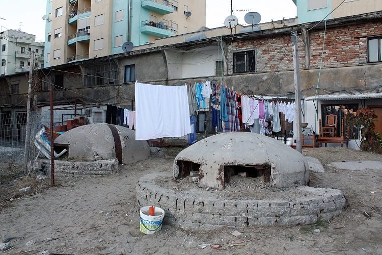
Bunkers near the residential area are a common sight in Albania. (Edal Anton Lefterov / Wikimedia Commons)
The concrete bunkers of Albania are an omnipresent entity that can be located all over the country – in the middle of the streets, in the middle of fields and even on people’s lawns. These bunkers or bunkerët were largely constructed between 1960 to 1980. At the time, Albania was ruled by a communist government which was headed by the left-wing ideologue, Enver Hoxha. By 1983, around 175,000 to some 750,000 bunkers had been constructed all over the country. Hoxha’s program of bunkerisation involved constructing bunkers in every nook and cranny of the country of Albania. Bunkers were constructed deep in the Albanian countryside and also right on the pavement of city streets.

A large bunker in the countryside. (David Stanley / Flickr)

Bunkers in Vermosh, a village in Albania. (Sigismund von Dobschütz / Wikimedia Commons)
Although so many bunkers were constructed during Hoxha’s regime, none of them were used for their intended purpose. On the contrary, the process of bunkerisation was an unnecessary drain on the country’s already dwindling economic resources. Constructing the useless bunkers diverted funds away from more pressing needs like Albania’s housing problem and the pitiable condition of Albanian roads. After the collapse of communism in 1990, most of the bunkers were abandoned and now stand derelict and decaying. However, some are being put to good use as animal shelters, shelters for the homeless, cafés and residential projects.
Hoxha’s Regime
Led by Hoxha, Albania withdrew from the Soviet Union after Nikita Khrushchev started the process of De-Stalinization, which was known as the Khrushchev Thaw. The Khrushchev Thaw was a period of the early 1950s where the Soviet Union relaxed censorship, repression and released political prisoners. Enver Hoxha was a hardline Stalinist and his brand of communism was influenced by elements of Maoism as well. In 1968, Hoxha also withdrew Albania from the Warsaw Pact after the Warsaw Pact countries invaded Czechoslovakia. Albania also cut off cordial relations with China after US President Nixon visited China in 1972. Albania was also perpetually in a state of war with Greece. One of the reasons for this hostility was that Greece was a member nation of the North Atlantic Treaty Organisation (NATO) established in 1949. Hoxha was also incredibly critical and hostile towards the communist government established in Yugoslavia by the moderate dictator Josef Broz Tito. As Hoxha was a hardline Stalinist, he accused Tito of maintaining a chauvinistic attitude towards the Party and the State.
Hoxha was also growing increasingly paranoid of Albania being invaded by Yugoslavia, the Warsaw Pact countries or NATO. According to Hoxha, Yugoslavia wanted to invade Albania and make it their 7th province. Also, Hoxha talked about the persecution and imprisonment of ethnic Albanians living in Kosovo. Hoxha introduced a new constitution in 1976 that increased the Labour Party’s stronghold upon the country, the military and also severely limited the ownership of private property. Under Hoxha’s regime, the country sank into a situation marked by paranoia, isolation and economic stagnation.
The process of bunkerisation
Starting in 1967, the Hoxha regime began the process of bunkerisation or bunkerizimi. Hundreds of thousands of bunkers were constructed all over the country. They were built in virtually every location – beaches, mountains, vineyards, pastures, villages, towns, city thoroughfares and even on the manicured lawns of Albania’s best hotel. As discussed earlier, Hoxha was incredibly paranoid about Albania fending off a two-front invasion against Yugoslavia, the Warsaw Pact countries and NATO which would involve a simultaneous attack by eleven enemy airborne divisions. Hoxha implored his citizens to be increasingly vigilant and also took drastic steps so that citizens could be militarised effectively.

A man resting against a typical bunker on the street of Albania. (Jeroenvrp / Wikimedia Commons)

Bunkers in the park. (Meriboo / Wikimedia Commons)

Bunkers in Dhërmi, Albania. (isalea / Flickr)
Hoxha’s role during the Albanian Resistance during World War II now took mythological proportions and was used as a rationale for the excessive militarisation and bunkerisation. The Albanian Resistance’s war strategy was guerrilla warfare based in the mountains where soldiers would stay hidden and raid vulnerable areas in the plains. To protect Albania’s sovereignty, the main intention of the bunkers was to provide defensive positions all over the country where Albanian soldiers could take refuge. The small bunkers were constructed in such a way that they would remain in sight of a much larger command bunker, which would be permanently staffed. Communications would be achieved by radio and visual signals.
Out of the total population of 3 million citizens, Hoxha’s regime effectively militarised 800,000 of them. From a very young age, Albanians were fed propaganda and were taught to be vigilant. From the age of 12, citizens were trained in how to station themselves in the nearest bunkers to fight invading soldiers. Civil defence drills were held regularly – at least twice every month, which would last up to three days.
Construction of the bunkers in Albania
The bunkers were made of concrete, iron and steel and varied in size. There were the smallest bunkers with gun slits that could only fit one or two persons. On the other hand, large underground nuclear bomb shelters were also constructed that would be used by the Party Leadership and bureaucrats.
QZ Bunkers
The most common bunker type is the smallest version, known as the Qender Zjarri or QZ bunkers. It is a small concrete dome set into the ground with a spherical bottom that extends downwards. The components of the QZ bunkers were prefabricated and were then assembled at the designated location. QZ bunkers were generally constructed in groups of 3 and placed in strategic positions all over the Albanian coast, linked to each other by a concrete tunnel. The city of Tirana was heavily guarded, with thousands of bunkers radiating out in fifty concentric circles around the entire city.

Diagram of the “Qender Zjarri” type of bunker. (Elian Stefa, Gyler Mydyti / Wikimedia Commons)
PZ Bunkers
The command-and-control bunkers were known as Pike Zjarri or PZ bunkers. These were much larger and heavier than QZ bunkers, weighing 350-400 tons. These were also prefabricated and assembled on-site. The largest among the PZ bunkers had a diameter of 8 metres.

Diagram of the “Pike Zjarri” type bunker. (Elian Stefa, Gyler Mydyti / Wikimedia Commons)

A PZ bunker converted into a home by a poor family, 1994. (Albinfo / Wikimedia Commons)

Entrance to the PZ bunker. (Dennis Jarvis / Flickr)

The interior of the PZ bunker. (Dennis Jarvis / Flickr)
Special bunkers
Special bunkers were also constructed that were nuclear bomb-proof and were designed to protect Party members and upper-level bureaucrats in the event of an invasion. Near the capital, a 2-mile network of secret tunnels and bunkers was constructed to protect the politicians and the members of the Sigurimi (secret state police).
The process of bunkerisation was incredibly expensive and put a huge dent in Albania’s already weak economy. The country was just recovering from the massive damage it incurred during the Second World War. Hoxha’s paranoia badly affected the lives of 3 million Albanians. Isolation, fear, oppression and paranoia were the ruling tenets during Hoxha’s oppressive rule of forty years. When General Beqir Balluku, the Defence Minister, publicly criticized the bunkerisation program, Hoxha had him arrested, convicted and executed. In present-day Albania, the bunkers are used as pizza ovens, solar heaters, beehives and cafés.
Enjoyed this article? Also, check out “Prora: Hitler’s Colossal Resort by the Beach That Never Served Its Purpose“.
Fact Analysis:
STSTW Media strives to deliver accurate information through careful research. However, things can go wrong. If you find the above article inaccurate or biased, please let us know at [email protected].
 Recommended Read:
Life is War: Surviving Dictatorship in Communist Albania | By Shannon Woodcock
Genre:
Non-fiction > History
RELATED
 July 16, 2019 Communism in Indonesia: The Destruction of the PKI
 September 11, 2019 Maginot Line: The Mark of French Tenacity and Resilience
 March 26, 2019 The Disappearing Aral Sea and its Abandoned Ships
 November 9, 2020 Six Flags New Orleans: The Theme Park That Was Abandoned after Hurricane Katrina
The post Concrete Bunkers Peppering the Country of Albania Are a Glimpse into Its Communist Past appeared first on .
]]>The post Varosha: The Abandoned Luxury Retreat in the Mediterranean appeared first on .
]]>
Varosha, Famagusta. (Zairon / Wikimedia Commons)
In the abandoned southern side of Cypriot City, Famagusta lies the deserted city of Varosha. It is quite famously known as the ‘Mediterranean’s best-kept secret’, quite an appropriate title taking into account the city’s fascinating history. Once upon a time, Varosha was the place to be for the world’s rich and famous. The splendid beaches and the glitz and glitter of luxury were the hallmarks of this retreat. Long stretches of sand and hundreds of luxurious rooms to pick from, ensured this paradise for the rich never stayed vacant for long. All the big names at the time found themselves in this spectacular resort city; starting from Richard Burton and Brigitte Bardot to Elizabeth Taylor. However, the idyllic business of the luxury retreat came to a halting end with the division of Cyprus in 1974. Left abandoned, the Varosha lies tucked away in its nostalgia and memories.
Varosha today: A real-life dystopia
It has been forty years since the city last heard the carefree giggles of people strolling down the streets, their arms loaded with shopping bags. The city of Varosha has become akin to what dystopic movies try to bring to life on screen. In an interview, Ceren Bogac explained that it felt as though she was neighbours with ghosts while growing up in a house next to Varosha. She describes how the houses had pots, flowers, and curtains but no one lived inside. If a ball ever crossed into the city limits, it was gone forever. It was almost as though the story of “The Boy with the Striped Pajamas” had come true.
Ceren Bogac grew up with haunted memories of the paradise that used to be. This led her to eventually go on to build the Famagusta Ecocity Project along with Vasia Markides. “You’re seeing nature take over. Prickly pear bushes have overrun the entire six square kilometres. There are trees that have sprouted through living rooms. It’s a ghost town…” says Vasia Markides, one of the few inhabitants of the now abandoned city.
Varosha is currently under Turkish forces, and entry to the public is banned with orders to shoot on sight. There are photographs that prove how much of a ghost town the city really is. Other than Turkish soldiers, there are a few adventurous souls who have managed to wander into the city, bringing back anecdotes. There is a car dealership that is still fully stocked with 1974 cars. Window displays have mannequins that are dressed in a fashion that is long gone. Clothes hang on wires, while rotten food is still found in pots. An entire city is left to succumb to the ravages of time.

Abandoned buildings. (Zairon / Wikimedia Commons)
Paradise lost
The city of Varosha had a populace of around thirty-nine thousand people at last count. The prominent John F. Kennedy Avenue housed several well-known hotels including the King George Hotel, and The Grecian Hotel, frequented by celebrities year round. The Argo Hotel was famous as Elizabeth Taylor’s favourite hotel to stay in.
The military combat on 20th July 1974 resulted in a victory for the Turkish army, and the Greek Cypriot army then retreated to Larnaca. Hours before this encounter, the inhabitants of Varosha fled fearing a massacre. All thirty-nine thousand people ran away from their homes with the hope that they could someday return.
As Vasia Markides says, “Anyone who comes from Varosha has a romanticised notion of it.” Survivors tell tales about how they had left pots of food cooking on the stove, and then their entire life came to an abrupt stop. Now peering back from over the fence, this erstwhile paradise has given way to a land of utter ruin.
The UN Security Council Resolution 550 of 1984 had ordered the Turkish Army to hand over Varosha to the administration of the United Nations. They also ordered that the city would be inhabited only by the ones who were forced to abandon their homes to save their lives. The Turkish Army, however, refused to comply and instead uses the city to their advantage to ensure Cyprus abides by their own terms.
The Famagusta ecocity project: An attempt to rebuild
The city of Varosha is currently encircled with a barbed-wire fence, leaving a major section of land out to waste. Vasia Markides, an American-Greek Cypriot hailing from Famagusta, built the Famagusta Ecocity Project together with Bogac. The project aims to reopen the city, while at the same time abiding by the two sides that govern the area.
The ultimate aim of the project is to rebuild Varosha, keeping sustainability in mind, and promote peaceful co-existence between the inhabitants of the place. The base model is of a modern-day ecopolis, and the eventual goal is to make it Europe’s model ecocity. There are three main aims that Markides is striving to achieve- peacebuilding, economic prosperity, and environmental sustainability.

View of Varosha. (A.Savin / Wikimedia Commons)
People from a wide arena of professions are involved in the project, including some of the best architects, economists, urban planners, and conflict-mediation specialists. The best in every imaginable field plays a crucial part in this project, aiming to bring forth nothing but perfection.
Infrastructure within the city remains quite intact. However, nature has taken its course, finding ingrowths amidst the already existing architecture. Drainage systems and transport systems are some of the more vital aspects of the project. Private car – centred Varosha of the past needs to be revamped in the vision of a sustainable and environment-friendly future. With sustainable development as a primary objective, the project naturally incorporates bicycle riding roads, tram lines, and public transport as part of the design revamp.
An important remnant of the past
Varosha’s past is so intrinsically entwined with its essence, a modernised version of the city might lose its ‘soul’. This is a major point to be considered during restoration. A walk down its bylanes is almost a literal walk down memory lane- with the city’s history preserved within every cobblestone and building in sight. The city of Varosha stands as a proud witness to precious history- of culture and violence, opulence and oppression.
Enjoyed this article? Also, check out “Kolmanskop: From Being the Richest Town to Now Being Devoured by the Desert“.
Fact Analysis:
STSTW Media strives to deliver accurate information through careful research. However, things can go wrong. If you find the above article inaccurate or biased, please let us know at [email protected].
RELATED
 February 14, 2019 Kolmanskop: From Being the Richest Town to Now Being Devoured by the Desert
 January 25, 2019 Pripyat, Ukraine: The Thriving Soviet Nuclear City That the Chernobyl Disaster Turned into a Ghost Town Overnight
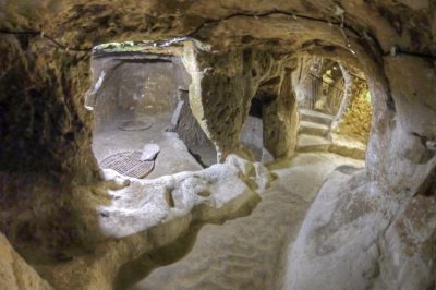 April 17, 2020 The Ancient Multistory Underground Cities of Turkey Housed Thousands of People
 December 28, 2018 Hakan Sukur – The Superstar Striker Exiled by Erdogan
The post Varosha: The Abandoned Luxury Retreat in the Mediterranean appeared first on .
]]>The post The South China Mall: Why Did the Largest Mall in the World Fail? appeared first on .
]]>
South China Mall. (David290 / Wikimedia Commons)
As China makes its way towards becoming an economic power to reckon with, it is inevitable that it will encounter a few hiccups along the way. One such hiccup was the South China Mall, a massive retail project that failed to live up to its potential.
The South China Mall
When the South China Mall opened in Dongguan in Guangdong Province in China in 2005, the Chinese, as well as the foreign media, celebrated it as the largest mall in the world. With a total building area of 9.6 million square feet and the capacity to host 2350 stores in 7.1 million square feet of this space, it certainly is a behemoth. It is thrice the size of the Mall of America, which is the largest mall in the United States, and was expected to cater to a much larger public. It retained its crown as the largest mall in the world until the Dubai Mall overtook it in terms of area size.
Unfortunately, unlike the Dubai Mall and the Mall of America, the South China Mall has not so far enjoyed the widespread success its developers expected. Despite having pre-leasing agreements with around 1016 stores, the mall opened with only 386 stores. The much-publicized crowd of 200,000 plus people per day never materialized. Over the next ten years, the stores that had leased space in the mall closed or went out of business, and over 99% of the mall space remained empty. It became apparent that the mall was a losing proposition and the Western media began to deride the place as a colossal failure.
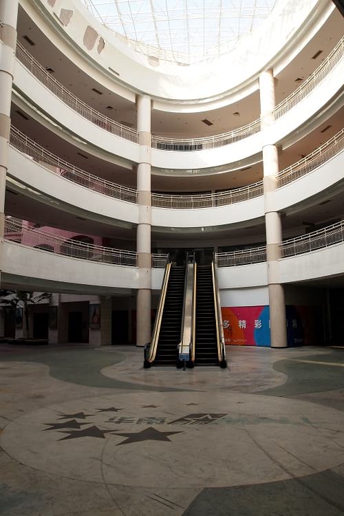
An escalator at South China Mall. (Remko Tanis / Flickr)
Building the biggest mall in the world
The South China Mall began as the brainchild of the Chinese millionaire Hu Guirong. Having made a fortune from instant noodles, he decided to take a hugely ambitious foray into the retail business. The mall was his maiden venture. Since he originally came from Dongguan in Guangdong province and had great pride in his hometown, he wanted to build something so big and amazing that it would put the place on the world map and attract people from all parts of China as well as from around the world.

The now abandoned South China Mall. (Milowent / Wikimedia Commons)
His company, Dongguan Sanyuan Yinghui Investment & Development, took out a financing loan of a billion yuan (around $154 million then) from the Agricultural Bank of China for building the mall.
It is very likely that the loan approval was influenced to a great extent by a feasibility study carried out by Guangzhou’s SMR Group. According to this study, the prospective mall was likely to attract over 200,000 customers per day, and more than a few of these would be shoppers from nearby Guangzhou and Shenzhen. Yes, the researchers who conducted the feasibility study appear to have believed that people would come daily from these cities. That they would prefer to shop at the new mall in another city, rather than at the many malls closer to their homes. The study appears to have been based more on wishful thinking than on practical realities.
In any case, the idea of building the largest mall in the world appealed to the Chinese government as well. Once they had made their approval clear, the bank did not bother further about the project’s economic viability. They just made out the loan to Mr.Hu.
Mr. Hu’s company spent over $1.3 billion in constructing the mall. They sent out design experts to malls around the world to review and gather the best building ideas. The final design of the mall included seven international zones where shoppers could experience the thrill of walking through replicas of the European cities of Amsterdam, Rome, Venice, and Paris, not to mention through faux versions the Caribbean and Egypt. To give visitors a European experience, the builders constructed replicas of famous landmarks like the Arc de Triomphe from Paris, a Venetian canal complete with gondolas, and St. Mark’s bell tower from Venice. Then, to amuse the crowds further, they also added a 1,814 feet roller coaster.
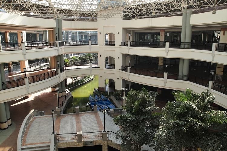
The artificial canal outside New South China Mall. (Remko Tanis / Flickr)
Later, in December 2006, when it became more than apparent that the mall was a failure, Mr. Hu sold a 50% controlling interest in the mall to Peking University’s Founder Group. For all practical purposes, this meant the Chinese government had stepped in and taken over to save face. Given the amount of international publicity that the mall’s opening had generated, they couldn’t very well let the mall fail. In September 2007, the Founder Group changed the mall’s name from ‘South China Mall’ to ‘New South China Mall’ and hoped for the best.
If you build it, doesn’t mean they will come
There is a well-known maxim – Build it, and they will come. That hasn’t been true for the New South China Mall in the ten plus years since its opening. The only places in the mall that see a trickle of visitors are a few restaurants like McDonald’s, KFC, Pizza Hut, and Kungfu, the IMAX film theatre, a small amusement park for children, and a former parking area that is now a Go-Kart track.

The empty Teletubbies Amusement Park at the mall. (Remko Tanis / Flickr)
The rest of the mall – almost 99% of it – remains empty, and the security guards discourage people from visiting these unoccupied areas. The available staff is, apparently, unable to keep up the complex maintenance, and much of the infrastructure is deteriorating and crumbling. The snaking canal is growing green with algae growth. Old faded decorations remain in place and add to the overall gloom.
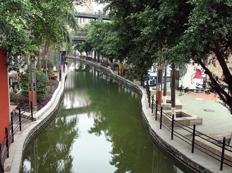
Algae bloom in the artificial canal. (David290 / Wikimedia Commons)
Reasons why the South China Mall failed
While Mr. Hu certainly appears to have had laudable intentions, neither he nor his team seem to have given much thought to various practical aspects regarding the project’s feasibility. For a mall to succeed, it has to be in an area where there are enough consumers, and it must be easy to access. The general public must also find the mall itself simple to navigate. People should be able to move about easily through its various sections without feeling trapped or lost. The New South China Mall scores low of all these aspects.
Let’s consider the issue of demographics
Migrant workers make up a large percentage of the population in Dongguan. They work hard in the nearby factories for average wages of $200 per month and send a good portion of these earnings to their families back home. They have neither the leisure time nor the disposable income to spend in a luxury mall.
Regarding the matter of shoppers visiting from Shenzhen or Guangzhou, that was an unrealistic expectation. There are many large malls in those regions. They, therefore, have no incentive to travel to Dongguan.
Another aspect that the mall developers overlooked is that the Chinese are, in general, savers not spenders. Also, only a minuscule percentage, as compared to the entire population, is wealthy enough to splurge on luxury goods for the snob value.
The issue of location
Built on what was formerly agricultural land in Wanjiang district in Dongguan in Guangdong province, the South China Mall is situated some 55 kilometres away from the city centre in an out of the way location that is not easy to reach. To get there from Dongguan, the city residents must travel for about two hours and, moreover, change a few buses to complete the journey. And after that, since none of the local buses go directly to the mall, they have to get off about one kilometre away and walk for 15 to 20 minutes to get to the mall. The bus fare for this distance is not cheap. Taking a taxi is even more expensive and necessitates paying toll fees to the Dongguan Development Company Limited.
Various journalists and travellers from outside China have found reaching the mall to be a big headache. Doubly so, as the locals were unable to give them the exact directions. For all practical purposes, the largest mall in the world is not even on the radar of most people in Dongguan.
Other issues plaguing the mall
Malls generally rely on big-name stores to act as anchor stores to draw in the crowds. In the case of the South China Mall, while several big-name stores did have a pre-lease agreement with the mall management, they never took up tenancy at the mall. Likewise, Shangri-La Hotels reneged on their promise to open 5-star facilities in the mall complex.
Can the biggest mall in the world resurrect?
Anything’s possible, so who knows? At present, the mall management is concentrating on attracting the local Chinese middle-class, and this might prove to be a more successful strategy.
Enjoyed this article? Also, check out “Kangbashi, Ordos – Ghost City? Economic Ingenuity? Or Both?“.
Fact Analysis:
STSTW Media strives to deliver accurate information through careful research. However, things can go wrong. If you find the above article inaccurate or biased, please let us know at [email protected].
RELATED
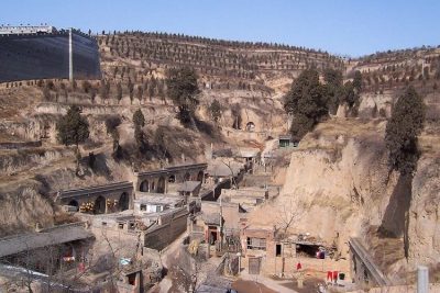 June 27, 2019 Traditional Yaodong, Shaanxi Province: The Cave Dwellings in Which Many Chinese People Still Live
 April 6, 2018 Kangbashi, Ordos – Ghost City? Economic Ingenuity? Or Both?
 May 6, 2019 China’s ‘One Belt, One Road’ – The Economic Project That Might Reshape the World
 June 22, 2019 Rape of Nanking is One of the Most Brutal and Forgotten Genocides of 20th Century
The post The South China Mall: Why Did the Largest Mall in the World Fail? appeared first on .
]]>The post What Happens to the Olympic Venues in the Host Countries After the Olympic Games End? appeared first on .
]]>
Abandoned swimming pool at Olympic Village Elstal, Germany. (CarlJohanLinell / Flickr)
Olympic games greatly affect the infrastructure of their host cities, and not necessarily always in a positive way. A great deal of expense is involved in building the state-of-the-art stadiums, pools, tracks, and facilities that are required for the attending sports people, their coaches, fans, members of the media, and other visitors. There is no guarantee, however, that the host city will be able to recoup these expenses after the Olympics.
While some of the venues manage to remain in use for the purpose the organizers built them for, others must perforce get repurposed for completely different sports and activities. Some venues even end up being abandoned and it becomes necessary to demolish them.
The Olympic facilities in South Korea
South Korea hosted the Winter Olympics and Paralympics in 2018. In preparation for this event, they built the 35,000-seat Pyeongchang Olympic Stadium at a staggering cost of $100 million. It is located 180 km southeast of the capital city Seoul in PyeongChang. Once the Olympics were over, there was very little possibility that this enormous stadium might host other similar large-scale events. That being the case, there was really no reason to justify expending the amount of money that was needed for its continued maintenance. So, after much deliberation, the authorities demolished it. It had been used only on four or five occasions. When you compare that with the amount spent on it and the amount needed to demolish it, the whole thing doesn’t make much sense from the financial perspective. There are plans now to construct an Olympic memorial hall in its place.
The Olympic facilities in Brazil
Given its long history for hosting international sports events, it was an easy choice for the Olympics Committee to select Rio de Janeiro to host the 2016 Summer Olympics. Brazil set about building nine new venues and seven temporary venues, with most of the sports events taking place at 18 existing venues.
The Maracanã stadium, the second-largest stadium in South America, was the venue for the opening and closing ceremonies of the Olympic Games. The Brazilians built it for the 1950 FIFA World Cup, and it also hosted the 2014 FIFA World Cup. Additionally, it has hosted many other football championships over the years. Refurbished for the Olympics, it fell into a state of disrepair after the games. The sports authorities renovated it later, and it is now mainly used for football matches between the major football clubs in Brazil.
Some of the temporary venues like the Rio Aquatic Centre now lie abandoned. The Olympic Committee billed the Centre as the model of nomadic architecture techniques, and the local government had plans for it. They intended to disassemble the Centre and build it into two community swimming centres, but, apparently, a lack of funds derailed this conversion.
The Olympic facilities in the UK
London is the first city to have hosted three Olympic Games. The first occasion, in 1908, came about because the games could not be held in Rome as planned. Italy could not afford to host the games anymore. The country needed to divert the finances set aside for the games into the more urgent disaster relief operations after the eruption of Mount Vesuvius in 1906. Hence, the pivot to London to host the Olympic Games.
In London, the Olympic Games took place in 13 venues. The hurriedly-built White City Stadium had tracks for athletics events, with a swimming pool and a raised level surface for wrestling and gymnastics in the centre. The stadium later hosted the 1934 British Empire Games, the 1966 FIFA World Cup, and, between 1927 and 1984, it was a venue for greyhound racing. The stadium was demolished in 1985 and, on the demolished grounds, the BBC constructed a collection of buildings called BBC Media Village to house its offices.
The All England Tennis and Lawn Club, which has been in existence since the 1870s, was the venue for tennis, and it continues to host tennis competitions, including the annual Wimbledon Championship.
After the Second World War, the Olympic Games took place in 1948 and, as a nod to all the devastation and the consequent need for financial sobriety, they were dubbed the Austerity Games.
The economic situation, at this point, was not conducive for building any new venues, and, so, most of the events took at Wembley Stadium and the Empire Pool at Wembley Park. All other events took place in 24 sports grounds used by various clubs. The athletes were accommodated in housing complexes in the Wembley area.
The Summer Olympics of 2012 revitalized London’s East End. The sporting complex constructed for the Olympics is now the Queen Elizabeth Olympic Park, and some of the venues here are still very much in use, surrounded by waterways, gardens, and cafes. The buildings constructed to house the athletes in the Olympic village were converted into apartments. In 2016, the renovated Olympic Stadium became the home ground of the West Ham United Football Club.
The Olympic facilities in Russia
Although Sochi already had training centres for aspiring Olympic athletes, the Russian authorities did not think the facilities were fitting enough to host international competitions. Russia, therefore, spent over $51 billion to construct arenas, ice rinks, and ski slopes in Sochi for the 2014 Winter Olympics. The Sochi Olympics have been the most expensive to date, but Sochi hopes to recover almost all the costs by using the venues for future sporting events.
In 2016, the authorities removed the dazzling snowy peaks roof of the Fisht Olympic Stadium in order to fulfil FIFA regulations to host the 2017 Confederations Cup and 2018 World Cup. Fisht Stadium, as it is now known, is the home of PFC Sochi, a Russian professional football club.
The venue of the ice hockey games was the even more dazzling Bolshoy Ice Dome. It has a silver-coloured aluminium panelled roof that is encrusted with 38,000 LED lights. The hockey team HC Sochi is based there, and it is also used as an entertainment centre and concert hall.
The skiing venues at Rosa Khutor were built 2011 and hosted FIS Alpine Ski World Cup before the Olympics. Rosa Khutor Alpine Ski Resort is being promoted as a ski destination for international tourists.
The Olympic facilities in China
The park that China built for the 2008 Summer Olympics in Beijing’s Chaoyang district is called the Olympic Green. Some of the venues like those for hockey and archery competitions have been dismantled, but most of the other venues are still in use and will be hosting the 2022 Winter Olympics. The National Aquatics Centre, popularly known as Water Cube for its unique cuboid bubble architecture, is where the swimming and diving events were held. In 2010, the interior of almost half of the centre was redesigned to create a water park at a cost of 200 million yuan. It is currently Asia’s largest indoor water park.
The Olympic facilities in Greece
While Greece reportedly went way over budget to host the 2004 Summer Olympics, the infrastructure they built at this time has had a positive impact on the city’s public amenities. The Olympic stadium is the home of the Panathinaikos football club. The venues built for various sports still host various sporting competitions for those sports. Some venues have been converted into public parks. The Ano Liosia Olympic Hall, which built for judo and wrestling, is going to house the Hellenic Academy of Culture and Hellenic Digital Archive. The athletes’ village was turned into low-cost housing complexes.
The Olympic facilities in Norway
Lillehammer in Norway hosted the 1994 Winter Olympics and the Winter Youth Olympics in 2016. All the Olympic venues are still in use. The Lysgardsbakkene Ski Jumping Arena is used all months of the year. It is located in the town and it is where the opening ceremony was held. Lillehammer can be considered as a post-Olympic success.
The Olympic facilities in the former Yugoslavia
Most of the 1984 Winter Olympics sites in Sarajevo, Yugoslavia, survived the Bosnian War of 1992-1995. Local sports enthusiasts are assisting the Olympic Committee of Bosnia and Herzegovina to reconstruct and maintain various sports venues such as the graffiti-adorned bobsled course on Mount Trebevic. In 2010, the main stadium was named Juan Antonio Samaranch Olympic Hall after the seventh President of the International Olympic Committee, and it hosted the 2019 European Youth Olympic Winter Festival.

Sarajevo bobsleigh track. (Gabriel Hess / Flickr)

The abandoned bobsled. (Julian Nitzsche / Wikimedia Commons)
Is it really worth the expense to host the Olympic games?
An increasing number of people around the world are beginning to question the wisdom of spending billions on building the multitude of large venues required for the Olympic Games. Many are of the opinion that it is not worth it for the host country to undergo such expense for venues that may have limited or no use in the future. So, the organizers of the Olympic games must come up with workable schemes that can justify this kind of expenditure.
When it is not possible to use the venues for the sports they were built for, the most common re-purposing method so far has been to remodel the venues to use for hosting some other events or for some other purposes. This, however, is not always possible. From both the reconstruction and cost perspectives, it is rather difficult to re-purpose stadiums that are built in circular shapes. Rectangular buildings such as those built for gymnastics and judo are comparatively easier to reuse.
The more economical choice, though, is to construct temporary structures. The most successful re-purposing has been the turning of the Olympic Villages into housing complexes. The best choice is to decide what infrastructure the host city needs and temporarily retrofit that to use for the games.
Olympic parks were mostly built on empty lands just outside the host cities and that made them inconvenient to be reused for everyday city life. Barcelona was able to successfully regenerate its beach culture and downtown industrial areas after using them as venues for the 1992 Summer Olympics. Since then, the trend has been to locate venues in the centre of the host city, creating an infrastructure that can be easily reused for business and other activities.
When it comes to the cost of the Olympic Games, in addition to the sports infrastructure, the host city must also spend money on building or renovating public transportation, roads, railways, airports, hospitals, security, power grid, and other things. Without hosting the Olympics, it may not have been possible to allocate the budget needed for the building all the infrastructure at the same time. This expenditure can be taken as an investment that helps the host city in the long term.
Still, whatever decision is made, it is important to make it very carefully made and long before even thinking of hosting the Olympics.
Enjoyed this article? Also, check out “Dhanushkodi: Where a Cyclone Ripped Apart an Entire South Indian Town, Rendering it Uninhabited“.
Fact Analysis:
STSTW Media strives to deliver accurate information through careful research. However, things can go wrong. If you find the above article inaccurate or biased, please let us know at [email protected].
RELATED
 February 18, 2019 The Ryugyong Hotel of North Korea: The Tallest Unoccupied Building in the World
- December 12, 2018 Dhanushkodi: Where a Cyclone Ripped Apart an Entire South Indian Town, Rendering it Uninhabited
- March 26, 2019 The Disappearing Aral Sea and its Abandoned Ships
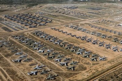 January 10, 2019 AMARG: The US Plane Graveyard Where Aircraft are Stored, Stripped, Repaired, and Restored
The post What Happens to the Olympic Venues in the Host Countries After the Olympic Games End? appeared first on .
]]>The post Kuldhara, the Abandoned Village of an Aggrieved Indian Community appeared first on .
]]>
Kuldhara village, Rajasthan. (Suryansh Singh / Wikimedia Commons)
Rajasthan, the Indian state with desert land, scrub forests, high rocks and hills, is also the land of the esoteric and the paranormal. Its folklores are flush with stories about ghosts and how the spirits live on to wreak vengeance, even after the physical body dies. Kuldhara, a village in Jaisalmer district is one such story. A prosperous community of this village was forced to leave their village. They did it under duress, with a heavy heart.
History of Kuldhara
The incident happened in 1825. Kuldhara was a stronghold of Paliwal Brahmins who had made their mark in business and agriculture. Even in water-scarce of desert land, they grew wheat and other water-intensive crops. They were good animal raisers and did business with Sindh (now in Pakistan) and other countries through the old silk route. They traded in food grains, poppy, indigo, ivory, and dry fruits on camel back. All was going hunky dory for the community till the Diwan of Jaisalmer, Salim Singh, came on the scene. He was Diwan of Jaisalmer, and a corrupted one. His lecherous gaze fell on the daughter of the village chief. The chief must marry his daughter to him; else face disastrous consequences, by way of punitive taxes.
For Paliwal Brahmins, it was a second major migration
The village chief had a Hobson’s choice. Marry his daughter to a debauch, or suffer a crushing tax burden. A council was held. The council of Kuldhara and neighbouring villages ruled that their daughter wouldn’t be given to a lout who already had 7 wives. Nor would they accept the taxes. They would rather move out with whatever they can carry easily. This was a second such crisis for the community. First happened at their erstwhile abode in Pali, Jodhpur. The king of Jodhpur, envious of their prosperity, increased their tax burden inordinately. That had forced their first migration. Now was the time for the second migration. Their tumultuous history was repeating itself.

Remains of houses in Kuldhara village. (Archan dave / Wikimedia Commons)
They left their homes and cursed village to remain deserted forever
So, on a dark night, there was a mass exodus of about over 1500 people from Kuldhara and adjoining 85 villages. They left their homes, and most of their belongings, and walked out in the wilderness. So discreet was the march that it went unnoticed. It is believed that the community moved to Madhya Pradesh, Uttar Pradesh and Maharashtra. But while departing, they cursed the land they left behind. That it will never be populated. And, whosoever will try to settle here, will suffer their curse.
Most villages around Kuldhara, with their names altered, are colonized now. But Kuldhara and partly Khaba (home to Hindus displaced from Pakistan) still remain desolate.
Haunted looks and an eerie ambience
The curse of the oppressed Brahmins of Kuldhara has worked. There is a prevailing belief that whosoever tried settling in Kuldhara, was rattled by paranormal forces. With sunset, the place is closed for visitors. People in the neighbouring areas believe that supernatural forces descend in the village at the night time. The fact is corroborated by investigation of the paranormal society, New Delhi. Weird sounds, spooky shadows, damage to the parked vehicles and more such bizarre incidents occurred with people staying here beyond the day time.
The area is a promising tourist spot
The deserted sandstone houses of village bespeak of good architectural design. The remnants of 600 living homes, temple, wells, water reservoir, water ponds and public places reveal that the community had an aesthetic sense of living. The site is now supervised by the Archaeological Survey of India. Plans are underway for renovations to make this village visitor – friendly and an enjoyable tourist destination.
Enjoyed this article? Also, check out “Dhanushkodi: Where a Cyclone Ripped Apart an Entire South Indian Town, Rendering it Uninhabited“.
Fact Analysis:
STSTW Media strives to deliver accurate information through careful research. However, things can go wrong. If you find the above article inaccurate or biased, please let us know at [email protected].
RELATED
- December 12, 2018 Dhanushkodi: Where a Cyclone Ripped Apart an Entire South Indian Town, Rendering it Uninhabited
 July 15, 2019 Adalaj Stepwell: A 500-Year-Old Architectural Masterpiece With a Tragic Tale of Unrequited Love, Sacrifice And Loss
 May 31, 2019 Chand Baori: A Quaint Remnant of the Past
 November 16, 2018 Water Wives of India: Denganmal in Maharashtra, Where Men Have Multiple Wives to Fetch Water
The post Kuldhara, the Abandoned Village of an Aggrieved Indian Community appeared first on .
]]>The post Prora: Hitler’s Colossal Resort by the Beach That Never Served Its Purpose appeared first on .
]]>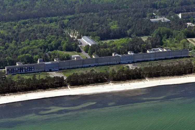
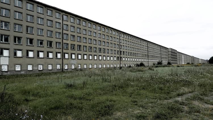
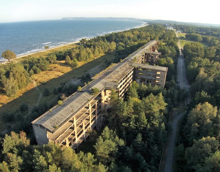
Colossus of Prora. (Klugschnacker / Wikimedia Commons)
Welcome to Prora. Now, you may be wondering as to what is Prora? It is nothing but the largest ever structural relic of Hitler’s fascism. It is a 4.82 km long structure on the shores of Baltic Sea where training was given to Nazi soldiers during the WWII.
After Adolf Hitler declared himself the Führer of Germany in 1933-34 period, there was immense pressure on factory workers to work harder. His dictatorship not only vexed the common people, but also the factory workers across the Fatherland.
Elevation of Prora. (Christoph Stark / Flickr)
Resort complex on the island of Rügen
Sensing trouble brewing among the overworked workers, Hitler ordered the construction of a massive resort complex on the island of Rügen. The island is the largest island of Germany and is located off the Pomeranian coast in the Baltic Sea.
On the orders of Hitler, construction of the monstrous resort complex, known as Prora, began in 1936, three years before the WWII began. With 10,000 rooms, the leisure resort was meant to house at least 20,000 German workers who were to be sent on holiday.
What was interesting about the resort was that it featured a seaward view from each and every room. The rooms were constructed in a bid to offer an inexpensive vacation to the average German worker. This was alleged to be based on the ethos that every German worker deserved a day at the Baltic Sea beach.

Bird’s-eye view. (stephane333 / Flickr)
The architecture of the Prora resort did not represent the Weimar Republic’s colourful style. In fact, it appeared more like a chilling but aesthetic machine.
It is really strange that one of Fuhrer was a believer in vacation time for overworked workers.
The ‘Strength Through Joy’ (Kraft durch Freude), a Nazi leisure organisation, was behind the construction of the Colossus of Prora. Robert Ley’s German Labour Front is said to have operated the Kraft durch Freude.
Hitler’s idea
On the surface, Hitler’s idea behind Prora was to incentivise common German people to support him. But, he had darker ideas. The Führer was planning to use the beachside resort for military installations. Sadly though, the project came to a halt after Hitler invaded Poland in 1939 only to trigger the WWII.
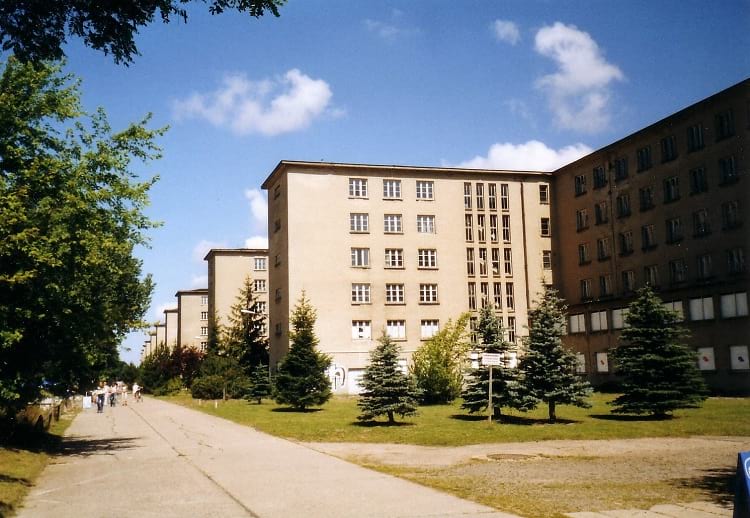
The start of WWII left the 10,000 rooms and a huge theatre empty. The swimming pools went dry. Decades later, WWII refugees were briefly housed at Prora. The rooms were also used as a home for the elderly for other short term uses.
View from the land-side. (Steffen Löwe / Wikimedia Commons)
Prora buildings remained deserted
Otherwise, for most of the period up to the 1990’s the Prora buildings remained deserted. Even today, quite a few building stand empty. During the late 1990s, the first civilian use of Prora was as a YMCA. However, some rooms are being used as a gallery space and a museum.
Recently, the German government renovated the YMCA youth. However, several other blocks of buildings were sold to various developers. Some of the buildings that have been sold are being renovated now.
Bid to purge the checkered beginnings of Prora
In recent years, however, the German government has been making attempts to convert some buildings at Prora into luxury condos. Thus, the government is attempting to purge the checkered beginnings of Prora.
This is unusual, as the German government generally deals with the Third Reich heritage in a delicate manner.
According to Katja Lucke, an employee at the Prora Documentation Centre, a study is said to have proposed to the government to use Prora for soft tourism and education. However, the government realized that it was a complex task. Therefore, it decided to sell portions of the property to avoid taking further responsibility.
The incomplete portion of the complex. (Aviorausch / Wikimedia Commons)
Prora was sold off
Prora was sold off piece by piece without involving the local government. Interestingly, the German government declared the Prora buildings a heritage monument. All such monuments attract subsidies in Germany.
Most of the flats in the buildings have been sold since 2016 as they are aimed at a typical German luxury clientele.

Prora Solitaire Apartments, a renovated section of the enormous complex. (Judith Richmann / Wikimedia Commons)
Widespread opposition
At a time when the government is trying to reconstruct the building to create something new for the future generations, there is widespread opposition locally and otherwise. This is giving rise to Nazi ideas.
In the recent past, when elections were held, poll posters sprung up urging people to vote for the Alternative für Deutschland (AfD). It is a party that appeals for hostility against foreigners. It also wants an end to interrogations on Third Reich actions. Interestingly, AfD’s vote share jumped sharply on the depopulated island of Rügen.
Interestingly, after 80 years, the unity of Prora buildings, which symbolize the greed of power of the fallen Third Reich, cannot be preserved any longer.
Enjoyed this article? Also, check out “Schwerer Gustav: Why the Largest Artillery Gun Turned Out to Be a Flop During World War II?“.
Fact Analysis:
STSTW Media strives to deliver accurate information through careful research. However, things can go wrong. If you find the above article inaccurate or biased, please let us know at [email protected].
RELATED
- September 11, 2019 Maginot Line: The Mark of French Tenacity and Resilience
 May 21, 2019 Hindenburg: The Tragic Death of World’s Biggest Commercial Airships
 August 16, 2019 Schwerer Gustav: Why the Largest Artillery Gun Turned Out to Be a Flop During World War II?
- June 22, 2019 Rape of Nanking is One of the Most Brutal and Forgotten Genocides of 20th Century
The post Prora: Hitler’s Colossal Resort by the Beach That Never Served Its Purpose appeared first on .
]]>The post The Disappearing Aral Sea and its Abandoned Ships appeared first on .
]]>
Aral sea, Mo’ynoq. (Land Rover MENA / Flickr)
Russia, then, was the undivided Soviet Union. The state government thought rivers which fed the Aral Sea (actually a lake, derived from prehistoric ‘sea’ cut short by tectonic shifts on earth surface) could be syphoned to support agriculture crops in the desert land of Central Asia. The idea worked for a short time, then nosedived, demolishing geography and demography of the area to the point of no return. A typical case of nature’s fury in the face of human misadventure.
Tapping rivers for agriculture took the toll on the terminal lake (sea)

The Soviet irrigation project of cotton cultivation, 1960s. (David Stanley / Flickr)
Indeed, in 1960, the government action appeared a benign idea towards the welfare of the Russian people. The Amu Darya and the Syr Darya, the two rivers feeding Aral Sea (lake), were channelled into infertile plains of Kazakhstan, Uzbekistan, and Turkmenistan, to grow agriculture crops.
Come 1980, and Uzbekistan became the largest producer of cotton, but the Aral Sea shrunk in size. Reduced input of water from the feeding rivers wasn’t enough to compensate for the loss of water by evaporation in the arid conditions.
By 2000, Aral Sea was reduced to a minuscule of its 1960 size and split into 2 halves: the small Aral Sea, and the large Aral Sea. By 2001, the 2 parts, connected precariously, got completely detached. Drought conditions depleted the Amu Darya and stopped its flow altogether. In 2014, a big chunk of the large Aral Sea was lost to desert sand.

Aral sea in the year 1989 (left) and in the year 2014 (right). (NASA. Collage by Producercunningham / Wikimedia Commons)
The drying Aral Sea changed the climate and the demography unfavourably
Drying of the Aral Sea ruined fishing business, uprooting the stakeholders and forcing them to migrate for new business/employment. The salt content of the lake increased as the surface water evaporated fast. The fertilizers and pesticides used in nearby crops found their way into the lake. Winds lashing the lake bed got laced with salt and chemicals and contaminated the region’s ecosystem. Summers and winters became unusually harsh as a moderating influence of water disappeared with the dying lake. Standing crops required surplus irrigation to flush out harmful chemicals; that jacked up the rate of water depletion in the region.
Waterbody changed to a graveyard of boats
Indeed, drying of the Aral Sea is a typical case of irreversible man-made disaster. It transfigured one of the 4th largest lakes in the world into the desert sand. Most of the heydays working ships now lie thrashed on the lake bed, stripped of their saleable parts. The ship graveyard in Moynaq, Uzbekistan is a poignant reminder of what once used to be a roaring Aral Sea.


Abandoned ships at Aral sea. (Arian Zwegers / Flickr)
Market-driven economy post disintegration of USSR added to the woes
With the disintegration of Soviet Russia in 1991, subsidies and safety nets of a centralized government came to an end and the emergent independent republics were forced into a market-driven-economy. This added to the hardships which the shrinking Aral Sea had already precipitated. Indeed, the circumstances were propitious for a war-over-water in the Central Asia region.
Damage control was too little and too late
Belatedly, the government of the day rose to the challenge of the vanishing lake. The Republic of Kazakhstan built the Kokaral dam in 2005. This reversed the trend of water depletion and gave a fillip to the fishing business. By 2008, Syr Darya water was well under state control. This resulted in the revival of the small Aral Sea to the extent of 68%. The salinity of the lake too was reduced to half.
The larger Sea (on Uzbekistan side) though, couldn’t be revived. The Republic of Uzbekistan showed more interest in growing cotton than spare water for this part of the lake. The lake got decimated all the more when Lukoil, the Russian oil company, drilled it for oil and gas in 2006.
War on water became a reality
With water resources pushed and shoved, the neighbouring countries were bound to feel hard up. Cotton farmers of Uzbekistan felt threatened by the establishment of the hydroelectric power plant in Kyrgyzstan. This flared up border skirmishes between the two nations. The strategic holding of water by Kyrgyzstan in 2013 choked the water supply in 11 regions of Uzbekistan, and the acrimony between the two republics was an all-time high. Salty winds blew from the vanishing sea all this while, endangering public health no end.
Biological weapons programme was another highlight of the region
A spooky dimension to the eco tragedy is added by the secret experiments in biological warfare. Vozrozhdeniya, an island in the Aral Sea, was the site for the biological weapon’s program of the Soviet Union. It is believed that fully or partially developed biological weapons lie buried there. The island, buffered by a huge body of water and desert sand was an ideal place to culture dangerous microbes like anthrax, typhoid, plague and tularemia and turn them into weapons of mass destruction. The site is now an unrestricted area where anyone can walk in freely.
Messing with nature is no commerce
Irreversible climatic changes in Central Asia testify to the error Soviet Union made in messing with the path of rivers falling in the Aral Sea. Obviously, if society can react to stress imposed on it by the environment, the environment too can react to stress imposed on it by human society. Unfortunately, nature’s reaction, as in this case, maybe too hard to be moderated or reversed.
Enjoyed this article? Also, check out “Euphrates River: A Dying River that Birthed One of the Oldest Civilisations“.
Fact Analysis:
STSTW Media strives to deliver accurate information through careful research. However, things can go wrong. If you find the above article inaccurate or biased, please let us know at [email protected].
RELATED
- December 12, 2018 Dhanushkodi: Where a Cyclone Ripped Apart an Entire South Indian Town, Rendering it Uninhabited
 December 30, 2018 Lake Reschen: Italy’s Submerged Lake Reschen
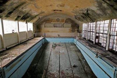 May 2, 2019 What Happens to the Olympic Venues in the Host Countries After the Olympic Games End?
- February 18, 2019 The Ryugyong Hotel of North Korea: The Tallest Unoccupied Building in the World
The post The Disappearing Aral Sea and its Abandoned Ships appeared first on .
]]>The post Duga Radar: Unravelling of the Mystery Behind the Soviet Woodpecker appeared first on .
]]>
Duga radar, Ukraine. (Олег Михайлович / Wikimedia Commons)
The mystery shrouding the Duga Radar, nicknamed Woodpecker, is slowly getting unravelled. Thirty-two years after the world’s worst nuclear disaster at Chernobyl in the former USSR, the Ukrainians are permitting visitors to the facility. The Soviet Union gave the radar system the code 5Н32-West. The Duga appears like an iron curtain in the middle of a forest. Similar to a network of massive radar antennas, it stands tall inside the off-limits military zone in Ukraine.
Duga means arc in Russian. The radar was part of USSR’s anti-missile and anti-space defense system. Its main purpose was to allow the Soviets to detect any ballistic missile attacks from the NATO members, including the Americans. The Soviets could detect a ballistic missile movement within three minutes of its launch.
The over-the-horizon (OTH) radar system that was used as a part of the Soviet missile defense early-warning radar network measured 150 meters (492 feet) high and 700 meters in length. Hidden in the forests near Chernobyl, it was abandoned after the nuclear disaster on April 26, 1986, that sent a wave of radiation across Europe.

Tourists visiting Duga radar. (spoilt.exile / Flickr)
History of Duga Radar

Duga radar. (Hnapel / Wikimedia Commons)
The construction of Duga radar began in 1972 and it became operational in 1976. That was the time when tensions were high between the Soviets and the NATO allies due to heightened Cold War conditions.
During such times, scientists in the USSR were trying to find ways to lessen threats of long-range missiles. They came up with the idea of constructing a massive over-the-horizon-radar with the intention of bouncing signals off the ionosphere and gaze towards North America.
Duga radar, also known as Chernobyl-2, was given a fake identity. Soviet maps marked the facility as a camp for children. A bizarre bus stop erected on the road to the facility showcased a bear mascot from the 1980 Moscow Summer Olympics.
According to legend, Ukrainian tour officials are said to have told the first set of visitors, who were granted access to Chernobyl in 2013, that Duga was an unfinished hotel.
Over-the-horizon
When Duga radar became operational in 1976, it detected the exhaust flames of missiles that were launched. It could do this with the help of short radio waves that were capable of traveling over 3,000 km with the help of a technique called ‘over-the-horizon’ radiolocation.
In 1976, the world first heard these waves in the form of creepy and repetitive pulses that came out of the Chernobyl-2 transmitters, located 60 km from the Duga radar in Lubech-1 town. The town is now abandoned inside the Chernobyl Exclusion Zone. Interestingly, the Duga radar was just a signal receiver.
The radar systems were very powerful. Sometimes coming over 10 MW, they appeared without warning with a sharp and repetitive tapping noise in the range of 10 Hz. The short wave listeners, therefore, nicknamed it as the Russian Woodpecker.
The repetitive frequency hops caused disruptions to legitimate broadcasts like oceanic commercial aviation communications, amateur radio operations, and utility transmissions. There were thousands of complaints worldwide as the signal was causing a nuisance to receivers.
The amateur radio operators started filtering out the interference with ‘Woodpecker Blankers’ by making minor changes in the circuit designs. This led NATO’s military intelligence to name Duga radar as the Steel Yard.
Wild speculations
Pavlo Fedykovych of CNN writes in his article that the radar facility located within the peaceful untouched forest near Kiev, Ukraine’s capital, is a closely guarded Cold War secret that is mysterious and sinister in nature.
For decades, the Duga facility continuous to pose questions that gives no answers. People still do not understand its real purpose.
During the facility’s peak period, western media made wild speculations and published reports on conspiracy theories. They claimed that the Soviets were trying to control the minds of the allies. They also claimed that these low-frequency “Russian ‘woodpecker’ signals” could destroy human brain cells and or control human behaviour.
Disappearance
In this background, the United States Federal Communications Commission (FCC) held a study in 1988 on the ‘Woodpecker’ signals. FCC’s data analysis indicated that the signals were having an inter-pulse period of 90 ms. The frequency range was 7 to 19 MHz and a bandwidth of 0.02 to 0.8 MHz. The study found that a typical transmission time was 7 minutes.
Following the study, the FCC began publishing guidelines. But surprisingly, the signals became less frequent. By 1989, the signals totally disappeared signaling the end of the Cold War.
USSR ghosts
On April 26, 1986, there was an explosion at the nuclear facility at Chernobyl. That was the end of the Duga radar facility due to radiation contamination. With this, most of Duga’s top-secret documents were either destroyed or archived in Moscow.
Further, there was chaos after the Soviet Union collapsed and the radar’s fate was sealed off from the public view till now. After the Chernobyl catastrophe, the Soviet Union vanished, but its ghosts are still haunting Ukraine.
Enjoyed this article? Also, check out “Pripyat, Ukraine: The Thriving Soviet Nuclear City That the Chernobyl Disaster Turned into a Ghost Town Overnight“.
Fact Analysis:
STSTW Media strives to deliver accurate information through careful research. However, things can go wrong. If you find the above article inaccurate or biased, please let us know at [email protected]
RELATED
- January 25, 2019 Pripyat, Ukraine: The Thriving Soviet Nuclear City That the Chernobyl Disaster Turned into a Ghost Town Overnight
 May 27, 2020 Bartini Beriev VVA-14: The Cold War Scramble for Arms Gave Birth to an Amphibian Aircraft in Russia
 October 24, 2019 Why Were the Apollo 11 Astronauts Quarantined after Returning from the Moon?
- March 26, 2019 The Disappearing Aral Sea and its Abandoned Ships
The post Duga Radar: Unravelling of the Mystery Behind the Soviet Woodpecker appeared first on .
]]>The post The Ryugyong Hotel of North Korea: The Tallest Unoccupied Building in the World appeared first on .
]]>
Ryugyong Hotel. (Roman Harak / Flickr)
With 105 stories and a height of 1080 feet, the Ryugyong Hotel in Pyongyang in North Korea is the 63rd tallest edifice ever built as of 2019. At present, it also happens to be the world’s tallest, unoccupied building. This status may change with a shift in political winds and with an inflow of new foreign investment into North Korea.
The world’s tallest hotel

Portrait of Kim Il-Sung. (Gilad Rom / Wikimedia Commons)
In 1987, on the instruction of the then President of North Korea, Kim Il-Sung, the North Koreans commenced building what was to be the tallest hotel in the world. The plan was to surpass the very tall Westin Stamford Hotel that the South Korean company SsangYong Group had built in Singapore in 1986.
The North Koreans also wanted to outshine the international limelight that would come South Korea’s way for hosting the 1988 Seoul Olympics. It would be a great worldwide sensation if they opened the Ryugyong Hotel with the commencement ceremonies of the 13th World Festival of Youth and Students that they were hosting in June 1989.
Along with publicizing the achievements of the North Koreans, the world’s tallest hotel would, hopefully, also bring in direct foreign investment by attracting tourists and foreign investors. Hoping to bring in at least $230 million in foreign investment, the North Korean government set up the Ryugyong Hotel Investment and Management company. They promised many concessions to would-be foreign investors, including the right to operate nightclubs, lounges, and casinos in the towering hotel.

Ryugyong Hotel in 2012. (Jen Morgan / Flickr)
Building the Ryugyong Hotel
Baikdoosan Architects & Engineers, a North Korean construction firm, come up with a unique pyramidical design for the new hotel and began construction work on it in 1987.
They built a three-winged building with all the wings converging together into a pinnacle. Each of these wings has a length of 330 feet, a width of 59 feet, and a sloping angle of 75 degrees. There are 3000 or 7665 rooms for guests. At the top of the building, there is a short cone that has a width of 130 feet, eight revolving floors, and six stationery floors above these.
Until 2009, when Dubai’s Rose Tower raised its spire over its already 984 feet height and thereby surpassed the Ryugyong Hotel’s height, the latter had the distinction of being the world’s tallest hotel building.
Financial problems
Building material shortage and work delays prevented the scheduled opening of the Ryugyong Hotel during the opening of the 13th World Festival of Youth and Students in June 1989
If they had been able to finish the work on schedule, the Ryugyong Hotel would have become the world’s seventh highest building, surpassing the Westin Stamford Hotel’s 741 feet; the latter, at the time, was the highest hotel in the world.
With the dissolution of the USSR in the 1990s, North Korea lost its most important backer and funder. It was no longer financially sustainable for the country to continue the construction work at Ryugyong Hotel. They had already spent around two percent of the country’s GDP, an estimated $750 million, on the hotel and now they had simply run out of ready money for further work.
By the time the work stopped, the builders had finished constructing the full size of the building. The incomplete structure loomed against the sky as it was, without fixtures and fittings, for the next 16 years. The builders had left a construction crane at the very top of the structure and it rusted there, poignantly reminding everyone of “the totalitarian state’s thwarted ambition,” at least according to the UK’s propaganda arm, the BBC. Other Western mainstream media outlets took the lead in dubbing the unfinished building as “The Hotel of Doom,” “The Phantom Hotel,” and “The Worst Building in the World.”
In North Korea, where the government had commemorated the hotel by printing its image on their national stamps, the media took care to make no further mention of the hotel. Although the building remained prominent on the city skyline, the government directed that its presence be excised from the map of Pyongyang and from official photographs of the city.
Construction issues
According to some sources, the concrete used to build the hotel was of inferior quality and this means that the construction is unsound. There have also been rumours that the lift shafts are not correctly aligned.
Resuming the construction of Ryugyong Hotel
In April 2008, the Egyptian company, Orascom Group, stepped in to help with continuing the hotel’s construction. They added a telecommunications antenna and the glass cladding over the entire exterior of the building that gave it the current shiny appearance.

Ryugyong Hotel without the cladding. (Chris Price / Flickr)
According to Khaled Bichara, the Chief Operating Officer of the Orascom Group, the Ryugyong is no longer to be only a hotel, but a building for mixed-use purposes. It will have restaurants, hotel accommodation, apartments, and business facilities. He also stated that the building did not have “too many problems” on the structural front, at least nothing that the Orascom Group couldn’t resolve.
By July 2011, the Orascom Group finished the hotel exterior. The following year, in September of 2012, Koryo Tours released photographs of the partially finished interior.
The Kempinski Hotels Group, in November 2012, announced their intention to run the hotel after its expectant opening in 2013. This opening plan fell through and the Kempinski Hotels Group backtracked on their earlier statement, saying they hadn’t signed a definitive agreement to run the hotel. It is possible that the ongoing hostility of the United States and other Western countries towards North Korea had something to do with in this backtracking decision.
Current status of the Ryugyong Hotel
After a hiatus of a couple of years, the Orascom Group resumed work on the Ryugyong Hotel in 2016 and are reportedly still working on it. They built access roads to the hotel in 2018 and added LED display features on the building exterior. The building now lights up every night with a light display featuring the North Korean flag and encouraging slogans.
In early 2019, the Ryugyong Hotel still stands vacant and retains its Guinness World Records title of being the tallest, unoccupied building in the world. This may change in the future, once the Orascom Group finishes their work.
Enjoyed this article? Also, check out “Varosha: The Abandoned Luxury Retreat in the Mediterranean“.
Fact Analysis:
STSTW Media strives to deliver accurate information through careful research. However, things can go wrong. If you find the above article inaccurate or biased, please let us know at [email protected].
RELATED
- May 2, 2019 What Happens to the Olympic Venues in the Host Countries After the Olympic Games End?
- December 12, 2018 Dhanushkodi: Where a Cyclone Ripped Apart an Entire South Indian Town, Rendering it Uninhabited
- March 26, 2019 The Disappearing Aral Sea and its Abandoned Ships
 July 23, 2018 Nauru: An 8 Square Mile Island That was Once the World’s Richest Country
The post The Ryugyong Hotel of North Korea: The Tallest Unoccupied Building in the World appeared first on .
]]>The post Kolmanskop: From Being the Richest Town to Now Being Devoured by the Desert appeared first on .
]]>
Inside an abandoned house in Kolmanskop. (Michiel Van Balen / Flickr)
Kolmanskop is the name of a railway station in Namibia (Southern Africa). It lies 850 km south-west from Windhoek – the capital city of Namibia, and 10 km from a secluded seaside town called Lüderitz. The station is named after a man called Johnny Coleman. This man, a transport driver, was stranded in a severe sand storm along with his ox wagon and died of extreme thirst in the hot desert. In his memory, the station was named Kolmaskop. `Coleman’s hill’ in Afrikaans is called Kolmanskop, hence the name. It is called ‘Kolmannskuppe’ in the German language. The station, in course of time, became the hub of a diamond industry of world fame.

Kolmannskuppe signboard. (Zairon / Wikimedia Commons)
Discovering diamonds in Kolmanskop, Namibia
Circa 1908, following official orders to keep the Kolmanskop railway line clean, a railway worker picks up a sparkling stone from the track and takes it to his boss. August Stauch, the boss, a mineralogist by hobby, was impressed with the finding. It surely wasn’t an ordinary stone. He showed it to Sonke Nissen, his friend and a Mining Engineer. It was a diamond. Great news indeed, but they must keep it to themselves, to make the most of it. They do just that and keep the finding a closely guarded secret. They quit their jobs and acquire 75 acres of land at Kolmanskop, between Luderitz and Keematshoop. With fond dreams of digging diamonds, and living happily ever after, they settle down in their new venture.
Diamond transformed a sleepy habitation into a rich township
A secret as precious as a diamond, obviously, couldn’t hold for long. Soon, it was out in the public domain and the diamond seekers swarmed the area. In a matter of 23 years, the place got transformed into a vibrant township, the world’s richest. With a population of just 400 people, the town, in 1911, boasted of electric power, school, hospital and casino. It also had a theatre, sports hall, ballroom and swimming pool. An ice factory was set up to supply ice for the fridge in households. The town had a functioning post office, bakery and shops for all kinds of provisions. The hospital, notably, had an x-ray machine, the first ever to be installed in South Africa. Apart from medical use, the machine helped to fix workers who tried stealing diamonds by swallowing them.
The government taking notice of the diamond business
In time, the state administration woke up to the diamond loot and banned possession of land in Kolmanskop for private use. The Railway Station was declared a restricted diamond area. A well-organized industry came up in the region, to separate diamond from sand. Cape Town was unlucky to have missed this industry all because of a bad decision. The desert region of kolmanskop was offered to Cape Town administration in 1885, but the Cape government, then, had declined the offer.
World War came as a spoiler for the diamond industry
The diligence that went into separating diamonds from the sand was enormous. This can be gauged from the fact that processing 10 tons of sand yielded just one or two carats of diamonds. Yet, up to 1914, a massive amount, 1 ton of diamond, was extracted. As world war broke out the same year, the diamond industry came to a grinding halt. The Germans, having a major engagement with the diamond industry, fled the area. Thereafter, Kolmanskop came under the direct administrative control of South Africa.

Kolmanskop, Namibia. (Johan Jönsson / Wikimedia Commons)
Intensive mining exhausted one resource, forcing search for another
With the depletion of diamond reserves around the Railway Station, the mining activity had to be moved to the contiguous distant areas. Prospective mining areas were found in the south of Luderitz, and up to Oranjemund town at the mouth of river Oranje, near the South African border. In a decade’s time, the diamond industry shifted completely to the South and the 1914 setup was trashed. With all inhabitants quitting Kolmanskop by 1960, the only vacant building remained, to be dishevelled and engulfed by the surrounding desert.
The evacuation of the town was hastened by the discovery of upscale diamond deposits in 1928. These deposits were on beach terraces close to the river ‘Oranje’. People rushed 270 km south of Kolmanskop to grab the precious bounty. In the process, all settlements in the region were uprooted. For some time, Kolmanskop served as a supply depot for the mining operations at the far-away diamond deposits. But subsequently the supplies got sourced from South Africa and connections with Kolmanskop were severed for good.
As the diamond industry shifted base, ruins of Kolmanskop became a tourist hub
The shift of the diamond industry to Luderitz brought immense riches to this town. At the same time curiosity about Kolmanskop, the Railway Station where the story began in 1908, increased by the day. Some tourists went to the deserted township of the diamond industry and explored the derelict buildings lying in sand mounds.

A house engulfed by sand dune. (Sonse / Wikimedia Commons)
The abandoned homes and buildings were dug out, repaired and renovated. These were typical German architecture with large windows and curtailed roofs. The curiosity soon became business and Kolmanskop came back to life in a new avatar – a tourist destination. The risen-from-sands township is now an organized vacationer, guiding visitors in multiple languages: English, German and Afrikaans. Tours operate twice daily from Monday to Saturday. On Sundays, only one tour is conducted.

Aerial photo of Kolmanskop. (SkyPixels / Wikimedia Commons)
Déjà vu Kolmanskop
The desert sand blows through the day and only scant vegetation grow in Kolmanskop region. Yet in its heydays, gardens with eucalyptus trees, lawns and flowers were kept and maintained by the township. Freshwater was brought in through railway tankers and stored for irrigation as well as human consumption. The harsh desert conditions discouraged keeping of pets. But the story of one pet ostrich is very much on record. The bird was generally hostile to people but drew cheers on Christmas Eve when it pulled at celebratory sledge on sand mounds.

Kolmanskop. (calliopejen1 / Flickr)
Like diamonds are forever, Kolmanskop remains in the reckoning even in doom.
Enjoyed this article? Also, check out “Hashima Island: A Once Bustling Japanese Metropolis That Now Reminisces Its Hauntingly Tragic Past“.
Fact Analysis:
STSTW Media strives to deliver accurate information through careful research. However, things can go wrong. If you find the above article inaccurate or biased, please let us know at [email protected].
RELATED
- July 2, 2019 Varosha: The Abandoned Luxury Retreat in the Mediterranean
- January 25, 2019 Pripyat, Ukraine: The Thriving Soviet Nuclear City That the Chernobyl Disaster Turned into a Ghost Town Overnight
- February 13, 2020 Hashima Island: A Once Bustling Japanese Metropolis That Now Reminisces Its Hauntingly Tragic Past
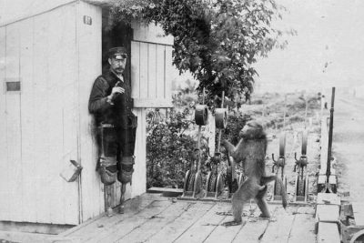 December 25, 2018 Jack the Baboon Once Served as a Railway Employee for 9 Years and Didn’t Commit a Single Mistake
The post Kolmanskop: From Being the Richest Town to Now Being Devoured by the Desert appeared first on .
]]>The post Al ’Ula Town: A Once-Flourishing Oasis That Now Lies in Dust, Hidden from the World appeared first on .
]]>
Al `Ula, Kingdom of Saudi Arabia. (Pteropus conspicillatus / Wikimedia Commons)
Nestled quietly in the western part of the Kingdom of Saudi Arabia, the ruins of Al ’Ula seem to come straight out of an ancient civilization. With mud, brick and stone houses, closely arranged together against the blue skies, flanked by mountains on one side and effects of modernisation on the other, Al ’Ula is one lost town that the world has conveniently forgotten. Located approximately 400 kilometres north of the holy city of Medina, the town of Al ’Ula was once a flourishing city that presented a perfect picture of fine Arab architecture. Founded in the sixth century BC, the two-thousand-year-old town is located on the historic Incense Route, which facilitated trade of spices, fragrances, silk and other items of luxury between Saudi Arabia, India, Egypt and the Mediterranean regions.
History of the town of Al ’Ula
An oasis right in the middle of the desert, Al ’Ula had plenty of water and arable land back in time, where humans first started to settle down during the Bronze Age. The Arabian Peninsula is close to a million years old and with Al ’Ula’s regular supply of water, human habitation may have been constant in the valley through the eras. Ancient human carvings and murals dating back to the Bronze Age that flourished in the third and second millennia BCE prove that the old town existed when nothing else did. But unlike other historical sites including Rajajil and Shuwaymis, which were abandoned immediately after continuous periods of draughts set in, Al ’Ula managed to thrive in the harshest of temperatures. A regular supply of underground water system helped the population in the city to prosper for a very long time until the last family is said to have moved out of the town in the year 1983.

Abandoned mud houses of Al ’Ula. (Sammy Six / Flickr)
The religious significance of Al ’Ula
In the year 630 CE, when rumours spread across the world that there would be a Byzantine invasion (also known as the spread of the Roman Empire) in Arabia, the Islamic prophet Mohammed led a military campaign against the western rule. With as many as thirty thousand forces, he travelled towards modern-day Tabuk in northwest Saudi Arabia to face the Roman army. He, along with his forces, passed through the old town of Al ’Ula, where they are said to have halted for three full days and upon seeing no sign of the approaching Roman army, retreated to Medina, thus giving the city a religious connotation.
Al ’Ula as an ancient pilgrimage city
Cashing in on from the water supply of the oasis, the city quickly became a commercial centre and merchants, travellers and caravans started halting for trade in the town. The valley of Al ’Ula, also mentioned as Wadi Al-Qura in Islamic texts, soon became a place of Muslim occupation. On their route to the holy city of Mecca from the Syrian capital of Damascus, pilgrims stopped by in the town of Al ’Ula to buy provisions for their long journey ahead. Later, some of them also started leaving behind their possessions at Al ’Ula, which they would retrieve once they got back. Syrian businessmen are also said to have travelled all the way from their home town to Wadi Al-Qura to sell their supplies to pilgrims, en route Mecca.

Al ’Ula today. (Sammy Six / Flickr)
Life in Al ’Ula back in time
A fortified area, Al ’Ula is still packed with mud and stone houses and was once a capital of the Lihyan Kingdom that ruled over Arabia for a very long time. Apart from the ancient kingdom of Lihyan, the Arab Nabataeans and more recently, the Ottoman Turks ruled over the old city, thus marking its significance in the course of human history. Greeks and Romans, too, are said to have passed through this old town, leaving their mark on people’s lifestyle, as also on the few odd buildings that still stand tall, while on their way to conquer the world. Dotted with mud houses, the narrow alleyways of Al ’Ula always bustled with people and a whole lot of colours back in the day. The houses were tightly packed like mazes in a honeycomb. Farmers sold their produce on donkey backs in the small plazas and life in the old town was always busy.
With more and more civilizations coming in, a lot changed in Al ’Ula over the centuries. The Ottomans built a railway network, linking it to Damascus and more recently, town centres were established during the turn of the modern century. Slowly, people started deserting the old by lanes of Al ’Ula for a better life in the city and the town of Al ’Ula lay all alone in shambles with nothing but muddy houses that could blow away with a strong gust of wind and some stone structures that speak of the ancient people’s architectural expertise.
World Heritage Site in Al ’Ula
As human settlements came and went in the old town of Al ’Ula, one that left an indelible mark, bringing fame to the Islamic country is Madain Saleh, which is also Saudi Arabia’s first ever UNESCO World Heritage Site (named in 2008). Also known as Al-Hijr, it is spread across a sprawling 52 hectare of land and is made up of well-conserved, colossal tombs that are more than a hundred and twenty in number. The intricate and complex facades cut out of solid rocks belonging to the Nabataean period, make it a place of historical, religious, cultural as well as archaeological importance.

Madain Saleh. (Richard.hargas / Wikimedia Commons)
The government of Saudi Arabia has initiated to undertake efforts to bring the old town back to life to boost tourism in the region; but the ghost town of Al ’Ula will remain in secrecy, waiting till the dust finally lifts off from a bygone era, thousands of years old.
Enjoyed this article? Also, check out “Hashima Island: A Once Bustling Japanese Metropolis That Now Reminisces Its Hauntingly Tragic Past“.
Fact Analysis:
STSTW Media strives to deliver accurate information through careful research. However, things can go wrong. If you find the above article inaccurate or biased, please let us know at [email protected].
RELATED
 August 2, 2019 Vast Oil Reserves Buried Under Rub’ al Khali the Largest Sand Desert in the World
- February 18, 2019 The Ryugyong Hotel of North Korea: The Tallest Unoccupied Building in the World
- November 9, 2020 Six Flags New Orleans: The Theme Park That Was Abandoned after Hurricane Katrina
- July 2, 2019 Varosha: The Abandoned Luxury Retreat in the Mediterranean
The post Al ’Ula Town: A Once-Flourishing Oasis That Now Lies in Dust, Hidden from the World appeared first on .
]]>The post Pripyat, Ukraine: The Thriving Soviet Nuclear City That the Chernobyl Disaster Turned into a Ghost Town Overnight appeared first on .
]]>
Pripyat, Ukraine. (Jorge Franganillo / Flickr)
Well-known as the city that evacuated the day after the Chernobyl Disaster, Pripyat is now a ghost town in northern Ukraine, near the Belarus border. It is a place where nobody lives anymore, and which nature is slowly but surely taking over. One day soon, all its buildings might collapse, and the forest may grow over the remains.
The City of Pripyat, Ukraine
The Soviet government founded Pripyat on 4 February 1970 to house the workers and the scientists that arrived to work at the Chernobyl Nuclear Power Plant some 180 km from Kiev. Pripyat, which got its name from the nearby Pripyat river, was billed as the Soviet Union’s ninth nuclear city or atomograd and, by 1979, it was home to over 49,000 people of 27 nationalities. Demographic–wise, it was a young city, with most of its residents being in their early to mid-twenties.

Pripyat welcome sign. (Jorge Franganillo / Flickr)
It was a beautiful and vibrant city too, with over a hundred buildings and residences. There were several schools, playgrounds, stores, malls, restaurants, cafes, a cinema, a cultural centre, and a park. The city had stadiums, swimming pools, and gyms. There were factories, a railway station, a bus station, a car park, and a river pier.

A public pool. (Jorge Franganillo / Flickr)
If some people thought that the city was too close to the nuclear plant, it didn’t spread too much concern or alarm amongst the city folks. At the time, everyone considered the nuclear plant to be perfectly safe, a great feat of Soviet engineering that was using nuclear power to generate electricity only for the good and betterment of mankind.

An abandoned amusement park in Pripyat. (Clay Gilliland / Flickr)
The Chernobyl explosion
The very curious thing about the Chernobyl explosion is that it occurred not because of a lack of implementation of essential safety methods, but, quite the contrary, on account of a safety test taken too far.
During the midnight shift on 26 April 1986, the Chernobyl plant was shut down for scheduled maintenance and the nuclear plant’s employees used this opportunity to test the grid systems that kept the core of the reactor cool. They wanted to find out how the grid system would fare if the power went out and the emergency cooling system became inoperable. Would they still have enough electricity for the unit to continue working? Would the reactor still receive enough cooling water? To find out, they turned off the cooling system. If the test went as planned, inertia-generated electricity from the plant’s electric turbines was to have worked the cooling water pumps for about 45 seconds before the three backup diesel generators kicked in and gained the power required to operate the main pump.
As we know, the test did not go as planned. There was an appalling lack of communication between the operators conducting this test. The operators who were going off shift did not adequately brief the operators replacing them, possibly expecting deputy chief engineer Anatoli Dyatlov to have a firm grasp on things as was his wont. The new operators, in turn, were too much in awe of him to express the quibbles they experienced regarding the plant’s reaction as they continued with the test.

Chernobyl Nuclear Power Plant. (Vadim Mouchkin / IAEA)
As the turbines slowed, the cooling water pumps slowed the water flow and steam bubbles formed in the core. These caused the RBMK reactor to embark on a positive feedback loop. The steam bubbles prevented the coolant from absorbing neutrons and this increased the reactor’s output, producing more steam and more power. To counteract this and limit the power, the automatic control system began inserting control rods into the reactor core.
Then someone pressed the AZ-5 button to initiate an emergency shutdown of the reactor. There is no record of why they did this, but once done, it fully inserted all control rods into the reactor core. It was the worst thing to happen in that situation. The graphite-tipped control rods were supposed to slow the reaction by inserting neutron-absorbing material, but as the design of the control rods was flawed, they displaced the coolant instead and speeded up the rate of reaction.
This built up towards a power surge that overheated the core and caused the first explosion. A few seconds later, there was a second, more powerful nuclear explosion.
This explosion in the plant’s reactor no. 4 at about 1:23 a.m. sent the roof of the nuclear plant flying into the air and released several hundred tons of toxic material into the surrounding areas.
Effect of the Chernobyl Explosion
According to nuclear experts, the strength of the explosion was over 100 times of that of the bomb that exploded in Hiroshima. The toxic radioactivity spread across the entire vicinity of the plant and, aided by the winds, crossed borders to contaminate areas of Belarus, Ukraine, Russia, and even Poland.
Of course, the public in these regions did not immediately realize what had taken place, since the Soviet government maintained a tight-lipped silence about the disaster in its immediate aftermath and for a quite a long while thereafter, but, in the months and years to follow, many were to die from radiation-related illnesses and many continue to suffer and die. It is common in these areas to hear cases of thyroid cancers and of babies being born with physical deformities, all attributed to the long-term effects of the radiation.
Meanwhile, fire raged at the Chernobyl nuclear power plant and thousands of rescue workers and volunteers attempted in vain to douse it out with water. It took much stronger methods and several months of strenuous efforts before the fires were finally extinguished and, in the process, many brave individuals lost their lives and many others their health.
The evacuation of Pripyat
The morning after the Chernobyl explosion, on 27 April 1986, the residents of Pripyat realized something was very wrong from the smoke that was streaming out into the sky from the direction of the nuclear plant. The authorities then swung into action and ordered an immediate evacuation of the city. People grabbed what they could of their belongings and boarded buses that were waiting to remove them from the compromised city.
As they left, very few imagined that they might never see their homes again, but that’s exactly how things turned out. Instead, they found themselves rehomed six months later in the new city of Slavutych, 30 miles away from the Chernobyl nuclear power plant.
The current status of Pripyat
The Ministry of Emergencies in the Kiev Oblast is responsible for Pripyat and the entire Chernobyl zone and closely monitors the areas with the highest radioactive contaminations. The government continues to do as much as possible to tackle and reduce the contamination levels, including building a special steel shelter over reactor no. 4.
The city remains uninhabited, however, and is likely to remain so for nine centuries still. That is how long it will take to get rid it of its radioactivity. It is safe, however, to pass through its roads and spend a few hours looking around abandoned city and many curiosity-filled folks come on regulated, guided tours, well-equipped with Geiger counters, to the Zone of Exclusion to get a feel of life after a disaster; the Zone of Exclusion, by the way, is the large swath of area around the nuclear power plant that has the misfortune of having the highest amount of radioactive contamination.

Pripyat being consumed by nature. (Jorge Franganillo / Flickr)
This isn’t a place where a great many tourists flock to though, mainly because of concerns of radioactive contamination as well as the acute discomfort brought on by the absolute silence of the place. You can never forget that people lived here once and, due to a disaster of immense proportions, now they don’t.
At the same time, it is as if the place remains stuck in a time-wrap. You get an eerie feeling of being back in the old Soviet days and any moment soon, the people might emerge from the various buildings and get on with their daily lives. Perhaps you will hear children laughing as they run home from the Pripyat School, as they play in the once-popular Pripyat Park, or as they splash about in the Pripyat Swimming Pool. Perhaps you will see the much-photographed and never used Ferris Wheel turn in the Pripyat Amusement Park; this Park was on the verge of its inauguration at the time of the disaster.

Pripyat school. (Aliaksandr Palanetski / Flickr)
During the city’s evacuation, the residents had to leave all their belongings behind and these remain here still. If, after nine centuries, the city gets new inhabitants, they will find these relics of historical interest. Right now, nature is busy taking over as much of the city as possible. The buildings are decaying with water damage and have moss growing on their walls. Bushes, grasses, and weeds have taken over the sidewalks.

Inside Pripyat school. (Jennifer Boyer / Flickr)

A classroom inside Pripyat school. (Shanomag / Wikimedia Commons)
On the outskirts of Chernobyl, the feeling of abandonment grows stronger. The Soviet army’s immense assembly of tanks, trucks, all-terrain vehicles, and helicopters lay rusting in neat lines. As they have been contaminated with the radiation, nobody can ever again use them, not even for scrap metal.
The Resurgence of the Wildlife in Pripyat
Immediately after the nuclear explosion, a large section of a forest of scotch pines died from exposure to the radioactive dust and turned into a rusty orange colour. In its attempts to reduce radiation levels, the Soviet government bulldozed the dead trees and buried their remains. Other trees in the area, however, appear to have escaped similar damage, although the soil still shows very high radiation concentration.
Researchers are still studying the effects of the nuclear explosion on the animals and birds in the Chernobyl region. There are some reports of mutations and smaller-than-normal brains in birds and smaller animals, but larger animals don’t seem to exhibit as much or any side-effects of radiation contaminations. In fact, they seem to be thriving in the absence of humans. Researchers report seeing dogs, wolves, lynxes, deer, bears, bison, moose, wild horses, badgers, weasels, beavers, and wild boars in the area as well as birds like egrets, owls, swans, storks, eagles, kestrels, and harriers.
If you ever wondered what would happen to the earth in the event humans disappeared, this ought to give you an inkling. The planet will do just fine without us.
Enjoyed this article? Also, check out “Varosha: The Abandoned Luxury Retreat in the Mediterranean“.
Special thanks to Jorge Franganillo on Flickr for releasing photos under Creative Commons.
Optional Visit (Caution):
Pripyat | Ukraine
Fact Analysis:
STSTW Media strives to deliver accurate information through careful research. However, things can go wrong. If you find the above article inaccurate or biased, please let us know at [email protected].
RELATED
- February 14, 2019 Kolmanskop: From Being the Richest Town to Now Being Devoured by the Desert
 March 17, 2019 Duga Radar: Unravelling of the Mystery Behind the Soviet Woodpecker
- July 2, 2019 Varosha: The Abandoned Luxury Retreat in the Mediterranean
- March 26, 2019 The Disappearing Aral Sea and its Abandoned Ships
The post Pripyat, Ukraine: The Thriving Soviet Nuclear City That the Chernobyl Disaster Turned into a Ghost Town Overnight appeared first on .
]]>The post Dhanushkodi: Where a Cyclone Ripped Apart an Entire South Indian Town, Rendering it Uninhabited appeared first on .
]]>
Church ruin at Dhanushkodi. (Clt13 / Wikimedia Commons)
The people who were in Dhanushkodi on the night of 22 December 1964 would never forget it as long as they live. On this night, a sudden cyclone from the South Andaman Sea, blown in by tremendous winds of velocities of 250 kilometres per hour and accompanied by 23 feet high tidal waves smashed into the town and destroyed it.
In one night, the entire town was wiped out and parts of it submerged as the sea rushed three kilometres inland. Over 1,800 people perished in the cyclone and the town was never rebuilt. The government of Madras declared it a ghost town; that is, a place not fit to live in.
Dhanushkodi: The town that was never rebuilt
Dhanushkodi is located on the south-eastern tip of Pamban Island in Tamil Nadu (state of India), about 20 km from Rameswaram (town). Its pristine beaches overlook the narrow Palk Strait that separates India and Sri Lanka – Sri Lanka is only about 30 km away – and it shares the only land border between the two nations. The town also watches over the confluence of the Indian Ocean and the Bay of Bengal. If you stand on the beach and look seawards, you can clearly see the green turbulent waters of the Indian Ocean on the right and the calm, blue waters of the Bay of Bengal on the left. It is almost as though this were an indication of the town itself, a place with a turbulent past and an almost eerily calm present.
The history of Dhanushkodi goes back to mythological times. The name Dhanushkodi can be broken up into two words: Dhanush, which means bow, and Kodi, which means end. So, Dhanushkodi means bow’s end. Whose bow though? Well, Lord Rama’s bow of the Hindu Epic, Ramayana. He pointed his bow end at Dhanushkodi twice. Once to indicate that this was where he, his brother Lakshmana, and their allies, Vibhishana, Hanuman, and the Vanar Sena were going to start building the Ram Sethu from, connecting Bharatvarsha to Lanka to rescue his abducted wife, Sita, from the clutches of the Rakshasa King Ravana. The second time was on his victorious return from Lanka, when, on Vibhishana’s urging, he used his bow end to destroy the bridge that they had just crossed on the journey back.
The nearby Kothandaramar temple, which is surrounded by the sea on three sides, also has a relation to Lord Rama. It was here that Lord Rama, having killed Ravana, crowned his younger brother Vibhishana as the next King of the Rakshasas.
Due to these associations with the Ramayana, the Hindus of India consider Dhanushkodi a holy town and frequent it on pilgrimages.
The Ram Sethu, incidentally, is also called Adam’s Bridge. It is clearly visible in the aerial view, remote sensing photographs that NASA astronauts took from space, and, according to NASA, it is a formation of naturally occurring sandbanks and not the mythological manmade bridge of floating stones. It is not unique, there are many such sandbank formations around the world. The public sentiment in India, however, is not going to be swayed anytime soon by NASA’s rebuttal. For centuries, we have called it the Ram Sethu bridge and we will continue to call it the Ram Sethu bridge. According to the local fishermen of Dhanushkodi, what remained of the Ram Sethu after Lord Rama destroyed it, was swept away by a cyclone in the 15th century. Like Dhanushkodi, it was never rebuilt.
Dhanushkodi in the British Raj
Dhanushkodi was quite a prosperous town during the British Raj. It was an important port town and the British used it to ship tea, spices, and other goods from India and Sri Lanka, then called Ceylon, to Europe. There was a regular ferry service between the town and Talaimannar on Mannar island in Sri Lanka. Dhanushkodi was also connected by railway to various parts of India. The Boat Mail train regularly came to Dhanuskkodi from Madras Egmore to let off passengers on Dhanushkodi’s southeastern side, from where many of them took the steamer to Sri Lanka. The town had a hospital, a school, a post office, a church, a railway station, customs and port (or post) offices, hotels and dharmshalas, textile shops, and all the other amenities that a flourishing town has.

Dhanushkodi old railway station. (D Kartikeyan / Wikimedia Commons)
The night of the cyclone
The cyclone had been brewing for a while. It began with a depression in the South Andaman Sea on 17 December 1964 and it gathered force and moved landwards. The people of Dhanushkodi were caught unawares.
On the night of 22 December 1964, as the cyclone was about to strike Dhanushkodi, the Pamban-Dhanushkodi Passenger, a six-coach train that provided a daily commuter service between Pamban and Dhanushkodi, was nearing Dhanushkodi railway station. It was the last train of the day and there were 110 passengers on board this train, along with five railway staff members. As it approached Dhanushkodi, the driver did not see the expected signal in the pitch darkness of the night, and he blew a long, piercing whistle. At that juncture, the cyclone struck. An enormous tidal wave crashed into the train and flung it as if it were a toy into the roiling sea and destroyed the Pamban bridge. There were no survivors on the train.
Dhanushkodi itself was devastated, with heavy loss of human life and a near complete destruction of all the town buildings. Parts of the town went under water and those that remained above water level were isolated from one another.

Buildings devastated during 1964 cyclone. (Shubham Gupta / Wikimedia Commons)
The storm continued unabated until the evening of 25 December 1964. The outside world remained unaware of what had happened in Dhanushkodi as it was impossible to establish any kind of contact until the storm had blown over.
The aftermath of the cyclone
After the devastation wrought by the cyclone, the coastguard evacuated the survivors and what remained of the town was abandoned. As mentioned earlier, the Madras government declared the town to be a ghost town and, except for some fishermen whose livelihood depended on the sea and who therefore stayed put, the rest of the surviving inhabitants of the town left and did not ever return. The parts of the town that the sea had claimed remained submerged underwater. According to the locals, these submerged parts were briefly revealed in the 2004 tsunami when the sea receded some 1,600 feet before rushing back in and reclaiming the town.
The railway links to Dhanushkodi, which once had railway connections to different parts of the country, were entirely destroyed and never restored. Since the town was now abandoned, the government cut off the electricity and water supply as well.
Dhanuskodi today
Apart from the ruins of the town’s stone buildings, there are no other buildings in Dhanushkodi. The fishermen and their families, numbering around 500, who remained put, live in ramshackle with no electricity and running water. The fishermen eke out a meagre livelihood with their fishing and their wives collect water from springs that they claim came into being after Lord Ram shot an arrow into the ground.

Tourist at Dhanushkodi. (D Kartikeyan / Wikimedia Commons)
Until 2017, Dhanushkodi remained an isolated, nearly forgotten place. It was frequented mainly by tourists looking for a back of beyond destination and determined religious pilgrims. The main reason for this isolation was the difficulty in reaching the town. The railway connection was gone and there was no bus service. If you wanted to get to the town, you had to take a bus from Rameswaram to a village some 4 km away and then hire a van there for a rather pricey sum to take you the remainder of the way to the site.
When you reached the erstwhile town, there was nothing to do at Dhanushkodi. You might walk about amidst the stone ruins of the church, the post office, the medical college, the railway station, the hospital, the water tank, the school, and the other still-standing structures. Or you might gaze wide-eyed at the surpassing beauty of the pristine beaches, the green-blue sea, and the deep-blue sky.

Ruins of post office and hospital. (Mike Prince / Wikimedia Commons)
After a few hours, the waiting van would summon you for the return journey. Nobody can remain in Dhanushkodi after 6 p.m.
In 2014, the Indian government decided to connect Dhanushkodi to Rameswaram with a tar road. This was ostensibly done to improve a lot of the impoverished fishermen. The road connection was completed in 2017 and now you can drive right up to the former town.
Even so, the place retains its almost otherworldly charm. If you can, visit Dhanushkodi early in the morning and spend an entire day on the beach. If you are lucky, you will get an entire isolated stretch of beach to yourself. Wade into the shallows and watch a breathtakingly beautiful sunrise. Walk on the soft sand until you are tired and then lay back to gaze up at the sky and listen to the music of the rolling waves. You will feel completely unconnected from the world and completely at peace.
What one gets from Dhanushkodi is a story of human resilience and a warning to not underestimate the might of nature. We remain at the mercy of natural forces like all living creatures on this planet. With one sweep, we could lose everything.
Enjoyed this article? Also, check out “The Disappearing Aral Sea and its Abandoned Ships“.
Fact Analysis:
STSTW Media strives to deliver accurate information through careful research. However, things can go wrong. If you find the above article inaccurate or biased, please let us know at [email protected].
RELATED
 January 29, 2019 The Egyptian Vultures of Tamil Nadu’s Vedagiriswarar Temple
 January 17, 2019 Pamban Bridge: A Historic Indian Sea Bridge That Was Built on Modern Principles
- March 26, 2019 The Disappearing Aral Sea and its Abandoned Ships
- May 2, 2019 What Happens to the Olympic Venues in the Host Countries After the Olympic Games End?
The post Dhanushkodi: Where a Cyclone Ripped Apart an Entire South Indian Town, Rendering it Uninhabited appeared first on .
]]>The post The Superconducting Super Collider: How the USA Abandoned Its Most Expensive Science Project appeared first on .
]]>
Superconducting Super Collider (SSC) site. (Nick Russell / Light & Noise, Inc. / Used With Permission)
The Superconducting Super Collider was a gargantuan ring particle accelerator to facilitate high-energy proton collisions that the US government undertook to build in a massive underground complex in Waxahachie, Texas. If political and public opinions hadn’t forced the project to fold up midway, it would have been the largest accelerator in the world with the unsurpassed energy capacity of 20 trillion electron volts per proton. It is likely that, with the Superconducting Super Collider, the US scientists would have discovered the much-vaunted Higgs boson particle long before the European scientists did.
The Superconducting Super Collider
To understand what a ring particle accelerator is, we must take a look at particle physics which uses what the physicists call the Standard Model to explain the constitution of the universe. According to the Standard Model, leptons and quarks make up the observable matter in the universe and these particles act on each other due to gravitational force, electromagnetic force, strong force, and weak force. The physicists developed the idea of the Higgs boson to explain a major theoretical problem in this Standard Model about how the massless leptons came to acquire mass.
To observe these particles in action, it is necessary to have them collide with one another at high speeds. Such collisions can only take place in a high energy accelerator using superconducting magnets.

Cyclotron, the world’s first particle accelerator invented by Ernest O. Lawrence at the University of California in 1930. (Department of Energy. Office of Public Affairs / NAID)
Building the Superconducting Super Collider
The idea of building the Superconducting Super Collider came when the USA was still at the height of its economic power and taking on the biggest, best, and most ambitious projects was a matter of national pride. The Soviet Union had disintegrated, the Cold War was over, and the USA remained as the World’s self-described sole superpower. The Reagan administration greenlighted the accelerator project in 1987 – design on the project had already begun earlier in 1983 – and encouraged the scientists and administrators involved in it to ‘be greedy’. That is, to spare no pains and costs in spending the taxpayers’ money on this massive undertaking.
The US government and the scientists all hoped that building the biggest accelerator in the world would aid them in discovering the yet undiscovered mysteries of the universe. The theory of the Higgs particle had been put forward. The physicists assumed that building the Superconducting Super Collider would lead the way in its actual discovery. It would propel the USA and US scientist to the forefront of physics, and cement the USA’s place as the most scientifically advanced nations in the world.
The Accelerator Project Start
The project began with gusto under President Ronald Reagan. Once the government and the scientists had agreed that it was to be the biggest project ever, cost no bar, the organisers looked around the country for a suitable location and zeroed on to Waxahachie in Texas. It was a charming, small town of a few thousand inhabitants, and it had the perfect geology for digging tunnels. This was a very important criterion for an underground accelerator. Another plus point was that Waxahachie also had a stable climate with no danger of any natural disasters.

Drawing of the SSC campus area. (U.S. Department of Energy / Flickr)
Cost Escalations
Several foreign countries had initially agreed to help finance the project, but that was under the assumption that it would be a joint international venture. The tendency of the US Americans to speak about the project as a wholly US American enterprise that would benefit US interests in the main started to put off the would-be investors. Also, the Europeans already had the CERN laboratory in Switzerland – which had helped them discover the W and Z bosons in 1983 – and they were planning to build a new accelerator, the Large Hadron Collider, and it didn’t make sense for them to invest in the US American project instead of in their own.
In the end, none of the countries contributed anything. The USA tried to rope Japan in, but that plan collapsed after a trade dispute with Japan regarding selling its automobiles in the USA.
The US Department of Energy and the Texas state ended up shouldering most of the financial burden.
The initial financial estimates for the Superconducting Super Collider project amounted to $4.4 billion. According to a report that the Department of Energy published four years after the project’s shelving, this estimate failed to include several crucial costs, such as the financing required for purchasing the land for the project, for the project management, and for many other requirements. After the project was underway, the scientists decided that the ring magnet design needed an overhaul, with the addition of 10,000 magnets, and this ended up hiking costs further. In total, the project was going to need $12 billion for its completion.

Superconducting Super Collider magnets at National Museum of American History. (Ryan Somma / Flickr)
In 1992, the US House of Representatives voted against continuing the project, but, with the US Senate’s intervention, the project continued, albeit with a $100 million funding cut that had a serious impact on its construction. Costs continued to increase.
Project Abandoned
Bill Clinton, who followed George W. Bush as the President of the United States, was not particularly interested in continuing with the project. Also, the project found itself competing for funds with NASA’s space programs. Public opinion favoured space exploration over atomic exploration. The country was in a recession, moreover, and the public wasn’t enthusiastic about approving an unlimited governmental budget for science projects that didn’t offer any tangible results.
After the United States had spent $1.6 billion, with the state of Texas adding $279 million, on constructing the Superconducting Super Collider project and drilled several kilometres of tunnels and erected several buildings, constituting about 20% of the entire project, the axe fell. The US Congress decided it was no longer feasible to pour more money into the project, and the work came to a halt in October 1993.

Superconducting Super Collider tunnel under construction. (US Department of Energy)
The project had engaged around 2,000 people at its building stage and the management had planned on hiring more than 13,000 people on project completion. With the ignominious end of the project, the hired personnel all departed and the new jobs, of course, never materialized. The management abandoned the buildings and the tunnels.

A poster of the tunnel during construction. (Nick Russell / Light & Noise, Inc. / Used With Permission)
Aftermath
A millionaire from Arkansas, Johnnie Bryan Hunt, bought the abandoned site in 2006 for $.6.5 million and planned to build a data storage centre there. Six months later, however, he died in an accident, and his family was not interested in continuing with the project.

Inside the abandoned SSC facility. (Nick Russell / Light & Noise, Inc. / Used With Permission)
Then Magnablend, a chemical manufacturer, stepped in. They had a chemical factory in the area, and when a fire destroyed this factory, the company needed urgently to move to a new site. They bought the land from the Hunt family for $5 million and set up their new factory there. They had to face protests from the local farmers who were not happy to have a chemical factory smack bang in the centre of their farming community.
The main things that stand out with the abandonment of this project are the incredible mismanagement of taxpayers’ money, the lack of adequate project planning, and the ego-driven, politicized conflicts between the scientists, the US Department of Energy, and the politicians.
Instead of joining hands to build the biggest scientific marvel of our times, they ended up creating the most expensive hole in history. It was also a turning point for the USA’s scientific hegemony. With the new Large Hadron Collider at CERN, the Europeans beat them to discovering the Higgs particle on 4 July 2012.
Enjoyed this article? Also, check out “Duga Radar: Unravelling of the Mystery Behind the Soviet Woodpecker“.
Recommended Visit:
National Museum of American History | Washington, D.C., USA
Fact Analysis:
STSTW Media strives to deliver accurate information through careful research. However, things can go wrong. If you find the above article inaccurate or biased, please let us know at [email protected].
RELATED
 August 13, 2018 Why Does ‘Antimatter’ the Costliest Material to Produce Matters So Much?
 November 8, 2019 Tim Berners-Lee, the Inventor of World Wide Web: A Leader in the Face of a Revolution
- February 18, 2019 The Ryugyong Hotel of North Korea: The Tallest Unoccupied Building in the World
 May 13, 2019 Radar Technology’s Early Detection System Revolutionised the World and Made it a Better Place to Live in
The post The Superconducting Super Collider: How the USA Abandoned Its Most Expensive Science Project appeared first on .
]]>The post The Famous Pollepel Island of Hudson River: Home to a Castle of a Bygone Era appeared first on .
]]>
Bannerman Castle on Pollepel Island. (Alec Perkins / Flickr)
Situated in the Hudson River in New York, is the 6.5-acre Pollepel Island. Locals attribute the name of the island to a legend about a young girl, Polly Pell who had been stranded on it. Unoccupied for a long time, the island, reachable only by boat, was rumoured to be haunted according to the locals.
Standing majestically tall on this island is an ancient surplus military equipment warehouse of yore, Bannerman’s Castle giving the island its present name, Bannerman Island. With the Hudson all around it in a natural moat design, there was a time when Bannerman Island was the most unsafe place in New York.
Pollepel Island: History of Bannerman family
Frank Bannerman’s son, David, discovered the island accidentally on a canoe trip on the Hudson and Frank went on to purchase it from the owners, Thomas and Mary family on December 5, 1900. Frank (Francis) Bannerman VI was born in Dundee, Scotland on March 24, 1851, and belonged to one of the few proud families of MacDonald who had survived the Massacre of Glencoe of February 13, 1692. Apparently, a Francis of the Macdonald clan rescued the clan banner during the Battle of Bannockburn and was given the family name, Bannerman, by the King of Scots, Robert the Bruce.
Frank’s family moved to the United States when Frank was only 3 years of age and settled in Brooklyn with Frank’s father selling marine scraps at Navy auctions. In 1861, Frank’s father joined the Union Army during the Civil War which led to 10-year-old Frank dropping out of school to support his family, financially.
Frank started working in a lawyer’s office for two dollars a week and spent a lot of his free time at the Brooklyn Navy Yard collecting scraps that were discarded to be sold at Navy auctions. He was quite successful at this and when his father returned, they turned it into a business, further opening a store with a warehouse at 18 Little Street.
The family continued in this manner until 1872, when Frank started buying war weapons and remnants from Army auctions. He decided to catalogue these and offer at a good price to collectors and war relic aficionados. Frank was on a business trip to Ireland that year and also went to visit his grandmother in Ulster. He met Helen Boyce there and they were married on June 8, 1872, in Ballymena. Frank and Helen had four children. Two of the sons, Francis Vll and David Boyce eventually joined him in his business. Another son, Walter went on to become a doctor and a daughter, Helen Grace in 1884 who unfortunately died in 1885.
With business booming, Frank opened stores in New York with one at 501 Broadway, Manhattan, that became a well-known Bannerman store address. It is from this address that he fixed supplies for many regiments of the war that America declared on Spain towards the end of 1898. The end of the three-month-long war, which was fought in Cuba and Philippines, saw a massive amount of surplus military equipment that had been captured and surrendered by the Spanish. Bannerman proceeded to purchase over 90% of all of this from the US government and in his eccentricity, also wrote to the US Navy to purchase the surrendered warships. By this time, he had acquired too much ammunition and too many pieces of equipment to legally store them in a warehouse in the city.
Construction of Bannerman’s Castle
After the purchase of the Pollepel Island in 1900, he began construction on his dream Scottish Castle which would not only be a safe storehouse but also the Bannerman family’s summer house. For the next 17 years, Frank personally saw to the construction of his Scottish Castle and the elaborate design of the island with garden walls, a Scottish moat, and a breakwater to protect the shores of the island, amongst other things.
By now, Bannerman was regarded as the largest dealer of military supplies and equipment in the world. Countries at war were getting supplies for their armies through Bannerman’s. He was accredited as the founder of this stream of business and was considered an authority on military supplies. Bannerman’s illustrated catalog which had more than 400 pages was regarded as the best book, by the collectors.
When the European War broke out in 1914, Bannerman sold supplies to the French, and in his loyalty, donated supplies to the British Army. In 1915, the storage building was ready and one side of the castle displayed in massive lettering, “Bannerman Island Arsenal“ that could be viewed from afar. All Bannerman equipment and supplies were shipped to the island for storage until sold.

Massive lettering, “Bannerman Island Arsenal“ on the castle. (Peter / Flickr)
An ardent church follower, Frank also actively participated in boy’s club church by taking them on trips to the island in the summers and spending one evening every week with them to study the Sunday school lesson. He was a member of the St. Andrews Society – an independent organization for people born in Scotland and their descendants, and a founder of the Caledonian Hospital in Brooklyn.
As a true patriot, Frank donated artillery, clothing, and blankets to the U.S. government when the First World War broke out. It was during that time when an Austrian immigrant employee of his was accused of spying, putting Frank Bannerman right in the centre of suspicion and rumours of treachery. The Bannermans were placed under house arrest on the island. Though the air was soon cleared, it took a toll on Frank’s health. He could not get over the grief and passed away on November 26, 1918, following a gallbladder surgery. The responsibilities of the business fell upon his wife and sons who renamed it “Francis Bannerman Sons“.
Destruction of the castle
On August 15, 1920, 200 pounds of black powder stored in the munitions exploded, thrusting a huge chunk of a wall across the New York Central tracks which were a quarter of a mile away. Thankfully Helen and two other people escaped with minor injuries. By 1957, the Bannerman warehouses had been sold, following the death of Helen Bannerman and both the sons. In 1967, Frank’s grandson, Charles Bannerman sold the island to the State of New York which placed it under the supervision of the Taconic State Park Commission.

Pollepel island and the Bannerman’s Castle from a distant. (Ahodges7 / Wikimedia Commons)
Experts were hired for safe removal of the arms and ammunition, and many items were sent to the Smithsonian Institution in Washington, DC, for public display. On August 8, 1969, a devastating fire broke out destroying most of the structure of the castle. The source and cause of the fire have never been established.

Bannerman’s Castle up-close. (H.L.I.T. / Flickr)
The Bannerman Castle Trust, a charitable organization was set up in 1992, along with the Taconic State Park Commission, is now responsible for restoring the island to some of its original glory and magnificence. Guided tours to the island are also organized. The resilience of Francis Bannerman VI can be seen in the Bannerman Castle which is still standing tall, defying nature or anybody who dares to bring it down! As Charles Bannerman rightly said:
“the little island will always have its place in history and in legend and will be forever a jewel in its Hudson Highland setting.”
Enjoyed this article? Also, check out “Hashima Island: A Once Bustling Japanese Metropolis That Now Reminisces Its Hauntingly Tragic Past“.
Recommended Visit:
Pollepel Island | New York, USA
Recommended Read:
Bannerman Castle (Images of America) | by
Fact Analysis:
STSTW Media strives to deliver accurate information through careful research. However, things can go wrong. If you find the above article inaccurate or biased, please let us know at [email protected].
RELATED
- March 26, 2019 The Disappearing Aral Sea and its Abandoned Ships
- January 25, 2019 Pripyat, Ukraine: The Thriving Soviet Nuclear City That the Chernobyl Disaster Turned into a Ghost Town Overnight
 May 15, 2019 Old Penn Station: A Colossal Railway Terminal That Was Once a Crown Jewel of New York’s Heritage
 August 5, 2018 Maunsell Sea Forts: The Forts That Tell the Tale of WWII
The post The Famous Pollepel Island of Hudson River: Home to a Castle of a Bygone Era appeared first on .
]]>The post Maunsell Sea Forts: The Forts That Tell the Tale of WWII appeared first on .
]]>
Abandoned Maunsell forts near the coast of Suffolk. (Russss / Wikimedia Commons)
With an original plan to build 49 sea forts on the Thames Estuary and 38 on the Mersey Estuary, Great Britain set into action to ward off intense air attacks from the Luftwaffe during the World War II. All three armed forces of Nazi Germany had united during WWII to form a formidable aerial warfare branch known as the Luftwaffe.
The Maunsell Sea Forts named after Guy Maunsell, the civil engineer who designed them, were built in 1942. Each 300-tonne tower was constructed on land, transported to sea and then sunk into position. These humongous monstrosities emerging from the Thames like alien transformers are a constant reminder of the ugliness of the war.
The forts, although referred to collectively, were mainly broken up into two categories. One set that was operated by the Royal Navy consisted of the naval forts – Rough Sands, Sunk Head, Tongue Sands and Knock John, built between February and June 1942. Each fort consisting of seven floors had Bofors guns, radar and 120 men living below the waterline.

Naval fort in use by the Royal Navy during World War 2. (Royal Navy Official Photographer / Imperial War Museums)
The second set, specially designed in 1943 for use by the Army in anti-aircraft defence, had the concept of six towers around a central control tower connected by metal walkways and was scattered over two locations. The Queens AA Towers, Formby AA Towers, and Burbo AA Towers were positioned in the Liverpool Bay. The Nore Fort, Red Sands Fort, and Shivering Sands Fort stood in the Thames Estuary.
The Thames Estuary is one of the largest inlets of Great Britain. Apart from being a major shipping route, it is also an important commercial shipping channel. One of the objectives of the Maunsell naval forts was to watch out for German air raids and put them off. The main objective was to thwart the attempts of the Germans to lay mines by aircrafts in this shipping channel. The most successful encounter was between the Tongue Sands Fort and 15 German fast attack crafts known as E-Boats. The encounter took place on the night of 22-23 January 1945, when the German E-Boats were fired upon from Tongue Sands Fort’s 3.7″ guns and unable to identify the origin of the attack, the Germans fled. These Naval and Army marine fortresses helped take down 22 enemy aircrafts and several German “retaliatory missiles”, V1s and V2s saving numerous lives.

British army watching the sky from Anti-aircraft defence fort. (Tanner (Lt), War Office Official Photographer / Imperial War Museum)
However, after the WWII ended, these forts were no longer of tactical significance and were withdrawn from active service. The Nore Army Fort does not exist anymore as it was demolished by 1960 following severe damage during the 50s. Tongue Fort collapsed in 1996 after a heavy storm. By the end of the 1950s, all these forts had been demilitarized and many were wrecked due to repeated collisions with civilian ships; but the Shivering Sands, Red Sands, and Fort Roughs stand tall and eerily peer from the waters to this day. In the early 70s, the forts’ designs acted as inspiration for offshore oil and gas rigs, they can be addressed as the predecessors of modern offshore drilling rigs.
Transforming Maunsell sea forts into a radio station
A preposterous fact is that, though some of these towers were dismantled and some could not withstand the sands of time, a few abandoned forts were taken over as pirate radio stations! Screaming Lord Sutch, an English musician founded a pirate radio called Radio Sutch in 1964 in a fishing boat and relocated to the Shivering Sands Fort in May, the same year. Some of the other pirate radios were Radio 390 on Redsands, Radio Essex on Knock John and Tower Radio on Sunk Head. With the Marine Broadcasting Act that was passed at midnight on Monday 14 August 1967, offshore pilot radios were declared illegal.

Guntower converted to a pirate radio station by Radio Sutch. (Colin Dale / Radio Sutch)
The result of the act was the launch of Radio 1 and Radio 2 by BBC in 1967. The absurdity didn’t end there, a nearby Navy fort of a different design; Roughs Tower has been occupied by the Principality of Sealand, a self-declared micronation since 1967. In a series of ludicrous events, Stephen Turner, an artist embarked on a strange project of living in isolation in one of the towers still standing, the Shivering Sands Fort in 2005. It seems the Maunsell Sea Forts are not only these strange looking outcasts on the sea but also by sheer stroke of luck, attracted some strange activities! Turner lived there for 36 days which was the tenure of duty of a WWII soldier. He posted updates during his stay and later authored a book on his experiment at sea.

The occupied naval fort is now a micronation, known as Principality of Sealand. (Ryan Lackey / Flickr)
In 2003, an organization named Project Redsands was formed with the sole purpose of restoring the Redsands Fort. The organization ensures safe public visits to the fort, gives information about the detailed history it and how far the organization has reached in its efforts of preserving this WWII relic.
Maunsell’s clever strategy of ‘take to the sea’ thwarted some serious attacks during WWII from the Luftwaffe. The forts helped the British to defend and attack from the middle of the sea, making it confusing and daunting for the attackers to cause significant damage. The forts proved their credibility by giving the soldiers the right platform to retaliate.
Enjoyed this article? Also, check out “Prora: Hitler’s Colossal Resort by the Beach That Never Served Its Purpose“.
Recommended Read:
Principality of Sealand: Holding the Fort | By Michael Bates
Recommended Visit:
Maunsell Forts | United Kingdom
Fact Analysis:
STSTW Media strives to deliver accurate information through careful research. However, things can go wrong. If you find the above article inaccurate or biased, please let us know at [email protected].
RELATED
 April 13, 2019 Prora: Hitler’s Colossal Resort by the Beach That Never Served Its Purpose
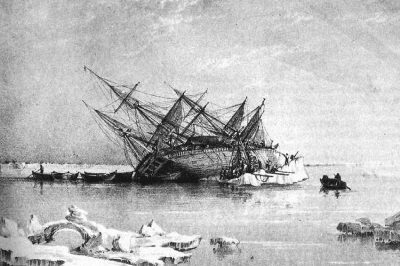 September 26, 2019 HMS Terror: A British Warship That Was Lost for Over 170 Years
- August 16, 2019 Schwerer Gustav: Why the Largest Artillery Gun Turned Out to Be a Flop During World War II?
- July 2, 2019 Varosha: The Abandoned Luxury Retreat in the Mediterranean
The post Maunsell Sea Forts: The Forts That Tell the Tale of WWII appeared first on .
]]>