
With Alternative Systems in the Pipeline, Global Positioning System, GPS is Here to Stay
Share
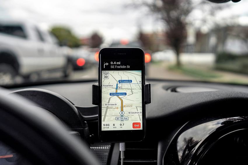
A driver using a global positioning system through his phone. (THE COLLAB. / Pexels)
The day: September 1, 1983. A Korean Air Lines Flight 007, taking off from New York City to Seoul, drifts 200 miles away from the flightpath, towards a sensitive Soviet military installation in the Kamchatka Peninsula. Soviet Pilots detect these intrusions and jump into action. KAL 007, the passenger plane, is mistaken for the spy plane and shot down. If only the KAL 007 had the Global Positioning System (GPS), then used exclusively by the U.S. Military, it would have noted the drift and mended direction. And, the tragedy could have been averted. Lest such navigational lapses repeat, America – the owner of GPS, then opened this facility for civil use all over the world.
Backed by solar power and batteries
GPS was conceived as stealth technology for the reconnaissance and surveillance work of the U.S. Defense Forces. Its formation began with the launching of the first GPS satellite into earth’s orbit in 1978. By the year 1994, it became a group of 24 satellites. Presently there are 32 satellites. Each weighs about 2000 pounds and carries a 17 feet expanse of solar panels. Functional life of a satellite is about 10 years and the duds are replaced with new functional units. Powered by solar energy, and on-board back-up batteries, each satellite is able to transmit 50 Watts or less of electromagnetic power. This generates 2 low-power radio signals which travel by the line-of-sight. That means, barring high-density solids like concrete buildings and mountains, the signals pass through all other mediums (plastic, glass, clouds etc.).
Satellite information is decoded by GPS devices
The signal given out by the Satellites is loaded with 3 types of information:
1. Pseudorandom code: It is an identification of the particular satellite which is sending the information. The satellite page on the GPS device being used on earth gives a clear indication of the sender satellite.
2. Ephemeris data: This shows update on functional status and the orbital-position of the satellite.
3. Almanac data: It has orbital and state (health) information of every satellite in the constellation. The GPS almanac also includes necessary data to correct for distortion caused by the ionosphere.
Geographical positioning is determined by trilateration
Each satellite, circumnavigating 12,500 miles (20,117 kilometers) away in space, makes 2 rotations of the earth in a day. The satellite demarcates a circular zone on the GPS device as the area of the user’s probable location. Circular zones, as indicated by a 2nd and 3rd satellites would naturally intersect, and the point of intersection reveals the geographical position in a narrowed down range. Even a 4th satellite may chip in with yet another intersection. More the number of intersections, more pinpoint and accurate the location of the GPS user. If still more number of satellites come in the loop, even 3-D position (longitude, altitude and latitude) can be assessed. This methodology of zeroing on to the exact geographical position is called trilateration.
Notably, GPS device, like smartphones, can only collect data transmitted by the satellites. It can’t send data back to the Satellite, except when it syncs with cell phone towers and internet for better output. The device can, as an exception, send such synced information to the satellite systems.
Capable of doing lot more than just positioning
GPS device doesn’t just stop at finding the subject location. It also reveals the distance to a projected destination, how long it may take to reach there, the speed of the subject, topography of the area being travelled, time of sunrise and sunset, and much more. Thanks to technological up-gradation, more and more sensitive receivers are now available. These have enhanced GPS reception in a big way. Some adjutant systems too, like WAAS (Wide Area Augmentation system) and DGPS (differential GPS), have ensured better results. WAAS accounts for atmospheric variations and the geographical position is homed in by more than 3 meters. The correction ensured by DGPS, (used by the U.S. Coast Guard), is in the range of 1-3 meters. With further research and development, tracking of 20 or more satellites could be a possibility. More the number of satellites engaged, better theresults. However, starting from 2018 the U.S. Coast Guard has slowly started to discontinue the use of DGPS due to the increase in the accuracy of GPS technology.
Can the reading on GPS device go wrong?
Yes. Satellites, apart from expiring in 10-year time, can also be obstructed temporarily. Like, conditions in troposphere (the atmosphere 6-20 KM above the sea level), and ionosphere (1000 KM above the sea level) may cause signals to move slowly. Signals may also bump off some high-density solid on earth and lead to error in positioning.
What if America asserts its ownership of GPS?
By and large, GPS is a freebie from America. That, ironically, is its plus as well as minus. Plus, because it is being used extensively and intensively all over the world. Minus, because nothing really comes for free. On all good things, there is a price tag, overt or covert. Of the two levels of GPS services available, Standard Positioning Service (SPS) is free for use worldwide. The other level, Precise Positioning Service (PPS), is not for all. Its use is limited to American Armed forces, federal agencies and some selected nations. What if America decides to restrict worldwide use of GPS? It would indeed rattle the world, overly dependent on GPS in many ways. Is the world ready to face this eventuality?
World moving in the direction of alternatives
Yes, the world seems to be geared up for GPS road-block. Russia has built its own satellite cluster in space, called GLONASS (Global Navigation Satellite System). Galileo is another system, owned by the European Space Agency. China is busy expanding BeiDou to increase its global coverage. Most gadgets are receptive to GLONASS and GPS, and to some extent to BeiDou. The Indian counterpart is IRNSS (Indian Regional Navigation Satellite System), also called NAVIC. Nevertheless, GPS remains the most widely used system as of now.
In spite of competition, GPS holds ground
Blaine Curcio, founder of Orbital Gateway Consulting, a satellite market research firm opines that the satellite navigation services of the future will divide the world into two camps. One: pro-China. Two: pro-US. The pro-China lobby would include nations sceptical of the service provided by the U.S. and the European Union.
Is there a pressing need for alternative navigation systems?
No, feels Curcio. Rightly so, for more reasons than one. According to Brian Weeden, director of the Secure World Foundation states that- the biggest merit of GPS is its consistency and reliability. Further, he says, establishing a global satellite navigation system and making it trust worthy, like GPS, is a hard job. Add to this the fact that BeiDou would be a two-way transmission. Satellite to device on earth, and from device to the satellite. This 2-way track would need more of spectrum bandwidth and the accuracy of positioning could be compromised.
What has ostensibly annoyed the Western countries is the probable role of BeiDou in China’s plan for a smaller & smarter military. It could be used for precision-guided missiles, reconnaissance, and short messages (the facility lacking with GPS). Doubtless, it would add to the military might of China significantly. Not surprising, considering GPS too was developed for the U.S. Military, and used for the first time in the Gulf War.
Keen contest among the nations of the world would indeed change the present day scenario of the global positioning systems. But it won’t come a day too soon. And GPS is likely to hold ground for pretty long.
Enjoyed this article? Also, check out “Yellow Concrete Arrows Are the Last Reminders of Transcontinental Airway System“.
Fact Analysis:
STSTW Media strives to deliver accurate information through careful research. However, things can go wrong. If you find the above article inaccurate or biased, please let us know at [email protected]
RELATED
 April 2, 2019 Yellow Concrete Arrows Are the Last Reminders of Transcontinental Airway System
 May 13, 2019 Radar Technology’s Early Detection System Revolutionised the World and Made it a Better Place to Live in
 September 10, 2019 John Stapp: The Air Force Pilot who Survived the Fastest Rocket Powered Sled
 October 7, 2018 Tesla Tower: The Tragic Story of Nikola Tesla’s Wardenclyffe Wireless Station


